

New York State Route 28N
Encyclopedia
New York State Route 28N (NY 28N) is a state highway
in the Adirondacks in New York
that extends from Blue Mountain Lake
to North Creek
. The route, 50.95 miles (82 km) in length, is a northerly alternate route to NY 28
between both locations. The highway passes through several communities before terminating at Route 28 in North Creek. Over its western end, it undergoes a 10 miles (16 km) concurrency with NY 30
through the town of (named after the lake) Long Lake
, where Route 30 splits off, and Route 28N heads eastward through mountainous regions of the Adirondack Park.
The 40 miles (64 km) section of NY 28N not concurrent
with NY 30
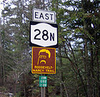
is designated as the Roosevelt-Marcy Trail
, a scenic byway named for Theodore Roosevelt
, who was then the Vice President of the United States
. The byway marks the path Roosevelt took in 1901 to reach North Creek from Mount Marcy
after learning that President William McKinley
had been assassinated. The route has a rather scant history before its designations. The road originated as an old highway stretching from Warren County to Long Lake. It was used for transportation in the iron ore industry in Newcomb, and for the lumber industry in Minerva
. New York State gained control of the road in 1909. The Route 28N designation was assigned as part of the 1930 renumbering, incorporating part of pre-1930 Route 10.
and NY 30
near the hamlet of Blue Mountain Lake
within the town of Indian Lake
. The highway, concurrent with Route 30, heads north through the hamlet
nestled at the base of Blue Mountain
, one of the highest peaks in Adirondack Park standing, 3795 feet (1,156.7 m) above sea level. Routes 28N and 30 track north, gaining elevation after leaving Blue Mountain Lake. Nestled between Blue Mountain and Peaked Mountain, Routes 28N and 30 turn northeast. After intersecting Salmon Pond Road, the highways wind through the mountains and hills of the Adirondacks. Mud Pond and South Pond are on the west, and East Inlet Mountain is on the east. After paralleling Long Lake
and the base of East Inlet Mountain, the highways enter the hamlet of Long Lake
, where they split. Route 30 heads northwest, while Route 28N turns eastward towards Newcomb
.
 Beyond Long Lake, Route 28N partially remains in a mountainous region; Pinnacle Mountain, a 2159 feet (658.1 m) peak, rises to the north, while lowlands lie to the south. The highway progresses eastward, passing Windfall Mountain and proceeding through the center of the park. Route 28N crosses into Essex County
, where it becomes the Roosevelt-Marcy Trail, one of 13 scenic byways in the Adirondack Park. The highway, first turning southeast for a short distance, turns east again, passing south of Rich Lake. The two-lane highway passes Baldwin Mountain to the north, and subsequently enters Newcomb, an isolated town between Long Lake and North Creek. The highway exits Newcomb as it approaches the shores of Harris Lake. After crossing one of those creeks, the highway turns to the southeast and into Winebrook Hills.
Route 28N passes through Winebrook Hills, and intersects with its first signed roads since Long Lake, County Route 75 (CR 75, named Eaton Lane) and CR 84 (Blue Ridge Road
). The latter is a former alignment of NY 73
. Nearby is Vanderwhacker Mountain, a 3386 feet (1,032.1 m) high peak and part of the Vanderwhacker Mountain Wild Forest, which the highway passes through. CR 84 eventually parallels the highway to the north of Route 28N, but this slowly begins to change as the main highway begins to progress southward. Route 28N heads south into the hamlet of Aiden Lair and continues south towards Warren County
. The highway crosses Boreas Creek, which flows southwest in the park, and eventually passes a series of lakes. Route 28N enters Minerva, where it intersects several county routes, including Route 29, which heads towards the Warren County border and Interstate 87 (I-87).
The road, after leaving Minerva, passes Moxham Mountain, a 2200 feet (670.6 m) peak, and eventually crosses the Hudson River
. The route ends just after entering North Creek
in Warren County, at the intersection with NY 28
, its parent route.
Route 28N is classified as a rural major collector road
, with the exception of the section that is overlapped with Route 30, which is classified as a rural minor arterial road
. As of 2006, the Route 30 overlap had an average annual daily traffic of 1,781 vehicles. Traffic volumes are reduced to 1,231 vehicles per day from the end of the Route 30 overlap to the intersection with Blue Ridge Road (CR 84). South of this intersection, traffic is reduced further to 350 until the hamlet of Minerva, rising to 751 south of Minerva until near the Warren county line. Traffic increases back up to 1,248 vehicles per day from there to Route 28 in North Creek.
 Many of the earliest roads in the area crossed through Minerva. The first known road that reached the settlement was established in 1804, when land along a highway from Saint Lawrence County to the town of Chester in Warren County, was populated by the West family. Minerva was mainly limited to the vicinity of the old highway, but as more people settled along the road, the town began to grow. For a time, the town boasted several water-powered sawmills, and the highway was used to transport lumber. However, the lumber industry began to fail, and by 1840, the logging and lumber system had been replaced by crops. The town initiated river drives, which continued until 1950.
On March 15, 1828, part of Minerva and nearby Moriah
was split into the town of Newcomb. Settlers began to arrive in this area in 1816. Settlement began along the shores of Lake Harris and Newcomb Lake, mainly along the old highway from Warren County to nearby Long Lake. Eventually, highways helped the town grow, and it reached a population of 300 by the 1880 census. The iron ore industry contributed to population growth via 30 miles (48 km) to 40 miles (64 km) roads to Lake Champlain
that were meant for hauling ore. The highway from Warren County to Long Lake became part of the state system as early as 1909. After 1845, Newcomb's iron ore industry began to decline and the town evolved into somewhat of a sportsmen's resort. As a result, a road was built connecting Newcomb with nearby Minerva and Long Lake.
The 40 miles (64 km) section of 28N between Long Lake and North Creek is a scenic byway named the Roosevelt-Marcy Trail
. This was the route traveled on September 10, 1901 by Theodore Roosevelt, then Vice President of the United States. The vice president had hiked to the summit of nearby Mount Marcy earlier, while there, learned that President William McKinley
, having been shot four days earlier by anarchist Leon Czolgosz in Buffalo
, was near death. Roosevelt took an overnight wagon ride to North Creek. From the train station there, he traveled to Buffalo, where, after McKinley died, he was sworn in as president on September 14.
to North Creek
was designated as part of the signed NY 10. The segment of former Route 25 between Blue Mountain Lake
and Long Lake became part of NY 10A in the late 1920s. In the 1930 renumbering, the NY 10A designation was eliminated, and NY 10 was rerouted south of Long Lake to follow the modern routing of NY 30
south to Speculator
. The former routing of NY 10 between Long Lake and North Creek was then administratively redesignated as NY 28N, which continued southward from Long Lake to Blue Mountain Lake by way of an overlap with NY 10.
The New York State Department of Transportation
has scheduled for Route 28N to undergo construction in spring 2013, to rehabilitate the bridge over the Upper Hudson River Railroad
. The $5.9 million project is projected to be complete in fall of 2015, and is to be supported by state and federal funds. New York State Department of Transportation
has also planned for Route 28N's bridge over Stillwater Brook in Minerva to be replaced with a stronger structure. The development of the project is expected to take place 2014, with bids and construction starting in 2016. The project has been set to end in 2017, and is predicted to cost $1.1 million of federal and state funds.
State highway
State highway, state road or state route can refer to one of three related concepts, two of them related to a state or provincial government in a country that is divided into states or provinces :#A...
in the Adirondacks in New York
New York
New York is a state in the Northeastern region of the United States. It is the nation's third most populous state. New York is bordered by New Jersey and Pennsylvania to the south, and by Connecticut, Massachusetts and Vermont to the east...
that extends from Blue Mountain Lake
Blue Mountain Lake, New York
Blue Mountain Lake is a rural hamlet in the Town of Indian Lake of Hamilton County, New York located at the intersection of New York Routes 28 and 30 with a population of 146 according to the 2000 United States Census. Blue Mountain Lake also refers to the lake on the banks of which the village is...
to North Creek
North Creek, New York
North Creek is a hamlet in the Adirondack Park, in the town of Johnsburg, in Warren County, New York, United States. It is an area known for skiing , hiking and other outdoor recreational activities. It is located at ....
. The route, 50.95 miles (82 km) in length, is a northerly alternate route to NY 28
New York State Route 28
New York State Route 28 is a state highway extending for in the shape of a "C" between the Hudson Valley city of Kingston and southern Warren County in the U.S. state of New York. Along the way, it intersects several major routes, including Interstate 88 , U.S. Route 20 , and the...
between both locations. The highway passes through several communities before terminating at Route 28 in North Creek. Over its western end, it undergoes a 10 miles (16 km) concurrency with NY 30
New York State Route 30
New York State Route 30 is a state highway in the central part of New York in the United States. It extends for from an interchange with NY 17 in the Southern Tier to the Canadian border in the state's North Country, where it continues into Quebec as Route 138. On a regional level,...
through the town of (named after the lake) Long Lake
Long Lake, New York
Long Lake is a town in Hamilton County, New York in the United States. The population was 852 at the 2000 census. The town is named for long Long Lake beside which it sits. The town is entirely within the Adirondack Park and is the most northerly town in the county. It is a summer tourism...
, where Route 30 splits off, and Route 28N heads eastward through mountainous regions of the Adirondack Park.
The 40 miles (64 km) section of NY 28N not concurrent
Concurrency (road)
A concurrency, overlap, or coincidence in a road network is an instance of one physical road bearing two or more different highway, motorway, or other route numbers...
with NY 30
New York State Route 30
New York State Route 30 is a state highway in the central part of New York in the United States. It extends for from an interchange with NY 17 in the Southern Tier to the Canadian border in the state's North Country, where it continues into Quebec as Route 138. On a regional level,...
is designated as the Roosevelt-Marcy Trail
Roosevelt-Marcy Trail
The Roosevelt-Marcy Trail is named for the historic route Vice President Theodore Roosevelt traveled on a dangerous midnight stagecoach ride from Tahawus to the North Creek train station to take the Presidential oath....
, a scenic byway named for Theodore Roosevelt
Theodore Roosevelt
Theodore "Teddy" Roosevelt was the 26th President of the United States . He is noted for his exuberant personality, range of interests and achievements, and his leadership of the Progressive Movement, as well as his "cowboy" persona and robust masculinity...
, who was then the Vice President of the United States
Vice President of the United States
The Vice President of the United States is the holder of a public office created by the United States Constitution. The Vice President, together with the President of the United States, is indirectly elected by the people, through the Electoral College, to a four-year term...
. The byway marks the path Roosevelt took in 1901 to reach North Creek from Mount Marcy
Mount Marcy
Mount Marcy is the highest point in New York State, with an elevation of . It is a popular destination for hikers due to its stature and great views, and the peak can get very crowded in the summer months...
after learning that President William McKinley
William McKinley
William McKinley, Jr. was the 25th President of the United States . He is best known for winning fiercely fought elections, while supporting the gold standard and high tariffs; he succeeded in forging a Republican coalition that for the most part dominated national politics until the 1930s...
had been assassinated. The route has a rather scant history before its designations. The road originated as an old highway stretching from Warren County to Long Lake. It was used for transportation in the iron ore industry in Newcomb, and for the lumber industry in Minerva
Minerva, New York
Minerva is a town in Essex County, New York, United States. The population was 796 at the 2000 census. The town is named after Minerva, goddess of wisdom.The Town of Minerva is located in the southwest corner of the county...
. New York State gained control of the road in 1909. The Route 28N designation was assigned as part of the 1930 renumbering, incorporating part of pre-1930 Route 10.
Route description
NY 28N begins at the intersection with NY 28New York State Route 28
New York State Route 28 is a state highway extending for in the shape of a "C" between the Hudson Valley city of Kingston and southern Warren County in the U.S. state of New York. Along the way, it intersects several major routes, including Interstate 88 , U.S. Route 20 , and the...
and NY 30
New York State Route 30
New York State Route 30 is a state highway in the central part of New York in the United States. It extends for from an interchange with NY 17 in the Southern Tier to the Canadian border in the state's North Country, where it continues into Quebec as Route 138. On a regional level,...
near the hamlet of Blue Mountain Lake
Blue Mountain Lake, New York
Blue Mountain Lake is a rural hamlet in the Town of Indian Lake of Hamilton County, New York located at the intersection of New York Routes 28 and 30 with a population of 146 according to the 2000 United States Census. Blue Mountain Lake also refers to the lake on the banks of which the village is...
within the town of Indian Lake
Indian Lake, New York
Indian Lake is a town in Hamilton County, New York, United States. The population was 1,471 at the 2000 census. The name is from a large lake partly inside the town.The Town of Indian Lake is on the east border of the county and is northeast of Utica....
. The highway, concurrent with Route 30, heads north through the hamlet
Hamlet (place)
A hamlet is usually a rural settlement which is too small to be considered a village, though sometimes the word is used for a different sort of community. Historically, when a hamlet became large enough to justify building a church, it was then classified as a village...
nestled at the base of Blue Mountain
Blue Mountain (New York)
Blue Mountain is a peak in the Adirondack Mountains of New York State in the United States. Located in Indian Lake, Hamilton County, the peak reaches a height of 3750ft/1143m. For hiking, the elevation gain is 1,559 feet and the trail length is four miles. The trailhead elevation is 2,200 feet...
, one of the highest peaks in Adirondack Park standing, 3795 feet (1,156.7 m) above sea level. Routes 28N and 30 track north, gaining elevation after leaving Blue Mountain Lake. Nestled between Blue Mountain and Peaked Mountain, Routes 28N and 30 turn northeast. After intersecting Salmon Pond Road, the highways wind through the mountains and hills of the Adirondacks. Mud Pond and South Pond are on the west, and East Inlet Mountain is on the east. After paralleling Long Lake
Long Lake (New York)
Long Lake is a lake in the town of Long Lake in Hamilton County, New York in the United States; the average width is half a mile. It is part of the Raquette River, which flows in a straight, northeast-trending valley. NY 30 crosses at a narrows from the south end where the hamlet of Long Lake is...
and the base of East Inlet Mountain, the highways enter the hamlet of Long Lake
Long Lake, New York
Long Lake is a town in Hamilton County, New York in the United States. The population was 852 at the 2000 census. The town is named for long Long Lake beside which it sits. The town is entirely within the Adirondack Park and is the most northerly town in the county. It is a summer tourism...
, where they split. Route 30 heads northwest, while Route 28N turns eastward towards Newcomb
Newcomb, New York
Newcomb is a town in Essex County, New York, United States. The population was 481 at the 2000 census.The Town of Newcomb is at the west border of the county. It is southwest of Plattsburgh, southwest of Burlington, VT, northeast of Utica, NY, north-northeast of Albany, NY, and ...
.
Essex County, New York
Essex County is a county located in the U.S. state of New York. As of the 2010 census, the population was 39,370. Its name is from the English county of Essex. Its county seat is Elizabethtown...
, where it becomes the Roosevelt-Marcy Trail, one of 13 scenic byways in the Adirondack Park. The highway, first turning southeast for a short distance, turns east again, passing south of Rich Lake. The two-lane highway passes Baldwin Mountain to the north, and subsequently enters Newcomb, an isolated town between Long Lake and North Creek. The highway exits Newcomb as it approaches the shores of Harris Lake. After crossing one of those creeks, the highway turns to the southeast and into Winebrook Hills.
Route 28N passes through Winebrook Hills, and intersects with its first signed roads since Long Lake, County Route 75 (CR 75, named Eaton Lane) and CR 84 (Blue Ridge Road
Blue Ridge Road
Blue Ridge Road is a long roadway in Essex County, New York, in the United States. The road is designated as County Route 84 from NY 28N in Newcomb to Interstate 87 in North Hudson, and as New York State Route 910K between I-87 and U.S. Route 9 in North Hudson...
). The latter is a former alignment of NY 73
New York State Route 73
New York State Route 73 is a state highway located entirely within Essex County, New York, United States. The highway begins at an intersection with NY 86 in the village of Lake Placid and ends at a junction with U.S. Route 9 north of the hamlet of Underwood in the extreme...
. Nearby is Vanderwhacker Mountain, a 3386 feet (1,032.1 m) high peak and part of the Vanderwhacker Mountain Wild Forest, which the highway passes through. CR 84 eventually parallels the highway to the north of Route 28N, but this slowly begins to change as the main highway begins to progress southward. Route 28N heads south into the hamlet of Aiden Lair and continues south towards Warren County
Warren County, New York
Warren County is a county in the U.S. state of New York. It is part of the Glens Falls, New York, Metropolitan Statistical Area. As of the 2010 census, the population was 65,707. It is named in honor of General Joseph Warren, an American Revolutionary War hero of the Battle of Bunker Hill...
. The highway crosses Boreas Creek, which flows southwest in the park, and eventually passes a series of lakes. Route 28N enters Minerva, where it intersects several county routes, including Route 29, which heads towards the Warren County border and Interstate 87 (I-87).
The road, after leaving Minerva, passes Moxham Mountain, a 2200 feet (670.6 m) peak, and eventually crosses the Hudson River
Hudson River
The Hudson is a river that flows from north to south through eastern New York. The highest official source is at Lake Tear of the Clouds, on the slopes of Mount Marcy in the Adirondack Mountains. The river itself officially begins in Henderson Lake in Newcomb, New York...
. The route ends just after entering North Creek
North Creek, New York
North Creek is a hamlet in the Adirondack Park, in the town of Johnsburg, in Warren County, New York, United States. It is an area known for skiing , hiking and other outdoor recreational activities. It is located at ....
in Warren County, at the intersection with NY 28
New York State Route 28
New York State Route 28 is a state highway extending for in the shape of a "C" between the Hudson Valley city of Kingston and southern Warren County in the U.S. state of New York. Along the way, it intersects several major routes, including Interstate 88 , U.S. Route 20 , and the...
, its parent route.
Route 28N is classified as a rural major collector road
Collector road
A collector road or distributor road is a low to moderate-capacity road which serve to move traffic from local streets to arterial roads. Unlike arterials, collectors are also designed to provide access to residential properties...
, with the exception of the section that is overlapped with Route 30, which is classified as a rural minor arterial road
Arterial road
An arterial road, or arterial thoroughfare, is a high-capacity urban road. The primary function of an arterial road is to deliver traffic from collector roads to freeways, and between urban centres at the highest level of service possible. As such, many arteries are limited-access roads, or feature...
. As of 2006, the Route 30 overlap had an average annual daily traffic of 1,781 vehicles. Traffic volumes are reduced to 1,231 vehicles per day from the end of the Route 30 overlap to the intersection with Blue Ridge Road (CR 84). South of this intersection, traffic is reduced further to 350 until the hamlet of Minerva, rising to 751 south of Minerva until near the Warren county line. Traffic increases back up to 1,248 vehicles per day from there to Route 28 in North Creek.
Early history: Newcomb and Minerva
On March 15, 1828, part of Minerva and nearby Moriah
Moriah, New York
Moriah is a town in Essex County, New York, United States. The population was 4,879 at the 2000 census.The Town of Moriah is in the eastern part of the county. It is south-southwest of Burlington, VT, south of Plattsburgh, north of Albany, NY, and south of Montreal, Quebec...
was split into the town of Newcomb. Settlers began to arrive in this area in 1816. Settlement began along the shores of Lake Harris and Newcomb Lake, mainly along the old highway from Warren County to nearby Long Lake. Eventually, highways helped the town grow, and it reached a population of 300 by the 1880 census. The iron ore industry contributed to population growth via 30 miles (48 km) to 40 miles (64 km) roads to Lake Champlain
Lake Champlain
Lake Champlain is a natural, freshwater lake in North America, located mainly within the borders of the United States but partially situated across the Canada—United States border in the Canadian province of Quebec.The New York portion of the Champlain Valley includes the eastern portions of...
that were meant for hauling ore. The highway from Warren County to Long Lake became part of the state system as early as 1909. After 1845, Newcomb's iron ore industry began to decline and the town evolved into somewhat of a sportsmen's resort. As a result, a road was built connecting Newcomb with nearby Minerva and Long Lake.
The 40 miles (64 km) section of 28N between Long Lake and North Creek is a scenic byway named the Roosevelt-Marcy Trail
Roosevelt-Marcy Trail
The Roosevelt-Marcy Trail is named for the historic route Vice President Theodore Roosevelt traveled on a dangerous midnight stagecoach ride from Tahawus to the North Creek train station to take the Presidential oath....
. This was the route traveled on September 10, 1901 by Theodore Roosevelt, then Vice President of the United States. The vice president had hiked to the summit of nearby Mount Marcy earlier, while there, learned that President William McKinley
William McKinley
William McKinley, Jr. was the 25th President of the United States . He is best known for winning fiercely fought elections, while supporting the gold standard and high tariffs; he succeeded in forging a Republican coalition that for the most part dominated national politics until the 1930s...
, having been shot four days earlier by anarchist Leon Czolgosz in Buffalo
Buffalo, New York
Buffalo is the second most populous city in the state of New York, after New York City. Located in Western New York on the eastern shores of Lake Erie and at the head of the Niagara River across from Fort Erie, Ontario, Buffalo is the seat of Erie County and the principal city of the...
, was near death. Roosevelt took an overnight wagon ride to North Creek. From the train station there, he traveled to Buffalo, where, after McKinley died, he was sworn in as president on September 14.
Designation and bridge rehabilitation
The routing of Route 28N was originally designated, but not signed,The road was given a designation, though no actual signs were erected. as part of legislative Route 25 in 1908. In 1924, the portion of Route 25 from Long LakeLong Lake, New York
Long Lake is a town in Hamilton County, New York in the United States. The population was 852 at the 2000 census. The town is named for long Long Lake beside which it sits. The town is entirely within the Adirondack Park and is the most northerly town in the county. It is a summer tourism...
to North Creek
North Creek, New York
North Creek is a hamlet in the Adirondack Park, in the town of Johnsburg, in Warren County, New York, United States. It is an area known for skiing , hiking and other outdoor recreational activities. It is located at ....
was designated as part of the signed NY 10. The segment of former Route 25 between Blue Mountain Lake
Blue Mountain Lake, New York
Blue Mountain Lake is a rural hamlet in the Town of Indian Lake of Hamilton County, New York located at the intersection of New York Routes 28 and 30 with a population of 146 according to the 2000 United States Census. Blue Mountain Lake also refers to the lake on the banks of which the village is...
and Long Lake became part of NY 10A in the late 1920s. In the 1930 renumbering, the NY 10A designation was eliminated, and NY 10 was rerouted south of Long Lake to follow the modern routing of NY 30
New York State Route 30
New York State Route 30 is a state highway in the central part of New York in the United States. It extends for from an interchange with NY 17 in the Southern Tier to the Canadian border in the state's North Country, where it continues into Quebec as Route 138. On a regional level,...
south to Speculator
Speculator, New York
Speculator is a village in Hamilton County, New York, United States. The population was 348 at the 2000 census. The village is named after a nearby Speculator Mountain....
. The former routing of NY 10 between Long Lake and North Creek was then administratively redesignated as NY 28N, which continued southward from Long Lake to Blue Mountain Lake by way of an overlap with NY 10.
The New York State Department of Transportation
New York State Department of Transportation
The New York State Department of Transportation is responsible for the development and operation of highways, railroads, mass transit systems, ports, waterways and aviation facilities in the U.S...
has scheduled for Route 28N to undergo construction in spring 2013, to rehabilitate the bridge over the Upper Hudson River Railroad
Upper Hudson River Railroad
The Upper Hudson River Railroad was a heritage railroad that operates in the upper Hudson River in New York State's Adirondack Mountains that operated from 1999 to 2010....
. The $5.9 million project is projected to be complete in fall of 2015, and is to be supported by state and federal funds. New York State Department of Transportation
New York State Department of Transportation
The New York State Department of Transportation is responsible for the development and operation of highways, railroads, mass transit systems, ports, waterways and aviation facilities in the U.S...
has also planned for Route 28N's bridge over Stillwater Brook in Minerva to be replaced with a stronger structure. The development of the project is expected to take place 2014, with bids and construction starting in 2016. The project has been set to end in 2017, and is predicted to cost $1.1 million of federal and state funds.