
New York State Route 12
Encyclopedia
New York State Route 12 (NY 12) is a state highway
extending for 222.27 miles (357.71 km) through central and northern New York
in the United States
. The southern terminus of the route is at U.S. Route 11
(US 11) in the town of Chenango
(just north of Binghamton) in the Southern Tier
. The northern terminus is at NY 37
near the village of Morristown
in the North Country
. In between, the route serves three cities of varying size: Norwich
, Utica
, and Watertown. The distance between Utica and Binghamton is a major trucking route, and features many gas stations, truck stops, and fast food restaurants. Between Watertown and Morristown, it follows the St. Lawrence River valley.
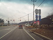
It is a two lane, undivided, full access roadway for the majority of its length, except between the village of New Hartford and Alder Creek, where it is a 4-lane highway. Within that span, it is a limited access highway in the city of Utica, referred locally as The Arterial and the North–South Arterial.
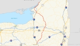
Route 12 intersects several primary east–west routes, including US 20
, NY 5
, and NY 3
. From Barneveld
to the town of Remsen
(a distance of 11 miles or 18 km), NY 12 overlaps NY 28
. NY 12 also intersects US 11 twice: once at its beginning in Binghamton and once in Watertown. Between these intersections, NY 12 arcs eastward from US 11, with the stretch right after Utica being its eastern apex. NY 12 also connects with Interstate 81
(I-81) near both its beginning and end points in the same manner.
NY 12, as originally assigned in 1924, extended from Chenango in the south to Clayton
in the north. It was extended east over the former routing of NY 3 to Alexandria Bay
in 1930, then along a new roadway to Morristown in the 1960s. Parts of NY 12 have been rerouted onto new roadways in areas, primarily in Oneida County
.
north of Binghamton
in the central Broome County
town of Chenango
. The route heads north through the Chenango River
valley, connecting to both I-81
(via US 11) and I-88
(via NY 12A) and passing west of Chenango Valley State Park
before traversing the Tioughnioga River
(just west of where it forks from the Chenango) near the community of Chenango Forks. On the northern bank of the river, NY 12 intersects and briefly overlaps NY 79
before continuing northward through the valley and into Chenango County
.
 Within Chenango County, NY 12 acts as the primary connector between the numerous communities located along the Chenango. In Greene
, NY 12 intersects NY 206
and overlaps NY 41
for six blocks through the village before continuing northeast for 12 miles (19 km) to Oxford
, home to a short concurrency with NY 220
. After another 6 miles (10 km), NY 12 enters the city of Norwich
, the largest settlement on the route in the county, and becomes South Broad Street. The South Broad moniker remains with the route northward through the city until the downtown district, where NY 12 turns into North Broad Street at a junction with NY 23
. NY 12 loses the street name soon afterward as it leaves the city and intersects NY 320
north of Norwich and south of Norwich Lt. Warren Eaton Airport
.
The route and the Chenango River remain in close proximity to one another up through the village of Sherburne
, situated at the junction between NY 12 and NY 80
. North of the village center, the river breaks to the west, following NY 12B
to the northwest while NY 12 continues northward into rural Madison County
.
to just south of the Sangerfield
hamlet of the same name, where the swamp ends as the river curves away from NY 12. At the actual community, NY 12 intersects US 20
.
The route continues north for an additional 1 miles (1.6 km) to the village of Waterville
, home to an intersection between NY 12 and NY 315
. Outside of Waterville, NY 12 heads north once more through hilly, sparsely populated areas of New York toward Utica
. In the Utica suburb
of New Hartford
, the route intersects NY 5
a short distance east of where NY 12B terminates at NY 5. NY 12 turns east, joining NY 5 northeast on a limited-access highway known locally as the North–South Arterial. Upon crossing into the Utica city limits, the Arterial intersects NY 8
and NY 840
by way of a cloverleaf interchange
. NY 8 joins the freeway here, following NY 5 and NY 12 through southern Utica as the arterial meets French Road and Burrstone Road by way of a pair of interchanges. After the Burrstone Road interchange, the arterial becomes a divided highway
through downtown before becoming limited-access once more at an interchange with Oriskany Street (NY 5A
and NY 5S
).
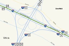 Between Oriskany Street and the New York State Thruway
(I-90), NY 5, 8, and 12 is part of the Interstate Highway System
as I-790
overlaps all three routes northward over the Mohawk River
and the Erie Canal
before leaving the arterial at a large interchange on the north bank of the canal. NY 5 turns off as well, following I-790 eastward. Meanwhile, NY 8 and NY 12 interchange with NY 49
(the Utica–Rome Expressway), partially via the I-790 exit ramps, and passes over the Thruway before continuing northward out of the city limits.
NY 8 and NY 12 remain limited-access as they proceed through the northern suburbs of Utica, connecting to Mulaney Road and Trenton Road via interchanges in Deerfield
. Farther north in the town, NY 8 leaves the freeway by way of a trumpet interchange. Although the amount of development around NY 12 declines as it heads northward, it continues as an expressway to a point north of the Putnam Road interchange in Trenton
, where the road reverts to a limited-access four-lane highway. This configuration remains through the villages of Barneveld
(where NY 28
joins NY 12 south of the village and NY 12 connects to NY 365
via an interchange) and Remsen
to the vicinity of Alder Creek in the town of Boonville
, where NY 28 leaves NY 12 via a partial trumpet interchange and the road narrows to two lanes shortly afterward.
From Alder Creek to Boonville
, NY 12 loosely follows the path of the Black River
as it heads northwest. Inside Boonville, NY 12D
departs NY 12 and begins to follow a northward routing parallel to that of its parent. Together with NY 12D and the Black River, NY 12 passes into the region of New York known as the North Country
.
, urban Watertown, and the numerous communities that line the southern bank of the St. Lawrence River, here the geographical divide between the United States
and Canada
.
to Lyons Falls
, where NY 12D returns to NY 12 by way of an intersection just west of the village. NY 12 then passes under NY 12D, which heads north from NY 12 on Cherry Street to access Lyons Falls before heading west over NY 12 and out of the village. NY 12, however, continues on in the vicinity of the Black River to Lowville
, where NY 12 briefly overlaps NY 26
and meets NY 812
before leaving both the village and the river to the west.
 3 miles (5 km) outside of Lowville at West Lowville, NY 12 leaves its due west alignment and curves to the northwest, with the westerly alignment continuing onward as NY 177
. From West Lowville to the area surrounding Copenhagen
, NY 12 passes through largely undeveloped terrain, save for a pair of isolated roadside communities. This trend ceases, albeit temporary, in the village of Copenhagen, located on the banks of the Deer River at the crossroads of NY 12 and the former NY 194
(now County Route 194 or CR 194). Outside the limits, the route resumes its trek through the rural North Country.
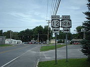
on its way to Watertown just north of Copenhagen
. Route 12 is known as Van Allen Road, crossing with Jefferson county roads in Rutland. At the intersection with County Road 67, Route 12 turns to the north and enters Watertown as Gifford Street. Route 12 intersects with NY 126
just northeast of Thompson Park and Watertown Golf Club and turns to the northwest. As Route 12 continues through southern parts of Watertown, NY 3
intersects and becomes concurrent. Routes 3 and 12 enter Watertown Public Square and split into divided highways. Here, NY 283
starts to the northeast.
Routes 3 and 12 split, just northwest of the Public Square. Route 3 splits to the west, Route 12 heads to the northwest, and quickly becomes concurrent with US 11
. The two roads cross a river and split in different directions. Route 12 heads to the northeast, intersecting with a suffixed route, 12E
, and passes North Watertown Cemetery before connecting to I-81
at exit 47. Route 12 leaves Watertown afterwards and heads northeast through rural northwestern Jefferson County. North of Perch Lake
in the southeastern corner of the town of Clayton
, NY 12 intersects NY 180
.
10 miles (16 km) north of NY 180, NY 12 reaches the village of Clayton
on the St. Lawrence River. Inside the village, NY 12E completes its lengthy alternate loop of NY 12, terminating at its parent in the village center. NY 12 turns east here, following State Street out of Clayton.
-bound ferry
) and NY 180
, and passing south of Grass Point State Park
prior to encountering I-81 at exit 50 4 miles (6 km) southwest of the village of Alexandria Bay
. Farther northeast, NY 12 passes by Keewaydin State Park
before intersecting the northern terminus of NY 26
in the southwestern portion of the village.
Outside of Alexandria Bay, NY 12 temporarily turns east and leaves the riverbank to avoid Goose Bay, a small body of water partially separated from the St. Lawrence by two protruding points of land. The route then curves back toward the water and follows the eastern length of the bay, serving the seaside hamlet of Goose Bay near the bay's midpoint. North of Goose Bay, NY 12 intersects Kring Point Road, an access road leading to Kring Point State Park
, and crosses into St. Lawrence County
.
NY 12 continues along the southern bank of the St. Lawrence River as it proceeds through the rural western portion of the county. 5 miles (8 km) from the county line and 11 miles (18 km) from Alexandria Bay in the town of Hammond
, NY 12 intersects CR 6, a roadway leading east to the village of Hammond
and Black Lake
. Farther north in Morristown
, NY 12 travels through Jacques Cartier State Park
before terminating at an interchange with NY 37
just south of the Morristown
village limits.
extending from Binghamton to Kirkland
(west of Utica
) via Greene
, Norwich
, Sherburne
, Bouckville, and Oriskany Falls
. Also assigned at this time was Route 25, which passed through Barneveld
, Remsen
and Forestport
on its way from Whitesboro
to Albany
, and Route 27, which began at Route 25 in Forestport and went northwest to Alexandria Bay
by way of Boonville
, Potters Corners, Lowville
, Carthage
, Watertown
, and Clayton
. Route 25 originally went directly from Barneveld to Remsen; however, it was realigned by 1920 to serve the village of Prospect
to the east.
When the first set of posted routes in New York
were assigned in 1924, NY 12 was assigned to an alignment extending from Binghamton to Clayton via Norwich, Utica, and Watertown. It utilized legislative Route 8 from Binghamton to just south of Clinton
, where it veered northeast to serve the city of Utica instead of continuing north on Route 6 (modern NY 233
) to Kirkland. In the vicinity of Utica, NY 12 initially followed Clinton Road, Genesee Street, and Trenton Road through the city. Past Utica, it continued north on Trenton Road to a point south of Trenton (now Barneveld
), where it briefly followed its current routing. NY 12 turned off again in Trenton to follow legislative Route 25's original alignment on Mappa Avenue in Trenton and Main Street in Remsen. NY 12 continued north from Remsen on legislative Route 25.
At Forestport, NY 12 left Route 25 to follow legislative Route 27 to Lowville. In Lowville, NY 12 split from Route 27 and proceeded northwest to Watertown via Copenhagen
, bypassing the slightly more circuitous route that Route 27 took via Carthage on modern NY 26
, NY 126
, and NY 3
. NY 12 rejoined legislative Route 27 in Watertown and followed it to Clayton, where NY 12 ended at NY 3, which was also assigned in 1924. At the time, the segment of legislative Route 27 between Clayton and Alexandria Bay was designated as part of NY 3.
. Its former routing to the west became NY 12A (now NY 12B
). As a result, NY 12 now entered Utica on Paris Road. In the 1930 renumbering of state highways in New York, NY 3 was rerouted onto its current alignment east of Watertown while the former routing of NY 3 from Clayton to Alexandria Bay became an extension of NY 12. Also created as part of the renumbering was NY 12D
, an alternate route of NY 12 between Potters Corners and Lowville via Lyons Falls
. By the following year, NY 12D was rerouted south of Lyons Falls to follow a routing similar to modern NY 12 to Boonville. The alignments of NY 12 and NY 12D between the two villages were swapped ca. 1939, placing NY 12D on the direct highway between the two and NY 12 on the slightly more circuitous route via Lyons Falls.
NY 12 originally extended southward into downtown Binghamton by way of an overlap with US 11. The overlap was eliminated at some point between 1947 and 1970. On its north end, NY 12 was extended northeast over a new roadway along the St. Lawrence River to NY 37
in Morristown
in the mid-1960s.
s and limited-access highways over the years, particularly in Oneida County
, to bypass communities along its routing. The first bypass that was constructed in Oneida County was around Remsen in the early 1950s. NY 12 was realigned onto the bypass, which passed to the west of the village, by 1954. Construction began by 1956 on a southward extension of the bypass that would take NY 12 around the eastern edge of Barneveld. It opened to traffic by 1958. Farther south, in Utica, a new limited-access highway was built through the downtown portion of the city in the early 1960s. At the time, it began at French Road and ended at Trenton Road. It became a realignment of NY 12 by 1964. An extension of the road southwest to Genesee Street in New Hartford
was completed by 1968, at which time NY 12 was realigned to follow New Paris Road into the city. A limited-access highway bypassing Trenton Road and linking the Utica expressway and the Barneveld–Remsen bypass was completed by 1973, resulting in the rerouting of NY 12 onto the roadway. The former routing of NY 12 along Trenton Road from the Utica city line to Powell Road is now CR 91.
The route has also been realigned in areas to bypass smaller communities along the highway. One such location is in the vicinity of the village of Greene
, where NY 12 initially followed Chenango Street through the village. The current bypass around the western edge of the village was built in the late 1970s and completed by 1981.
 NY 12 has had seven suffixed routes bearing six different designations. Two have since been removed and at least partially renumbered. All of the routes were assigned as part of the 1930 renumbering of state highways in New York unless otherwise noted.
State highway
State highway, state road or state route can refer to one of three related concepts, two of them related to a state or provincial government in a country that is divided into states or provinces :#A...
extending for 222.27 miles (357.71 km) through central and northern New York
New York
New York is a state in the Northeastern region of the United States. It is the nation's third most populous state. New York is bordered by New Jersey and Pennsylvania to the south, and by Connecticut, Massachusetts and Vermont to the east...
in the United States
United States
The United States of America is a federal constitutional republic comprising fifty states and a federal district...
. The southern terminus of the route is at U.S. Route 11
U.S. Route 11 in New York
U.S. Route 11 is a part of the U.S. Highway System that runs from New Orleans, Louisiana, to the Canadian border at Rouses Point, New York...
(US 11) in the town of Chenango
Chenango, New York
Chenango is a town in Broome County, New York, United States. The population was 11,454 at the 2000 census.The Town of Chenango is in the eastern part of the county, northeast of Binghamton.- History :The town was first settled around 1787....
(just north of Binghamton) in the Southern Tier
Southern Tier
The Southern Tier is a geographical term that refers to the counties of New York State west of the Catskill Mountains along the northern border of Pennsylvania. It is a loosely defined term that generally includes the counties that border Pennsylvania west of Delaware County inclusive...
. The northern terminus is at NY 37
New York State Route 37
New York State Route 37 is a state highway in the North Country of New York in the United States, extending for on a west–east axis. The western terminus of the route is at an intersection with U.S. Route 11 in Watertown, Jefferson County...
near the village of Morristown
Morristown (village), New York
Morristown is a village along the Saint Lawrence River in St. Lawrence County, New York, United States. The population was 456 at the 2000 census...
in the North Country
North Country, New York
The North Country is a region of the U.S. state of New York that encompasses the state's extreme northern frontier, bordering Lake Ontario on the west, the Saint Lawrence River and the Canadian provinces of Ontario and Quebec on the north and northwest, and Lake Champlain and Vermont on the east...
. In between, the route serves three cities of varying size: Norwich
Norwich (city), New York
Norwich is a city in Chenango County, New York, United States. Surrounded on all sides by the Town of Norwich, the city is the county seat of Chenango County. The name is taken from Norwich, Connecticut. Its population was 7,355 at the 2000 census.Lt...
, Utica
Utica, New York
Utica is a city in and the county seat of Oneida County, New York, United States. The population was 62,235 at the 2010 census, an increase of 2.6% from the 2000 census....
, and Watertown. The distance between Utica and Binghamton is a major trucking route, and features many gas stations, truck stops, and fast food restaurants. Between Watertown and Morristown, it follows the St. Lawrence River valley.
It is a two lane, undivided, full access roadway for the majority of its length, except between the village of New Hartford and Alder Creek, where it is a 4-lane highway. Within that span, it is a limited access highway in the city of Utica, referred locally as The Arterial and the North–South Arterial.
Route 12 intersects several primary east–west routes, including US 20
U.S. Route 20 in New York
U.S. Route 20 is a part of the U.S. Highway System that runs from Newport, Oregon, to Boston, Massachusetts. In the U.S. state of New York, US 20 extends from the Pennsylvania state line at Ripley to the Massachusetts state line in the Berkshire Mountains. US 20 is the longest...
, NY 5
New York State Route 5
New York State Route 5 is a state highway that extends for across the state of New York in the United States. It begins at the Pennsylvania state line in the Chautauqua County town of Ripley and passes through Buffalo, Syracuse, Utica, Schenectady, and several other smaller cities and...
, and NY 3
New York State Route 3
New York State Route 3 is a major east–west state highway in New York, United States, that connects central New York to the North Country region near the Canadian border via Adirondack Park. The route extends for between its western terminus at an intersection with NY 104A in the Cayuga...
. From Barneveld
Barneveld, New York
Barneveld is a village located within the Town of Trenton in Oneida County, New York, United States. The population was 332 at the 2000 census. The village name is derived from the name of the Dutch statesman Johan van Oldenbarnevelt ....
to the town of Remsen
Remsen (town), New York
Remsen is a town in Oneida County, New York, United States. The population was 1,958 at the 2000 census. The town is named after Henry Remsen, an early settler.The Town of Remsen has a village called Remsen...
(a distance of 11 miles or 18 km), NY 12 overlaps NY 28
New York State Route 28
New York State Route 28 is a state highway extending for in the shape of a "C" between the Hudson Valley city of Kingston and southern Warren County in the U.S. state of New York. Along the way, it intersects several major routes, including Interstate 88 , U.S. Route 20 , and the...
. NY 12 also intersects US 11 twice: once at its beginning in Binghamton and once in Watertown. Between these intersections, NY 12 arcs eastward from US 11, with the stretch right after Utica being its eastern apex. NY 12 also connects with Interstate 81
Interstate 81 in New York
Interstate 81 is a part of the Interstate Highway System that runs from Dandridge, Tennessee, to the Canada – United States border at Wellesley Island in New York. In the U.S. state of New York, I-81 extends from the Pennsylvania state line southeast of Binghamton to the Canadian border...
(I-81) near both its beginning and end points in the same manner.
NY 12, as originally assigned in 1924, extended from Chenango in the south to Clayton
Clayton (village), New York
Clayton is a village located in the Town of Clayton in Jefferson County, New York, USA. The population was 1,821 at the 2000 census. The name is derived from the name of the town....
in the north. It was extended east over the former routing of NY 3 to Alexandria Bay
Alexandria Bay, New York
Alexandria Bay is a village in Jefferson County, New York, United States. The population was 1,080 at the 2010 census.The Village of Alexandria Bay is in the Town of Alexandria.Keewaydin State Park is southeast of the village...
in 1930, then along a new roadway to Morristown in the 1960s. Parts of NY 12 have been rerouted onto new roadways in areas, primarily in Oneida County
Oneida County, New York
Oneida County is a county located in the U.S. state of New York. As of the 2010 census, the population was 234,878. The county seat is Utica. The name is in honor of the Oneida, an Iroquoian tribe that formerly occupied the region....
.
Broome and Chenango Counties
NY 12 begins at US 11U.S. Route 11 in New York
U.S. Route 11 is a part of the U.S. Highway System that runs from New Orleans, Louisiana, to the Canadian border at Rouses Point, New York...
north of Binghamton
Binghamton, New York
Binghamton is a city in the Southern Tier of New York in the United States. It is near the Pennsylvania border, in a bowl-shaped valley at the confluence of the Susquehanna and Chenango Rivers...
in the central Broome County
Broome County, New York
Broome County is a county located in the U.S. state of New York. As of the 2010 census, the population was 200,600. It was named in honor of John Broome, who was lieutenant governor in 1806 when Broome County was established. Its county seat is Binghamton, which is also its major city. The current...
town of Chenango
Chenango, New York
Chenango is a town in Broome County, New York, United States. The population was 11,454 at the 2000 census.The Town of Chenango is in the eastern part of the county, northeast of Binghamton.- History :The town was first settled around 1787....
. The route heads north through the Chenango River
Chenango River
The Chenango River is a tributary of the Susquehanna River in central New York in the United States. It drains a dissected plateau area in upstate New York at the northern end of the Susquehanna watershed....
valley, connecting to both I-81
Interstate 81 in New York
Interstate 81 is a part of the Interstate Highway System that runs from Dandridge, Tennessee, to the Canada – United States border at Wellesley Island in New York. In the U.S. state of New York, I-81 extends from the Pennsylvania state line southeast of Binghamton to the Canadian border...
(via US 11) and I-88
Interstate 88 (east)
Interstate 88 is an intrastate Interstate Highway entirely within the U.S. state of New York. Its western end is at Interstate 81 in Binghamton and its eastern end is at Interstate 90 in Schenectady. It serves as an important connector route from Albany to Binghamton, Elmira , and...
(via NY 12A) and passing west of Chenango Valley State Park
Chenango Valley State Park
Chenango Valley State Park is a state park located in Broome County, New York, USA. The park is located in western part of the Town of Fenton adjacent to the Chenango River....
before traversing the Tioughnioga River
Tioughnioga River
The Tioughnioga River is a tributary of the Chenango River in central New York in the United States. It drains a dissected plateau area east of the Finger Lakes at the northernmost edge of the watershed of the Susquehanna River....
(just west of where it forks from the Chenango) near the community of Chenango Forks. On the northern bank of the river, NY 12 intersects and briefly overlaps NY 79
New York State Route 79
New York State Route 79 is an east–west state highway in the Southern Tier of New York, United States. The western terminus of the route is at the intersection with NY 414 near the southern end of Seneca Lake east of Watkins Glen...
before continuing northward through the valley and into Chenango County
Chenango County, New York
Chenango County is a county located in the U.S. state of New York. As of the 2010 census, the population was 50,477. The county's name originates from an Oneida word meaning "large bull-thistle." Its county seat is Norwich.-History:...
.
Greene (village), New York
Greene is a village in Chenango County, New York, USA. The population was 1,701 at the 2000 census. The village is named after General Nathanael Greene.The Village of Greene is within the Town of Greene and is northeast of Binghamton, New York....
, NY 12 intersects NY 206
New York State Route 206
New York State Route 206 is a state highway in the Southern Tier of New York, United States. It runs through some lightly populated regions along the state's southern border, from Central New York to the Catskills. It begins near a busy intersection with Interstate 81 at Whitney Point...
and overlaps NY 41
New York State Route 41
New York State Route 41 is a north–south state highway in Central New York, United States. The southern terminus of the route is at an interchange with NY 17 in the town of Sanford. Its northern terminus is at an intersection with U.S. Route 20 in the village of Skaneateles...
for six blocks through the village before continuing northeast for 12 miles (19 km) to Oxford
Oxford, New York
Oxford is a town in Chenango County, New York, United States. The town contains a village named Oxford. Oxford is an interior town in the south-central part of the county, southwest of the City of Norwich. At the 2000 census the town population was 3,992...
, home to a short concurrency with NY 220
New York State Route 220
New York State Route 220 is a state highway located in Chenango County, New York, United States. It is signed as an east–west highway, but its actual routing wanders considerably from north to south as it proceeds across the county. The western terminus of NY 220 is at an intersection...
. After another 6 miles (10 km), NY 12 enters the city of Norwich
Norwich (city), New York
Norwich is a city in Chenango County, New York, United States. Surrounded on all sides by the Town of Norwich, the city is the county seat of Chenango County. The name is taken from Norwich, Connecticut. Its population was 7,355 at the 2000 census.Lt...
, the largest settlement on the route in the county, and becomes South Broad Street. The South Broad moniker remains with the route northward through the city until the downtown district, where NY 12 turns into North Broad Street at a junction with NY 23
New York State Route 23
New York State Route 23 is an east–west state highway in the eastern portion New York in the United States. It extends for from an intersection with NY 26 in the Central New York town of Cincinnatus to the Massachusetts state line in the Berkshire Mountains, where it continues east as...
. NY 12 loses the street name soon afterward as it leaves the city and intersects NY 320
New York State Route 320
New York State Route 320 is an east–west state highway located within Chenango County in the central part of New York, United States. The western terminus of the route is at an intersection with NY 12 immediately north of the city of Norwich in the surrounding town of Norwich...
north of Norwich and south of Norwich Lt. Warren Eaton Airport
Norwich Lt. Warren Eaton Airport
Norwich Lt. Warren Eaton Airport is a small general aviation airport located two miles north of the City of Norwich, in Chenango County, New York, USA. The airport covers and has one runway. It has no scheduled commercial operations, but PrivatAir operates flights to Cincinnati for Procter &...
.
The route and the Chenango River remain in close proximity to one another up through the village of Sherburne
Sherburne (village), New York
Sherburne is a village in Chenango County, New York, USA. The population was 1,455 at the 2000 census.The Village of Sherburne is in the Town of Sherburne, north of the City of Norwich.- History :...
, situated at the junction between NY 12 and NY 80
New York State Route 80
New York State Route 80 is a west–east New York State Route located within Onondaga, Madison, Chenango, Otsego, Herkimer, and Montgomery Counties in New York. Its western terminus is located at a junction with NY 175 in the city of Syracuse in Onondaga County, from which it...
. North of the village center, the river breaks to the west, following NY 12B
New York State Route 12B
New York State Route 12B is a state highway in the central part of New York, United States. NY 12B is a north–south highway connecting Oneida County in the north to Chenango County in the south, passing through Madison County in between. The southern terminus of NY 12B is at...
to the northwest while NY 12 continues northward into rural Madison County
Madison County, New York
Madison County is a county located in the U.S. state of New York. As of the 2010 census, the population was 73,442. It is named after James Madison, fourth President of the United States of America...
.
Madison and Oneida Counties
Across the county line, NY 12 joins the Sangerfield River as it heads north through the narrow southeastern portion of the county (with a width of only 10 miles or 16 km). Near the northern border of Madison County, the route shifts slightly east to bypass a marshy area around the Sangerfield River known as the Ninemile Swamp. The conditions persist into Oneida CountyOneida County, New York
Oneida County is a county located in the U.S. state of New York. As of the 2010 census, the population was 234,878. The county seat is Utica. The name is in honor of the Oneida, an Iroquoian tribe that formerly occupied the region....
to just south of the Sangerfield
Sangerfield, New York
Sangerfield is a town in Oneida County, New York, United States. The population was 2,610 at the 2000 census. The town is named after Jedediah Sanger, an early settler.The Town of Sangerfield is on the county's south border.-Geography:...
hamlet of the same name, where the swamp ends as the river curves away from NY 12. At the actual community, NY 12 intersects US 20
U.S. Route 20 in New York
U.S. Route 20 is a part of the U.S. Highway System that runs from Newport, Oregon, to Boston, Massachusetts. In the U.S. state of New York, US 20 extends from the Pennsylvania state line at Ripley to the Massachusetts state line in the Berkshire Mountains. US 20 is the longest...
.
The route continues north for an additional 1 miles (1.6 km) to the village of Waterville
Waterville, New York
Waterville is a village in Oneida County, New York, United States. According to the 2000 census, its population was 1,721.-Geography:Waterville is located at ....
, home to an intersection between NY 12 and NY 315
New York State Route 315
New York State Route 315 is a state highway in Oneida County, New York, in the United States. It begins at an intersection with NY 12 in the village of Waterville and ends at a junction NY 12B in the hamlet of Deansboro, located in the town of Marshall...
. Outside of Waterville, NY 12 heads north once more through hilly, sparsely populated areas of New York toward Utica
Utica, New York
Utica is a city in and the county seat of Oneida County, New York, United States. The population was 62,235 at the 2010 census, an increase of 2.6% from the 2000 census....
. In the Utica suburb
Suburb
The word suburb mostly refers to a residential area, either existing as part of a city or as a separate residential community within commuting distance of a city . Some suburbs have a degree of administrative autonomy, and most have lower population density than inner city neighborhoods...
of New Hartford
New Hartford (village), New York
New Hartford is a village in Oneida County, New York, United States. The population was 1,886 at the 2000 census. The name was provided by early settlers for New Hartford, Connecticut....
, the route intersects NY 5
New York State Route 5
New York State Route 5 is a state highway that extends for across the state of New York in the United States. It begins at the Pennsylvania state line in the Chautauqua County town of Ripley and passes through Buffalo, Syracuse, Utica, Schenectady, and several other smaller cities and...
a short distance east of where NY 12B terminates at NY 5. NY 12 turns east, joining NY 5 northeast on a limited-access highway known locally as the North–South Arterial. Upon crossing into the Utica city limits, the Arterial intersects NY 8
New York State Route 8
New York State Route 8 is a state highway in the central part of New York in the United States. It runs in a southwest-to-northeast direction from the Southern Tier to the northern part of Lake George. The southern terminus of the route is at an interchange with NY 17 in the town of...
and NY 840
New York State Route 840
New York State Route 840 is an east–west state highway in Oneida County, New York, United States. It is a superhighway extension of Judd Road , which ended at Halsey Road in Whitestown prior to the construction of NY 840...
by way of a cloverleaf interchange
Cloverleaf interchange
A cloverleaf interchange is a two-level interchange in which left turns, reverse direction in left-driving regions, are handled by ramp roads...
. NY 8 joins the freeway here, following NY 5 and NY 12 through southern Utica as the arterial meets French Road and Burrstone Road by way of a pair of interchanges. After the Burrstone Road interchange, the arterial becomes a divided highway
Divided Highway
Divided Highway is a compilation album by American rock band The Doobie Brothers, released in 2003. . All tracks are taken from the albums Cycles and Brotherhood .-Track listing:...
through downtown before becoming limited-access once more at an interchange with Oriskany Street (NY 5A
New York State Route 5A
New York State Route 5A is an east–west state highway contained within Oneida County, New York, in the United States. It is a alternate route of NY 5 between New Hartford and downtown Utica. At its eastern end, NY 5A becomes NY 5S. The route is four lanes wide and passes...
and NY 5S
New York State Route 5S
New York State Route 5S is an east–west state highway located in the Mohawk Valley of New York in the United States. It extends for from an interchange with NY 5, NY 5A, NY 8, and NY 12 in Utica to a smaller interchange with NY 890 in Rotterdam...
).
New York State Thruway
The New York State Thruway is a system of limited-access highways located within the state of New York in the United States. The system, known officially as the Governor Thomas E. Dewey Thruway for former New York Governor Thomas E. Dewey, is operated by the New York State Thruway Authority and...
(I-90), NY 5, 8, and 12 is part of the Interstate Highway System
Interstate Highway System
The Dwight D. Eisenhower National System of Interstate and Defense Highways, , is a network of limited-access roads including freeways, highways, and expressways forming part of the National Highway System of the United States of America...
as I-790
Interstate 790
Interstate 790 is an auxiliary Interstate Highway in the city of Utica, New York, in the United States. It runs for from an interchange with NY 5A and NY 5S in downtown Utica to exit 31 of the New York State Thruway east of the city...
overlaps all three routes northward over the Mohawk River
Mohawk River
The Mohawk River is a river in the U.S. state of New York. It is the largest tributary of the Hudson River. The Mohawk flows into the Hudson in the Capital District, a few miles north of the city of Albany. The river is named for the Mohawk Nation of the Iroquois Confederacy...
and the Erie Canal
Erie Canal
The Erie Canal is a waterway in New York that runs about from Albany, New York, on the Hudson River to Buffalo, New York, at Lake Erie, completing a navigable water route from the Atlantic Ocean to the Great Lakes. The canal contains 36 locks and encompasses a total elevation differential of...
before leaving the arterial at a large interchange on the north bank of the canal. NY 5 turns off as well, following I-790 eastward. Meanwhile, NY 8 and NY 12 interchange with NY 49
New York State Route 49
New York State Route 49 is an east–west state highway in New York in the United States. It runs from NY 3 in Volney to Interstate 790 , NY 5, NY 8 and NY 12 in Utica...
(the Utica–Rome Expressway), partially via the I-790 exit ramps, and passes over the Thruway before continuing northward out of the city limits.
NY 8 and NY 12 remain limited-access as they proceed through the northern suburbs of Utica, connecting to Mulaney Road and Trenton Road via interchanges in Deerfield
Deerfield, New York
Deerfield is a town in Oneida County, New York, United States. The population was 3,906 at the 2000 census.The Town of Deerfield is on the eastern border of the county and northeast of the City of Utica.- History :...
. Farther north in the town, NY 8 leaves the freeway by way of a trumpet interchange. Although the amount of development around NY 12 declines as it heads northward, it continues as an expressway to a point north of the Putnam Road interchange in Trenton
Trenton, New York
----Trenton is a town in Oneida County, New York, United States. The population was 4,670 at the 2000 census. The town is reportedly named after Trenton, New Jersey.- History :...
, where the road reverts to a limited-access four-lane highway. This configuration remains through the villages of Barneveld
Barneveld, New York
Barneveld is a village located within the Town of Trenton in Oneida County, New York, United States. The population was 332 at the 2000 census. The village name is derived from the name of the Dutch statesman Johan van Oldenbarnevelt ....
(where NY 28
New York State Route 28
New York State Route 28 is a state highway extending for in the shape of a "C" between the Hudson Valley city of Kingston and southern Warren County in the U.S. state of New York. Along the way, it intersects several major routes, including Interstate 88 , U.S. Route 20 , and the...
joins NY 12 south of the village and NY 12 connects to NY 365
New York State Route 365
New York State Route 365 is an east–west state highway in the central portion of New York in the United States. It extends for from an intersection with NY 5 east of the Oneida County city of Oneida to a junction with NY 8 in the Herkimer County town of Ohio...
via an interchange) and Remsen
Remsen (village), New York
Remsen is a village in Oneida County, New York, USA. The population was 531 at the 2000 census.The Village of Remsen is in the southwest part of the Town of Remsen....
to the vicinity of Alder Creek in the town of Boonville
Boonville (town), New York
This page is about the town in New York. For other communities of the same name, see Boonville or for the village, see Boonville , New York...
, where NY 28 leaves NY 12 via a partial trumpet interchange and the road narrows to two lanes shortly afterward.
From Alder Creek to Boonville
Boonville (village), New York
This page is about the village in New York. For other communities of the same name, see Boonville or for the town, see Boonville , New York...
, NY 12 loosely follows the path of the Black River
Black River (New York)
The Black River is a blackwater river that empties into the eastern end of Lake Ontario on the shore of Jefferson County, New York in the United States of America...
as it heads northwest. Inside Boonville, NY 12D
New York State Route 12D
New York State Route 12D is a north–south state highway located in the northern part of New York, United States. The southern terminus of the route is in the Oneida County village of Boonville, where it intersects NY 12. The northern terminus is at a junction with NY 12 in the Lewis...
departs NY 12 and begins to follow a northward routing parallel to that of its parent. Together with NY 12D and the Black River, NY 12 passes into the region of New York known as the North Country
North Country, New York
The North Country is a region of the U.S. state of New York that encompasses the state's extreme northern frontier, bordering Lake Ontario on the west, the Saint Lawrence River and the Canadian provinces of Ontario and Quebec on the north and northwest, and Lake Champlain and Vermont on the east...
.
North Country
The path of NY 12 through New York's North Country consists of three primary subregions: rural Lewis CountyLewis County, New York
As of the census of 2000, there were 26,944 people, 10,040 households, and 7,309 families residing in the county. The population density was 21 people per square mile . There were 15,134 housing units at an average density of 12 per square mile...
, urban Watertown, and the numerous communities that line the southern bank of the St. Lawrence River, here the geographical divide between the United States
United States
The United States of America is a federal constitutional republic comprising fifty states and a federal district...
and Canada
Canada
Canada is a North American country consisting of ten provinces and three territories. Located in the northern part of the continent, it extends from the Atlantic Ocean in the east to the Pacific Ocean in the west, and northward into the Arctic Ocean...
.
Lewis County
NY 12, NY 12D, and the Black River continue to follow parallel routings north through the village of Port LeydenPort Leyden, New York
Port Leyden is a village in Lewis County, New York, United States. The population was 665 at the 2000 census. The name is derived from the village's early history as a port on the Black River Canal....
to Lyons Falls
Lyons Falls, New York
Lyons Falls is a village in Lewis County, New York, United States. The population was 591 at the 2000 census.The Village of Lyons Falls is on the border of the Town of West Turin and the Town of Lyonsdale...
, where NY 12D returns to NY 12 by way of an intersection just west of the village. NY 12 then passes under NY 12D, which heads north from NY 12 on Cherry Street to access Lyons Falls before heading west over NY 12 and out of the village. NY 12, however, continues on in the vicinity of the Black River to Lowville
Lowville (village), New York
Lowville is a village in Lewis County, New York, United States. The Village is nestled in the Black River Valley, between the foothills of the Adirondack Mountains and the Tug Hill Plateau, and is located in the eastern part of the Town of Lowville....
, where NY 12 briefly overlaps NY 26
New York State Route 26
New York State Route 26 is a north–south state highway that runs for through Central New York in the United States. Its southern terminus is located at the Pennsylvania state line south of the town of Vestal in Broome County, where it becomes Pennsylvania Route 267...
and meets NY 812
New York State Route 812
New York State Route 812 is a state highway in the North Country of New York in the United States. The southern terminus of the route is at an intersection with NY 12 and NY 26 in the Lewis County village of Lowville...
before leaving both the village and the river to the west.
New York State Route 177
New York State Route 177 is an east–west state highway in the North Country of New York, United States. It extends from Interstate 81 exit 42 in the town of Adams, Jefferson County, to NY 12 west of the village of Lowville, Lewis County. NY 177 intersects U.S...
. From West Lowville to the area surrounding Copenhagen
Copenhagen, New York
Copenhagen is a village in Lewis County, New York, United States. This village is situated between Watertown, New York and Lowville, New York. The population was 865 at the 2000 census...
, NY 12 passes through largely undeveloped terrain, save for a pair of isolated roadside communities. This trend ceases, albeit temporary, in the village of Copenhagen, located on the banks of the Deer River at the crossroads of NY 12 and the former NY 194
New York State Route 194
New York State Route 194 was a state highway that was located in Lewis County, New York. It began at an intersection with NY 177 in Barnes Corners, a hamlet within the town of Pinckney, and progressed northeast to its northern terminus at a junction with NY 12 in Copenhagen.When...
(now County Route 194 or CR 194). Outside the limits, the route resumes its trek through the rural North Country.
Watertown area
Route 12 enters Jefferson CountyJefferson County, New York
Jefferson County is a county located in the U.S. state of New York. As of the 2010 census, the population was 116,229. It is named after Thomas Jefferson, third President of the United States of America, and president at the time the county was created in 1805...
on its way to Watertown just north of Copenhagen
Copenhagen, New York
Copenhagen is a village in Lewis County, New York, United States. This village is situated between Watertown, New York and Lowville, New York. The population was 865 at the 2000 census...
. Route 12 is known as Van Allen Road, crossing with Jefferson county roads in Rutland. At the intersection with County Road 67, Route 12 turns to the north and enters Watertown as Gifford Street. Route 12 intersects with NY 126
New York State Route 126
New York State Route 126 is a state highway in the North Country of New York in the United States. It proceeds in a roughly northwest to southeast direction between NY 12 at the eastern city line of Watertown in central Jefferson County and NY 812 in the village of Croghan in...
just northeast of Thompson Park and Watertown Golf Club and turns to the northwest. As Route 12 continues through southern parts of Watertown, NY 3
New York State Route 3
New York State Route 3 is a major east–west state highway in New York, United States, that connects central New York to the North Country region near the Canadian border via Adirondack Park. The route extends for between its western terminus at an intersection with NY 104A in the Cayuga...
intersects and becomes concurrent. Routes 3 and 12 enter Watertown Public Square and split into divided highways. Here, NY 283
New York State Route 283
New York State Route 283 is a east–west state highway in Jefferson County, New York, in the United States. The western terminus of the route is at an intersection with U.S. Route 11 , NY 3, and NY 12 in downtown Watertown. Its eastern terminus is at a junction with...
starts to the northeast.
Routes 3 and 12 split, just northwest of the Public Square. Route 3 splits to the west, Route 12 heads to the northwest, and quickly becomes concurrent with US 11
U.S. Route 11 in New York
U.S. Route 11 is a part of the U.S. Highway System that runs from New Orleans, Louisiana, to the Canadian border at Rouses Point, New York...
. The two roads cross a river and split in different directions. Route 12 heads to the northeast, intersecting with a suffixed route, 12E
New York State Route 12E
New York State Route 12E is a state highway located entirely within the northwestern part of Jefferson County in northern New York, USA. Officially, the southern terminus of NY 12E is at NY 12 in the city of Watertown; however, its signed terminus is at NY 12F in the village of...
, and passes North Watertown Cemetery before connecting to I-81
Interstate 81 in New York
Interstate 81 is a part of the Interstate Highway System that runs from Dandridge, Tennessee, to the Canada – United States border at Wellesley Island in New York. In the U.S. state of New York, I-81 extends from the Pennsylvania state line southeast of Binghamton to the Canadian border...
at exit 47. Route 12 leaves Watertown afterwards and heads northeast through rural northwestern Jefferson County. North of Perch Lake
Perch Lake
Perch Lake may refer to:*Perch Lake, a lake in Blue Earth County, Minnesota*Perch Lake, a lake in Le Sueur County, Minnesota*Perch Lake, a lake in Lincoln County, Minnesota*Perch Lake, a lake in Martin County, Minnesota...
in the southeastern corner of the town of Clayton
Clayton (town), New York
Clayton is a town in Jefferson County, New York, USA. The population was 5,153 at the 2010 census. The town is named after John M. Clayton, a federal political leader from Delaware.The Town of Clayton contains a village named Clayton...
, NY 12 intersects NY 180
New York State Route 180
New York State Route 180 is a north–south state highway in the northwestern part of Jefferson County in the U.S. state of New York. The southern terminus of the route is at NY 3 in the Hounsfield hamlet of Baggs Corner, located west of downtown Watertown. The northern terminus is...
.
10 miles (16 km) north of NY 180, NY 12 reaches the village of Clayton
Clayton (village), New York
Clayton is a village located in the Town of Clayton in Jefferson County, New York, USA. The population was 1,821 at the 2000 census. The name is derived from the name of the town....
on the St. Lawrence River. Inside the village, NY 12E completes its lengthy alternate loop of NY 12, terminating at its parent in the village center. NY 12 turns east here, following State Street out of Clayton.
St. Lawrence River
NY 12 continues northeast along the south bank of the St. Lawrence, intersecting Mason Point Road (a local road leading to a Thousand IslandsThousand Islands
The Thousand Islands is the name of an archipelago of islands that straddle the Canada-U.S. border in the Saint Lawrence River as it emerges from the northeast corner of Lake Ontario. They stretch for about downstream from Kingston, Ontario. The Canadian islands are in the province of Ontario, the...
-bound ferry
Ferry
A ferry is a form of transportation, usually a boat, but sometimes a ship, used to carry primarily passengers, and sometimes vehicles and cargo as well, across a body of water. Most ferries operate on regular, frequent, return services...
) and NY 180
New York State Route 180
New York State Route 180 is a north–south state highway in the northwestern part of Jefferson County in the U.S. state of New York. The southern terminus of the route is at NY 3 in the Hounsfield hamlet of Baggs Corner, located west of downtown Watertown. The northern terminus is...
, and passing south of Grass Point State Park
Grass Point State Park
Grass Point State Park is a state park located in the Town of Orleans in Jefferson County, New York. The park is located along the St. Lawrence River by Routes 12 and 180, between Clayton and Alexandria Bay.Grass Point Cottage is a full-service accommodation...
prior to encountering I-81 at exit 50 4 miles (6 km) southwest of the village of Alexandria Bay
Alexandria Bay, New York
Alexandria Bay is a village in Jefferson County, New York, United States. The population was 1,080 at the 2010 census.The Village of Alexandria Bay is in the Town of Alexandria.Keewaydin State Park is southeast of the village...
. Farther northeast, NY 12 passes by Keewaydin State Park
Keewaydin State Park
Keewaydin State Park is a state park in the Town of Alexandria in Jefferson County, New York in the United States of America. The park is located along the St...
before intersecting the northern terminus of NY 26
New York State Route 26
New York State Route 26 is a north–south state highway that runs for through Central New York in the United States. Its southern terminus is located at the Pennsylvania state line south of the town of Vestal in Broome County, where it becomes Pennsylvania Route 267...
in the southwestern portion of the village.
Outside of Alexandria Bay, NY 12 temporarily turns east and leaves the riverbank to avoid Goose Bay, a small body of water partially separated from the St. Lawrence by two protruding points of land. The route then curves back toward the water and follows the eastern length of the bay, serving the seaside hamlet of Goose Bay near the bay's midpoint. North of Goose Bay, NY 12 intersects Kring Point Road, an access road leading to Kring Point State Park
Kring Point State Park
Kring Point State Park is located on the St. Lawrence River in the Town of Alexandria in Jefferson County, New York. The park is north of Alexandria Bay near the town line and is connected to Route 12 by Kring Point Road....
, and crosses into St. Lawrence County
St. Lawrence County, New York
St. Lawrence County is a county located in the U.S. state of New York. As of the 2010 census, the population was 111,944. The county seat is Canton. The county is named for the Saint Lawrence River, which in turn was named for the Catholic saint on whose Feast day the river was discovered by...
.
NY 12 continues along the southern bank of the St. Lawrence River as it proceeds through the rural western portion of the county. 5 miles (8 km) from the county line and 11 miles (18 km) from Alexandria Bay in the town of Hammond
Hammond (town), New York
Hammond is a town in St. Lawrence County, New York, United States. The population was 1,207 at the 2000 census. The name is derived from early land owner Abijah Hammond.The Town of Hammond is in the northwest corner of St. Lawrence County...
, NY 12 intersects CR 6, a roadway leading east to the village of Hammond
Hammond (village), New York
Hammond is a village in St. Lawrence County, New York, United States. The population was 302 at the 2000 census. The village is named after an early landowner....
and Black Lake
Black Lake (New York)
Black Lake is a lake in the northern part of New York in the United States and is the largest lake in Saint Lawrence County. The lake is south of the Saint Lawrence River and parallels the river for many miles....
. Farther north in Morristown
Morristown (town), New York
Morristown is a town in St. Lawrence County, New York, United States. The population was 2,050 at the 2000 census. The town is named after Gouverneur Morris, a signer of the United States Declaration of Independence and landowner in New York....
, NY 12 travels through Jacques Cartier State Park
Jacques Cartier State Park
Jacques Cartier State Park is located in the Town of Morristown in Saint Lawrence County, New York. The park is located on the south bank of the St...
before terminating at an interchange with NY 37
New York State Route 37
New York State Route 37 is a state highway in the North Country of New York in the United States, extending for on a west–east axis. The western terminus of the route is at an intersection with U.S. Route 11 in Watertown, Jefferson County...
just south of the Morristown
Morristown (village), New York
Morristown is a village along the Saint Lawrence River in St. Lawrence County, New York, United States. The population was 456 at the 2000 census...
village limits.
Origins and designation
In 1908, the New York State Legislature created Route 8, an unsigned legislative routeLegislative route
In United States, a legislative route or legislative highway is a highway defined by laws passed in a state legislature. The numbering of such highways may or may not correspond to the numbers familiar to the public as part of the state, U.S. highway, and Interstate highway systems...
extending from Binghamton to Kirkland
Kirkland, New York
Kirkland is a town in Oneida County, New York, United States. The population was 10,138 at the 2000 census. The town is named after Samuel Kirkland, a missionary among the Oneidas.The Town of Kirkland is southwest of Utica, New York...
(west of Utica
Utica, New York
Utica is a city in and the county seat of Oneida County, New York, United States. The population was 62,235 at the 2010 census, an increase of 2.6% from the 2000 census....
) via Greene
Greene (village), New York
Greene is a village in Chenango County, New York, USA. The population was 1,701 at the 2000 census. The village is named after General Nathanael Greene.The Village of Greene is within the Town of Greene and is northeast of Binghamton, New York....
, Norwich
Norwich (city), New York
Norwich is a city in Chenango County, New York, United States. Surrounded on all sides by the Town of Norwich, the city is the county seat of Chenango County. The name is taken from Norwich, Connecticut. Its population was 7,355 at the 2000 census.Lt...
, Sherburne
Sherburne (village), New York
Sherburne is a village in Chenango County, New York, USA. The population was 1,455 at the 2000 census.The Village of Sherburne is in the Town of Sherburne, north of the City of Norwich.- History :...
, Bouckville, and Oriskany Falls
Oriskany Falls, New York
Oriskany Falls is a village in Oneida County, New York in the United States. The population was 698 at the 2000 census. The name is derived from a waterfall on a nearby stream....
. Also assigned at this time was Route 25, which passed through Barneveld
Barneveld, New York
Barneveld is a village located within the Town of Trenton in Oneida County, New York, United States. The population was 332 at the 2000 census. The village name is derived from the name of the Dutch statesman Johan van Oldenbarnevelt ....
, Remsen
Remsen (village), New York
Remsen is a village in Oneida County, New York, USA. The population was 531 at the 2000 census.The Village of Remsen is in the southwest part of the Town of Remsen....
and Forestport
Forestport, New York
Forestport is a town in Oneida County, New York, United States. The population was 1,692 at the 2000 census.The Town of Forestport is located in the northeast corner of Oneida County...
on its way from Whitesboro
Whitesboro, New York
Whitesboro is a village in Oneida County, New York, United States. United States. The population was 3,943 at the 2000 census. The village is named after Hugh White, an early settler.The Village of Whitesboro is inside the Town of Whitestown....
to Albany
Albany, New York
Albany is the capital city of the U.S. state of New York, the seat of Albany County, and the central city of New York's Capital District. Roughly north of New York City, Albany sits on the west bank of the Hudson River, about south of its confluence with the Mohawk River...
, and Route 27, which began at Route 25 in Forestport and went northwest to Alexandria Bay
Alexandria Bay, New York
Alexandria Bay is a village in Jefferson County, New York, United States. The population was 1,080 at the 2010 census.The Village of Alexandria Bay is in the Town of Alexandria.Keewaydin State Park is southeast of the village...
by way of Boonville
Boonville (village), New York
This page is about the village in New York. For other communities of the same name, see Boonville or for the town, see Boonville , New York...
, Potters Corners, Lowville
Lowville (village), New York
Lowville is a village in Lewis County, New York, United States. The Village is nestled in the Black River Valley, between the foothills of the Adirondack Mountains and the Tug Hill Plateau, and is located in the eastern part of the Town of Lowville....
, Carthage
Carthage, New York
Carthage is a village located in the Town of Wilna in Jefferson County, New York. The population was 3,721 at the 2000 census. The village is named after the historic Carthage in North Africa....
, Watertown
Watertown (city), New York
Watertown is a city in the state of New York and the county seat of Jefferson County. It is situated approximately south of the Thousand Islands. As of the 2010 census, it had a population of 27,023, an increase of 1.2% since 2000. The U.S...
, and Clayton
Clayton (village), New York
Clayton is a village located in the Town of Clayton in Jefferson County, New York, USA. The population was 1,821 at the 2000 census. The name is derived from the name of the town....
. Route 25 originally went directly from Barneveld to Remsen; however, it was realigned by 1920 to serve the village of Prospect
Prospect, New York
Prospect is a village inside the town of Trenton, in Oneida County, New York, United States. The population was 330 at the 2000 census. The village is located at the junction of NY 365 and Reference Route 920V west of West Canada Creek.-Geography:...
to the east.
When the first set of posted routes in New York
New York
New York is a state in the Northeastern region of the United States. It is the nation's third most populous state. New York is bordered by New Jersey and Pennsylvania to the south, and by Connecticut, Massachusetts and Vermont to the east...
were assigned in 1924, NY 12 was assigned to an alignment extending from Binghamton to Clayton via Norwich, Utica, and Watertown. It utilized legislative Route 8 from Binghamton to just south of Clinton
Clinton, Oneida County, New York
Clinton is a village in Oneida County, New York, United States. The population was 1,952 at the 2000 census. It was named for George Clinton, a royal governor of the colony of New York....
, where it veered northeast to serve the city of Utica instead of continuing north on Route 6 (modern NY 233
New York State Route 233
New York State Route 233 is a state highway in Oneida County, New York, United States. The southern terminus of the route is at an intersection with NY 12B southwest of the Clinton. Its northern terminus is at an interchange with the Utica–Rome Expressway within the Rome city limits but...
) to Kirkland. In the vicinity of Utica, NY 12 initially followed Clinton Road, Genesee Street, and Trenton Road through the city. Past Utica, it continued north on Trenton Road to a point south of Trenton (now Barneveld
Barneveld, New York
Barneveld is a village located within the Town of Trenton in Oneida County, New York, United States. The population was 332 at the 2000 census. The village name is derived from the name of the Dutch statesman Johan van Oldenbarnevelt ....
), where it briefly followed its current routing. NY 12 turned off again in Trenton to follow legislative Route 25's original alignment on Mappa Avenue in Trenton and Main Street in Remsen. NY 12 continued north from Remsen on legislative Route 25.
At Forestport, NY 12 left Route 25 to follow legislative Route 27 to Lowville. In Lowville, NY 12 split from Route 27 and proceeded northwest to Watertown via Copenhagen
Copenhagen, New York
Copenhagen is a village in Lewis County, New York, United States. This village is situated between Watertown, New York and Lowville, New York. The population was 865 at the 2000 census...
, bypassing the slightly more circuitous route that Route 27 took via Carthage on modern NY 26
New York State Route 26
New York State Route 26 is a north–south state highway that runs for through Central New York in the United States. Its southern terminus is located at the Pennsylvania state line south of the town of Vestal in Broome County, where it becomes Pennsylvania Route 267...
, NY 126
New York State Route 126
New York State Route 126 is a state highway in the North Country of New York in the United States. It proceeds in a roughly northwest to southeast direction between NY 12 at the eastern city line of Watertown in central Jefferson County and NY 812 in the village of Croghan in...
, and NY 3
New York State Route 3
New York State Route 3 is a major east–west state highway in New York, United States, that connects central New York to the North Country region near the Canadian border via Adirondack Park. The route extends for between its western terminus at an intersection with NY 104A in the Cayuga...
. NY 12 rejoined legislative Route 27 in Watertown and followed it to Clayton, where NY 12 ended at NY 3, which was also assigned in 1924. At the time, the segment of legislative Route 27 between Clayton and Alexandria Bay was designated as part of NY 3.
Realignments and terminus changes
In the late 1920s, NY 12 was realigned between Sherburne and Utica to follow a more direct alignment between the two locations via SangerfieldSangerfield, New York
Sangerfield is a town in Oneida County, New York, United States. The population was 2,610 at the 2000 census. The town is named after Jedediah Sanger, an early settler.The Town of Sangerfield is on the county's south border.-Geography:...
. Its former routing to the west became NY 12A (now NY 12B
New York State Route 12B
New York State Route 12B is a state highway in the central part of New York, United States. NY 12B is a north–south highway connecting Oneida County in the north to Chenango County in the south, passing through Madison County in between. The southern terminus of NY 12B is at...
). As a result, NY 12 now entered Utica on Paris Road. In the 1930 renumbering of state highways in New York, NY 3 was rerouted onto its current alignment east of Watertown while the former routing of NY 3 from Clayton to Alexandria Bay became an extension of NY 12. Also created as part of the renumbering was NY 12D
New York State Route 12D
New York State Route 12D is a north–south state highway located in the northern part of New York, United States. The southern terminus of the route is in the Oneida County village of Boonville, where it intersects NY 12. The northern terminus is at a junction with NY 12 in the Lewis...
, an alternate route of NY 12 between Potters Corners and Lowville via Lyons Falls
Lyons Falls, New York
Lyons Falls is a village in Lewis County, New York, United States. The population was 591 at the 2000 census.The Village of Lyons Falls is on the border of the Town of West Turin and the Town of Lyonsdale...
. By the following year, NY 12D was rerouted south of Lyons Falls to follow a routing similar to modern NY 12 to Boonville. The alignments of NY 12 and NY 12D between the two villages were swapped ca. 1939, placing NY 12D on the direct highway between the two and NY 12 on the slightly more circuitous route via Lyons Falls.
NY 12 originally extended southward into downtown Binghamton by way of an overlap with US 11. The overlap was eliminated at some point between 1947 and 1970. On its north end, NY 12 was extended northeast over a new roadway along the St. Lawrence River to NY 37
New York State Route 37
New York State Route 37 is a state highway in the North Country of New York in the United States, extending for on a west–east axis. The western terminus of the route is at an intersection with U.S. Route 11 in Watertown, Jefferson County...
in Morristown
Morristown (village), New York
Morristown is a village along the Saint Lawrence River in St. Lawrence County, New York, United States. The population was 456 at the 2000 census...
in the mid-1960s.
Bypasses
NY 12 has been realigned onto divided highwayDivided Highway
Divided Highway is a compilation album by American rock band The Doobie Brothers, released in 2003. . All tracks are taken from the albums Cycles and Brotherhood .-Track listing:...
s and limited-access highways over the years, particularly in Oneida County
Oneida County, New York
Oneida County is a county located in the U.S. state of New York. As of the 2010 census, the population was 234,878. The county seat is Utica. The name is in honor of the Oneida, an Iroquoian tribe that formerly occupied the region....
, to bypass communities along its routing. The first bypass that was constructed in Oneida County was around Remsen in the early 1950s. NY 12 was realigned onto the bypass, which passed to the west of the village, by 1954. Construction began by 1956 on a southward extension of the bypass that would take NY 12 around the eastern edge of Barneveld. It opened to traffic by 1958. Farther south, in Utica, a new limited-access highway was built through the downtown portion of the city in the early 1960s. At the time, it began at French Road and ended at Trenton Road. It became a realignment of NY 12 by 1964. An extension of the road southwest to Genesee Street in New Hartford
New Hartford (village), New York
New Hartford is a village in Oneida County, New York, United States. The population was 1,886 at the 2000 census. The name was provided by early settlers for New Hartford, Connecticut....
was completed by 1968, at which time NY 12 was realigned to follow New Paris Road into the city. A limited-access highway bypassing Trenton Road and linking the Utica expressway and the Barneveld–Remsen bypass was completed by 1973, resulting in the rerouting of NY 12 onto the roadway. The former routing of NY 12 along Trenton Road from the Utica city line to Powell Road is now CR 91.
The route has also been realigned in areas to bypass smaller communities along the highway. One such location is in the vicinity of the village of Greene
Greene (village), New York
Greene is a village in Chenango County, New York, USA. The population was 1,701 at the 2000 census. The village is named after General Nathanael Greene.The Village of Greene is within the Town of Greene and is northeast of Binghamton, New York....
, where NY 12 initially followed Chenango Street through the village. The current bypass around the western edge of the village was built in the late 1970s and completed by 1981.
Suffixed routes
- The NY 12A designation has been used for two distinct highways:
- The first NY 12A was an alternate route of NY 12 between SherburneSherburne (village), New YorkSherburne is a village in Chenango County, New York, USA. The population was 1,455 at the 2000 census.The Village of Sherburne is in the Town of Sherburne, north of the City of Norwich.- History :...
and UticaUtica, New YorkUtica is a city in and the county seat of Oneida County, New York, United States. The population was 62,235 at the 2010 census, an increase of 2.6% from the 2000 census....
. It was assigned in the late 1920s and renumbered to NY 12B in the 1930 renumbering of state highways in New York. - The current NY 12A (0.98 miles or 1.58 km) is an east–west spur connecting NY 12 to I-88Interstate 88 (east)Interstate 88 is an intrastate Interstate Highway entirely within the U.S. state of New York. Its western end is at Interstate 81 in Binghamton and its eastern end is at Interstate 90 in Schenectady. It serves as an important connector route from Albany to Binghamton, Elmira , and...
and NY 7New York State Route 7New York State Route 7 is a 180-mile long New York State Highway that runs from the New York/Pennsylvania border south of Binghamton, New York to the New York/Vermont border east of Hoosick. Most of the road runs along the Susquehanna Valley, closely paralleling Interstate 88 throughout...
on the banks of the Chenango RiverChenango RiverThe Chenango River is a tributary of the Susquehanna River in central New York in the United States. It drains a dissected plateau area in upstate New York at the northern end of the Susquehanna watershed....
in Chenango BridgeChenango Bridge, New YorkChenango Bridge is a hamlet in the southern part of the town of Chenango in Broome County, New York, United States. It lies where State Route 12A crosses the Chenango River....
, Broome CountyBroome County, New YorkBroome County is a county located in the U.S. state of New York. As of the 2010 census, the population was 200,600. It was named in honor of John Broome, who was lieutenant governor in 1806 when Broome County was established. Its county seat is Binghamton, which is also its major city. The current...
. The entire route is known as Chenango Bridge Road and is one of only six signed New York state highways less than a mile in length. The route was assigned in the early 1930s.
- The first NY 12A was an alternate route of NY 12 between Sherburne
- NY 12BNew York State Route 12BNew York State Route 12B is a state highway in the central part of New York, United States. NY 12B is a north–south highway connecting Oneida County in the north to Chenango County in the south, passing through Madison County in between. The southern terminus of NY 12B is at...
(33.57 miles or 54.03 km) is an alternate route of NY 12 between Sherburne and Utica. - NY 12C is a former alternate route of NY 12 between Utica and BarneveldBarneveld, New YorkBarneveld is a village located within the Town of Trenton in Oneida County, New York, United States. The population was 332 at the 2000 census. The village name is derived from the name of the Dutch statesman Johan van Oldenbarnevelt ....
. The route was eliminated in 1970, at which time the lone portion of NY 12C that did not overlap another state route was redesignated as NY 291New York State Route 291New York State Route 291 is a state highway in Oneida County, New York, in the United States. The route extends from an intersection with NY 69 in the town of Whitestown to a junction with NY 365 in the extreme northern tip of the town of Marcy, near the hamlet of Stittville. It is...
. - NY 12DNew York State Route 12DNew York State Route 12D is a north–south state highway located in the northern part of New York, United States. The southern terminus of the route is in the Oneida County village of Boonville, where it intersects NY 12. The northern terminus is at a junction with NY 12 in the Lewis...
(11.5 miles or 18.51 km) is an alternate route of NY 12 between BoonvilleBoonville (village), New YorkThis page is about the village in New York. For other communities of the same name, see Boonville or for the town, see Boonville , New York...
and Lyons FallsLyons Falls, New YorkLyons Falls is a village in Lewis County, New York, United States. The population was 591 at the 2000 census.The Village of Lyons Falls is on the border of the Town of West Turin and the Town of Lyonsdale...
. - NY 12ENew York State Route 12ENew York State Route 12E is a state highway located entirely within the northwestern part of Jefferson County in northern New York, USA. Officially, the southern terminus of NY 12E is at NY 12 in the city of Watertown; however, its signed terminus is at NY 12F in the village of...
(39.76 miles or 63.99 km) is an alternate route of NY 12 between WatertownWatertown (city), New YorkWatertown is a city in the state of New York and the county seat of Jefferson County. It is situated approximately south of the Thousand Islands. As of the 2010 census, it had a population of 27,023, an increase of 1.2% since 2000. The U.S...
and ClaytonClayton (village), New YorkClayton is a village located in the Town of Clayton in Jefferson County, New York, USA. The population was 1,821 at the 2000 census. The name is derived from the name of the town....
. While NY 12 follows a direct path between the two locations, NY 12E veers to the west to serve communities along Lake OntarioLake OntarioLake Ontario is one of the five Great Lakes of North America. It is bounded on the north and southwest by the Canadian province of Ontario, and on the south by the American state of New York. Ontario, Canada's most populous province, was named for the lake. In the Wyandot language, ontarío means...
and the St. Lawrence River. - NY 12FNew York State Route 12FNew York State Route 12F is an east–west state highway in Jefferson County, New York, in the United States. It extends for from an intersection with NY 180 in the town of Hounsfield to a junction with U.S. Route 11 and NY 12 in the city of Watertown...
(6.89 miles or 11.09 km) is a spur connecting NY 12 in downtown Watertown to NY 180New York State Route 180New York State Route 180 is a north–south state highway in the northwestern part of Jefferson County in the U.S. state of New York. The southern terminus of the route is at NY 3 in the Hounsfield hamlet of Baggs Corner, located west of downtown Watertown. The northern terminus is...
near the Watertown International AirportWatertown International AirportWatertown International Airport is a public airport located in the town of Hounsfield, five miles west of the central business district of Watertown, a city in Jefferson County, New York, USA...
in DexterDexter, New YorkDexter is a village in Jefferson County, New York, United States. The population was 1,120 at the 2000 census. The name is derived from Simon Newton Dexter, one of the village's stockholders....
.