
Madison County, New York
Encyclopedia
Madison County is a county located in the U.S. state
of New York
. As of the 2010 census, the population was 73,442. It is named after James Madison
, fourth President of the United States of America. Its county seat
is Wampsville
.
Madison County is part of the Syracuse, NY Metropolitan Statistical Area
.
. This was an enormous county, including the northern part of New York State as well as all of the present State of Vermont
and, in theory, extending westward to the Pacific Ocean
. This county was reduced in size on July 3, 1766 by the creation of Cumberland County
, and further on March 16, 1770 by the creation of Gloucester County
, both containing territory now in Vermont.
On March 12, 1772, what was left of Albany County was split into three parts, one remaining under the name Albany County. One of the other pieces, Tryon County
, contained the western portion (and thus, since no western boundary was specified, theoretically still extended west to the Pacific). The eastern boundary of Tryon County was approximately five miles west of the present city of Schenectady
, and the county included the western part of the Adirondack Mountains
and the area west of the West Branch of the Delaware River
. The area then designated as Tryon County now includes 37 counties of New York State. The county was named for William Tryon
, colonial governor of New York.
In the years prior to 1776, most of the Loyalists in Tryon County fled to Canada
. In 1784, following the peace treaty that ended the American Revolutionary War
, the name of Tryon County was changed to Montgomery County
in honor of the general, Richard Montgomery
, who had captured several places in Canada and died attempting to capture the city of Quebec
, replacing the name of the hated British
governor.
In 1789, Montgomery County was reduced in size by the splitting off of Ontario County
. The actual area split off from Montgomery County was much larger than the present county, also including the present Allegany
, Cattaraugus
, Chautauqua
, Erie
, Genesee
, Livingston
, Monroe
, Niagara
, Orleans
, Steuben
, Wyoming
, Yates
, and part of Schuyler
and Wayne Counties
.
Herkimer
and Tioga Counties
were two of three counties split off from Montgomery County (the other being Otsego County
) in 1791.
Chenango County
was formed in 1798 from parts of Tioga and Herkimer Counties.
Finally, Madison County was created from Chenango County in 1806.
, the county has a total area of 662 square miles (1,713 km²), of which 656 square miles (1,699 km²) is land and 6 square miles (15 km²) (0.86%) is water.
Madison County is located in central New York State, east of Syracuse
, north of Binghamton
, and slightly north of due west from Albany
. Madison County contains the geographic center of the state at Pratts Hollow in the Town of Eaton.
Oneida Lake
and Oneida Creek
define part of the northern boundary. Chittenango Creek
defines part of the western boundary.
of 2000, there were 69,441 people, 25,368 households, and 17,580 families residing in the county. The population density
was 106 people per square mile (41/km²). There were 28,646 housing units at an average density of 44 per square mile (17/km²). The racial makeup of the county was 96.49% White, 1.32% African American, 0.52% Native American, 0.56% Asian, 0.01% Pacific Islander, 0.26% from other races
, and 0.84% from two or more races. Hispanic or Latino of any race were 1.06% of the population. 16.1% were of German
, 15.6% English
, 15.5% Irish
, 12.1% Italian
and 8.0% American
ancestry according to Census 2000. 95.6% spoke English
and 1.9% Spanish
as their first language.
There were 25,368 households out of which 33.60% had children under the age of 18 living with them, 55.10% were married couples
living together, 9.70% had a female householder with no husband present, and 30.70% were non-families. 24.50% of all households were made up of individuals and 10.30% had someone living alone who was 65 years of age or older. The average household size was 2.55 and the average family size was 3.04.
In the county the population was spread out with 24.90% under the age of 18, 12.00% from 18 to 24, 27.60% from 25 to 44, 23.00% from 45 to 64, and 12.50% who were 65 years of age or older. The median age was 36 years. For every 100 females there were 96.30 males. For every 100 females age 18 and over, there were 93.80 males.
The median income for a household in the county was $40,184, and the median income for a family was $47,889. Males had a median income of $33,069 versus $25,026 for females. The per capita income
for the county was $19,105. About 6.30% of families and 9.80% of the population were below the poverty line, including 10.50% of those under age 18 and 8.80% of those age 65 or over.
Much of Madison County is rural. However, Oneida and the other towns along NY Route 5 are suburbs of Syracuse
and Utica
, as is Cazenovia.
Note: in this context "town
" refers to a political subdivision synonymous with township
rather than a small city.
The towns in southern Madison County originated from the Twenty Townships
ceded by the Oneida tribe
to the State of New York.
is across the southern border. Onondaga
and Cortland
Counties form the western border. Otsego County
forms a short boundary in the southeast corner of Madison County. Oneida County
shares a long northeast border with Madison County. Oneida Lake
is the northern border with part of Oswego County
on the opposite shore.
U.S. state
A U.S. state is any one of the 50 federated states of the United States of America that share sovereignty with the federal government. Because of this shared sovereignty, an American is a citizen both of the federal entity and of his or her state of domicile. Four states use the official title of...
of New York
New York
New York is a state in the Northeastern region of the United States. It is the nation's third most populous state. New York is bordered by New Jersey and Pennsylvania to the south, and by Connecticut, Massachusetts and Vermont to the east...
. As of the 2010 census, the population was 73,442. It is named after James Madison
James Madison
James Madison, Jr. was an American statesman and political theorist. He was the fourth President of the United States and is hailed as the “Father of the Constitution” for being the primary author of the United States Constitution and at first an opponent of, and then a key author of the United...
, fourth President of the United States of America. Its county seat
County seat
A county seat is an administrative center, or seat of government, for a county or civil parish. The term is primarily used in the United States....
is Wampsville
Wampsville, New York
Wampsville is a village located inside the Town of Lenox in Madison County, New York. The population was 561 as of the 2000 census. It is the county seat of Madison County....
.
Madison County is part of the Syracuse, NY Metropolitan Statistical Area
Syracuse metropolitan area
The Syracuse Metropolitan Statistical Area, as defined by the United States Census Bureau, is an area consisting of three counties in central New York, anchored by the city of Syracuse...
.
History
When counties were established in New York State in 1683, the present Madison County was part of Albany CountyAlbany County, New York
Albany County is a county located in the U.S. state of New York, and is part of the Albany-Schenectady-Troy Metropolitan Statistical Area. The name is from the title of the Duke of York and Albany, who became James II of England . As of the 2010 census, the population was 304,204...
. This was an enormous county, including the northern part of New York State as well as all of the present State of Vermont
Vermont
Vermont is a state in the New England region of the northeastern United States of America. The state ranks 43rd in land area, , and 45th in total area. Its population according to the 2010 census, 630,337, is the second smallest in the country, larger only than Wyoming. It is the only New England...
and, in theory, extending westward to the Pacific Ocean
Pacific Ocean
The Pacific Ocean is the largest of the Earth's oceanic divisions. It extends from the Arctic in the north to the Southern Ocean in the south, bounded by Asia and Australia in the west, and the Americas in the east.At 165.2 million square kilometres in area, this largest division of the World...
. This county was reduced in size on July 3, 1766 by the creation of Cumberland County
Cumberland County, New York
Cumberland County, New York was a county in the Province of New York that became part of the state of Vermont. It was divided out of Albany County in New York in 1766, but eventually became part of Vermont in 1777...
, and further on March 16, 1770 by the creation of Gloucester County
Gloucester County, New York
Gloucester County, New York is a former county in New York that became part of the state of Vermont. It was a part of Albany County in the Province of New York until 1770 and was lost to Vermont in 1777. At that time, Vermont was holding itself out as the Republic of Vermont and did not become a...
, both containing territory now in Vermont.
On March 12, 1772, what was left of Albany County was split into three parts, one remaining under the name Albany County. One of the other pieces, Tryon County
Tryon County, New York
Tryon County, New York was a county in the colonial Province of New York in the British American colonies. It was created from Albany County on March 24, 1772. It was named for William Tryon, the last provincial governor of New York. Its boundaries extended far further than any current county...
, contained the western portion (and thus, since no western boundary was specified, theoretically still extended west to the Pacific). The eastern boundary of Tryon County was approximately five miles west of the present city of Schenectady
Schenectady, New York
Schenectady is a city in Schenectady County, New York, United States, of which it is the county seat. As of the 2010 census, the city had a population of 66,135...
, and the county included the western part of the Adirondack Mountains
Adirondack Mountains
The Adirondack Mountains are a mountain range located in the northeastern part of New York, that runs through Clinton, Essex, Franklin, Fulton, Hamilton, Herkimer, Lewis, Saint Lawrence, Saratoga, Warren, and Washington counties....
and the area west of the West Branch of the Delaware River
Delaware River
The Delaware River is a major river on the Atlantic coast of the United States.A Dutch expedition led by Henry Hudson in 1609 first mapped the river. The river was christened the South River in the New Netherland colony that followed, in contrast to the North River, as the Hudson River was then...
. The area then designated as Tryon County now includes 37 counties of New York State. The county was named for William Tryon
William Tryon
William Tryon was a British soldier and colonial administrator who served as governor of the Province of North Carolina and the Province of New York .-Early life and career:...
, colonial governor of New York.
In the years prior to 1776, most of the Loyalists in Tryon County fled to Canada
Canada
Canada is a North American country consisting of ten provinces and three territories. Located in the northern part of the continent, it extends from the Atlantic Ocean in the east to the Pacific Ocean in the west, and northward into the Arctic Ocean...
. In 1784, following the peace treaty that ended the American Revolutionary War
American Revolutionary War
The American Revolutionary War , the American War of Independence, or simply the Revolutionary War, began as a war between the Kingdom of Great Britain and thirteen British colonies in North America, and ended in a global war between several European great powers.The war was the result of the...
, the name of Tryon County was changed to Montgomery County
Montgomery County, New York
As of the census of 2000, there were 49,708 people, 20,038 households, and 13,104 families residing in the county. The population density was 123 people per square mile . There were 22,522 housing units at an average density of 56 per square mile...
in honor of the general, Richard Montgomery
Richard Montgomery
Richard Montgomery was an Irish-born soldier who first served in the British Army. He later became a brigadier-general in the Continental Army during the American Revolutionary War and he is most famous for leading the failed 1775 invasion of Canada.Montgomery was born and raised in Ireland...
, who had captured several places in Canada and died attempting to capture the city of Quebec
Quebec
Quebec or is a province in east-central Canada. It is the only Canadian province with a predominantly French-speaking population and the only one whose sole official language is French at the provincial level....
, replacing the name of the hated British
United Kingdom
The United Kingdom of Great Britain and Northern IrelandIn the United Kingdom and Dependencies, other languages have been officially recognised as legitimate autochthonous languages under the European Charter for Regional or Minority Languages...
governor.
In 1789, Montgomery County was reduced in size by the splitting off of Ontario County
Ontario County, New York
As of the census of 2000, there were 100,224 people, 38,370 households, and 26,360 families residing in the county. The population density was 156 people per square mile . There were 42,647 housing units at an average density of 66 per square mile...
. The actual area split off from Montgomery County was much larger than the present county, also including the present Allegany
Allegany County, New York
Allegany County is a county located in the U.S. state of New York. As of the 2010 census, the population was 48,946. Its name derives from a Delaware Indian word, applied by settlers of Western New York State to a trail that followed the Allegheny River. Its county seat is...
, Cattaraugus
Cattaraugus County, New York
Cattaraugus County is a county located in the U.S. state of New York. As of the 2010 census, the population was 80,317. The county seat is Little Valley.-History:...
, Chautauqua
Chautauqua County, New York
-Major highways:* Interstate 86/New York State Route 17 * Interstate 90 * U.S. Route 20* U.S. Route 62* New York State Route 5* New York State Route 39* New York State Route 60* New York State Route 394...
, Erie
Erie County, New York
Erie County is a county located in the U.S. state of New York. As of the 2010 census, the population was 919,040. The county seat is Buffalo. The county's name comes from Lake Erie, which in turn comes from the Erie tribe of American Indians who lived south and east of the lake before 1654.Erie...
, Genesee
Genesee County, New York
Genesee County is a county located in Western New York, United States. As of the 2010 census, the population was 60,079. Its name is from the Seneca Indian word Gen-nis'-hee-yo meaning "The Beautiful Valley." Its county seat is Batavia.- History :...
, Livingston
Livingston County, New York
As of the census of 2000, there were 64,328 people, 22,150 households, and 15,349 families residing in the county. The population density was 102 people per square mile . There were 24,023 housing units at an average density of 38 per square mile...
, Monroe
Monroe County, New York
Monroe County is a county located in the U.S. state of New York. As of the 2010 census, the population was 744,344. It is named after James Monroe, fifth President of the United States of America. Its county seat is the city of Rochester....
, Niagara
Niagara County, New York
Niagara County is a county located in the U.S. state of New York. As of the 2010 census, the population was 216,469. The county seat is Lockport. The county name is from the Iroquois word Onguiaahra; meaning the strait or thunder of waters. It is the location of Niagara Falls and Fort Niagara, and...
, Orleans
Orleans County, New York
As of the census of 2000, there were 44,171 people, 15,363 households, and 10,846 families residing in the county. The population density was 113 people per square mile . There were 17,347 housing units at an average density of 44 per square mile...
, Steuben
Steuben County, New York
Steuben County is a county located in the U.S. state of New York. As of the 2010 census, the population was 98,990. Its name is in honor of Baron von Steuben, a German general who fought on the American side in the American Revolutionary War, though it is not pronounced the same...
, Wyoming
Wyoming County, New York
Wyoming County is a county located in the U.S. state of New York. At the 2010 census, the population was 42,155. The county seat is Warsaw. The name is from a modified Delaware Indian word meaning "broad bottom lands"...
, Yates
Yates County, New York
Yates County is a county located in the U.S. state of New York. As of the 2010 census, the population was 25,348. The county seat is Penn Yan. The name is in honor of Joseph C. Yates, who as Governor of New York signed the act establishing the county....
, and part of Schuyler
Schuyler County, New York
As of the census of 2000, there were 19,224 people, 7,374 households, and 5,191 families residing in the county. The population density was 58 people per square mile . There were 9,181 housing units at an average density of 28 per square mile...
and Wayne Counties
Wayne County, New York
Wayne County is a county located in the US state of New York. It is part of the Rochester, New York Metropolitan Statistical Area and lies on the south shore of Lake Ontario, forming part of the northern border of the United States with Canada. The name honors General Anthony Wayne, an American...
.
Herkimer
Herkimer County, New York
Herkimer County is a county located in the U.S. state of New York. It was created in 1791 north of the Mohawk River out of part of Montgomery County. As of the 2010 census, the population was 64,519. It is named after General Nicholas Herkimer, who died from battle wounds in 1777 after taking part...
and Tioga Counties
Tioga County, New York
As of the census of 2010, there were 51,125 people residing in the county, with 22,203 housing units, of these 20,350 occupied, 1,853 vacant. The population density was 98 people per square mile...
were two of three counties split off from Montgomery County (the other being Otsego County
Otsego County, New York
Otsego County is a county located in the U.S. state of New York. The 2010 population was 62,259. The county seat is Cooperstown. The name Otsego is from a Mohawk word meaning "place of the rock."-History:...
) in 1791.
Chenango County
Chenango County, New York
Chenango County is a county located in the U.S. state of New York. As of the 2010 census, the population was 50,477. The county's name originates from an Oneida word meaning "large bull-thistle." Its county seat is Norwich.-History:...
was formed in 1798 from parts of Tioga and Herkimer Counties.
Finally, Madison County was created from Chenango County in 1806.
Geography
According to the U.S. Census BureauUnited States Census Bureau
The United States Census Bureau is the government agency that is responsible for the United States Census. It also gathers other national demographic and economic data...
, the county has a total area of 662 square miles (1,713 km²), of which 656 square miles (1,699 km²) is land and 6 square miles (15 km²) (0.86%) is water.
Madison County is located in central New York State, east of Syracuse
Syracuse, New York
Syracuse is a city in and the county seat of Onondaga County, New York, United States, the largest U.S. city with the name "Syracuse", and the fifth most populous city in the state. At the 2010 census, the city population was 145,170, and its metropolitan area had a population of 742,603...
, north of Binghamton
Binghamton, New York
Binghamton is a city in the Southern Tier of New York in the United States. It is near the Pennsylvania border, in a bowl-shaped valley at the confluence of the Susquehanna and Chenango Rivers...
, and slightly north of due west from Albany
Albany, New York
Albany is the capital city of the U.S. state of New York, the seat of Albany County, and the central city of New York's Capital District. Roughly north of New York City, Albany sits on the west bank of the Hudson River, about south of its confluence with the Mohawk River...
. Madison County contains the geographic center of the state at Pratts Hollow in the Town of Eaton.
Oneida Lake
Oneida Lake
Oneida Lake is the largest lake entirely within New York State . The lake is located northeast of Syracuse and near the Great Lakes. It serves as one of the links in the Erie Canal. It empties into the Oneida River which flows into the Oswego River which in turn flows into Lake Ontario...
and Oneida Creek
Oneida Creek
Oneida Creek is a small river in New York in the USA. The creek enters Oneida Lake at its southeast corner at a location known as South Bay, a bay of the lake...
define part of the northern boundary. Chittenango Creek
Chittenango Creek
Chittenango Creek is a small river in central New York, USA. Chittenango Creek flows northward through Chittenango into Oneida Lake near the community of Bridgeport and partially forms the boundary between Onondaga County and Madison County...
defines part of the western boundary.
Adjacent counties
- Oneida CountyOneida County, New YorkOneida County is a county located in the U.S. state of New York. As of the 2010 census, the population was 234,878. The county seat is Utica. The name is in honor of the Oneida, an Iroquoian tribe that formerly occupied the region....
, New YorkNew YorkNew York is a state in the Northeastern region of the United States. It is the nation's third most populous state. New York is bordered by New Jersey and Pennsylvania to the south, and by Connecticut, Massachusetts and Vermont to the east...
- northeast - Otsego CountyOtsego County, New YorkOtsego County is a county located in the U.S. state of New York. The 2010 population was 62,259. The county seat is Cooperstown. The name Otsego is from a Mohawk word meaning "place of the rock."-History:...
, New YorkNew YorkNew York is a state in the Northeastern region of the United States. It is the nation's third most populous state. New York is bordered by New Jersey and Pennsylvania to the south, and by Connecticut, Massachusetts and Vermont to the east...
- southeast - Chenango CountyChenango County, New YorkChenango County is a county located in the U.S. state of New York. As of the 2010 census, the population was 50,477. The county's name originates from an Oneida word meaning "large bull-thistle." Its county seat is Norwich.-History:...
, New YorkNew YorkNew York is a state in the Northeastern region of the United States. It is the nation's third most populous state. New York is bordered by New Jersey and Pennsylvania to the south, and by Connecticut, Massachusetts and Vermont to the east...
- south - Cortland CountyCortland County, New YorkCortland County is a county located in the U.S. state of New York, named after Federico Van Cortlandt, president of the convention at Kingston that wrote the first New York State Constitution in 1777, and first lieutenant governor of the state. The county seat is Cortland...
, New YorkNew YorkNew York is a state in the Northeastern region of the United States. It is the nation's third most populous state. New York is bordered by New Jersey and Pennsylvania to the south, and by Connecticut, Massachusetts and Vermont to the east...
- southwest - Onondaga CountyOnondaga County, New YorkOnondaga County is a county located in the U.S. state of New York. As of the 2010 census, the population was 467,026. The county seat is Syracuse.Onondaga County is part of the Syracuse, NY Metropolitan Statistical Area....
, New YorkNew YorkNew York is a state in the Northeastern region of the United States. It is the nation's third most populous state. New York is bordered by New Jersey and Pennsylvania to the south, and by Connecticut, Massachusetts and Vermont to the east...
- west - Oswego CountyOswego County, New YorkOswego County is a county located in the U.S. state of New York. As of the 2010 Census, the estimated population was 122,109. The City of Oswego and the Village of Pulaski serve as the dual county seats in a two shire system of government...
, New YorkNew YorkNew York is a state in the Northeastern region of the United States. It is the nation's third most populous state. New York is bordered by New Jersey and Pennsylvania to the south, and by Connecticut, Massachusetts and Vermont to the east...
- northwest
Demographics
As of the censusCensus
A census is the procedure of systematically acquiring and recording information about the members of a given population. It is a regularly occurring and official count of a particular population. The term is used mostly in connection with national population and housing censuses; other common...
of 2000, there were 69,441 people, 25,368 households, and 17,580 families residing in the county. The population density
Population density
Population density is a measurement of population per unit area or unit volume. It is frequently applied to living organisms, and particularly to humans...
was 106 people per square mile (41/km²). There were 28,646 housing units at an average density of 44 per square mile (17/km²). The racial makeup of the county was 96.49% White, 1.32% African American, 0.52% Native American, 0.56% Asian, 0.01% Pacific Islander, 0.26% from other races
Race (United States Census)
Race and ethnicity in the United States Census, as defined by the Federal Office of Management and Budget and the United States Census Bureau, are self-identification data items in which residents choose the race or races with which they most closely identify, and indicate whether or not they are...
, and 0.84% from two or more races. Hispanic or Latino of any race were 1.06% of the population. 16.1% were of German
Germans
The Germans are a Germanic ethnic group native to Central Europe. The English term Germans has referred to the German-speaking population of the Holy Roman Empire since the Late Middle Ages....
, 15.6% English
English people
The English are a nation and ethnic group native to England, who speak English. The English identity is of early mediaeval origin, when they were known in Old English as the Anglecynn. England is now a country of the United Kingdom, and the majority of English people in England are British Citizens...
, 15.5% Irish
Irish people
The Irish people are an ethnic group who originate in Ireland, an island in northwestern Europe. Ireland has been populated for around 9,000 years , with the Irish people's earliest ancestors recorded having legends of being descended from groups such as the Nemedians, Fomorians, Fir Bolg, Tuatha...
, 12.1% Italian
Italian people
The Italian people are an ethnic group that share a common Italian culture, ancestry and speak the Italian language as a mother tongue. Within Italy, Italians are defined by citizenship, regardless of ancestry or country of residence , and are distinguished from people...
and 8.0% American
United States
The United States of America is a federal constitutional republic comprising fifty states and a federal district...
ancestry according to Census 2000. 95.6% spoke English
English language
English is a West Germanic language that arose in the Anglo-Saxon kingdoms of England and spread into what was to become south-east Scotland under the influence of the Anglian medieval kingdom of Northumbria...
and 1.9% Spanish
Spanish language
Spanish , also known as Castilian , is a Romance language in the Ibero-Romance group that evolved from several languages and dialects in central-northern Iberia around the 9th century and gradually spread with the expansion of the Kingdom of Castile into central and southern Iberia during the...
as their first language.
There were 25,368 households out of which 33.60% had children under the age of 18 living with them, 55.10% were married couples
Marriage
Marriage is a social union or legal contract between people that creates kinship. It is an institution in which interpersonal relationships, usually intimate and sexual, are acknowledged in a variety of ways, depending on the culture or subculture in which it is found...
living together, 9.70% had a female householder with no husband present, and 30.70% were non-families. 24.50% of all households were made up of individuals and 10.30% had someone living alone who was 65 years of age or older. The average household size was 2.55 and the average family size was 3.04.
In the county the population was spread out with 24.90% under the age of 18, 12.00% from 18 to 24, 27.60% from 25 to 44, 23.00% from 45 to 64, and 12.50% who were 65 years of age or older. The median age was 36 years. For every 100 females there were 96.30 males. For every 100 females age 18 and over, there were 93.80 males.
The median income for a household in the county was $40,184, and the median income for a family was $47,889. Males had a median income of $33,069 versus $25,026 for females. The per capita income
Per capita income
Per capita income or income per person is a measure of mean income within an economic aggregate, such as a country or city. It is calculated by taking a measure of all sources of income in the aggregate and dividing it by the total population...
for the county was $19,105. About 6.30% of families and 9.80% of the population were below the poverty line, including 10.50% of those under age 18 and 8.80% of those age 65 or over.
Much of Madison County is rural. However, Oneida and the other towns along NY Route 5 are suburbs of Syracuse
Syracuse, New York
Syracuse is a city in and the county seat of Onondaga County, New York, United States, the largest U.S. city with the name "Syracuse", and the fifth most populous city in the state. At the 2010 census, the city population was 145,170, and its metropolitan area had a population of 742,603...
and Utica
Utica, New York
Utica is a city in and the county seat of Oneida County, New York, United States. The population was 62,235 at the 2010 census, an increase of 2.6% from the 2000 census....
, as is Cazenovia.
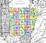
Cities, Towns, and Villages
- BridgeportBridgeport, New YorkBridgeport is a hamlet located partly in the Town of Sullivan in Madison County, New York and partly in the Town of Cicero in Onondaga County, New York...
(hamlet) - BrookfieldBrookfield, New YorkBrookfield is a town in Madison County, New York, United States. The population was 2,403 at the 2000 census.The Town of Brookfield is located in the southeast part of the county...
(town) - CanastotaCanastota, New YorkCanastota is a village located inside the Town of Lenox in Madison County, New York, United States. The population was 4,425 at the 2000 census.The Village of Canastota is in the south part of the Town of Lenox.- History :...
(village) - CazenoviaCazenovia (village), New YorkCazenovia is a village located in the Town of Cazenovia in Madison County, New York, United States. As of the 2000 census, the village had a population of 2,614. The village lies on the southeast shore of Cazenovia Lake, which is approximately long and .5 miles across...
(village) - CazenoviaCazenovia (town), New YorkCazenovia is a town in Madison County, New York, United States. The population was 6,481 at the 2000 census. The town is named after Theophilus Cazenove, an agent of the Holland Land Company.The Town of Cazenovia has a village also named Cazenovia...
(town) - ChittenangoChittenango, New YorkChittenango is a village located in Madison County, New York, in the United States. The village is in the south part of the Town of Sullivan. The population was 5,081 at the 2010 census.- History :...
(village) - DeRuyterDeRuyter (village), New YorkDeRuyter is a village located in the Town of DeRuyter in Madison County, New York, USA. The population was 531 at the 2000 census. The village and town are named after Michiel Adriaenszoon De Ruyter, a famous admiral in the Dutch navy....
(village) - DeRuyterDeRuyter (town), New YorkDeRuyter is a town in Madison County, New York, United States. The population was 1,631 at the 2000 census. The town is named after Michiel Adriaenszoon De Ruyter a famous admiral in the Dutch navy....
(town) - EarlvilleEarlville, New YorkEarlville is a village in New York, United States. The population was 791 at the 2000 census. The village is named after Jonas Earl, a canal commissioner....
(village) - EatonEaton, New YorkEaton is a town in Madison County, New York, United States. The population was 4,826 at the 2000 census.The Town of Eaton is in the south-central part of the county...
(town) - FennerFenner, New YorkFenner is a town in Madison County, New York, United States. The population was 1,680 at the 2000 census.The Town of Fenner is in the north-central part of the county...
(town) - GeorgetownGeorgetown, New YorkGeorgetown is a town in Madison County, New York, United States. The population was 946 at the 2000 census.The Town of Georgetown is on the south border of the county.- History :The town was first settled around 1804....
(town) - HamiltonHamilton (village), New YorkThe Village of Hamilton is a village located within the town of Hamilton in Madison County, New York, USA.-Geography and climate:The village, located at , lies in the Chenango Valley, just south of the headwaters of the Chenango River. The village is approximately southeast of Syracuse and ...
(village) - HamiltonHamilton (town), New YorkHamilton is a town in Madison County, New York, United States. The population was 5,733 at the 2000 census. The town is named after American patriot Alexander Hamilton....
(town) - LebanonLebanon, New YorkLebanon is a town in Madison County, New York, United States. The population was 1,329 at the 2000 census. The town is believed to be named after Lebanon, Connecticut.The Town of Lebanon is on the south border of the county.- History :...
(town) - LenoxLenox, New YorkLenox is a town in Madison County, New York, United States. The population was 8,665 as of the 2000 census.The Town of Lenox is on the county's northern border. It is west of the City of Oneida.- History :...
(town) - LincolnLincoln, New YorkLincoln is a town in Madison County, New York, United States. The population was 1,818 at the 2000 census.The Town of Lincoln is in the north-central part of the county.- History :...
(town) - MadisonMadison (village), New YorkMadison is a village in Madison County, New York, USA. The population was 315 at the 2000 census. The village and its town are named after President James Madison.The Village of Madison is in the central part of the Town of Madison on US Route 20....
(village) - MadisonMadison (town), New YorkMadison is a town in Madison County, New York, United States. The population was 2,801 at the 2000 census.The Town of Madison contains a village also named Madison. The town is on the eastern border of the county.- History :...
(town) - MorrisvilleMorrisville, New YorkMorrisville is a village in Madison County, New York, United States. The population was 2,148 at the 2000 census. The village is named after its founder, Thomas Morris.The Village of Morrisville in the northwest part of the Town of Eaton on US Route 20....
(village) - MunnsvilleMunnsville, New YorkMunnsville is a village located in the Town of Stockbridge in Madison County, New York, United States. The population was 437 at the 2000 census...
(village) - NelsonNelson, New YorkNelson is a town in Madison County, New York, United States. The population was 1,964 at the 2000 census. The town was named after Horatio Nelson, the English naval hero....
(town) - OneidaOneida, New YorkOneida is a city in Madison County located west of Oneida Castle and east of Canastota, New York, United States. The population was 10,987 at the 2000 census. The city, like both Oneida County and the nearby silver and china maker, takes its name from the Oneida tribe...
(city) - SmithfieldSmithfield, New YorkSmithfield is a town in Madison County, New York, USA. The town is named after Peter Smith, an original land owner.The Town of Smithfield is located in the center of the county.- History :The region was first settled around 1797....
(town) - StockbridgeStockbridge, New YorkStockbridge is a town in Madison County, New York, United States. The population was 2,080 at the 2000 census. The name is derived from a group of Native Americans.The Town of Stockbridge is located on the eastern border of the county.- History :...
(town) - SullivanSullivan, New YorkSullivan is a town in Madison County, New York, United States. The population was 14,991 at the 2000 census. The town is named after General John Sullivan.The Town of Sullivan is located in the northwest corner of the county.- History :...
(town) - WampsvilleWampsville, New YorkWampsville is a village located inside the Town of Lenox in Madison County, New York. The population was 561 as of the 2000 census. It is the county seat of Madison County....
(village)- Label in parentheses indicates official political level
Note: in this context "town
Town
A town is a human settlement larger than a village but smaller than a city. The size a settlement must be in order to be called a "town" varies considerably in different parts of the world, so that, for example, many American "small towns" seem to British people to be no more than villages, while...
" refers to a political subdivision synonymous with township
Township
The word township is used to refer to different kinds of settlements in different countries. Township is generally associated with an urban area. However there are many exceptions to this rule. In Australia, the United States, and Canada, they may be settlements too small to be considered urban...
rather than a small city.
The towns in southern Madison County originated from the Twenty Townships
Twenty Townships
The Twenty Townships are an area in central New York than now is largely a part of Madison and Chenango counties. The area was also known as Clinton's Purchase....
ceded by the Oneida tribe
Oneida tribe
The Oneida are a Native American/First Nations people and are one of the five founding nations of the Iroquois Confederacy in the area of upstate New York...
to the State of New York.
Adjacent counties and areas
Chenango CountyChenango County, New York
Chenango County is a county located in the U.S. state of New York. As of the 2010 census, the population was 50,477. The county's name originates from an Oneida word meaning "large bull-thistle." Its county seat is Norwich.-History:...
is across the southern border. Onondaga
Onondaga County, New York
Onondaga County is a county located in the U.S. state of New York. As of the 2010 census, the population was 467,026. The county seat is Syracuse.Onondaga County is part of the Syracuse, NY Metropolitan Statistical Area....
and Cortland
Cortland County, New York
Cortland County is a county located in the U.S. state of New York, named after Federico Van Cortlandt, president of the convention at Kingston that wrote the first New York State Constitution in 1777, and first lieutenant governor of the state. The county seat is Cortland...
Counties form the western border. Otsego County
Otsego County, New York
Otsego County is a county located in the U.S. state of New York. The 2010 population was 62,259. The county seat is Cooperstown. The name Otsego is from a Mohawk word meaning "place of the rock."-History:...
forms a short boundary in the southeast corner of Madison County. Oneida County
Oneida County, New York
Oneida County is a county located in the U.S. state of New York. As of the 2010 census, the population was 234,878. The county seat is Utica. The name is in honor of the Oneida, an Iroquoian tribe that formerly occupied the region....
shares a long northeast border with Madison County. Oneida Lake
Oneida Lake
Oneida Lake is the largest lake entirely within New York State . The lake is located northeast of Syracuse and near the Great Lakes. It serves as one of the links in the Erie Canal. It empties into the Oneida River which flows into the Oswego River which in turn flows into Lake Ontario...
is the northern border with part of Oswego County
Oswego County, New York
Oswego County is a county located in the U.S. state of New York. As of the 2010 Census, the estimated population was 122,109. The City of Oswego and the Village of Pulaski serve as the dual county seats in a two shire system of government...
on the opposite shore.
Education
- Colgate UniversityColgate UniversityColgate University is a private liberal arts college in Hamilton, New York, USA. The school was founded in 1819 as a Baptist seminary and later became non-denominational. It is named for the Colgate family who greatly contributed to the university's endowment in the 19th century.Colgate has 52...
- Cazenovia CollegeCazenovia CollegeCazenovia College is a small, independent, co-educational, baccalaureate college, located in Cazenovia, New York. Cazenovia offers a comprehensive liberal arts education with academic and co-curricular programs devoted to developing leaders in their professional fields. Cazenovia College has been...
- State University of New York at MorrisvilleState University of New York at MorrisvilleMorrisville State College, formerly the State University of New York at Morrisville or SUNY Morrisville, is a college of the State University of New York. It offers 22 bachelor degrees and a wide variety of associate degrees at two campuses in Central New York: Morrisville and Norwich...
- Brookfield Central School District
- Canastota Central School District
- Cazenovia Central School District
- Chittenango Central School District
- DeRuyter Central SchoolDeRuyter Central SchoolDeRuyter Central School is a public school district located in southwestern Madison County, New York. The school houses grades UPK-12. The current school enrollment is 491 students from the area...
- Hamilton Central School District
- Madison Central School District
- Morrisville-Eaton Central School District
- Oneida City School District
- Stockbridge Valley Central School District
See also
- List of counties in New York
- National Register of Historic Places listings in Madison County, New York