
New York State Route 41
Encyclopedia
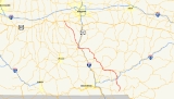
New York State Route 41 (NY 41) is a north–south state highway
in Central New York
, United States
. The southern terminus of the route is at an interchange with NY 17
in the town of Sanford
. Its northern terminus is at an intersection with U.S. Route 20 (US 20) in the village of Skaneateles
. The route is almost 100 miles (161 km) long and passes through Broome
, Chenango
, Cortland
, and Onondaga
Counties. NY 41 was assigned as part of the 1930 renumbering of state highways in New York, replacing New York State Route 70 from Homer
to Skaneateles. The route initially extended as far north as Jordan
; however, NY 41 was cut back to its current northern terminus ca. 1933.
exit 82 in McClure, a hamlet within the town of Sanford
. The route heads north, following Oquaga and Cornell Creeks through a series of valleys in the rural eastern portion of Broome County
. It intersects only minor highways of local importance before crossing into Chenango County
. Now in the town of Afton
, NY 41 passes under Interstate 88
(I-88) just south of an intersection with County Route 26 (CR 26). The highway turns northeast, paralleling I-88 into the village of Afton
.
 In Afton village, NY 41 connects to I-88 by way of an eastward extension of Maple Avenue. NY 41 turns northwest at this junction, following Maple Avenue across the Susquehanna River
and into the center of the village. Here, NY 41 briefly overlaps with NY 7
before exiting the village and heading northwestward through two more river valleys to the town of Coventry
, where it meets NY 206
in the hamlet of Coventryville.
The two routes converge here and head west to the hamlet of Coventry, where they intersect the northern end of NY 235
. NY 41 and NY 206 continue on, following Wheeler Brook westward into the town of Greene
and the village of Greene
located within. In the eastern portion of the village, the highway intersects CR 32, which joins the two state highways for two blocks before splitting off to the south at a junction on the eastern bank of the Chenango River
. NY 41 and NY 206 continue west across the river into the village center, where the two routes meet NY 12
. Here, NY 41 leaves NY 206 and follows NY 12 northward through the western portion of the village. The concurrency lasts for just 0.5 mile (0.80467 km) before NY 41 splits from NY 12 and exits Greene village.
to the hamlet of Smithville Flats, where it meets the western terminus of NY 220
. NY 41 heads northwest from this junction, passing by Long Pond and Cincinnatus Lake before crossing into Cortland County
and the town of Willet
. In the hamlet of the same name, NY 41 intersects NY 26
. It joins NY 41 here, and the two routes proceed northwest from the hamlet and across the Otselic River
to a junction with the east end of NY 221
. Past this point, Route 26 and 41 head due north along the river's west bank into the town of Cincinnatus
.
The overlap comes to an end near the hamlet of Gee Brook, where NY 41 splits from NY 26 and veers northwestward into a rural valley surrounding a small stream that gives the hamlet of Gee Brook its name. NY 41 crosses through the northeastern corner of the town of Freetown
and the southern portion of the town of Solon
on its way to the town of Cortlandville
, where it intersects I-81
and US 11 west of the village of McGraw
. US 11 and NY 41 come together here and parallel I-81 westward toward the city of Cortland
. Just east of the city line, I-81 veers north to avoid downtown Cortland while US 11 and NY 41 continue west across the Tioughnioga River
and into the city.
US 11 and NY 41 follow Port Watson Street into downtown Cortland, where they meet NY 13
at Church Street. All three routes turn north here, following Church Street for three blocks to Groton Avenue. Here, NY 13 turns east to follow Groton Avenue (which becomes Clinton Road) out of the city while US 11 and NY 41 turns west onto Groton, joining NY 222
, which begins at the junction of Groton Avenue and Church Street. Here, maintenance of the route shifts from the New York State Department of Transportation
(NYSDOT) to the city of Cortland. The overlap between NY 41 and NY 222 ends two blocks later when US 11 and NY 41 turn north onto Main Street. The two routes remain on Main Street up to Homer Avenue, at which point the two routes veer onto Homer Avenue and follow it out of the city, at which point maintenance of NY 41 becomes the responsibility of NYSDOT once more.
, US 11 and NY 41 meet I-81 once more by way of a lengthy exit ramp internally designated as NY 930Q by NYSDOT. The two routes continue on into the village center, where they meet the southern terminus of NY 90
. The overlap between US 11 and NY 41 ends three blocks later when NY 41 leaves US 11 and follows Clinton Street to the northwest. NY 41 intersects with NY 281
before leaving Homer village.
 Just over 2 miles (3.2 km) northwest of the Homer village limits in the town of Homer
, NY 41 intersects with NY 41A
, its only suffixed route. While NY 41A heads off to the west, NY 41 heads north through the town of Scott
and into the Onondaga County
town of Spafford
, where it becomes East Lake Road and begins to parallel Skaneateles Lake
. NY 41 heads northwest through Spafford, running atop a long, narrow hill bounded by Skaneateles Lake to the west and Otisco Lake
to the east. At Borodino
, a hamlet in northern Spafford, NY 41 meets the southern terminus of NY 174
. North of Borodino, NY 41 follows a more lakeside routing through the towns of Spafford and Skaneateles
to the village of Skaneateles
, where NY 41 ends at a junction with US 20
.
to the village of Homer
via the east side of Skaneateles Lake
was designated as NY 70, a numbered state highway 26 miles (42 km) long. Further south, the road leading southeast from the city of Cortland
, through Greene
at the Chenango River
, to Afton
at the Susquehanna River
(a distance of 54 miles or 87 km) was an unnumbered road. In the 1930 state highway renumbering, the entire length of old NY 70 was incorporated into the newly established NY 41. This new route was, at the time, designated from McClure (beginning at an intersection with NY 17
) through Afton and Greene to Cortland, where it met US 11. NY 41 overlapped US 11 through Cortland to Homer, from where NY 41 used old NY 70 to reach US 20 in Skaneateles. The new Route 41 continued further north to the village of Jordan
(at NY 31
). The portion of the Skaneateles–Jordan highway between Elbridge
and Jordan was previously known as NY 31A prior to 1930. When initially created in 1930, NY 41 was 112 miles (180 km) long. Ca. 1933, a pair of state routes in the vicinity of Jordan were renumbered as spur routes of NY 31. One of these was the portion of NY 41 north of Elbridge, which became NY 31C. NY 41 was truncated on its northern end to Skaneateles as part of the change. The south end of NY 41 was shifted slightly with the opening of the Quickway in 1960.
 NY 41A
(25.49 miles or 41.02 km) is a western alternate route of NY 41 which runs from Homer
to Skaneateles
along the west shore of Skaneateles Lake
. It was assigned as part of the 1930 renumbering of state highways in New York.
State highway
State highway, state road or state route can refer to one of three related concepts, two of them related to a state or provincial government in a country that is divided into states or provinces :#A...
in Central New York
Central New York
Central New York is a term used to broadly describe the central region of New York State, roughly including the following counties and cities:...
, United States
United States
The United States of America is a federal constitutional republic comprising fifty states and a federal district...
. The southern terminus of the route is at an interchange with NY 17
New York State Route 17
New York State Route 17 is a state highway that extends for through the Southern Tier and Downstate regions of New York in the United States...
in the town of Sanford
Sanford, New York
Sanford is a town in Broome County, New York, United States. The population was 2,477 at the 2000 census.The Town of Sanford is on the east border of the county and the south border of the state of New York...
. Its northern terminus is at an intersection with U.S. Route 20 (US 20) in the village of Skaneateles
Skaneateles (village), New York
Skaneateles is a village in the town of Skaneateles, Onondaga County, New York, United States. The village is named from and located on the shores of Skaneateles Lake, one of the Finger Lakes. The village, as of the 2000 census, has a population of 2,616 residents. The main highway through the...
. The route is almost 100 miles (161 km) long and passes through Broome
Broome County, New York
Broome County is a county located in the U.S. state of New York. As of the 2010 census, the population was 200,600. It was named in honor of John Broome, who was lieutenant governor in 1806 when Broome County was established. Its county seat is Binghamton, which is also its major city. The current...
, Chenango
Chenango County, New York
Chenango County is a county located in the U.S. state of New York. As of the 2010 census, the population was 50,477. The county's name originates from an Oneida word meaning "large bull-thistle." Its county seat is Norwich.-History:...
, Cortland
Cortland County, New York
Cortland County is a county located in the U.S. state of New York, named after Federico Van Cortlandt, president of the convention at Kingston that wrote the first New York State Constitution in 1777, and first lieutenant governor of the state. The county seat is Cortland...
, and Onondaga
Onondaga County, New York
Onondaga County is a county located in the U.S. state of New York. As of the 2010 census, the population was 467,026. The county seat is Syracuse.Onondaga County is part of the Syracuse, NY Metropolitan Statistical Area....
Counties. NY 41 was assigned as part of the 1930 renumbering of state highways in New York, replacing New York State Route 70 from Homer
Homer (village), New York
Homer is a village in Cortland County, New York, USA . The population was 3,368 at the 2000 census. The village name is derived from the surrounding town, which was named after the poet Homer....
to Skaneateles. The route initially extended as far north as Jordan
Jordan, New York
Jordan is a village in Onondaga County, New York, United States. The population was 1,314 at the 2000 census. It is part of the Syracuse Metropolitan Statistical Area....
; however, NY 41 was cut back to its current northern terminus ca. 1933.
Sanford to Greene
NY 41 begins at NY 17New York State Route 17
New York State Route 17 is a state highway that extends for through the Southern Tier and Downstate regions of New York in the United States...
exit 82 in McClure, a hamlet within the town of Sanford
Sanford, New York
Sanford is a town in Broome County, New York, United States. The population was 2,477 at the 2000 census.The Town of Sanford is on the east border of the county and the south border of the state of New York...
. The route heads north, following Oquaga and Cornell Creeks through a series of valleys in the rural eastern portion of Broome County
Broome County, New York
Broome County is a county located in the U.S. state of New York. As of the 2010 census, the population was 200,600. It was named in honor of John Broome, who was lieutenant governor in 1806 when Broome County was established. Its county seat is Binghamton, which is also its major city. The current...
. It intersects only minor highways of local importance before crossing into Chenango County
Chenango County, New York
Chenango County is a county located in the U.S. state of New York. As of the 2010 census, the population was 50,477. The county's name originates from an Oneida word meaning "large bull-thistle." Its county seat is Norwich.-History:...
. Now in the town of Afton
Afton (town), New York
Afton is a town in Chenango County, New York, United States. The population was 2,977 at the 2000 census. Afton is situated on the south-east corner of the county and lies wholly within the original township of Clinton...
, NY 41 passes under Interstate 88
Interstate 88 (east)
Interstate 88 is an intrastate Interstate Highway entirely within the U.S. state of New York. Its western end is at Interstate 81 in Binghamton and its eastern end is at Interstate 90 in Schenectady. It serves as an important connector route from Albany to Binghamton, Elmira , and...
(I-88) just south of an intersection with County Route 26 (CR 26). The highway turns northeast, paralleling I-88 into the village of Afton
Afton (village), New York
Afton is a village in Chenango County, New York, USA. The population was 836 at the 2000 census. The village is named after a location in Scotland.The Village of Afton is located in the Town of Afton and is northeast of Binghamton, New York....
.
Susquehanna River
The Susquehanna River is a river located in the northeastern United States. At long, it is the longest river on the American east coast that drains into the Atlantic Ocean, and with its watershed it is the 16th largest river in the United States, and the longest river in the continental United...
and into the center of the village. Here, NY 41 briefly overlaps with NY 7
New York State Route 7
New York State Route 7 is a 180-mile long New York State Highway that runs from the New York/Pennsylvania border south of Binghamton, New York to the New York/Vermont border east of Hoosick. Most of the road runs along the Susquehanna Valley, closely paralleling Interstate 88 throughout...
before exiting the village and heading northwestward through two more river valleys to the town of Coventry
Coventry, New York
Coventry is a town in Chenango County, New York, United States. The population was 1,589 at the 2000 census. The town is named after Coventry, Connecticut by settlers from New England....
, where it meets NY 206
New York State Route 206
New York State Route 206 is a state highway in the Southern Tier of New York, United States. It runs through some lightly populated regions along the state's southern border, from Central New York to the Catskills. It begins near a busy intersection with Interstate 81 at Whitney Point...
in the hamlet of Coventryville.
The two routes converge here and head west to the hamlet of Coventry, where they intersect the northern end of NY 235
New York State Route 235
New York State Route 235 is a north–south state highway in the Southern Tier of New York in the United States. Most of the route is in Chenango County; however, the southernmost is in Broome County...
. NY 41 and NY 206 continue on, following Wheeler Brook westward into the town of Greene
Greene (town), New York
Greene is a town in Chenango County, New York, United States. The population was 5,729 at the 2000 census. The town is named after General Nathanael Greene. It is located in the southwest corner of the county and contains a village, also called Greene...
and the village of Greene
Greene (village), New York
Greene is a village in Chenango County, New York, USA. The population was 1,701 at the 2000 census. The village is named after General Nathanael Greene.The Village of Greene is within the Town of Greene and is northeast of Binghamton, New York....
located within. In the eastern portion of the village, the highway intersects CR 32, which joins the two state highways for two blocks before splitting off to the south at a junction on the eastern bank of the Chenango River
Chenango River
The Chenango River is a tributary of the Susquehanna River in central New York in the United States. It drains a dissected plateau area in upstate New York at the northern end of the Susquehanna watershed....
. NY 41 and NY 206 continue west across the river into the village center, where the two routes meet NY 12
New York State Route 12
New York State Route 12 is a state highway extending for through central and northern New York in the United States. The southern terminus of the route is at U.S. Route 11 in the town of Chenango in the Southern Tier. The northern terminus is at NY 37 near the village of...
. Here, NY 41 leaves NY 206 and follows NY 12 northward through the western portion of the village. The concurrency lasts for just 0.5 mile (0.80467 km) before NY 41 splits from NY 12 and exits Greene village.
Greene to Cortland
The route continues north through the towns of Greene and SmithvilleSmithville, New York
Smithville is a town in Chenango County, New York, United States. The population was 1,347 at the 2000 census.The Town of Smithville is at the west border of Chenango County, west of the City of Norwich.- History :...
to the hamlet of Smithville Flats, where it meets the western terminus of NY 220
New York State Route 220
New York State Route 220 is a state highway located in Chenango County, New York, United States. It is signed as an east–west highway, but its actual routing wanders considerably from north to south as it proceeds across the county. The western terminus of NY 220 is at an intersection...
. NY 41 heads northwest from this junction, passing by Long Pond and Cincinnatus Lake before crossing into Cortland County
Cortland County, New York
Cortland County is a county located in the U.S. state of New York, named after Federico Van Cortlandt, president of the convention at Kingston that wrote the first New York State Constitution in 1777, and first lieutenant governor of the state. The county seat is Cortland...
and the town of Willet
Willet, New York
Willet is a town in Cortland County, New York, United States. The population was 1,011 at the 2000 census. The town is named after Colonel Marinus Willet.The Town of Willet is in the southeast part of the county, southeast of the City of Cortland....
. In the hamlet of the same name, NY 41 intersects NY 26
New York State Route 26
New York State Route 26 is a north–south state highway that runs for through Central New York in the United States. Its southern terminus is located at the Pennsylvania state line south of the town of Vestal in Broome County, where it becomes Pennsylvania Route 267...
. It joins NY 41 here, and the two routes proceed northwest from the hamlet and across the Otselic River
Otselic River
The Otselic River is a tributary of the Tioughnioga River in central New York in the United States. It drains a mountainous area, mostly forested and agricultural, east of the Finger Lakes at the northern edge of the Susquehanna River watershed....
to a junction with the east end of NY 221
New York State Route 221
New York State Route 221 is a state highway in Cortland County, New York, United States. Its western terminus is at NY 38 in the town of Harford. The eastern terminus is at NY 26 and NY 41 in the town of Willet. Near its western end, NY 221 intersects New York State...
. Past this point, Route 26 and 41 head due north along the river's west bank into the town of Cincinnatus
Cincinnatus, New York
Cincinnatus is a town in Cortland County, New York, U.S. The population was 1,051 at the 2000 census. The town is named after an important Roman general, Cincinnatus....
.
The overlap comes to an end near the hamlet of Gee Brook, where NY 41 splits from NY 26 and veers northwestward into a rural valley surrounding a small stream that gives the hamlet of Gee Brook its name. NY 41 crosses through the northeastern corner of the town of Freetown
Freetown, New York
For an area of the same name in East Hampton, New York see: Freetown Freetown is a town in Cortland County, New York, United States...
and the southern portion of the town of Solon
Solon, New York
Solon is a town in Cortland County, New York, United States. The town has a total population of 1,108, as of the 2000 census. The name of the town comes from the Greek lawmaker Solon....
on its way to the town of Cortlandville
Cortlandville, New York
Cortlandville is a town in Cortland County, New York, United States. The population was 7,919 at the 2000 census.The Town of Cortlandville surrounds the City of Cortland and is at the western border of the county.- History :...
, where it intersects I-81
Interstate 81 in New York
Interstate 81 is a part of the Interstate Highway System that runs from Dandridge, Tennessee, to the Canada – United States border at Wellesley Island in New York. In the U.S. state of New York, I-81 extends from the Pennsylvania state line southeast of Binghamton to the Canadian border...
and US 11 west of the village of McGraw
McGraw, New York
McGraw is a village in Cortland County, New York, United States. The population was 1,000 at the 2000 census. The village is named after Samuel McGraw....
. US 11 and NY 41 come together here and parallel I-81 westward toward the city of Cortland
Cortland, New York
Cortland is a city in Cortland County, New York, USA. As of the 2000 census, the city had a population of 18,740. It is the county seat of Cortland County.The City of Cortland, near the west border of the county, is surrounded by the Town of Cortlandville....
. Just east of the city line, I-81 veers north to avoid downtown Cortland while US 11 and NY 41 continue west across the Tioughnioga River
Tioughnioga River
The Tioughnioga River is a tributary of the Chenango River in central New York in the United States. It drains a dissected plateau area east of the Finger Lakes at the northernmost edge of the watershed of the Susquehanna River....
and into the city.
US 11 and NY 41 follow Port Watson Street into downtown Cortland, where they meet NY 13
New York State Route 13
New York State Route 13 is a state highway that runs mainly north–south for between NY 14 in Horseheads and NY 3 west of Pulaski in Central New York in the United States. In between, NY 13 intersects with Interstate 81 in Cortland and Pulaski and meets the New York...
at Church Street. All three routes turn north here, following Church Street for three blocks to Groton Avenue. Here, NY 13 turns east to follow Groton Avenue (which becomes Clinton Road) out of the city while US 11 and NY 41 turns west onto Groton, joining NY 222
New York State Route 222
New York State Route 222 is an east–west state highway in central New York, United States. It runs from NY 38 in the village of Groton in northeastern Tompkins County to the conjoined routes of U.S. Route 11, NY 13, and NY 41 in the city of Cortland in western Cortland...
, which begins at the junction of Groton Avenue and Church Street. Here, maintenance of the route shifts from the New York State Department of Transportation
New York State Department of Transportation
The New York State Department of Transportation is responsible for the development and operation of highways, railroads, mass transit systems, ports, waterways and aviation facilities in the U.S...
(NYSDOT) to the city of Cortland. The overlap between NY 41 and NY 222 ends two blocks later when US 11 and NY 41 turn north onto Main Street. The two routes remain on Main Street up to Homer Avenue, at which point the two routes veer onto Homer Avenue and follow it out of the city, at which point maintenance of NY 41 becomes the responsibility of NYSDOT once more.
Cortland to Skaneateles
Now in the adjacent village of HomerHomer (village), New York
Homer is a village in Cortland County, New York, USA . The population was 3,368 at the 2000 census. The village name is derived from the surrounding town, which was named after the poet Homer....
, US 11 and NY 41 meet I-81 once more by way of a lengthy exit ramp internally designated as NY 930Q by NYSDOT. The two routes continue on into the village center, where they meet the southern terminus of NY 90
New York State Route 90
New York State Route 90 is a north–south state highway in the Finger Lakes region of New York, United States. All but five of the route's are located in Cayuga County, with the remaining situated in Cortland County. The southern terminus of the route is at an intersection with U.S....
. The overlap between US 11 and NY 41 ends three blocks later when NY 41 leaves US 11 and follows Clinton Street to the northwest. NY 41 intersects with NY 281
New York State Route 281
New York State Route 281 is a north–south state highway in central New York, United States. It extends for across Cortland and Onondaga Counties. The southern terminus of the route is at an intersection with NY 13 in the town of Cortlandville. Its northern terminus is at a junction with...
before leaving Homer village.
Homer (town), New York
Homer is a town in Cortland County, New York, United States. The population was 6,363 at the 2000 census. The name is from the Greek poet Homer.The Town of Homer contains a village called Homer...
, NY 41 intersects with NY 41A
New York State Route 41A
New York State Route 41A is a north–south New York State Route located within Onondaga, Cayuga, and Cortland Counties in Central New York. Its northern terminus is located at a junction with U.S. Route 20 in the village of Skaneateles in Onondaga County...
, its only suffixed route. While NY 41A heads off to the west, NY 41 heads north through the town of Scott
Scott, New York
Scott is a town in Cortland County, New York, United States. The population was 1,193 at the 2000 census. The town was named after General Winfield Scott. The Town of Scott is on the north border of Cortland County and is northwest of the City of Cortland.- History :Scott is within the former...
and into the Onondaga County
Onondaga County, New York
Onondaga County is a county located in the U.S. state of New York. As of the 2010 census, the population was 467,026. The county seat is Syracuse.Onondaga County is part of the Syracuse, NY Metropolitan Statistical Area....
town of Spafford
Spafford, New York
Spafford is a town in Onondaga County, New York, United States. The population was 1,661 at the 2000 census. The town was named after Horatio Gates Spafford, a writer and founder of the local library....
, where it becomes East Lake Road and begins to parallel Skaneateles Lake
Skaneateles Lake
Skaneateles Lake is one of the Finger Lakes in central New York in the United States. The name Skaneateles means long lake in one of the local Iroquoian languages. The lake is sometimes referred to as "The Roof Garden of the Lakes" because its altitude is higher than the other Finger Lakes. It...
. NY 41 heads northwest through Spafford, running atop a long, narrow hill bounded by Skaneateles Lake to the west and Otisco Lake
Otisco Lake
Otisco Lake is one of the minor Finger Lakes, located at the eastern end of the Finger Lake District, southwest of Syracuse, New York.Otisco Lake is approximately six miles long. The outflow enters first Onondaga Lake via Nine Mile Creek and then Lake Ontario via the Seneca and Oswego Rivers...
to the east. At Borodino
Borodino, New York
Borodino is a hamlet located at the intersection of New York State Route 41 and New York State Route 174 in the Town of Spafford in Onondaga County, New York, near Skaneateles Lake. There is a boat launch into Skaneateles Lake for residents. There is a monument for veterans in the center of...
, a hamlet in northern Spafford, NY 41 meets the southern terminus of NY 174
New York State Route 174
New York State Route 174 is a state highway in Onondaga County, located in Central New York, United States. The highway is long and passes through mostly rural regions. Route 174 begins at an intersection with NY 41 in Borodino, a hamlet of Spafford...
. North of Borodino, NY 41 follows a more lakeside routing through the towns of Spafford and Skaneateles
Skaneateles (town), New York
Skaneateles is a town in Onondaga County, New York, United States. The population was 7,323 at the 2000 census. The name is from the Iroquois "Indian" tribe term for the adjacent lake: "long lake." The town is on the western border of the county and includes a village, also called Skaneateles...
to the village of Skaneateles
Skaneateles (village), New York
Skaneateles is a village in the town of Skaneateles, Onondaga County, New York, United States. The village is named from and located on the shores of Skaneateles Lake, one of the Finger Lakes. The village, as of the 2000 census, has a population of 2,616 residents. The main highway through the...
, where NY 41 ends at a junction with US 20
U.S. Route 20 in New York
U.S. Route 20 is a part of the U.S. Highway System that runs from Newport, Oregon, to Boston, Massachusetts. In the U.S. state of New York, US 20 extends from the Pennsylvania state line at Ripley to the Massachusetts state line in the Berkshire Mountains. US 20 is the longest...
.
History
From the mid-1920s to 1930, the road connecting the village of SkaneatelesSkaneateles (village), New York
Skaneateles is a village in the town of Skaneateles, Onondaga County, New York, United States. The village is named from and located on the shores of Skaneateles Lake, one of the Finger Lakes. The village, as of the 2000 census, has a population of 2,616 residents. The main highway through the...
to the village of Homer
Homer (village), New York
Homer is a village in Cortland County, New York, USA . The population was 3,368 at the 2000 census. The village name is derived from the surrounding town, which was named after the poet Homer....
via the east side of Skaneateles Lake
Skaneateles Lake
Skaneateles Lake is one of the Finger Lakes in central New York in the United States. The name Skaneateles means long lake in one of the local Iroquoian languages. The lake is sometimes referred to as "The Roof Garden of the Lakes" because its altitude is higher than the other Finger Lakes. It...
was designated as NY 70, a numbered state highway 26 miles (42 km) long. Further south, the road leading southeast from the city of Cortland
Cortland, New York
Cortland is a city in Cortland County, New York, USA. As of the 2000 census, the city had a population of 18,740. It is the county seat of Cortland County.The City of Cortland, near the west border of the county, is surrounded by the Town of Cortlandville....
, through Greene
Greene (village), New York
Greene is a village in Chenango County, New York, USA. The population was 1,701 at the 2000 census. The village is named after General Nathanael Greene.The Village of Greene is within the Town of Greene and is northeast of Binghamton, New York....
at the Chenango River
Chenango River
The Chenango River is a tributary of the Susquehanna River in central New York in the United States. It drains a dissected plateau area in upstate New York at the northern end of the Susquehanna watershed....
, to Afton
Afton (village), New York
Afton is a village in Chenango County, New York, USA. The population was 836 at the 2000 census. The village is named after a location in Scotland.The Village of Afton is located in the Town of Afton and is northeast of Binghamton, New York....
at the Susquehanna River
Susquehanna River
The Susquehanna River is a river located in the northeastern United States. At long, it is the longest river on the American east coast that drains into the Atlantic Ocean, and with its watershed it is the 16th largest river in the United States, and the longest river in the continental United...
(a distance of 54 miles or 87 km) was an unnumbered road. In the 1930 state highway renumbering, the entire length of old NY 70 was incorporated into the newly established NY 41. This new route was, at the time, designated from McClure (beginning at an intersection with NY 17
New York State Route 17
New York State Route 17 is a state highway that extends for through the Southern Tier and Downstate regions of New York in the United States...
) through Afton and Greene to Cortland, where it met US 11. NY 41 overlapped US 11 through Cortland to Homer, from where NY 41 used old NY 70 to reach US 20 in Skaneateles. The new Route 41 continued further north to the village of Jordan
Jordan, New York
Jordan is a village in Onondaga County, New York, United States. The population was 1,314 at the 2000 census. It is part of the Syracuse Metropolitan Statistical Area....
(at NY 31
New York State Route 31
New York State Route 31 is a state highway that extends for across western and central New York in the United States. The western terminus of the route is at an intersection with NY 104 in the city of Niagara Falls. Its eastern terminus is at a traffic circle with NY 26 in Vernon...
). The portion of the Skaneateles–Jordan highway between Elbridge
Elbridge (village), New York
The Village of Elbridge, is a village located in the western part of the Town of Elbridge and the western area of Onondaga County, New York, USA, about west of Syracuse. It is part of the Syracuse Metropolitan Statistical Area.- History :...
and Jordan was previously known as NY 31A prior to 1930. When initially created in 1930, NY 41 was 112 miles (180 km) long. Ca. 1933, a pair of state routes in the vicinity of Jordan were renumbered as spur routes of NY 31. One of these was the portion of NY 41 north of Elbridge, which became NY 31C. NY 41 was truncated on its northern end to Skaneateles as part of the change. The south end of NY 41 was shifted slightly with the opening of the Quickway in 1960.
NY 41A
New York State Route 41A
New York State Route 41A is a north–south New York State Route located within Onondaga, Cayuga, and Cortland Counties in Central New York. Its northern terminus is located at a junction with U.S. Route 20 in the village of Skaneateles in Onondaga County...
(25.49 miles or 41.02 km) is a western alternate route of NY 41 which runs from Homer
Homer (village), New York
Homer is a village in Cortland County, New York, USA . The population was 3,368 at the 2000 census. The village name is derived from the surrounding town, which was named after the poet Homer....
to Skaneateles
Skaneateles (village), New York
Skaneateles is a village in the town of Skaneateles, Onondaga County, New York, United States. The village is named from and located on the shores of Skaneateles Lake, one of the Finger Lakes. The village, as of the 2000 census, has a population of 2,616 residents. The main highway through the...
along the west shore of Skaneateles Lake
Skaneateles Lake
Skaneateles Lake is one of the Finger Lakes in central New York in the United States. The name Skaneateles means long lake in one of the local Iroquoian languages. The lake is sometimes referred to as "The Roof Garden of the Lakes" because its altitude is higher than the other Finger Lakes. It...
. It was assigned as part of the 1930 renumbering of state highways in New York.