
New York State Route 26
Encyclopedia
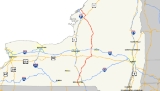
New York State Route 26 (NY 26) is a north–south state highway
that runs for 203.8 miles (327.98 km) through Central New York
in the United States. Its southern terminus is located at the Pennsylvania state line south of the town of Vestal
in Broome County
, where it becomes Pennsylvania Route 267 (PA 267). Its northern terminus is located at a junction with NY 12
in the village of Alexandria Bay
in Jefferson County
. NY 26 serves three cities along its routing; one directly (Rome
) and two via other roadways (Binghamton
via NY 17
and Watertown via NY 3
).
NY 26, as a single route, was established in the 1930 renumbering of state highways in New York; however, portions of the route had been signed state routes since the 1920s. Since 1930, the route has been realigned several times in the North Country
, resulting in a modern routing significantly different from its initial alignment.
(NYSDOT); however, two locally-maintained sections exist in Madison County
and Oneida County
. In Madison County, the route is county-maintained from NY 46
to U.S. Route 20
(US 20), where it overlaps with the unsigned
County Route 79 (CR 79). In the Oneida County city of Rome
, NY 26 is city-maintained from the north end of its overlap with NY 46 to the northern boundary of the city's inner district.
as a continuation of PA 267
, a thoroughfare in northern Pennsylvania. The road heads northward through Vestal, passing points such as Wildcat Hill (just over the state line), and Pierson Hill, in which Route 26 runs along the base of. As Route 26 heads through Vestal Center, it intersects with several Broome County routes, and passes through some hills.
 As Route 26 leaves Vestal, it crosses over Pierce Hill and connects to NY 434
and NY 17
by way of two separate interchanges. Route 26 crosses the Susquehanna River
and enters Endicott
, where it becomes concurrent with NY 17C
. Route 26 turns to the north soon after, ending the concurrency. Route 26 passes through more hills and intersects with several county routes. Just to the north, in Union Center, NY 38B terminates. Route 26 passes through the town of Maine
, intersecting with several local roads, and heads northward. Route 26 heads north, connecting to Interstate 81
by way of an interchange.
and becomes concurrent with US 11
. Route 26 enters a mountainous region again after two concurrencies (one with Route 11 and one with NY 79
). Route 26 passes to the east of Dorchester Park, which is located on the shores of the Whitney Point Reservoir. Route 26 enters Cortland County and heads along the Otselic River
.
 In the hamlet of Willet, Route 26 intersects with NY 41
, starting a 3 miles (5 km) long concurrency. Route 26 and Route 41 intersect with NY 221
just to the west of Willet. The two roads head north through mountains until a split at 42 miles (68 km). NY 23
terminates at Route 26, which heads north through Cortland County. Route 26 enters the hamlet of Taylor, New York
, where it turns to the east then to the northeast into Chenango County. At 60 miles (97 km), CR 16 becomes concurrent for a short distance. The two roads pass Otselic Center, a small hamlet in Chenango County. The concurrency ends, and Route 26 heads northeastward, where it becomes concurrent again, this time with NY 80
. During the concurrency, Routes 26 and 80 enter Madison County
.
. Route 26 heads to the northeast, passing mountains and hills to the right and left. For much of the distance of Route 26 in Madison County, Route 26 intersects with local Madison County routes. Route 26 enters the hamlet of West Eaton and turns to the west towards Oneida County at 72.3 miles (116.4 km). Just south of Bouckville, NY 46
intersects. US 20
becomes concurrent to the east of Bouckville. The concurrency stretches for five miles (8 km), with NY 12B
joining at 80.5 miles (129.6 km). Routes 26, 20 and 12B enter the village of Madison
and split in two directions. Route 20 heads east and Routes 26/12B head north. Routes 26 and 12B exits Madison County for Oneida county at 85.3 miles (137.3 km).
Routes 12B and 26 enter the village of Oriskany Falls
, where Route 26 splits to the northwest while 12B heads northward. Route 26 goes through farmland for several miles before entering Vernon Center, where NY 31
terminates at a traffic circle. About a mile north of Vernon Center, NY 5
intersects. Route 26 passes through more farmland, crossing over the New York State Thruway
. Route 26 enters the city of Rome
at 103.5 miles (166.6 km) and becomes concurrent with NY 365
. The concurrency is short, as Route 26 heads northward through more farmland after 1.8 miles (2.9 km). In downtown Rome, Routes 49 and 69 intersect with Route 26, with NY 46
coming soon after. Route 26 leaves the City of Rome as it stretches towards Lewis County
. Route 26 passes to the west of Delta Lake as it heads through Stokes Center.
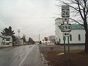 Route 26 enters Lewis County at 125.5 miles (202 km), entering the town of West Leyden. There, NY 294
begins to the east. Route 26 heads through farmlands, coming and passing through the village of Constableville
. At 137 miles (220 km), NY 12D
intersects and heads north. Route 26 heads to the northwest along the base of the Tug Hill Plateau
and passes through several hamlets as well as the village of Turin
. At 150.5 miles (242.2 km), NY 12
becomes concurrent. Routes 12 and 26 enter Lowville
and intersects with NY 812
. Route 12 turns to the west at this intersection, and Route 26 heads north along Route 812. The concurrency is short-lived, and Route 26 heads north towards Watertown. NY 410
terminates at 158.2 miles (254.6 km) in Denmark
. Shortly after the intersection with CR 55, Route 26 leaves Lewis County for Jefferson County.
 Route 26 enters West Carthage
and becomes concurrent with NY 126
. Route 126 turns to the west at 166.4 miles (267.8 km), and Route 26 leaves West Carthage for more farmland. NY 3
intersects 4 miles (6 km) north of West Carthage in the town of Great Bend
. Route 26 passes through the Fort Drum Military Reservation and intersects with CR 37. Route 26 leaves the reservation and becomes concurrent with US 11 in Le Ray
. Routes 26 and 11 pass through more farmland and rural areas until reaching the village of Philadelphia
, where the two roads split. Route 26 continues through rural land and enters the village of Theresa
at 190 miles (306 km). There, Route 26 becomes concurrent with NY 37
for three miles (5 km). Route 26 heads to the northeast, through the final stretch of farmland, coming to an end at Route 12 (Seaway Trail
) in Alexandria Bay
.
s. One route created at this time was Route 27, which began in Forestport
and followed what is now NY 12
, NY 12D
, and NY 26 north through Boonville
and Lowville
to West Carthage
. At this point, Route 27 proceeded northeast to Carthage
on modern NY 126
and west to Watertown
on current NY 3
. It continued generally northward from Watertown to a terminus in Alexandria Bay
. In 1910, the legislature established Route 30-a, a connector between Route 27 in Carthage and Route 30 (now US 11
) in Antwerp
via current NY 3 and the U.S. Military Highway through Fort Drum. On March 1, 1921, Route 30-a was redesignated as Route 49 while Route 27 was extended northeast to Ogdensburg
along what is now NY 26, CR 192, and NY 37
.
When the first set of posted routes in New York
were assigned in 1924, the segment of legislative Route 27 between Alexandria Bay and Ogdensburg became part of NY 3 while the portion of Route 27 from Foresport to Lowville was included in NY 12. By 1926, the Lowville–Carthage section of legislative Route 27 and all of Route 49 was designated as part of NY 48, which continued west from Antwerp to NY 3 in Alexandria
on what is now CR 193, CR 194 and NY 26. Also created by 1926 was NY 46
, which began in Oriskany Falls
and went north to Rome
on modern NY 26. Past Rome, NY 46 followed its current alignment to Boonville. The portion of what is now NY 26 south of US 20
was unnumbered prior to 1930.
and went north to Carthage over its modern alignment. From Oriskany Falls to Rome, it replaced NY 46, which was moved onto a new alignment to the west that passed through the city of Oneida
. NY 26 continued north to Turin
via a previously unnumbered road and overlapped with NY 12 from there to Lowville. Past Lowville, NY 26 progressed northward through Carthage, Antwerp and Theresa
to Alexandria Bay, replacing all of NY 48 and part of NY 3, which was realigned to follow its modern alignment east of Watertown as part of the renumbering. Also assigned as part of the renumbering was NY 411
, a connector highway between NY 26 near Theresa and US 11 in Philadelphia
.
NY 26 was realigned in the mid-1950s to bypass Fort Drum to the west. The route now overlapped NY 3 northwest and west from Carthage to Black River
, where it turned northwest to follow a surface road known as the Watertown Bypass to Calcium
. NY 26 joined US 11 at a junction north of Calcium and followed it northwest to Antwerp, where it joined its previous alignment. The state of New York
assumed ownership and maintenance of the bypass in 1960, at which time it was designated as NY 181. The easternmost section of the highway was realigned ca. 1963 to bypass Black River to the west. It separated from NY 3 west of Black River and followed the Black River
north to Pearl Street, where it met its old routing. NY 181, which NY 26 overlapped between Calcium and Black River, was renumbered to NY 342
around this time.
west of the village were transferred from the state of New York to Jefferson County
as part of a highway maintenance swap between the two levels of government. As part of the swap, maintenance of LaFargeville Road from NY 37 to NY 283 and of Broad and Martin Streets, Great Bend and Fort Drum Roads between West Carthage
and Evans Mills were transferred from the county to the state.
Following the swap, NY 26 was rerouted to follow the new state highway between West Carthage and Evans Mills. It then overlapped US 11 to Philadelphia, where it continued to Theresa on former NY 411. It exited Theresa on LaFargeville Road, then followed NY 37 north to Wilson Road, where it rejoined its pre-1970s alignment and continued to Alexandria Bay. The former routing of NY 26 between Fort Drum and Theresa via Antwerp (and thus the former alignment of NY 283 between Antwerp and Theresa) became CR 194 while the former part of NY 26 and NY 283 west of Theresa became CR 193.
State highway
State highway, state road or state route can refer to one of three related concepts, two of them related to a state or provincial government in a country that is divided into states or provinces :#A...
that runs for 203.8 miles (327.98 km) through Central New York
Central New York
Central New York is a term used to broadly describe the central region of New York State, roughly including the following counties and cities:...
in the United States. Its southern terminus is located at the Pennsylvania state line south of the town of Vestal
Vestal, New York
Vestal is a town within Broome County in the Southern Tier of New York, and lies between the Susquehanna River and the Pennsylvania border. As of the 2000 census, the population was 26,535, estimated to have grown to 27,369 in 2009....
in Broome County
Broome County, New York
Broome County is a county located in the U.S. state of New York. As of the 2010 census, the population was 200,600. It was named in honor of John Broome, who was lieutenant governor in 1806 when Broome County was established. Its county seat is Binghamton, which is also its major city. The current...
, where it becomes Pennsylvania Route 267 (PA 267). Its northern terminus is located at a junction with NY 12
New York State Route 12
New York State Route 12 is a state highway extending for through central and northern New York in the United States. The southern terminus of the route is at U.S. Route 11 in the town of Chenango in the Southern Tier. The northern terminus is at NY 37 near the village of...
in the village of Alexandria Bay
Alexandria Bay, New York
Alexandria Bay is a village in Jefferson County, New York, United States. The population was 1,080 at the 2010 census.The Village of Alexandria Bay is in the Town of Alexandria.Keewaydin State Park is southeast of the village...
in Jefferson County
Jefferson County, New York
Jefferson County is a county located in the U.S. state of New York. As of the 2010 census, the population was 116,229. It is named after Thomas Jefferson, third President of the United States of America, and president at the time the county was created in 1805...
. NY 26 serves three cities along its routing; one directly (Rome
Rome, New York
Rome is a city in Oneida County, New York, United States. It is located in north-central or "upstate" New York. The population was 44,797 at the 2010 census. It is in New York's 24th congressional district. In 1758, British forces began construction of Fort Stanwix at this strategic location, but...
) and two via other roadways (Binghamton
Binghamton, New York
Binghamton is a city in the Southern Tier of New York in the United States. It is near the Pennsylvania border, in a bowl-shaped valley at the confluence of the Susquehanna and Chenango Rivers...
via NY 17
New York State Route 17
New York State Route 17 is a state highway that extends for through the Southern Tier and Downstate regions of New York in the United States...
and Watertown via NY 3
New York State Route 3
New York State Route 3 is a major east–west state highway in New York, United States, that connects central New York to the North Country region near the Canadian border via Adirondack Park. The route extends for between its western terminus at an intersection with NY 104A in the Cayuga...
).
NY 26, as a single route, was established in the 1930 renumbering of state highways in New York; however, portions of the route had been signed state routes since the 1920s. Since 1930, the route has been realigned several times in the North Country
North Country, New York
The North Country is a region of the U.S. state of New York that encompasses the state's extreme northern frontier, bordering Lake Ontario on the west, the Saint Lawrence River and the Canadian provinces of Ontario and Quebec on the north and northwest, and Lake Champlain and Vermont on the east...
, resulting in a modern routing significantly different from its initial alignment.
Route description
Most of NY 26 is maintained by the New York State Department of TransportationNew York State Department of Transportation
The New York State Department of Transportation is responsible for the development and operation of highways, railroads, mass transit systems, ports, waterways and aviation facilities in the U.S...
(NYSDOT); however, two locally-maintained sections exist in Madison County
Madison County, New York
Madison County is a county located in the U.S. state of New York. As of the 2010 census, the population was 73,442. It is named after James Madison, fourth President of the United States of America...
and Oneida County
Oneida County, New York
Oneida County is a county located in the U.S. state of New York. As of the 2010 census, the population was 234,878. The county seat is Utica. The name is in honor of the Oneida, an Iroquoian tribe that formerly occupied the region....
. In Madison County, the route is county-maintained from NY 46
New York State Route 46
New York State Route 46 is a state highway in Central New York, United States. It extends from NY 12B in the Madison County town of Eaton to NY 12D in the Oneida County village of Boonville. NY 46 passes through the cities of Oneida and Rome.-Madison County:NY 46 begins at...
to U.S. Route 20
U.S. Route 20 in New York
U.S. Route 20 is a part of the U.S. Highway System that runs from Newport, Oregon, to Boston, Massachusetts. In the U.S. state of New York, US 20 extends from the Pennsylvania state line at Ripley to the Massachusetts state line in the Berkshire Mountains. US 20 is the longest...
(US 20), where it overlaps with the unsigned
Unsigned highway
An unsigned highway is a highway that has been assigned a route number, but does not bear conventional road markings that would normally be used to identify the route with that number...
County Route 79 (CR 79). In the Oneida County city of Rome
Rome, New York
Rome is a city in Oneida County, New York, United States. It is located in north-central or "upstate" New York. The population was 44,797 at the 2010 census. It is in New York's 24th congressional district. In 1758, British forces began construction of Fort Stanwix at this strategic location, but...
, NY 26 is city-maintained from the north end of its overlap with NY 46 to the northern boundary of the city's inner district.
Broome County
Route 26 begins at the Pennsylvania state line in VestalVestal, New York
Vestal is a town within Broome County in the Southern Tier of New York, and lies between the Susquehanna River and the Pennsylvania border. As of the 2000 census, the population was 26,535, estimated to have grown to 27,369 in 2009....
as a continuation of PA 267
Pennsylvania Route 267
Pennsylvania Route 267 is a long state highway located in Wyoming and Susquehanna counties in Pennsylvania. The southern terminus is at US 6 in Meshoppen. The northern terminus is the New York state line in Choconut Township....
, a thoroughfare in northern Pennsylvania. The road heads northward through Vestal, passing points such as Wildcat Hill (just over the state line), and Pierson Hill, in which Route 26 runs along the base of. As Route 26 heads through Vestal Center, it intersects with several Broome County routes, and passes through some hills.
New York State Route 434
New York State Route 434 is a state highway located in the Southern Tier of the U.S. state of New York. The route extends for from an intersection with NY 96 in the village of Owego to an intersection with US 11 in the city of Binghamton. In between, NY 434 passes through the...
and NY 17
New York State Route 17
New York State Route 17 is a state highway that extends for through the Southern Tier and Downstate regions of New York in the United States...
by way of two separate interchanges. Route 26 crosses the Susquehanna River
Susquehanna River
The Susquehanna River is a river located in the northeastern United States. At long, it is the longest river on the American east coast that drains into the Atlantic Ocean, and with its watershed it is the 16th largest river in the United States, and the longest river in the continental United...
and enters Endicott
Endicott, New York
Endicott is a village in Broome County, New York, United States. The population was 13,038 at the 2000 census. It is part of the Binghamton Metropolitan Statistical Area. The village is named after Henry B...
, where it becomes concurrent with NY 17C
New York State Route 17C
New York State Route 17C is a state highway in the Southern Tier of New York. Its western terminus is at an intersection with NY 34 in Waverly, Tioga County while its eastern terminus is at an intersection with U.S. Route 11 in Binghamton, Broome County...
. Route 26 turns to the north soon after, ending the concurrency. Route 26 passes through more hills and intersects with several county routes. Just to the north, in Union Center, NY 38B terminates. Route 26 passes through the town of Maine
Maine, New York
Maine is a town in Broome County, New York, United States. The population was 5,459 at the 2000 census.The Town of Maine is on the western border of the county and is northwest of Binghamton.Maine is home to the Greater Binghamton Airport...
, intersecting with several local roads, and heads northward. Route 26 heads north, connecting to Interstate 81
Interstate 81 in New York
Interstate 81 is a part of the Interstate Highway System that runs from Dandridge, Tennessee, to the Canada – United States border at Wellesley Island in New York. In the U.S. state of New York, I-81 extends from the Pennsylvania state line southeast of Binghamton to the Canadian border...
by way of an interchange.
Cortland and Chenango Counties
Route 26 enters Whitney PointWhitney Point, New York
Whitney Point is a village in Broome County, New York, United States. The population was 965 at the 2000 census. It is part of the Binghamton Metropolitan Statistical Area...
and becomes concurrent with US 11
U.S. Route 11 in New York
U.S. Route 11 is a part of the U.S. Highway System that runs from New Orleans, Louisiana, to the Canadian border at Rouses Point, New York...
. Route 26 enters a mountainous region again after two concurrencies (one with Route 11 and one with NY 79
New York State Route 79
New York State Route 79 is an east–west state highway in the Southern Tier of New York, United States. The western terminus of the route is at the intersection with NY 414 near the southern end of Seneca Lake east of Watkins Glen...
). Route 26 passes to the east of Dorchester Park, which is located on the shores of the Whitney Point Reservoir. Route 26 enters Cortland County and heads along the Otselic River
Otselic River
The Otselic River is a tributary of the Tioughnioga River in central New York in the United States. It drains a mountainous area, mostly forested and agricultural, east of the Finger Lakes at the northern edge of the Susquehanna River watershed....
.
New York State Route 41
New York State Route 41 is a north–south state highway in Central New York, United States. The southern terminus of the route is at an interchange with NY 17 in the town of Sanford. Its northern terminus is at an intersection with U.S. Route 20 in the village of Skaneateles...
, starting a 3 miles (5 km) long concurrency. Route 26 and Route 41 intersect with NY 221
New York State Route 221
New York State Route 221 is a state highway in Cortland County, New York, United States. Its western terminus is at NY 38 in the town of Harford. The eastern terminus is at NY 26 and NY 41 in the town of Willet. Near its western end, NY 221 intersects New York State...
just to the west of Willet. The two roads head north through mountains until a split at 42 miles (68 km). NY 23
New York State Route 23
New York State Route 23 is an east–west state highway in the eastern portion New York in the United States. It extends for from an intersection with NY 26 in the Central New York town of Cincinnatus to the Massachusetts state line in the Berkshire Mountains, where it continues east as...
terminates at Route 26, which heads north through Cortland County. Route 26 enters the hamlet of Taylor, New York
Taylor, New York
Taylor is a town in Cortland County, New York, United States. The town is in the eastern part of the county and is east of the City of Cortland. The population was 500 at the 2000 census. The town is named after General Zachary Taylor.- History :...
, where it turns to the east then to the northeast into Chenango County. At 60 miles (97 km), CR 16 becomes concurrent for a short distance. The two roads pass Otselic Center, a small hamlet in Chenango County. The concurrency ends, and Route 26 heads northeastward, where it becomes concurrent again, this time with NY 80
New York State Route 80
New York State Route 80 is a west–east New York State Route located within Onondaga, Madison, Chenango, Otsego, Herkimer, and Montgomery Counties in New York. Its western terminus is located at a junction with NY 175 in the city of Syracuse in Onondaga County, from which it...
. During the concurrency, Routes 26 and 80 enter Madison County
Madison County, New York
Madison County is a county located in the U.S. state of New York. As of the 2010 census, the population was 73,442. It is named after James Madison, fourth President of the United States of America...
.
Madison and Oneida Counties
Routes 26 and 80 split in the hamlet of GeorgetownGeorgetown, New York
Georgetown is a town in Madison County, New York, United States. The population was 946 at the 2000 census.The Town of Georgetown is on the south border of the county.- History :The town was first settled around 1804....
. Route 26 heads to the northeast, passing mountains and hills to the right and left. For much of the distance of Route 26 in Madison County, Route 26 intersects with local Madison County routes. Route 26 enters the hamlet of West Eaton and turns to the west towards Oneida County at 72.3 miles (116.4 km). Just south of Bouckville, NY 46
New York State Route 46
New York State Route 46 is a state highway in Central New York, United States. It extends from NY 12B in the Madison County town of Eaton to NY 12D in the Oneida County village of Boonville. NY 46 passes through the cities of Oneida and Rome.-Madison County:NY 46 begins at...
intersects. US 20
U.S. Route 20 in New York
U.S. Route 20 is a part of the U.S. Highway System that runs from Newport, Oregon, to Boston, Massachusetts. In the U.S. state of New York, US 20 extends from the Pennsylvania state line at Ripley to the Massachusetts state line in the Berkshire Mountains. US 20 is the longest...
becomes concurrent to the east of Bouckville. The concurrency stretches for five miles (8 km), with NY 12B
New York State Route 12B
New York State Route 12B is a state highway in the central part of New York, United States. NY 12B is a north–south highway connecting Oneida County in the north to Chenango County in the south, passing through Madison County in between. The southern terminus of NY 12B is at...
joining at 80.5 miles (129.6 km). Routes 26, 20 and 12B enter the village of Madison
Madison (village), New York
Madison is a village in Madison County, New York, USA. The population was 315 at the 2000 census. The village and its town are named after President James Madison.The Village of Madison is in the central part of the Town of Madison on US Route 20....
and split in two directions. Route 20 heads east and Routes 26/12B head north. Routes 26 and 12B exits Madison County for Oneida county at 85.3 miles (137.3 km).
Routes 12B and 26 enter the village of Oriskany Falls
Oriskany Falls, New York
Oriskany Falls is a village in Oneida County, New York in the United States. The population was 698 at the 2000 census. The name is derived from a waterfall on a nearby stream....
, where Route 26 splits to the northwest while 12B heads northward. Route 26 goes through farmland for several miles before entering Vernon Center, where NY 31
New York State Route 31
New York State Route 31 is a state highway that extends for across western and central New York in the United States. The western terminus of the route is at an intersection with NY 104 in the city of Niagara Falls. Its eastern terminus is at a traffic circle with NY 26 in Vernon...
terminates at a traffic circle. About a mile north of Vernon Center, NY 5
New York State Route 5
New York State Route 5 is a state highway that extends for across the state of New York in the United States. It begins at the Pennsylvania state line in the Chautauqua County town of Ripley and passes through Buffalo, Syracuse, Utica, Schenectady, and several other smaller cities and...
intersects. Route 26 passes through more farmland, crossing over the New York State Thruway
New York State Thruway
The New York State Thruway is a system of limited-access highways located within the state of New York in the United States. The system, known officially as the Governor Thomas E. Dewey Thruway for former New York Governor Thomas E. Dewey, is operated by the New York State Thruway Authority and...
. Route 26 enters the city of Rome
Rome, New York
Rome is a city in Oneida County, New York, United States. It is located in north-central or "upstate" New York. The population was 44,797 at the 2010 census. It is in New York's 24th congressional district. In 1758, British forces began construction of Fort Stanwix at this strategic location, but...
at 103.5 miles (166.6 km) and becomes concurrent with NY 365
New York State Route 365
New York State Route 365 is an east–west state highway in the central portion of New York in the United States. It extends for from an intersection with NY 5 east of the Oneida County city of Oneida to a junction with NY 8 in the Herkimer County town of Ohio...
. The concurrency is short, as Route 26 heads northward through more farmland after 1.8 miles (2.9 km). In downtown Rome, Routes 49 and 69 intersect with Route 26, with NY 46
New York State Route 46
New York State Route 46 is a state highway in Central New York, United States. It extends from NY 12B in the Madison County town of Eaton to NY 12D in the Oneida County village of Boonville. NY 46 passes through the cities of Oneida and Rome.-Madison County:NY 46 begins at...
coming soon after. Route 26 leaves the City of Rome as it stretches towards Lewis County
Lewis County, New York
As of the census of 2000, there were 26,944 people, 10,040 households, and 7,309 families residing in the county. The population density was 21 people per square mile . There were 15,134 housing units at an average density of 12 per square mile...
. Route 26 passes to the west of Delta Lake as it heads through Stokes Center.
Lewis and Jefferson Counties
New York State Route 294
New York State Route 294 is a state highway in northern New York state. This highway is an east–west route between the Town of Lewis in Lewis County and the Village of Boonville in Oneida County....
begins to the east. Route 26 heads through farmlands, coming and passing through the village of Constableville
Constableville, New York
Constableville is a village in Lewis County, New York, United States. The population was 305 at the 2000 census. The village is named after William Constable, the son of an early landowner....
. At 137 miles (220 km), NY 12D
New York State Route 12D
New York State Route 12D is a north–south state highway located in the northern part of New York, United States. The southern terminus of the route is in the Oneida County village of Boonville, where it intersects NY 12. The northern terminus is at a junction with NY 12 in the Lewis...
intersects and heads north. Route 26 heads to the northwest along the base of the Tug Hill Plateau
Tug Hill Plateau
The Tug Hill Plateau is an upland region in upstate New York in the USA, famous for heavy winter snow. The Tug Hill Region is west of the Adirondack Mountains and is separated from the Adirondacks by the Black River Valley. Although the region is and has traditionally been known as the Tug Hill...
and passes through several hamlets as well as the village of Turin
Turin (village), New York
Turin is a village in Lewis County, New York, in the United States. The village is within the town of Turin and is north of the city of Rome. As of the 2000 census, the village population was 263.- History :...
. At 150.5 miles (242.2 km), NY 12
New York State Route 12
New York State Route 12 is a state highway extending for through central and northern New York in the United States. The southern terminus of the route is at U.S. Route 11 in the town of Chenango in the Southern Tier. The northern terminus is at NY 37 near the village of...
becomes concurrent. Routes 12 and 26 enter Lowville
Lowville (village), New York
Lowville is a village in Lewis County, New York, United States. The Village is nestled in the Black River Valley, between the foothills of the Adirondack Mountains and the Tug Hill Plateau, and is located in the eastern part of the Town of Lowville....
and intersects with NY 812
New York State Route 812
New York State Route 812 is a state highway in the North Country of New York in the United States. The southern terminus of the route is at an intersection with NY 12 and NY 26 in the Lewis County village of Lowville...
. Route 12 turns to the west at this intersection, and Route 26 heads north along Route 812. The concurrency is short-lived, and Route 26 heads north towards Watertown. NY 410
New York State Route 410
New York State Route 410 is a state highway in Lewis County, New York, United States, that serves as a connector between NY 26, NY 126, and the village of Castorland.-Route description:...
terminates at 158.2 miles (254.6 km) in Denmark
Denmark, New York
Denmark is a town in Lewis County, New York, United States named after the Kingdom of Denmark, situated in Scandinavia. The population was 2,747 at the 2000 census.The Town of Denmark is on the northwest border of the county and is east of Watertown....
. Shortly after the intersection with CR 55, Route 26 leaves Lewis County for Jefferson County.
West Carthage, New York
West Carthage is a village in Jefferson County, New York, United States. The population was 2,102 at the 2000 census.The Village of West Carthage is in the Town of Champion. The village is the east town line, and is east of Watertown...
and becomes concurrent with NY 126
New York State Route 126
New York State Route 126 is a state highway in the North Country of New York in the United States. It proceeds in a roughly northwest to southeast direction between NY 12 at the eastern city line of Watertown in central Jefferson County and NY 812 in the village of Croghan in...
. Route 126 turns to the west at 166.4 miles (267.8 km), and Route 26 leaves West Carthage for more farmland. NY 3
New York State Route 3
New York State Route 3 is a major east–west state highway in New York, United States, that connects central New York to the North Country region near the Canadian border via Adirondack Park. The route extends for between its western terminus at an intersection with NY 104A in the Cayuga...
intersects 4 miles (6 km) north of West Carthage in the town of Great Bend
Great Bend, New York
Great Bend is a hamlet in Jefferson County, New York, United States. The population was 801 at the 2000 census.Great Bend is in the northern part of the Town of Champion...
. Route 26 passes through the Fort Drum Military Reservation and intersects with CR 37. Route 26 leaves the reservation and becomes concurrent with US 11 in Le Ray
Le Ray, New York
Le Ray is a town in Jefferson County, New York, United States. The population was 21,782 at the 2010 census. The town is named for Jacques-Donatien Le Ray, from France.The Town of Le Ray is in the central part of the county and is east of Watertown....
. Routes 26 and 11 pass through more farmland and rural areas until reaching the village of Philadelphia
Philadelphia (village), New York
Philadelphia is a village in Jefferson County, New York, United States. The population was 1,519 at the 2000 census.The Village of Philadelphia is in the Town of Philadelphia and is northeast of Watertown...
, where the two roads split. Route 26 continues through rural land and enters the village of Theresa
Theresa (village), New York
Theresa is a village located in the Town of Theresa in Jefferson County, New York, USA. The population was 812 at the 2000 census.The Village of Theresa is northeast of Watertown.- History :...
at 190 miles (306 km). There, Route 26 becomes concurrent with NY 37
New York State Route 37
New York State Route 37 is a state highway in the North Country of New York in the United States, extending for on a west–east axis. The western terminus of the route is at an intersection with U.S. Route 11 in Watertown, Jefferson County...
for three miles (5 km). Route 26 heads to the northeast, through the final stretch of farmland, coming to an end at Route 12 (Seaway Trail
Seaway Trail
The Great Lakes Seaway Trail, formerly named and commonly known as the Seaway Trail, is a National Scenic Byway in the northeastern United States, mostly contained in New York but with a small segment in Pennsylvania...
) in Alexandria Bay
Alexandria Bay, New York
Alexandria Bay is a village in Jefferson County, New York, United States. The population was 1,080 at the 2010 census.The Village of Alexandria Bay is in the Town of Alexandria.Keewaydin State Park is southeast of the village...
.
Origins
In 1908, the New York State Legislature created a statewide system of unsigned legislative routeLegislative route
In United States, a legislative route or legislative highway is a highway defined by laws passed in a state legislature. The numbering of such highways may or may not correspond to the numbers familiar to the public as part of the state, U.S. highway, and Interstate highway systems...
s. One route created at this time was Route 27, which began in Forestport
Forestport, New York
Forestport is a town in Oneida County, New York, United States. The population was 1,692 at the 2000 census.The Town of Forestport is located in the northeast corner of Oneida County...
and followed what is now NY 12
New York State Route 12
New York State Route 12 is a state highway extending for through central and northern New York in the United States. The southern terminus of the route is at U.S. Route 11 in the town of Chenango in the Southern Tier. The northern terminus is at NY 37 near the village of...
, NY 12D
New York State Route 12D
New York State Route 12D is a north–south state highway located in the northern part of New York, United States. The southern terminus of the route is in the Oneida County village of Boonville, where it intersects NY 12. The northern terminus is at a junction with NY 12 in the Lewis...
, and NY 26 north through Boonville
Boonville (village), New York
This page is about the village in New York. For other communities of the same name, see Boonville or for the town, see Boonville , New York...
and Lowville
Lowville (village), New York
Lowville is a village in Lewis County, New York, United States. The Village is nestled in the Black River Valley, between the foothills of the Adirondack Mountains and the Tug Hill Plateau, and is located in the eastern part of the Town of Lowville....
to West Carthage
West Carthage, New York
West Carthage is a village in Jefferson County, New York, United States. The population was 2,102 at the 2000 census.The Village of West Carthage is in the Town of Champion. The village is the east town line, and is east of Watertown...
. At this point, Route 27 proceeded northeast to Carthage
Carthage, New York
Carthage is a village located in the Town of Wilna in Jefferson County, New York. The population was 3,721 at the 2000 census. The village is named after the historic Carthage in North Africa....
on modern NY 126
New York State Route 126
New York State Route 126 is a state highway in the North Country of New York in the United States. It proceeds in a roughly northwest to southeast direction between NY 12 at the eastern city line of Watertown in central Jefferson County and NY 812 in the village of Croghan in...
and west to Watertown
Watertown (city), New York
Watertown is a city in the state of New York and the county seat of Jefferson County. It is situated approximately south of the Thousand Islands. As of the 2010 census, it had a population of 27,023, an increase of 1.2% since 2000. The U.S...
on current NY 3
New York State Route 3
New York State Route 3 is a major east–west state highway in New York, United States, that connects central New York to the North Country region near the Canadian border via Adirondack Park. The route extends for between its western terminus at an intersection with NY 104A in the Cayuga...
. It continued generally northward from Watertown to a terminus in Alexandria Bay
Alexandria Bay, New York
Alexandria Bay is a village in Jefferson County, New York, United States. The population was 1,080 at the 2010 census.The Village of Alexandria Bay is in the Town of Alexandria.Keewaydin State Park is southeast of the village...
. In 1910, the legislature established Route 30-a, a connector between Route 27 in Carthage and Route 30 (now US 11
U.S. Route 11 in New York
U.S. Route 11 is a part of the U.S. Highway System that runs from New Orleans, Louisiana, to the Canadian border at Rouses Point, New York...
) in Antwerp
Antwerp (village), New York
Antwerp is a village in Jefferson County, New York, United States. The population was 716 at the 2000 census.The Village of Antwerp is in center of the Town of Antwerp and is northwest of Watertown.- History :...
via current NY 3 and the U.S. Military Highway through Fort Drum. On March 1, 1921, Route 30-a was redesignated as Route 49 while Route 27 was extended northeast to Ogdensburg
Ogdensburg, New York
Ogdensburg is a city in St. Lawrence County, New York, United States. The population was 11,128 at the 2010 census. In the late 18th century, European-American settlers named the community after American land owner and developer Samuel Ogden....
along what is now NY 26, CR 192, and NY 37
New York State Route 37
New York State Route 37 is a state highway in the North Country of New York in the United States, extending for on a west–east axis. The western terminus of the route is at an intersection with U.S. Route 11 in Watertown, Jefferson County...
.
When the first set of posted routes in New York
New York
New York is a state in the Northeastern region of the United States. It is the nation's third most populous state. New York is bordered by New Jersey and Pennsylvania to the south, and by Connecticut, Massachusetts and Vermont to the east...
were assigned in 1924, the segment of legislative Route 27 between Alexandria Bay and Ogdensburg became part of NY 3 while the portion of Route 27 from Foresport to Lowville was included in NY 12. By 1926, the Lowville–Carthage section of legislative Route 27 and all of Route 49 was designated as part of NY 48, which continued west from Antwerp to NY 3 in Alexandria
Alexandria, New York
Alexandria is a town in Jefferson County, United States. New York, USA. The population was 4,061 at the 2010 census. The town is named after Alexander LeRay, the son of an early developer....
on what is now CR 193, CR 194 and NY 26. Also created by 1926 was NY 46
New York State Route 46
New York State Route 46 is a state highway in Central New York, United States. It extends from NY 12B in the Madison County town of Eaton to NY 12D in the Oneida County village of Boonville. NY 46 passes through the cities of Oneida and Rome.-Madison County:NY 46 begins at...
, which began in Oriskany Falls
Oriskany Falls, New York
Oriskany Falls is a village in Oneida County, New York in the United States. The population was 698 at the 2000 census. The name is derived from a waterfall on a nearby stream....
and went north to Rome
Rome, New York
Rome is a city in Oneida County, New York, United States. It is located in north-central or "upstate" New York. The population was 44,797 at the 2010 census. It is in New York's 24th congressional district. In 1758, British forces began construction of Fort Stanwix at this strategic location, but...
on modern NY 26. Past Rome, NY 46 followed its current alignment to Boonville. The portion of what is now NY 26 south of US 20
U.S. Route 20 in New York
U.S. Route 20 is a part of the U.S. Highway System that runs from Newport, Oregon, to Boston, Massachusetts. In the U.S. state of New York, US 20 extends from the Pennsylvania state line at Ripley to the Massachusetts state line in the Berkshire Mountains. US 20 is the longest...
was unnumbered prior to 1930.
Designation and realignments
Modern NY 26 was established as part of the 1930 renumbering of state highways in New York. It began at the Pennsylvania state line south of EndicottEndicott, New York
Endicott is a village in Broome County, New York, United States. The population was 13,038 at the 2000 census. It is part of the Binghamton Metropolitan Statistical Area. The village is named after Henry B...
and went north to Carthage over its modern alignment. From Oriskany Falls to Rome, it replaced NY 46, which was moved onto a new alignment to the west that passed through the city of Oneida
Oneida, New York
Oneida is a city in Madison County located west of Oneida Castle and east of Canastota, New York, United States. The population was 10,987 at the 2000 census. The city, like both Oneida County and the nearby silver and china maker, takes its name from the Oneida tribe...
. NY 26 continued north to Turin
Turin (village), New York
Turin is a village in Lewis County, New York, in the United States. The village is within the town of Turin and is north of the city of Rome. As of the 2000 census, the village population was 263.- History :...
via a previously unnumbered road and overlapped with NY 12 from there to Lowville. Past Lowville, NY 26 progressed northward through Carthage, Antwerp and Theresa
Theresa (village), New York
Theresa is a village located in the Town of Theresa in Jefferson County, New York, USA. The population was 812 at the 2000 census.The Village of Theresa is northeast of Watertown.- History :...
to Alexandria Bay, replacing all of NY 48 and part of NY 3, which was realigned to follow its modern alignment east of Watertown as part of the renumbering. Also assigned as part of the renumbering was NY 411
New York State Route 411
New York State Route 411 is an east–west state highway in Jefferson County, New York, United States. The western terminus of the route is at an intersection with NY 180 in the community of La Fargeville in the town of Orleans...
, a connector highway between NY 26 near Theresa and US 11 in Philadelphia
Philadelphia (village), New York
Philadelphia is a village in Jefferson County, New York, United States. The population was 1,519 at the 2000 census.The Village of Philadelphia is in the Town of Philadelphia and is northeast of Watertown...
.
NY 26 was realigned in the mid-1950s to bypass Fort Drum to the west. The route now overlapped NY 3 northwest and west from Carthage to Black River
Black River, New York
Black River is a village in Jefferson County, New York, United States. The population was 1,285 at the 2000 census.The Village of Black River is on the border of the Town of Le Ray and the Town of Rutland...
, where it turned northwest to follow a surface road known as the Watertown Bypass to Calcium
Calcium, New York
Calcium is a hamlet in Jefferson County, New York, United States. The population was 3,516 as of July 2007.Calcium is in the Town of Le Ray and was formerly called Sanford's Corner....
. NY 26 joined US 11 at a junction north of Calcium and followed it northwest to Antwerp, where it joined its previous alignment. The state of New York
New York
New York is a state in the Northeastern region of the United States. It is the nation's third most populous state. New York is bordered by New Jersey and Pennsylvania to the south, and by Connecticut, Massachusetts and Vermont to the east...
assumed ownership and maintenance of the bypass in 1960, at which time it was designated as NY 181. The easternmost section of the highway was realigned ca. 1963 to bypass Black River to the west. It separated from NY 3 west of Black River and followed the Black River
Black River (New York)
The Black River is a blackwater river that empties into the eastern end of Lake Ontario on the shore of Jefferson County, New York in the United States of America...
north to Pearl Street, where it met its old routing. NY 181, which NY 26 overlapped between Calcium and Black River, was renumbered to NY 342
New York State Route 342
New York State Route 342 is a short east–west state highway in Jefferson County, New York, United States. The western terminus of NY 342 is at an intersection with NY 12 near the hamlet of Scoville Corners in the town of Pamelia. The eastern terminus is at a junction with...
around this time.
Truncation and re-extension
NY 26 was truncated in the mid-1970s to end at NY 3 and NY 26A in Carthage. The former routing of NY 26 from Antwerp to Alexandria Bay was then redesignated as NY 283. On August 1, 1979, ownership and maintenance of the portions of NY 283 from US 11 in Antwerp to NY 411 in Theresa and from LaFargeville Road in Theresa to NY 37New York State Route 37
New York State Route 37 is a state highway in the North Country of New York in the United States, extending for on a west–east axis. The western terminus of the route is at an intersection with U.S. Route 11 in Watertown, Jefferson County...
west of the village were transferred from the state of New York to Jefferson County
Jefferson County, New York
Jefferson County is a county located in the U.S. state of New York. As of the 2010 census, the population was 116,229. It is named after Thomas Jefferson, third President of the United States of America, and president at the time the county was created in 1805...
as part of a highway maintenance swap between the two levels of government. As part of the swap, maintenance of LaFargeville Road from NY 37 to NY 283 and of Broad and Martin Streets, Great Bend and Fort Drum Roads between West Carthage
West Carthage, New York
West Carthage is a village in Jefferson County, New York, United States. The population was 2,102 at the 2000 census.The Village of West Carthage is in the Town of Champion. The village is the east town line, and is east of Watertown...
and Evans Mills were transferred from the county to the state.
Following the swap, NY 26 was rerouted to follow the new state highway between West Carthage and Evans Mills. It then overlapped US 11 to Philadelphia, where it continued to Theresa on former NY 411. It exited Theresa on LaFargeville Road, then followed NY 37 north to Wilson Road, where it rejoined its pre-1970s alignment and continued to Alexandria Bay. The former routing of NY 26 between Fort Drum and Theresa via Antwerp (and thus the former alignment of NY 283 between Antwerp and Theresa) became CR 194 while the former part of NY 26 and NY 283 west of Theresa became CR 193.
Suffixed routes
- NY 26A was an alternate route of NY 26 between LowvilleLowville (village), New YorkLowville is a village in Lewis County, New York, United States. The Village is nestled in the Black River Valley, between the foothills of the Adirondack Mountains and the Tug Hill Plateau, and is located in the eastern part of the Town of Lowville....
, Lewis CountyLewis County, New YorkAs of the census of 2000, there were 26,944 people, 10,040 households, and 7,309 families residing in the county. The population density was 21 people per square mile . There were 15,134 housing units at an average density of 12 per square mile...
, and CarthageCarthage, New YorkCarthage is a village located in the Town of Wilna in Jefferson County, New York. The population was 3,721 at the 2000 census. The village is named after the historic Carthage in North Africa....
, Jefferson CountyJefferson County, New YorkJefferson County is a county located in the U.S. state of New York. As of the 2010 census, the population was 116,229. It is named after Thomas Jefferson, third President of the United States of America, and president at the time the county was created in 1805...
. While NY 26 followed a direct routing between the two villages, NY 26A veered to the east to serve Croghan. The route was assigned as part of the 1930 renumbering of state highways in New York and renumbered to NY 126New York State Route 126New York State Route 126 is a state highway in the North Country of New York in the United States. It proceeds in a roughly northwest to southeast direction between NY 12 at the eastern city line of Watertown in central Jefferson County and NY 812 in the village of Croghan in...
and NY 812New York State Route 812New York State Route 812 is a state highway in the North Country of New York in the United States. The southern terminus of the route is at an intersection with NY 12 and NY 26 in the Lewis County village of Lowville...
in the late 1970s. - NY 26B was a spur route in AlexandriaAlexandria, New YorkAlexandria is a town in Jefferson County, United States. New York, USA. The population was 4,061 at the 2010 census. The town is named after Alexander LeRay, the son of an early developer....
that connected NY 26 to NY 37New York State Route 37New York State Route 37 is a state highway in the North Country of New York in the United States, extending for on a west–east axis. The western terminus of the route is at an intersection with U.S. Route 11 in Watertown, Jefferson County...
in the hamlet of RedwoodRedwood, New YorkRedwood is a census-designated place in Jefferson County, New York, United States. As of the 2000 census, the area population was 584.Redwood is in the eastern part of the Town of Alexandria The community is near the southeast town line.-Geography:...
in Jefferson County. The route was assigned ca. 1931 and renumbered to NY 287New York State Route 287 (1970s)New York State Route 287 was a state highway within the town of Alexandria in Jefferson County, New York, United States. The route served as a connector between NY 283 southeast of Alexandria Bay in the hamlet of Browns Corners and NY 37 in the hamlet of Redwood. It was long and...
in the mid-1970s when NY 26 was cut back to CarthageCarthage, New YorkCarthage is a village located in the Town of Wilna in Jefferson County, New York. The population was 3,721 at the 2000 census. The village is named after the historic Carthage in North Africa....
.