

New York State Route 126
Encyclopedia
New York State Route 126 (NY 126) is a state highway
in the North Country
of New York
in the United States
. It proceeds in a roughly northwest to southeast direction between NY 12
at the eastern city line of Watertown
in central Jefferson County
and NY 812
in the village of Croghan
in northern Lewis County
. In between, NY 126 serves the adjacent villages of West Carthage
and Carthage
, where the route has overlaps with NY 3
(in Carthage) and NY 26
(in West Carthage). Most of the route passes through rural areas, and the portion southeast of Carthage parallels either the Black River
or a tributary of it.
The portion of NY 126 between Carthage and Croghan was originally part of New York State Route 26A, an alternate route of NY 26 assigned as part of the 1930 renumbering of state highways in New York. It began at NY 26 in Lowville
and passed through Croghan before ending at NY 3 and NY 26 in Carthage. At the time, the section of what is now NY 126 from Broad Street in West Carthage to James Street in Carthage was part of NY 26.
NY 26A ceased to exist in the late 1970s when it was replaced by two new routes: NY 126 northwest of Croghan and NY 812
south of the village. In 1979, the state of New York acquired two county roads leading from West Carthage—one connecting to Evans Mills
and another that went to Watertown—as part of a highway maintenance swap between the state and Jefferson County. NY 26 was realigned to follow the new state highway leading to Evans Mills, while NY 126 was extended westward to its current terminus in Watertown by way of NY 26's original routing through Carthage and West Carthage and the newly-acquired highway linking West Carthage and Watertown.
located on the eastern city line of Watertown
. The route heads east, passing through a predominantly residential area of the town of Watertown
. Roughly 1 miles (1.6 km) east of NY 12, the homes give way to open fields as the route enters the town of Rutland
. Within Rutland, NY 126 serves only the small, rural hamlets of Rutland Center and Harpers Ferry before passing into the town of Champion
. 3 miles (5 km) into Champion, NY 126 enters the hamlet of the same name, situated at the junction of NY 126 and County Route 47. NY 126 passes east–west through the center of the small, mostly residential community before turning to the northeast as it leaves the hamlet.
 The route continues onward through open fields to the village of West Carthage
, where it becomes known as Champion Street and meets NY 26
west of the village center at Martin and North Broad Streets. NY 126 turns south onto North Broad Street, overlapping NY 26 south for four blocks through the mostly commercial western fringe of the village to Bridge Street. The two routes split here, with NY 26 continuing south out of the village on South Broad Street and NY 126 proceeding northeast through residential portions of the village on Bridge Street. At the northeast edge of West Carthage, NY 126 crosses the Black River
and enters the adjacent village of Carthage
on the opposite bank, where NY 126 changes names to State Street.
The first three blocks of NY 126 within Carthage are located in a commercial neighborhood; however, the businesses give way to homes at School Street, which carries NY 3
into the village from the northwest. NY 3 turns onto State Street here, overlapping NY 126 for one block to James Street. Here, NY 3 continues northeast on State Street while NY 126 turns southeast onto James Street. Although NY 126 exits the village and enters the town of Wilna
near Cemetery Street, homes continue to line the highway up to the point where NY 126 begins to follow the eastern bank of the Black River. The route exits Jefferson County
and enters Lewis County
roughly 0.25 mile (0.402335 km) later.
, NY 126 becomes a rural connector highway once again as it runs in close proximity to the Black River. The two separate about 2 miles (3.2 km) south of the county line as NY 126 leaves the riverbank and follows a more northeasterly routing than the river through the town. NY 126 parallels the waterway to the hamlet of Naumburg, located near the point where the Beaver River
merges with the Black River. NY 126 intersects NY 410
in the center of the hamlet.
East of Naumburg, NY 126 follows the north bank of the Beaver River as it proceeds through rural Croghan. About 3 miles (5 km) from Naumburg, NY 126 crosses the river and enters the hamlet of Beaver Falls, a large community situated on the river. NY 126 bypasses most of the hamlet, however, as it runs through the lightly populated southern part of Beaver Falls instead of the more densely populated half on the north riverbank. Past Beaver Falls, NY 126 leaves the Beaver River and heads through fields and small forested areas to the village of Croghan
, where the highway is named Shady Avenue. The route continues as a residential street for two blocks to a junction with NY 812
just south of the village center, where NY 126 ends.
between Lowville
and Carthage
was designated as NY 26A. While NY 26 went directly between the two villages, NY 26A went northeast from Lowville to Croghan
before turning northwest and paralleling NY 26 to Carthage, where it ended at State Street (NY 3
). At the time, NY 26A also ended at NY 26, which initially passed through Carthage and Antwerp
on its way from West Carthage
to Theresa
. In West Carthage and Carthage, NY 26 followed Bridge and State Streets, resulting in an overlap with NY 3 through eastern Carthage.
The portion of NY 26 between Carthage and Antwerp was rerouted in 1960 to follow a new alignment via Calcium
, part of which used a new state highway northeast of Watertown
. NY 26A may have been extended southwestward along State Street for one block to meet NY 26 as a result. NY 26 was truncated southward in the mid-1970s to the junction of State and School Streets, which had been the southern terminus of its overlap with NY 3 since 1960. In the late 1970s, NY 26A was supplanted by two new routes: NY 126, which was assigned to the Carthage–Croghan segment of NY 26A, and NY 812
, which extended from Lowville to Ogdensburg
via Croghan.
On August 1, 1979, the state of New York
assumed ownership and maintenance of two county-maintained highways leading from West Carthage as part of a highway maintenance swap between the state and Jefferson County
. One connected West Carthage to Evans Mills
and became part of a re-extended NY 26; the other led from West Carthage to NY 12
in Watertown. The Watertown – West Carthage highway became part of an extended NY 126, which reached the new state highway by way of an overlap with NY 26 along North Broad Street in West Carthage and the former routing of NY 26 along Bridge and State Streets in West Carthage and Carthage.
State highway
State highway, state road or state route can refer to one of three related concepts, two of them related to a state or provincial government in a country that is divided into states or provinces :#A...
in the North Country
North Country, New York
The North Country is a region of the U.S. state of New York that encompasses the state's extreme northern frontier, bordering Lake Ontario on the west, the Saint Lawrence River and the Canadian provinces of Ontario and Quebec on the north and northwest, and Lake Champlain and Vermont on the east...
of New York
New York
New York is a state in the Northeastern region of the United States. It is the nation's third most populous state. New York is bordered by New Jersey and Pennsylvania to the south, and by Connecticut, Massachusetts and Vermont to the east...
in the United States
United States
The United States of America is a federal constitutional republic comprising fifty states and a federal district...
. It proceeds in a roughly northwest to southeast direction between NY 12
New York State Route 12
New York State Route 12 is a state highway extending for through central and northern New York in the United States. The southern terminus of the route is at U.S. Route 11 in the town of Chenango in the Southern Tier. The northern terminus is at NY 37 near the village of...
at the eastern city line of Watertown
Watertown (city), New York
Watertown is a city in the state of New York and the county seat of Jefferson County. It is situated approximately south of the Thousand Islands. As of the 2010 census, it had a population of 27,023, an increase of 1.2% since 2000. The U.S...
in central Jefferson County
Jefferson County, New York
Jefferson County is a county located in the U.S. state of New York. As of the 2010 census, the population was 116,229. It is named after Thomas Jefferson, third President of the United States of America, and president at the time the county was created in 1805...
and NY 812
New York State Route 812
New York State Route 812 is a state highway in the North Country of New York in the United States. The southern terminus of the route is at an intersection with NY 12 and NY 26 in the Lewis County village of Lowville...
in the village of Croghan
Croghan (village), New York
Croghan is a village in Lewis County, New York, USA. Its population was 665 at the 2000 census.The village is situated mainly in the south part of the town of Croghan, with a small part in New Bremen...
in northern Lewis County
Lewis County, New York
As of the census of 2000, there were 26,944 people, 10,040 households, and 7,309 families residing in the county. The population density was 21 people per square mile . There were 15,134 housing units at an average density of 12 per square mile...
. In between, NY 126 serves the adjacent villages of West Carthage
West Carthage, New York
West Carthage is a village in Jefferson County, New York, United States. The population was 2,102 at the 2000 census.The Village of West Carthage is in the Town of Champion. The village is the east town line, and is east of Watertown...
and Carthage
Carthage, New York
Carthage is a village located in the Town of Wilna in Jefferson County, New York. The population was 3,721 at the 2000 census. The village is named after the historic Carthage in North Africa....
, where the route has overlaps with NY 3
New York State Route 3
New York State Route 3 is a major east–west state highway in New York, United States, that connects central New York to the North Country region near the Canadian border via Adirondack Park. The route extends for between its western terminus at an intersection with NY 104A in the Cayuga...
(in Carthage) and NY 26
New York State Route 26
New York State Route 26 is a north–south state highway that runs for through Central New York in the United States. Its southern terminus is located at the Pennsylvania state line south of the town of Vestal in Broome County, where it becomes Pennsylvania Route 267...
(in West Carthage). Most of the route passes through rural areas, and the portion southeast of Carthage parallels either the Black River
Black River (New York)
The Black River is a blackwater river that empties into the eastern end of Lake Ontario on the shore of Jefferson County, New York in the United States of America...
or a tributary of it.
The portion of NY 126 between Carthage and Croghan was originally part of New York State Route 26A, an alternate route of NY 26 assigned as part of the 1930 renumbering of state highways in New York. It began at NY 26 in Lowville
Lowville (village), New York
Lowville is a village in Lewis County, New York, United States. The Village is nestled in the Black River Valley, between the foothills of the Adirondack Mountains and the Tug Hill Plateau, and is located in the eastern part of the Town of Lowville....
and passed through Croghan before ending at NY 3 and NY 26 in Carthage. At the time, the section of what is now NY 126 from Broad Street in West Carthage to James Street in Carthage was part of NY 26.
NY 26A ceased to exist in the late 1970s when it was replaced by two new routes: NY 126 northwest of Croghan and NY 812
New York State Route 812
New York State Route 812 is a state highway in the North Country of New York in the United States. The southern terminus of the route is at an intersection with NY 12 and NY 26 in the Lewis County village of Lowville...
south of the village. In 1979, the state of New York acquired two county roads leading from West Carthage—one connecting to Evans Mills
Evans Mills, New York
Evans Mills is a village in Jefferson County, New York, United States. The population was 605 at the 2000 census.The Village of Evans Mills in within the Town of Le Ray and is northeast of Watertown.- History :...
and another that went to Watertown—as part of a highway maintenance swap between the state and Jefferson County. NY 26 was realigned to follow the new state highway leading to Evans Mills, while NY 126 was extended westward to its current terminus in Watertown by way of NY 26's original routing through Carthage and West Carthage and the newly-acquired highway linking West Carthage and Watertown.
Jefferson County
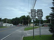
NY 126 begins at an intersection with NY 12New York State Route 12
New York State Route 12 is a state highway extending for through central and northern New York in the United States. The southern terminus of the route is at U.S. Route 11 in the town of Chenango in the Southern Tier. The northern terminus is at NY 37 near the village of...
located on the eastern city line of Watertown
Watertown (city), New York
Watertown is a city in the state of New York and the county seat of Jefferson County. It is situated approximately south of the Thousand Islands. As of the 2010 census, it had a population of 27,023, an increase of 1.2% since 2000. The U.S...
. The route heads east, passing through a predominantly residential area of the town of Watertown
Watertown (town), New York
Watertown is a town in Jefferson County, New York, United States. The population is 4,470.The Town of Watertown is located in the southeast part of the county...
. Roughly 1 miles (1.6 km) east of NY 12, the homes give way to open fields as the route enters the town of Rutland
Rutland, New York
Rutland is a town in Jefferson County, New York, United States. The population was 3,060 at the 2010 census.The Town of Rutland is in the eastern part of the town and is east of Watertown. Rutland is south of Fort Drum.- History :...
. Within Rutland, NY 126 serves only the small, rural hamlets of Rutland Center and Harpers Ferry before passing into the town of Champion
Champion, New York
Champion is a town in Jefferson County, New York, USA. The population was 4,494 at the 2010 census. The town is named after General Henry Champion, early owner.The Town of Champion is in the southern part of the county and is east of Watertown....
. 3 miles (5 km) into Champion, NY 126 enters the hamlet of the same name, situated at the junction of NY 126 and County Route 47. NY 126 passes east–west through the center of the small, mostly residential community before turning to the northeast as it leaves the hamlet.
West Carthage, New York
West Carthage is a village in Jefferson County, New York, United States. The population was 2,102 at the 2000 census.The Village of West Carthage is in the Town of Champion. The village is the east town line, and is east of Watertown...
, where it becomes known as Champion Street and meets NY 26
New York State Route 26
New York State Route 26 is a north–south state highway that runs for through Central New York in the United States. Its southern terminus is located at the Pennsylvania state line south of the town of Vestal in Broome County, where it becomes Pennsylvania Route 267...
west of the village center at Martin and North Broad Streets. NY 126 turns south onto North Broad Street, overlapping NY 26 south for four blocks through the mostly commercial western fringe of the village to Bridge Street. The two routes split here, with NY 26 continuing south out of the village on South Broad Street and NY 126 proceeding northeast through residential portions of the village on Bridge Street. At the northeast edge of West Carthage, NY 126 crosses the Black River
Black River (New York)
The Black River is a blackwater river that empties into the eastern end of Lake Ontario on the shore of Jefferson County, New York in the United States of America...
and enters the adjacent village of Carthage
Carthage, New York
Carthage is a village located in the Town of Wilna in Jefferson County, New York. The population was 3,721 at the 2000 census. The village is named after the historic Carthage in North Africa....
on the opposite bank, where NY 126 changes names to State Street.
The first three blocks of NY 126 within Carthage are located in a commercial neighborhood; however, the businesses give way to homes at School Street, which carries NY 3
New York State Route 3
New York State Route 3 is a major east–west state highway in New York, United States, that connects central New York to the North Country region near the Canadian border via Adirondack Park. The route extends for between its western terminus at an intersection with NY 104A in the Cayuga...
into the village from the northwest. NY 3 turns onto State Street here, overlapping NY 126 for one block to James Street. Here, NY 3 continues northeast on State Street while NY 126 turns southeast onto James Street. Although NY 126 exits the village and enters the town of Wilna
Wilna, New York
Wilna is a town in Jefferson County, New York, United States. The population was 6,427 at the 2010 census.The Town of Wilna is in the eastern corner of the county and is east of Watertown.- History :...
near Cemetery Street, homes continue to line the highway up to the point where NY 126 begins to follow the eastern bank of the Black River. The route exits Jefferson County
Jefferson County, New York
Jefferson County is a county located in the U.S. state of New York. As of the 2010 census, the population was 116,229. It is named after Thomas Jefferson, third President of the United States of America, and president at the time the county was created in 1805...
and enters Lewis County
Lewis County, New York
As of the census of 2000, there were 26,944 people, 10,040 households, and 7,309 families residing in the county. The population density was 21 people per square mile . There were 15,134 housing units at an average density of 12 per square mile...
roughly 0.25 mile (0.402335 km) later.
Lewis County
Now in the town of CroghanCroghan (town), New York
Croghan is a town in Lewis County, New York, USA. The population was 3,161 at the 2000 census. The town is named after George Croghan, a military officer....
, NY 126 becomes a rural connector highway once again as it runs in close proximity to the Black River. The two separate about 2 miles (3.2 km) south of the county line as NY 126 leaves the riverbank and follows a more northeasterly routing than the river through the town. NY 126 parallels the waterway to the hamlet of Naumburg, located near the point where the Beaver River
Beaver River (New York)
The Beaver River is a small mountain stream which flows from the Adirondack Mountains to the Black River at Naumberg, north of Lowville in northwestern New York. The Beaver flows through parts of Hamilton, Herkimer, and Lewis counties...
merges with the Black River. NY 126 intersects NY 410
New York State Route 410
New York State Route 410 is a state highway in Lewis County, New York, United States, that serves as a connector between NY 26, NY 126, and the village of Castorland.-Route description:...
in the center of the hamlet.
East of Naumburg, NY 126 follows the north bank of the Beaver River as it proceeds through rural Croghan. About 3 miles (5 km) from Naumburg, NY 126 crosses the river and enters the hamlet of Beaver Falls, a large community situated on the river. NY 126 bypasses most of the hamlet, however, as it runs through the lightly populated southern part of Beaver Falls instead of the more densely populated half on the north riverbank. Past Beaver Falls, NY 126 leaves the Beaver River and heads through fields and small forested areas to the village of Croghan
Croghan (village), New York
Croghan is a village in Lewis County, New York, USA. Its population was 665 at the 2000 census.The village is situated mainly in the south part of the town of Croghan, with a small part in New Bremen...
, where the highway is named Shady Avenue. The route continues as a residential street for two blocks to a junction with NY 812
New York State Route 812
New York State Route 812 is a state highway in the North Country of New York in the United States. The southern terminus of the route is at an intersection with NY 12 and NY 26 in the Lewis County village of Lowville...
just south of the village center, where NY 126 ends.
History
The origins of NY 126 date back to the 1930 renumbering of state highways in New York, when an alternate routing of NY 26New York State Route 26
New York State Route 26 is a north–south state highway that runs for through Central New York in the United States. Its southern terminus is located at the Pennsylvania state line south of the town of Vestal in Broome County, where it becomes Pennsylvania Route 267...
between Lowville
Lowville (village), New York
Lowville is a village in Lewis County, New York, United States. The Village is nestled in the Black River Valley, between the foothills of the Adirondack Mountains and the Tug Hill Plateau, and is located in the eastern part of the Town of Lowville....
and Carthage
Carthage, New York
Carthage is a village located in the Town of Wilna in Jefferson County, New York. The population was 3,721 at the 2000 census. The village is named after the historic Carthage in North Africa....
was designated as NY 26A. While NY 26 went directly between the two villages, NY 26A went northeast from Lowville to Croghan
Croghan (village), New York
Croghan is a village in Lewis County, New York, USA. Its population was 665 at the 2000 census.The village is situated mainly in the south part of the town of Croghan, with a small part in New Bremen...
before turning northwest and paralleling NY 26 to Carthage, where it ended at State Street (NY 3
New York State Route 3
New York State Route 3 is a major east–west state highway in New York, United States, that connects central New York to the North Country region near the Canadian border via Adirondack Park. The route extends for between its western terminus at an intersection with NY 104A in the Cayuga...
). At the time, NY 26A also ended at NY 26, which initially passed through Carthage and Antwerp
Antwerp (village), New York
Antwerp is a village in Jefferson County, New York, United States. The population was 716 at the 2000 census.The Village of Antwerp is in center of the Town of Antwerp and is northwest of Watertown.- History :...
on its way from West Carthage
West Carthage, New York
West Carthage is a village in Jefferson County, New York, United States. The population was 2,102 at the 2000 census.The Village of West Carthage is in the Town of Champion. The village is the east town line, and is east of Watertown...
to Theresa
Theresa (village), New York
Theresa is a village located in the Town of Theresa in Jefferson County, New York, USA. The population was 812 at the 2000 census.The Village of Theresa is northeast of Watertown.- History :...
. In West Carthage and Carthage, NY 26 followed Bridge and State Streets, resulting in an overlap with NY 3 through eastern Carthage.
The portion of NY 26 between Carthage and Antwerp was rerouted in 1960 to follow a new alignment via Calcium
Calcium, New York
Calcium is a hamlet in Jefferson County, New York, United States. The population was 3,516 as of July 2007.Calcium is in the Town of Le Ray and was formerly called Sanford's Corner....
, part of which used a new state highway northeast of Watertown
Watertown (city), New York
Watertown is a city in the state of New York and the county seat of Jefferson County. It is situated approximately south of the Thousand Islands. As of the 2010 census, it had a population of 27,023, an increase of 1.2% since 2000. The U.S...
. NY 26A may have been extended southwestward along State Street for one block to meet NY 26 as a result. NY 26 was truncated southward in the mid-1970s to the junction of State and School Streets, which had been the southern terminus of its overlap with NY 3 since 1960. In the late 1970s, NY 26A was supplanted by two new routes: NY 126, which was assigned to the Carthage–Croghan segment of NY 26A, and NY 812
New York State Route 812
New York State Route 812 is a state highway in the North Country of New York in the United States. The southern terminus of the route is at an intersection with NY 12 and NY 26 in the Lewis County village of Lowville...
, which extended from Lowville to Ogdensburg
Ogdensburg, New York
Ogdensburg is a city in St. Lawrence County, New York, United States. The population was 11,128 at the 2010 census. In the late 18th century, European-American settlers named the community after American land owner and developer Samuel Ogden....
via Croghan.
On August 1, 1979, the state of New York
New York
New York is a state in the Northeastern region of the United States. It is the nation's third most populous state. New York is bordered by New Jersey and Pennsylvania to the south, and by Connecticut, Massachusetts and Vermont to the east...
assumed ownership and maintenance of two county-maintained highways leading from West Carthage as part of a highway maintenance swap between the state and Jefferson County
Jefferson County, New York
Jefferson County is a county located in the U.S. state of New York. As of the 2010 census, the population was 116,229. It is named after Thomas Jefferson, third President of the United States of America, and president at the time the county was created in 1805...
. One connected West Carthage to Evans Mills
Evans Mills, New York
Evans Mills is a village in Jefferson County, New York, United States. The population was 605 at the 2000 census.The Village of Evans Mills in within the Town of Le Ray and is northeast of Watertown.- History :...
and became part of a re-extended NY 26; the other led from West Carthage to NY 12
New York State Route 12
New York State Route 12 is a state highway extending for through central and northern New York in the United States. The southern terminus of the route is at U.S. Route 11 in the town of Chenango in the Southern Tier. The northern terminus is at NY 37 near the village of...
in Watertown. The Watertown – West Carthage highway became part of an extended NY 126, which reached the new state highway by way of an overlap with NY 26 along North Broad Street in West Carthage and the former routing of NY 26 along Bridge and State Streets in West Carthage and Carthage.