
New York State Route 49
Encyclopedia
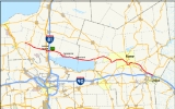
New York State Route 49 (NY 49) is an east–west state highway in New York
in the United States
. It runs from NY 3
in Volney
(east of Fulton
) to Interstate 790 (I-790), NY 5
, NY 8
and NY 12
in Utica
. A portion of it between Rome
and Utica is known as the Utica–Rome Expressway.
When it was originally assigned in the 1920s, NY 49 began at Central Square
and ended at Rome. It was extended to roughly its current length in 1930 and was later rerouted onto the Utica–Rome Expressway as it opened to traffic. The final piece of the expressway was completed in 2003.
in Volney
. The route heads eastward, intersecting with NY 264
just outside of Pennellville. The route crosses some local and county roads before entering Central Square
, where it intersects with U.S. Route 11
(US 11) in the village center. It is not long after that Route 49 meets I-81
at exit 32. Route 49 leaves Central Square and heads southeast toward both Constantia
and the Oneida Lake
shoreline.
 East of the hamlet of Constantia, the highway begins to parallel the north shore of Oneida Lake
. As the lakeside roadway, NY 49 provides access to both Bernhards Bay and Cleveland, two communities situated on the northern edge of the lake, before crossing into Oneida County
and intersecting with NY 13
at the northeast corner of Oneida Lake in the town of Vienna
. Here, NY 13 joins NY 49, overlapping the route to the hamlet of Vienna. While NY 13 heads north toward Camden
, NY 49 continues eastward, loosely paralleling Fish Creek
and Erie Canal
as it heads through rural Oneida County.
Midway between the hamlet of Vienna and downtown Rome
, NY 49 crosses over Fish Creek and enters the westernmost portion of Rome. Unlike eastern Rome, home to the downtown district, western Rome is largely rural and undeveloped, as evidenced by the Rome Sand Plains
located along the northern edge of NY 49. After 2.5 miles (4 km) of rural surroundings, the route passes out of Rome and into Verona
upon traversing Wood Creek. The road continues south to the community of New London, where it intersects and joins NY 46
on the north bank of the Erie Canal.
Routes 49 and 46 head to the northeast, separating from the canal as it reenters Rome. Northwest of downtown, the routes are joined by NY 69
as they enter downtown on Erie Boulevard. At Black River Boulevard, Route 46 turns off; however, NY 26
turns onto Erie Boulevard, taking the place of NY 46 in the three-route concurrency. Together, Routes 26, 49 and 69 head south to a directional-T interchange with NY 365
, the first exit on the Utica-Rome Expressway. While NY 26 leaves to the west, NY 49 and NY 69 head east, embarking on an overlap with NY 365.
as NY 69 exits to follow Rome-Oriskany Road to Utica
. NY 49 and NY 365 continue on, turning northward to pass over the Mohawk River
, the CSX Transportation
Rome yard
, and the Erie Canal in quick succession near the eastern edge of downtown Rome. Shortly over passing over the canal, NY 365 exits the expressway as well, leaving only NY 49 on the roadway. As the expressway curves back to the east, it crosses a railroad spur
leading to the former Griffiss Air Force Base
at-grade, a rare occurrence on limited-access highways. Route 49 then meets NY 825
, the vehicular southern entrance to the ex-base, by way of an interchange before leaving the Rome limits.
As the expressway continues southeast through the towns of Floyd
and Marcy
toward Utica, it parallels both the Erie Canal, located due south of the roadway, and the Mohawk River, situated between the canal and the CSX Transportation mainline. In Marcy, NY 49 has an exit for River Street, a connector between the expressway and Oriskany
, and another for NY 291
near the hamlet of Marcy. Farther east, the freeway meets Cavanaugh Road by way of a parclo interchange
.
Just east of Cavanaugh Road, the median of the expressway widens as it heads toward the New York State Thruway
(I-90). At the Thruway, the eastbound lanes of NY 49 cross over I-90 while the westbound lanes do not, creating an unusual situation in that its westbound lanes run parallel to the Thruway to the latter's north, with the eastbound lanes to the south. North of downtown Utica, NY 49 encounters Edic Road. The expressway officially enters Utica shortly afterward, where Route 49 terminates at a complex interchange between itself, NY 5
, NY 8
, NY 12
, and I-790
. Although NY 49 ends, the expressway continues for an additional 1 miles (1.6 km) to Leland Avenue as NY 5.
and ended at NY 11 (modern NY 69
) in Rome
. At the time, the portion of River Road from Rome to Marcy
(at what is now NY 291
) was part of NY 11, which had been in place since 1924. In 1927, NY 11 was renumbered to NY 76 to eliminate duplication with the new US 11. In the 1930 renumbering of state highways in New York, NY 76 was broken up and incorporated into several other routes. From Rome to Marcy, the former routing of NY 76 became an extension of NY 49. The route then continued eastward along River Road to a new terminus at Genesee Street (then-NY 5
, NY 8
, and NY 12
) in Utica. On its western end, NY 49 was extended over a previously unnumbered roadway to Volney
, where it ended at NY 3C (now NY 3
). Based on reference marker
s at NY 49's western terminus, the route once extended westward into Fulton
by way of an overlap with NY 3. This overlap was eliminated by 1970.
By 1978, NY 49 had been routed off River Road and onto the new Utica-Rome Expressway from the Dominick Street interchange to NY 291. An extension of the freeway northwest to NY 365
south of downtown Rome was opened in 1980, at which time it, as well as another arterial leading from Rome, became part of NY 49. By 1995, an interchange was constructed between Edic Road and the North–South Arterial (NY 5/8/12 and I-790
). In 2003, the final section of the expressway between NY 291 and Edic Road (where it connected to the pre-existing exit ramps) was completed. NY 49 was then rerouted to follow the expressway into Utica. The former routing of NY 49 along River Road from NY 365 to NY 291 was transferred to Oneida County
and is now designated as County Route 88 while the segment of River Road from the Dominick Street interchange to New Floyd Road remains part of NY 365. Ownership and maintenance of the remainder of River Road was transferred to the cities and towns it passed through.
|colspan=3 align="center"|West end of freeway section
|-
|-
|50.76
|
|NY 69 joins westbound and leaves eastbound; northern terminus of NY 233
|-
|51.88
|
|Westbound exit is combined with NY 825 exit; NY 365 joins westbound and leaves eastbound
|-
|rowspan=3|Floyd
|
|
|
|-
|58.06
|Oriskany
|
|-
|60.18
|
|
|-
|rowspan=2|Marcy
|61.41
|Cavanaugh Road – Whitesboro
|
|-
|63.13
|Edic Road – SUNYIT
, Marcy Business District
|No westbound entrance
|-
|rowspan=3|Utica
|rowspan=3|64.13
|
|Eastbound exit and westbound entrance
|-
|
|Eastbound exit and westbound entrance
|-
|
|Eastbound exit and westbound entrance
New York
New York is a state in the Northeastern region of the United States. It is the nation's third most populous state. New York is bordered by New Jersey and Pennsylvania to the south, and by Connecticut, Massachusetts and Vermont to the east...
in the United States
United States
The United States of America is a federal constitutional republic comprising fifty states and a federal district...
. It runs from NY 3
New York State Route 3
New York State Route 3 is a major east–west state highway in New York, United States, that connects central New York to the North Country region near the Canadian border via Adirondack Park. The route extends for between its western terminus at an intersection with NY 104A in the Cayuga...
in Volney
Volney, New York
Volney is a town in Oswego County, New York, United States. The population was 6,094 at the 2000 census. The town was named after a French author who toured the area in 1808.The Town of Volney is centrally located in the county.- History :...
(east of Fulton
Fulton, Oswego County, New York
Fulton is a small city in Oswego County, New York, United States. The population was 11,855 at the 2000 census. The city is named after Robert Fulton, inventor of the steamboat.The city of Fulton is located in the western part of the county....
) to Interstate 790 (I-790), NY 5
New York State Route 5
New York State Route 5 is a state highway that extends for across the state of New York in the United States. It begins at the Pennsylvania state line in the Chautauqua County town of Ripley and passes through Buffalo, Syracuse, Utica, Schenectady, and several other smaller cities and...
, NY 8
New York State Route 8
New York State Route 8 is a state highway in the central part of New York in the United States. It runs in a southwest-to-northeast direction from the Southern Tier to the northern part of Lake George. The southern terminus of the route is at an interchange with NY 17 in the town of...
and NY 12
New York State Route 12
New York State Route 12 is a state highway extending for through central and northern New York in the United States. The southern terminus of the route is at U.S. Route 11 in the town of Chenango in the Southern Tier. The northern terminus is at NY 37 near the village of...
in Utica
Utica, New York
Utica is a city in and the county seat of Oneida County, New York, United States. The population was 62,235 at the 2010 census, an increase of 2.6% from the 2000 census....
. A portion of it between Rome
Rome, New York
Rome is a city in Oneida County, New York, United States. It is located in north-central or "upstate" New York. The population was 44,797 at the 2010 census. It is in New York's 24th congressional district. In 1758, British forces began construction of Fort Stanwix at this strategic location, but...
and Utica is known as the Utica–Rome Expressway.
When it was originally assigned in the 1920s, NY 49 began at Central Square
Central Square, New York
Central Square is a village in Oswego County, New York, United States. The population was 1,646 at the 2000 census.The Village of Central Square is located in the south part of the Town of Hastings on Route 49 and US Route 11. The village is west of Interstate 81...
and ended at Rome. It was extended to roughly its current length in 1930 and was later rerouted onto the Utica–Rome Expressway as it opened to traffic. The final piece of the expressway was completed in 2003.
West of Rome
NY 49 begins at an intersection with NY 3New York State Route 3
New York State Route 3 is a major east–west state highway in New York, United States, that connects central New York to the North Country region near the Canadian border via Adirondack Park. The route extends for between its western terminus at an intersection with NY 104A in the Cayuga...
in Volney
Volney, New York
Volney is a town in Oswego County, New York, United States. The population was 6,094 at the 2000 census. The town was named after a French author who toured the area in 1808.The Town of Volney is centrally located in the county.- History :...
. The route heads eastward, intersecting with NY 264
New York State Route 264
New York State Route 264 is a north–south state highway in Oswego County, New York, United States. It runs from an intersection with County Route 57 in the village of Phoenix north to a junction with NY 3 in the town of Palermo...
just outside of Pennellville. The route crosses some local and county roads before entering Central Square
Central Square, New York
Central Square is a village in Oswego County, New York, United States. The population was 1,646 at the 2000 census.The Village of Central Square is located in the south part of the Town of Hastings on Route 49 and US Route 11. The village is west of Interstate 81...
, where it intersects with U.S. Route 11
U.S. Route 11 in New York
U.S. Route 11 is a part of the U.S. Highway System that runs from New Orleans, Louisiana, to the Canadian border at Rouses Point, New York...
(US 11) in the village center. It is not long after that Route 49 meets I-81
Interstate 81 in New York
Interstate 81 is a part of the Interstate Highway System that runs from Dandridge, Tennessee, to the Canada – United States border at Wellesley Island in New York. In the U.S. state of New York, I-81 extends from the Pennsylvania state line southeast of Binghamton to the Canadian border...
at exit 32. Route 49 leaves Central Square and heads southeast toward both Constantia
Constantia (CDP), New York
Constantia is a census-designated place in the town of Constantia in Oswego County, New York, United States. Located on Oneida Lake, the community lies along State Route 49 and Scriba Creek...
and the Oneida Lake
Oneida Lake
Oneida Lake is the largest lake entirely within New York State . The lake is located northeast of Syracuse and near the Great Lakes. It serves as one of the links in the Erie Canal. It empties into the Oneida River which flows into the Oswego River which in turn flows into Lake Ontario...
shoreline.
Oneida Lake
Oneida Lake is the largest lake entirely within New York State . The lake is located northeast of Syracuse and near the Great Lakes. It serves as one of the links in the Erie Canal. It empties into the Oneida River which flows into the Oswego River which in turn flows into Lake Ontario...
. As the lakeside roadway, NY 49 provides access to both Bernhards Bay and Cleveland, two communities situated on the northern edge of the lake, before crossing into Oneida County
Oneida County, New York
Oneida County is a county located in the U.S. state of New York. As of the 2010 census, the population was 234,878. The county seat is Utica. The name is in honor of the Oneida, an Iroquoian tribe that formerly occupied the region....
and intersecting with NY 13
New York State Route 13
New York State Route 13 is a state highway that runs mainly north–south for between NY 14 in Horseheads and NY 3 west of Pulaski in Central New York in the United States. In between, NY 13 intersects with Interstate 81 in Cortland and Pulaski and meets the New York...
at the northeast corner of Oneida Lake in the town of Vienna
Vienna, New York
Vienna is a town in Oneida County, New York, United States. The population was 5,819 at the 2000 census. The town is named after the capital of Austria.The Town of Vienna is in the western part of the county.- History :...
. Here, NY 13 joins NY 49, overlapping the route to the hamlet of Vienna. While NY 13 heads north toward Camden
Camden (village), New York
Camden is a village in Oneida County, New York, USA. The population was 2,330 at the 2000 census.The Village of Camden is located inside the Town of Camden at the crossing of Routes NY-13 and NY-69.-History:The W.H...
, NY 49 continues eastward, loosely paralleling Fish Creek
Fish Creek
-Streams:* Fish Creek ** Battle of Fish Creek, took place at the above creek* Fish Creek , in Fish Creek Provincial Park-Communities:* Fish Creek No. 402, Saskatchewan, rural municipality* Fish Creek, Victoria, Australian township...
and Erie Canal
Erie Canal
The Erie Canal is a waterway in New York that runs about from Albany, New York, on the Hudson River to Buffalo, New York, at Lake Erie, completing a navigable water route from the Atlantic Ocean to the Great Lakes. The canal contains 36 locks and encompasses a total elevation differential of...
as it heads through rural Oneida County.
Midway between the hamlet of Vienna and downtown Rome
Rome, New York
Rome is a city in Oneida County, New York, United States. It is located in north-central or "upstate" New York. The population was 44,797 at the 2010 census. It is in New York's 24th congressional district. In 1758, British forces began construction of Fort Stanwix at this strategic location, but...
, NY 49 crosses over Fish Creek and enters the westernmost portion of Rome. Unlike eastern Rome, home to the downtown district, western Rome is largely rural and undeveloped, as evidenced by the Rome Sand Plains
Rome Sand Plains
Rome Sand Plains is a pine barrens consisting of a mosaic of sand dunes extending about above low peat bogs that lie between the dunes. The barrens are covered with mixed northern hardwood forests, meadows, and wetlands. The sand plains are about west of the city center of Rome, New York, which...
located along the northern edge of NY 49. After 2.5 miles (4 km) of rural surroundings, the route passes out of Rome and into Verona
Verona, New York
Verona is a town in Oneida County, New York, United States. The population was 6,425 at the 2000 census. The source of the town name is unknown, though it's possibly named after Verona, Italy....
upon traversing Wood Creek. The road continues south to the community of New London, where it intersects and joins NY 46
New York State Route 46
New York State Route 46 is a state highway in Central New York, United States. It extends from NY 12B in the Madison County town of Eaton to NY 12D in the Oneida County village of Boonville. NY 46 passes through the cities of Oneida and Rome.-Madison County:NY 46 begins at...
on the north bank of the Erie Canal.
Routes 49 and 46 head to the northeast, separating from the canal as it reenters Rome. Northwest of downtown, the routes are joined by NY 69
New York State Route 69
New York State Route 69 is a state highway extending for across the central portion of the U.S. state of New York. The western terminus of the route is at NY 104 in the Oswego County village of Mexico. The eastern terminus is at NY 5A in the Oneida County village of Yorkville, just...
as they enter downtown on Erie Boulevard. At Black River Boulevard, Route 46 turns off; however, NY 26
New York State Route 26
New York State Route 26 is a north–south state highway that runs for through Central New York in the United States. Its southern terminus is located at the Pennsylvania state line south of the town of Vestal in Broome County, where it becomes Pennsylvania Route 267...
turns onto Erie Boulevard, taking the place of NY 46 in the three-route concurrency. Together, Routes 26, 49 and 69 head south to a directional-T interchange with NY 365
New York State Route 365
New York State Route 365 is an east–west state highway in the central portion of New York in the United States. It extends for from an intersection with NY 5 east of the Oneida County city of Oneida to a junction with NY 8 in the Herkimer County town of Ohio...
, the first exit on the Utica-Rome Expressway. While NY 26 leaves to the west, NY 49 and NY 69 head east, embarking on an overlap with NY 365.
Utica-Rome Expressway
At the first interchange east of the directional-T, the expressway meets NY 233New York State Route 233
New York State Route 233 is a state highway in Oneida County, New York, United States. The southern terminus of the route is at an intersection with NY 12B southwest of the Clinton. Its northern terminus is at an interchange with the Utica–Rome Expressway within the Rome city limits but...
as NY 69 exits to follow Rome-Oriskany Road to Utica
Utica, New York
Utica is a city in and the county seat of Oneida County, New York, United States. The population was 62,235 at the 2010 census, an increase of 2.6% from the 2000 census....
. NY 49 and NY 365 continue on, turning northward to pass over the Mohawk River
Mohawk River
The Mohawk River is a river in the U.S. state of New York. It is the largest tributary of the Hudson River. The Mohawk flows into the Hudson in the Capital District, a few miles north of the city of Albany. The river is named for the Mohawk Nation of the Iroquois Confederacy...
, the CSX Transportation
CSX Transportation
CSX Transportation operates a Class I railroad in the United States known as the CSX Railroad. It is the main subsidiary of the CSX Corporation. The company is headquartered in Jacksonville, Florida, and owns approximately 21,000 route miles...
Rome yard
Classification yard
A classification yard or marshalling yard is a railroad yard found at some freight train stations, used to separate railroad cars on to one of several tracks. First the cars are taken to a track, sometimes called a lead or a drill...
, and the Erie Canal in quick succession near the eastern edge of downtown Rome. Shortly over passing over the canal, NY 365 exits the expressway as well, leaving only NY 49 on the roadway. As the expressway curves back to the east, it crosses a railroad spur
Branch line
A branch line is a secondary railway line which branches off a more important through route, usually a main line. A very short branch line may be called a spur line...
leading to the former Griffiss Air Force Base
Griffiss Air Force Base
Griffiss Air Force Base, is a former United States Air Force base, located in Rome, New York, about NW of Utica. Missions at Griffiss AFB included fighter interceptors, electronic research, installation, and support activities, aerial refueling, and bombers...
at-grade, a rare occurrence on limited-access highways. Route 49 then meets NY 825
New York State Route 825
New York State Route 825 is a state highway in Oneida County, New York, in the United States. It connects the former Griffiss Air Force Base to the Utica–Rome Expressway and downtown Rome. The southern terminus is at an interchange with NY 49 east of downtown Rome...
, the vehicular southern entrance to the ex-base, by way of an interchange before leaving the Rome limits.
As the expressway continues southeast through the towns of Floyd
Floyd, New York
Floyd is a town in Oneida County, New York, United States. The population was 3,869 at the 2000 census. The town is named after William Floyd, a signer of the Declaration of Independence....
and Marcy
Marcy, New York
Marcy is a town in Oneida County, New York, United States. The population was 9,469 at the 2000 census. The town was named after Governor William L. Marcy....
toward Utica, it parallels both the Erie Canal, located due south of the roadway, and the Mohawk River, situated between the canal and the CSX Transportation mainline. In Marcy, NY 49 has an exit for River Street, a connector between the expressway and Oriskany
Oriskany, New York
Oriskany is a village in Oneida County, New York, United States. The population was 2,744 at the 2000 census. The name is derived from the Iroquois word for "nettles."The Village of Oriskany is in the Town of Whitestown, southeast of the City of Rome...
, and another for NY 291
New York State Route 291
New York State Route 291 is a state highway in Oneida County, New York, in the United States. The route extends from an intersection with NY 69 in the town of Whitestown to a junction with NY 365 in the extreme northern tip of the town of Marcy, near the hamlet of Stittville. It is...
near the hamlet of Marcy. Farther east, the freeway meets Cavanaugh Road by way of a parclo interchange
Parclo interchange
A partial cloverleaf interchange or parclo is a modification of a cloverleaf interchange. The parclo interchange was developed by the Ontario Ministry of Transportation as a replacement for the cloverleaf on 400-Series Highways, removing the dangerous weaving patterns and allowing for more...
.
Just east of Cavanaugh Road, the median of the expressway widens as it heads toward the New York State Thruway
New York State Thruway
The New York State Thruway is a system of limited-access highways located within the state of New York in the United States. The system, known officially as the Governor Thomas E. Dewey Thruway for former New York Governor Thomas E. Dewey, is operated by the New York State Thruway Authority and...
(I-90). At the Thruway, the eastbound lanes of NY 49 cross over I-90 while the westbound lanes do not, creating an unusual situation in that its westbound lanes run parallel to the Thruway to the latter's north, with the eastbound lanes to the south. North of downtown Utica, NY 49 encounters Edic Road. The expressway officially enters Utica shortly afterward, where Route 49 terminates at a complex interchange between itself, NY 5
New York State Route 5
New York State Route 5 is a state highway that extends for across the state of New York in the United States. It begins at the Pennsylvania state line in the Chautauqua County town of Ripley and passes through Buffalo, Syracuse, Utica, Schenectady, and several other smaller cities and...
, NY 8
New York State Route 8
New York State Route 8 is a state highway in the central part of New York in the United States. It runs in a southwest-to-northeast direction from the Southern Tier to the northern part of Lake George. The southern terminus of the route is at an interchange with NY 17 in the town of...
, NY 12
New York State Route 12
New York State Route 12 is a state highway extending for through central and northern New York in the United States. The southern terminus of the route is at U.S. Route 11 in the town of Chenango in the Southern Tier. The northern terminus is at NY 37 near the village of...
, and I-790
Interstate 790
Interstate 790 is an auxiliary Interstate Highway in the city of Utica, New York, in the United States. It runs for from an interchange with NY 5A and NY 5S in downtown Utica to exit 31 of the New York State Thruway east of the city...
. Although NY 49 ends, the expressway continues for an additional 1 miles (1.6 km) to Leland Avenue as NY 5.
History
When NY 49 was assigned in the mid-1920s, it began at NY 2 (now US 11) in Central SquareCentral Square, New York
Central Square is a village in Oswego County, New York, United States. The population was 1,646 at the 2000 census.The Village of Central Square is located in the south part of the Town of Hastings on Route 49 and US Route 11. The village is west of Interstate 81...
and ended at NY 11 (modern NY 69
New York State Route 69
New York State Route 69 is a state highway extending for across the central portion of the U.S. state of New York. The western terminus of the route is at NY 104 in the Oswego County village of Mexico. The eastern terminus is at NY 5A in the Oneida County village of Yorkville, just...
) in Rome
Rome, New York
Rome is a city in Oneida County, New York, United States. It is located in north-central or "upstate" New York. The population was 44,797 at the 2010 census. It is in New York's 24th congressional district. In 1758, British forces began construction of Fort Stanwix at this strategic location, but...
. At the time, the portion of River Road from Rome to Marcy
Marcy, New York
Marcy is a town in Oneida County, New York, United States. The population was 9,469 at the 2000 census. The town was named after Governor William L. Marcy....
(at what is now NY 291
New York State Route 291
New York State Route 291 is a state highway in Oneida County, New York, in the United States. The route extends from an intersection with NY 69 in the town of Whitestown to a junction with NY 365 in the extreme northern tip of the town of Marcy, near the hamlet of Stittville. It is...
) was part of NY 11, which had been in place since 1924. In 1927, NY 11 was renumbered to NY 76 to eliminate duplication with the new US 11. In the 1930 renumbering of state highways in New York, NY 76 was broken up and incorporated into several other routes. From Rome to Marcy, the former routing of NY 76 became an extension of NY 49. The route then continued eastward along River Road to a new terminus at Genesee Street (then-NY 5
New York State Route 5
New York State Route 5 is a state highway that extends for across the state of New York in the United States. It begins at the Pennsylvania state line in the Chautauqua County town of Ripley and passes through Buffalo, Syracuse, Utica, Schenectady, and several other smaller cities and...
, NY 8
New York State Route 8
New York State Route 8 is a state highway in the central part of New York in the United States. It runs in a southwest-to-northeast direction from the Southern Tier to the northern part of Lake George. The southern terminus of the route is at an interchange with NY 17 in the town of...
, and NY 12
New York State Route 12
New York State Route 12 is a state highway extending for through central and northern New York in the United States. The southern terminus of the route is at U.S. Route 11 in the town of Chenango in the Southern Tier. The northern terminus is at NY 37 near the village of...
) in Utica. On its western end, NY 49 was extended over a previously unnumbered roadway to Volney
Volney, New York
Volney is a town in Oswego County, New York, United States. The population was 6,094 at the 2000 census. The town was named after a French author who toured the area in 1808.The Town of Volney is centrally located in the county.- History :...
, where it ended at NY 3C (now NY 3
New York State Route 3
New York State Route 3 is a major east–west state highway in New York, United States, that connects central New York to the North Country region near the Canadian border via Adirondack Park. The route extends for between its western terminus at an intersection with NY 104A in the Cayuga...
). Based on reference marker
Reference marker (New York)
In New York, a reference marker is a small green sign mounted approximately every one-tenth mile on highways maintained by the New York State Department of Transportation. This was initiated in response to the Highway Safety Act of 1966 enacted by Congress, in an effort to monitor traffic and...
s at NY 49's western terminus, the route once extended westward into Fulton
Fulton, Oswego County, New York
Fulton is a small city in Oswego County, New York, United States. The population was 11,855 at the 2000 census. The city is named after Robert Fulton, inventor of the steamboat.The city of Fulton is located in the western part of the county....
by way of an overlap with NY 3. This overlap was eliminated by 1970.
By 1978, NY 49 had been routed off River Road and onto the new Utica-Rome Expressway from the Dominick Street interchange to NY 291. An extension of the freeway northwest to NY 365
New York State Route 365
New York State Route 365 is an east–west state highway in the central portion of New York in the United States. It extends for from an intersection with NY 5 east of the Oneida County city of Oneida to a junction with NY 8 in the Herkimer County town of Ohio...
south of downtown Rome was opened in 1980, at which time it, as well as another arterial leading from Rome, became part of NY 49. By 1995, an interchange was constructed between Edic Road and the North–South Arterial (NY 5/8/12 and I-790
Interstate 790
Interstate 790 is an auxiliary Interstate Highway in the city of Utica, New York, in the United States. It runs for from an interchange with NY 5A and NY 5S in downtown Utica to exit 31 of the New York State Thruway east of the city...
). In 2003, the final section of the expressway between NY 291 and Edic Road (where it connected to the pre-existing exit ramps) was completed. NY 49 was then rerouted to follow the expressway into Utica. The former routing of NY 49 along River Road from NY 365 to NY 291 was transferred to Oneida County
Oneida County, New York
Oneida County is a county located in the U.S. state of New York. As of the 2010 census, the population was 234,878. The county seat is Utica. The name is in honor of the Oneida, an Iroquoian tribe that formerly occupied the region....
and is now designated as County Route 88 while the segment of River Road from the Dominick Street interchange to New Floyd Road remains part of NY 365. Ownership and maintenance of the remainder of River Road was transferred to the cities and towns it passed through.
Major intersections
|-|colspan=3 align="center"|West end of freeway section
|-
|-
|50.76
|
|NY 69 joins westbound and leaves eastbound; northern terminus of NY 233
|-
|51.88
|
|Westbound exit is combined with NY 825 exit; NY 365 joins westbound and leaves eastbound
|-
|rowspan=3|Floyd
Floyd, New York
Floyd is a town in Oneida County, New York, United States. The population was 3,869 at the 2000 census. The town is named after William Floyd, a signer of the Declaration of Independence....
|
|
|
|-
|58.06
|Oriskany
|
|-
|60.18
|
|
|-
|rowspan=2|Marcy
Marcy, New York
Marcy is a town in Oneida County, New York, United States. The population was 9,469 at the 2000 census. The town was named after Governor William L. Marcy....
|61.41
|Cavanaugh Road – Whitesboro
|
|-
|63.13
|Edic Road – SUNYIT
State University of New York Institute of Technology
The State University of New York Institute of Technology at Utica/Rome is a campus of the State University of New York located just north of Utica in the town of Marcy. Established by the SUNY Board of Trustees on June 14, 1966, SUNYIT is the State of New York's public institute of technology....
, Marcy Business District
|No westbound entrance
|-
|rowspan=3|Utica
Utica, New York
Utica is a city in and the county seat of Oneida County, New York, United States. The population was 62,235 at the 2010 census, an increase of 2.6% from the 2000 census....
|rowspan=3|64.13
|
|Eastbound exit and westbound entrance
|-
|
|Eastbound exit and westbound entrance
|-
|
|Eastbound exit and westbound entrance