

Pawtuxet River
Encyclopedia
River
A river is a natural watercourse, usually freshwater, flowing towards an ocean, a lake, a sea, or another river. In a few cases, a river simply flows into the ground or dries up completely before reaching another body of water. Small rivers may also be called by several other names, including...
in the U.S.
United States
The United States of America is a federal constitutional republic comprising fifty states and a federal district...
state of Rhode Island
Rhode Island
The state of Rhode Island and Providence Plantations, more commonly referred to as Rhode Island , is a state in the New England region of the United States. It is the smallest U.S. state by area...
. It flows 12.3 miles (19.8 km) and drains a watershed of 231.6 square miles (599.8 km²). There are four dams along the river's length.
Course
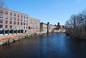
The Pawtuxet River Valley played an important role in the early development of the textile industry in New EnglandNew England
New England is a region in the northeastern corner of the United States consisting of the six states of Maine, New Hampshire, Vermont, Massachusetts, Rhode Island, and Connecticut...
during the 19th century.
The river is formed by the confluence of North
North Branch Pawtuxet River
The North Branch Pawtuxet River is a river in the U.S. state of Rhode Island. It flows approximately . There are 9 dams along the river's length.-Course:...
and South
South Branch Pawtuxet River
The South Branch Pawtuxet River is a river in the U.S. state of Rhode Island. It flows approximately . There are 11 dams along the river's length.-Course:...
branches of the river at River Point village in West Warwick
West Warwick, Rhode Island
West Warwick is a town in Kent County, Rhode Island, United States. The population was 29,191 at the 2010 census.West Warwick was incorporated in 1913, making it the youngest town in the state. Prior to 1913, the town, situated on the western bank of the Pawtuxet River, was the population and...
. From the park, the river continues roughly east, through West Warwick, Warwick
Warwick, Rhode Island
Warwick is a city in Kent County, Rhode Island, United States. It is the second largest city in the state, with a population of 82,672 at the 2010 census. Its mayor has been Scott Avedisian since 2000...
and Cranston
Cranston, Rhode Island
Cranston, once known as Pawtuxet, is a city in Providence County, Rhode Island, United States. With a population of 80,387 at the 2010 census, it is the third largest city in the state. The center of population of Rhode Island is located in Cranston...
, emptying into the Providence River
Providence River
thumb|The city of Providence as seen from the Providence River at its confluence with the Narragansett BayThe Providence River is a tidal river in the U.S. state of Rhode Island. It flows approximately 8 miles...
at Pawtuxet Village
Pawtuxet Village
Pawtuxet Village is a section of the towns of Warwick and Cranston, Rhode Island. It is located at the point where the Pawtuxet River flows into the Providence River and Narragansett Bay.- History :...
. The last three miles (5 km) of the river form the boundary between Cranston and Warwick.
Crossings
Below is a list of all crossings over the Pawtuxet River. The list starts at the headwaters and goes downstream.- West Warwick
- Pulaski Street (South Branch)
- Main Street at Veteran's Square (South Branch)
- Factory Street - the Arctic Dam (South Branch)
- Providence Street at Royal Mills (South Branch)
- Main Street in Clyde Square (North Branch)
- Providence Street at Water Street (at the West Warwick, Warwick Town/City line)
- Warwick
- East Avenue
- Bald Hill Road (RI 2Route 2 (Rhode Island)Route 2 is a state highway in the U.S. state of Rhode Island.-Route:Route 2 takes the following route through the State:*Charlestown: ; U.S...
) - Interstate 295Interstate 295 (Rhode Island-Massachusetts)Interstate 295 is an Interstate route in length within the U.S. states of Rhode Island and Massachusetts. It serves as a western bypass around Providence, Rhode Island. The southern terminus is a junction with I-95 in Warwick, Rhode Island...
- Greenwich Avenue (RI 5Route 5 (Rhode Island)-Route description:Route 5 takes the following route through the State:*Warwick: ; US 1 to Cranston city line**Greenwich Avenue and Lambert Lind Highway*Cranston: ; Warwick city line to Johnston town line**Oaklawn Avenue and Atwood Avenue...
) - Rhode Island State Route 37Route 37 (Rhode Island)Route 37, also known as the Lincoln Avenue Freeway, is a numbered state highway running in Providence County and Kent County, Rhode Island, United States. The route is a nominally east–west freeway for its entire length. Route 37 serves the cities of Cranston and Warwick and is also a major...
- Interstate 95Interstate 95 in Rhode IslandInterstate 95, the main north–south Interstate Highway on the east coast of the United States, runs generally southwest-northeast through the U.S. state of Rhode Island. It runs from the border with Connecticut near Westerly through Warwick and Providence and to the Massachusetts state line...
- Elmwood Avenue (U.S. 1)
- Warwick Avenue (U.S. 1A/RI 117Route 117 (Rhode Island)-Route:*Coventry: 14.0 miles ; Route 14 to West Warwick town line**Flat River Road, Main Street and Washington Street*West Warwick: 1.8 miles ; Coventry town line to Warwick city line**West Warwick Avenue, Main Street and Legris Avenue...
) - Post Road
Tributaries
Three Ponds Brook and the Pocasset RiverPocasset River (Rhode Island)
The Pocasset River is a river in the U.S. state of Rhode Island. It flows . There are five dams along the river's length.-Course:The Pocasset River rises between Brown Avenue and Belfield Drive in Johnston...
are the Pawtuxet River's only named tributaries, though it has many unnamed streams that also feed it.
Water quality
The Pawtuxet River is impacted by cadmium, mercury, pathogens, low dissolved oxygen and nutrients. It shows biodiversity impacts (Rhode Island 2006 List of Impaired Waters). The Rhode Island Department of Environmental Management http://www.dem.ri.gov/ has issued new discharge permits to the three major municipal wastewater treatment plants that discharge to the River (West Warwick, Rhode IslandWest Warwick, Rhode Island
West Warwick is a town in Kent County, Rhode Island, United States. The population was 29,191 at the 2010 census.West Warwick was incorporated in 1913, making it the youngest town in the state. Prior to 1913, the town, situated on the western bank of the Pawtuxet River, was the population and...
, Warwick, Rhode Island
Warwick, Rhode Island
Warwick is a city in Kent County, Rhode Island, United States. It is the second largest city in the state, with a population of 82,672 at the 2010 census. Its mayor has been Scott Avedisian since 2000...
and Cranston, Rhode Island
Cranston, Rhode Island
Cranston, once known as Pawtuxet, is a city in Providence County, Rhode Island, United States. With a population of 80,387 at the 2010 census, it is the third largest city in the state. The center of population of Rhode Island is located in Cranston...
). These plants are major contributors of nutrients to the river.
Habitat restoration
The Rhode Island Department of Environmental Management's Rhode Island Anadromous Fish Restoration Plan gives the Pawtuxet River a low overall ranking due to the river's poor water quality and the large number of dams. However, the Pawtuxet River Authority and Watershed Council http://pawtuxet.org/projects.html is working with sate and federal partners to evaluate fish passage alternatives for the first dam on the Pawtuxet, the Pawtuxet Falls Dam. Fish passage at this dam will open up 7.5 miles (12.1 km) of spawning habitat above the dam on the main stem of the river.Water use and availability
The Scituate ReservoirScituate Reservoir
The Scituate Reservoir is the largest inland body of water in the state of Rhode Island. It has an aggregate capacity of and a surface area of 5.3 square miles...
on the North Branch of the Pawtuxet River provides over 60 % of the water supply to the State of Rhode Island (USGS, Estimated Water Use and Availability in the Pawtuxet and Quinebaug River Basins, Rhode Island). This water is supplied to almost all the other basins in Rhode Island including the Blackstone River
Blackstone River
The Blackstone River is a river in the U.S. states of Massachusetts and Rhode Island. It flows approximately 48 mi and drains a watershed of approximately 540 sq. mi...
, Ten Mile River
Ten Mile River
The Ten Mile River is a river within the U.S. states of Massachusetts and Rhode Island. It flows approximately and drains a watershed of .The North Attleborough National Fish Hatchery is located in its upper reaches, and the river offers stocked trout fishing in the spring.The Ten Mile River was...
, Moshassuck River
Moshassuck River
The Moshassuck River is a river in the U.S. state of Rhode Island. It flows from the town of Lincoln to the city of Providence. There are six dams along the river's length.- History :...
, Woonasquatucket River
Woonasquatucket River
The Woonasquatucket River is a river in the U.S. state of Rhode Island. It flows approximately and drains a watershed of 130 km² ....
, Narragansett Bay
Narragansett Bay
Narragansett Bay is a bay and estuary on the north side of Rhode Island Sound. Covering 147 mi2 , the Bay forms New England's largest estuary, which functions as an expansive natural harbor, and includes a small archipelago...
and the Westport River
Westport River
The Westport River lies between Narragansett Bay and Buzzards Bay in Westport, Massachusetts.-Description:The Westport River has two branches. The smaller West Branch is approximately long, rising from a confluence of brooks near the village of Adamsville, Rhode Island...
. About 22 % of the major public supply withdrawn from the Pawtuxet basin is returned to the basin and about 51 % is exported to other basins. Some of the water exported out of the basin for drinking water returns to the Pawtuxet River as wastewater.
Flow
The US Geological Survey has five gauges in the Pawtuxet Watershed- PONAGANSET RIVER AT SOUTH FOSTER, RI
- NOOSENECK RIVER AT NOOSENECK, RI
- CARR RIVER NEAR NOOSENECK, RI
- SOUTH BRANCH PAWTUXET RIVER AT WASHINGTON, RI
- PAWTUXET RIVER AT CRANSTON, RI
The Pawtuxet River experiences periodic flooding. In October 2005 remnants of Tropical Storm Tammy
Tropical Storm Tammy (2005)
Tropical Storm Tammy was a short lived tropical storm during October in the 2005 Atlantic hurricane season which caused minor damage to the southeastern United States. More significant, however were its remnants which contributed to the Northeast U.S. flooding of October 2005.Tropical Storm Tammy...
produced torrential rains over New England. From October 13 - 15, the National Weather Service reported 7 to 9 inches (228.6 mm) of rain in Rhode Island and the Pawtuxet River at Cranston and Warwick recorded its second worst flood, cresting at a stage of 13.68 feet (4.2 m).
On March 15 and March 16, 2010, the Pawtuxet River reached a new record high flood level after receiving over three inches of rain on the 13th and 14th. The river crested at 15.2 feet (4.6 m) in the evening of March 15.
On March 29 and 30, 2010, an additional 6-10 inches of rainfall across Southern
New England in addition to the 3+ inches that fell on the 23rd, bringing the total rainfall for the month of March to over 16" and causing the Pawtuxet River to exceed the previous flood level occurring only two weeks prior. The river crested at 20.8 feet (6.3 m) in the morning of March 31. This caused the worst flooding in over 200 years for the area, swamping the Warwick Mall, and many homes in the area forcing many evacuations across Rhode Island and Southeastern Massachusetts. The flooding also forced many schools to be closed for an extended period of time, due to road closures and washouts.
Grassroots organizations
There are two river organizations that focus on the Pawtuxet River:- The Pawtuxet River Authority and Watershed Council http://pawtuxet.org/about.html
- Friends of the Pawtuxet http://www.friendsofthepawtuxet.org/
See also
- List of rivers in Rhode Island
- North Branch Pawtuxet RiverNorth Branch Pawtuxet RiverThe North Branch Pawtuxet River is a river in the U.S. state of Rhode Island. It flows approximately . There are 9 dams along the river's length.-Course:...
- Pocasset RiverPocasset River (Rhode Island)The Pocasset River is a river in the U.S. state of Rhode Island. It flows . There are five dams along the river's length.-Course:The Pocasset River rises between Brown Avenue and Belfield Drive in Johnston...
- Providence RiverProvidence Riverthumb|The city of Providence as seen from the Providence River at its confluence with the Narragansett BayThe Providence River is a tidal river in the U.S. state of Rhode Island. It flows approximately 8 miles...
- South Branch Pawtuxet RiverSouth Branch Pawtuxet RiverThe South Branch Pawtuxet River is a river in the U.S. state of Rhode Island. It flows approximately . There are 11 dams along the river's length.-Course:...