

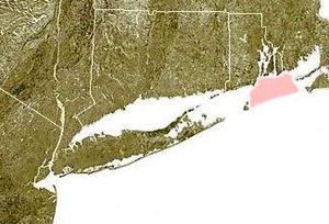
Rhode Island Sound
Encyclopedia
Rhode Island
The state of Rhode Island and Providence Plantations, more commonly referred to as Rhode Island , is a state in the New England region of the United States. It is the smallest U.S. state by area...
at mouth of Narragansett Bay
Narragansett Bay
Narragansett Bay is a bay and estuary on the north side of Rhode Island Sound. Covering 147 mi2 , the Bay forms New England's largest estuary, which functions as an expansive natural harbor, and includes a small archipelago...
. It forms the eastern extension of Long Island Sound
Long Island Sound
Long Island Sound is an estuary of the Atlantic Ocean, located in the United States between Connecticut to the north and Long Island, New York to the south. The mouth of the Connecticut River at Old Saybrook, Connecticut, empties into the sound. On its western end the sound is bounded by the Bronx...
and opens out the Atlantic Ocean
Atlantic Ocean
The Atlantic Ocean is the second-largest of the world's oceanic divisions. With a total area of about , it covers approximately 20% of the Earth's surface and about 26% of its water surface area...
between Block Island
Block Island
Block Island is part of the U.S. state of Rhode Island and is located in the Atlantic Ocean approximately south of the coast of Rhode Island, east of Montauk Point on Long Island, and is separated from the Rhode Island mainland by Block Island Sound. The United States Census Bureau defines Block...
and Martha's Vineyard
Martha's Vineyard
Martha's Vineyard is an island located south of Cape Cod in Massachusetts, known for being an affluent summer colony....
.
Geographic Information
Geographically, it is the eastward extension of Block Island SoundBlock Island Sound
Block Island Sound is a strait in the open Atlantic Ocean, approximately wide, separating Block Island from the coast of Rhode Island in the United States...
. Northeast of Rhode Island Sound is Buzzards Bay
Buzzards Bay (bay)
Buzzards Bay is a bay of the Atlantic Ocean adjacent to the U.S. state of Massachusetts. It is approximately 28 miles long by 8 miles wide. It is a popular destination for fishing, boating, and tourism. Since 1914, Buzzards Bay has been connected to Cape Cod Bay by the Cape Cod Canal...
. The Rhode Island Sound is around 2,500 km² and has a maximum depth of 60 meters. Average wave heights range from 1 to 3 meters. Circulation and current strength are mostly impacted by the surrounding geology and not by wind strength. This causes the sea floor habitats in the Rhode Island Sound to be constantly changing.
Sedimentary Processes
Recent studies from 2006 by the Coastal Marine and Geology Program and the Long Island Sound Resource Center used Digital terrain modelsDigital elevation model
A digital elevation model is a digital model or 3-D representation of a terrain's surface — commonly for a planet , moon, or asteroid — created from terrain elevation data....
to make topographical depictions of unknown glacial features and bedforms. Newfound glacial features include an ice-sculptured bedrock surface, residual stagnant-ice-contact deposits, a recessional moraine, and exposed glaciolacustrine sediments. Modern bedforms consist of fields of transverse sand waves, barchanoid waves, giant scour depressions, and pockmarks)
Pockmark (geology)
Pockmarks are craters in the seabed caused by fluids erupting and streaming through the sediments. Pockmarks were discovered off the coasts of Nova Scotia, Canada in the late 1960s by Lew King and Brian McLean of the Bedford Institute of Oceanography. As pockmarks are uncommon on the land surface,...
. Bedform asymmetry from multibeam bathymetric data indicate that net sediment transport is westward across the northern part of the study area near Fishers Island
Fishers Island
Fishers Island, approximately 9 miles long and 1 mile wide, is located at the eastern end of Long Island Sound, 2 miles off the southeastern coast of Connecticut across Fishers Island Sound...
, and eastward across the southern part near Great Gull Island
Great Gull Island
Great Gull Island is a island separating Long Island and Block Island sounds, located approximately southwest of Little Gull Island. Both islands are located in Suffolk County, New York, and lie roughly midway between Plum Island and Fishers Island....
. Compared to the Block Island Sound, the Rhode Island Sound is more prone to stratification
Stratification
Stratification is the building up of layers. Stratified is an adjective referring to the arranging of layers, and is also the past form of the verb stratify, to separate or become separated into layers...
since water currents are less dynamic in this area.
Algal and Kelp Growth
Kelp population density is higher in the Rhode Island Sound compared to other temperate locations, particularly locations north of Rhode Island. However, even though annual kelp production is higher, the productivity of individual plants is lower due to lower biomass accumulation of fucoid algae. Studies conducted by Pilson, Asare, and Harlin (1983-1985) illustrated that algal species such as Laminaria saccharinaLaminaria saccharina
Saccharina latissima is a brown algae , of the family Laminariaceae. It is also known by the common name sea belt. It is found in the north east Atlantic Ocean and the Barents Sea south to Galicia in Spain. It is not found in the Bay of Biscay but is common round the coasts of the British...
living in Rhode Island Sound waters have maximum nitrogen accumulation in their tissues, which directly correlates with maximum ambient inorganic nitrogen levels in tissues of other algal species as well. The cause of this is majorly impacted by large temporal fluctuations in the Rhode Island waters.
Invasive Species
In 2008, research conducted by the University of Rhode Island, Graduate School of Oceanography, shows that there is an increase in the abundance of a tunicateTunicate
Tunicates, also known as urochordates, are members of the subphylum Tunicata, previously known as Urochordata, a group of underwater saclike filter feeders with incurrent and excurrent siphons that is classified within the phylum Chordata. While most tunicates live on the ocean floor, others such...
species, Didemnum
Didemnum
Didemnum is a genus of tunicates in the family Didemnidae. Some species of Didemnum can be characterized as invasive species. This is particularly an issue off the east coast of the United States, where in early 2006, Didemnum were estimated to inhabit more than 175 square kilometers of this...
. The species has been spotted in the Rhode Island Sound area since 2000, but has been rapidly increasing in numbers ever since. Two certain species of jellyfish are currently having a population explosion within these waters. Mnemiopsis leidyi
Mnemiopsis leidyi
The warty comb jelly or sea walnut is a species of tentaculate ctenophore , originally native to the western Atlantic coastal waters. Three species have been named in the genus Mnemiopsis, but they are now believed to be different ecological forms of a single species M...
, commonly known as sea walnut comb jellies, and the Lion's mane jellyfish
Lion's mane jellyfish
The lion's mane jellyfish is the largest known species of jellyfish. Its range is confined to cold, boreal waters of the Arctic, northern Atlantic, and northern Pacific Oceans, seldom found farther south than 42°N latitude. Similar jellyfish, which may be the same species, are known to inhabit...
(Cyanea capillata) , are disrupting habitats with their invasive behavior in the Rhode Island Sound waters.