
Goat Rocks Wilderness
Encyclopedia
Goat Rocks Wilderness is a U.S. Wilderness Area in Washington, United States
. Consisting of portions of Mount Baker-Snoqualmie National Forest
and Gifford Pinchot National Forest
on the crest of the Cascade Range
south of U.S. Highway 12, its central feature is a number of rugged peaks, the Goat Rocks
, that are named after the numerous mountain goats that live in the area.
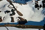
Extinct for some two million years, a volcano with an elevation of 12000 feet (3,657.6 m) once dominated this landscape. The eroded remnant of this volcano consists of rugged peaks that average over 7000 feet (2,133.6 m) elevation. The highest point among them is Gilbert Peak, at 8184 feet (2,494.5 m) with a prominence of 3664 feet (1,116.8 m). On the shaded northern slopes of the major peaks are the Packwood, McCall, Conrad and Meade Glaciers. The wilderness is drained by the North and South Forks of the Tieton
, Cispus
, and Cowlitz
Rivers and their tributaries. The lowest point in the wilderness is near Packwood Lake
at 2,920 feet (890 m).
The wilderness values of this area were first recognized on February 13, 1931, when approximately 44,500 acres (180 km2) were dedicated by the U.S. Department of Agriculture, Forest Service, as the Goat Rocks Primitive Area. In 1935, this was expanded to 72,440 acres (293 km2). In 1940, the area was increased to 82,680 acres (335 km2) and designated the Goat Rocks Wild Area by the Chief of the Forest Service.
When Congress passed the Wilderness Act
on September 3, 1964, this Wild Area became a Wilderness, part of the National Wilderness Preservation System. Congress added additional area in 1984. Forest Service management is designated to preserve and enhance the wild character of the Wilderness while providing for public use and enjoyment.
The Pacific Crest Trail
(PCT), stretching from Canada to Mexico, passes through the Goat Rocks. The Washington State portion of this trail was formerly known as the Washington Cascade Crest Trail completed in 1935. In 1968, it was designated as part of the PCT by the National Trail System Act. The Yakama Indian Reservation
, bordering the Goat rocks Wilderness on the southeast side, is closed to the general public except for the Pacific Crest Trail route.
United States
The United States of America is a federal constitutional republic comprising fifty states and a federal district...
. Consisting of portions of Mount Baker-Snoqualmie National Forest
Mount Baker-Snoqualmie National Forest
The Mount Baker-Snoqualmie National Forest in Washington extends more than along the western slopes of the Cascade Range from the Canadian border to the northern boundary of Mount Rainier National Park. Forest headquarters are located in the city of Everett....
and Gifford Pinchot National Forest
Gifford Pinchot National Forest
Gifford Pinchot National Forest is a U.S. National Forest located in southern Washington, USA. With an area of 1.37 million acres , it extends 116 km along the western slopes of Cascade Range from Mount Rainier National Park to the Columbia River. It includes the 110,000 acre Mount St....
on the crest of the Cascade Range
Cascade Range
The Cascade Range is a major mountain range of western North America, extending from southern British Columbia through Washington and Oregon to Northern California. It includes both non-volcanic mountains, such as the North Cascades, and the notable volcanoes known as the High Cascades...
south of U.S. Highway 12, its central feature is a number of rugged peaks, the Goat Rocks
Goat Rocks
The Goat Rocks are a series of rugged volcanic peaks in the Cascade Range, roughly between Mount Rainier and Mount Adams in southern Washington state. They are named after the numerous mountain goats which live in the area, and are at the core of the eponymous Goat Rocks Wilderness.- Geography and...
, that are named after the numerous mountain goats that live in the area.
 |
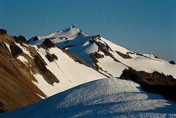 |
Extinct for some two million years, a volcano with an elevation of 12000 feet (3,657.6 m) once dominated this landscape. The eroded remnant of this volcano consists of rugged peaks that average over 7000 feet (2,133.6 m) elevation. The highest point among them is Gilbert Peak, at 8184 feet (2,494.5 m) with a prominence of 3664 feet (1,116.8 m). On the shaded northern slopes of the major peaks are the Packwood, McCall, Conrad and Meade Glaciers. The wilderness is drained by the North and South Forks of the Tieton
Tieton River
The Tieton River is a tributary of the Naches River, in Yakima County, Washington in the United States.The Tieton River begins in two forks, the North Fork Tieton River and South Fork Tieton River. The North Fork originates at McCall Glacier on the eastern sides of Old Snowy Mountain, Ives Peak,...
, Cispus
Cispus River
The Cispus River is approximately 53 miles in length and flows into the Cowlitz River at Lake Scanewa in the Cascade Mountains of Washington. Its tributaries drain most of south-central and southeastern Lewis County, extreme northeast Skamania County, and some of western Yakima County.Its main...
, and Cowlitz
Cowlitz River
The Cowlitz River is a river in the state of Washington in the United States, a tributary of the Columbia River. Its tributaries drain a large region including the slopes of Mount Rainier, Mount Adams, and Mount St. Helens....
Rivers and their tributaries. The lowest point in the wilderness is near Packwood Lake
Packwood Lake
Packwood Lake is a freshwater lake in the Gifford Pinchot National Forest in the Cascade Mountains of Washington. It is located near the town of Packwood and is a popular day hiking and overnight camping area...
at 2,920 feet (890 m).
The wilderness values of this area were first recognized on February 13, 1931, when approximately 44,500 acres (180 km2) were dedicated by the U.S. Department of Agriculture, Forest Service, as the Goat Rocks Primitive Area. In 1935, this was expanded to 72,440 acres (293 km2). In 1940, the area was increased to 82,680 acres (335 km2) and designated the Goat Rocks Wild Area by the Chief of the Forest Service.
When Congress passed the Wilderness Act
Wilderness Act
The Wilderness Act of 1964 was written by Howard Zahniser of The Wilderness Society. It created the legal definition of wilderness in the United States, and protected some 9 million acres of federal land. The result of a long effort to protect federal wilderness, the Wilderness Act was signed...
on September 3, 1964, this Wild Area became a Wilderness, part of the National Wilderness Preservation System. Congress added additional area in 1984. Forest Service management is designated to preserve and enhance the wild character of the Wilderness while providing for public use and enjoyment.
The Pacific Crest Trail
Pacific Crest Trail
The Pacific Crest Trail is a long-distance mountain hiking and equestrian trail on the Western Seaboard of the United States. The southern terminus is at the California border with Mexico...
(PCT), stretching from Canada to Mexico, passes through the Goat Rocks. The Washington State portion of this trail was formerly known as the Washington Cascade Crest Trail completed in 1935. In 1968, it was designated as part of the PCT by the National Trail System Act. The Yakama Indian Reservation
Yakama Indian Reservation
The Yakama Indian Reservation is a United States Indian reservation located on the east side of the Cascade Mountains in southern Washington. It is the homeland of the Yakama tribe of Native Americans....
, bordering the Goat rocks Wilderness on the southeast side, is closed to the general public except for the Pacific Crest Trail route.