
Keal Cotes
Encyclopedia
Keal Cotes, forming part of West Keal parish, is a small linear village
in the English county of Lincolnshire
located on the A16 road one mile (1.6 km) south of West Keal and one mile (1.6 km) north of Stickford
. The nearest market town
is Spilsby
, some six miles (9.7 km) to the north and market day is on Mondays.
The village is at the southern edge of the Lincolnshire Wolds
north of the Fenlands
, 36.5 miles (59 km) east of the county town
of Lincoln
, 12 miles (19.3 km) north east of Boston and 17 miles (27 km) west of the Holiday resort Skegness
.
The remains of a substantial Roman villa
or high status Romano-British farmhouse, the only one in Lincolnshire, are located in a large field at the south end of the village.
The name of the village is occasionally misspelt on some maps as Keal Coates.
hill fort
and defensive terraced earthworks stood at the tip of the Wolds promontory overlooking the present village. The early fortified stronghold had a commanding view of the Wash
and almost as far as modern day Spalding
across the flat marsh and boglands below.
The Keal Cotes area was visited and occupied by the Romans during the 1st century until the 4th century AD. An archeological dig and field walk in the village, during the 1960s, over a large field to the south of the village (in the corner where the A16 meets the Hagnaby Lane), discovered many tessellated
mosaic
floor tiles and roof tiles indicating that a substantial Roman villa
or high status Romano-British farmhouse had once stood on the site. Several centuries of agricultural activity had plowed out any possibility of further excavations although the cropmark outlines of an extensive dwelling can be clearly seen on several aerial photographs.
With the fens drained by the Romans the area and the village settled down to 1,500 years of rural agriculture on land ideally suited to cereal crops.
several substantial houses and cottages were built in the village under the stewardship of the Weston-Craecroft-Amcotts family as Lords of the Manor.
The Coaching inn
originally known as The Ship Inn, with its spare teams of Mail coach
horses stabled in a coach house, was built in the late 18th century. The Inn was later renamed as The Vanguard in 1876 to commemorate the sinking of HMS Vanguard
. In 1993 the public house’s name was changed for a third time and is now called The Coach House although the actual coach house building was sold separately and converted as a family home. A Victorian style conservatory was added to the pub for use as a restaurant.
Keal Cotes Post Office and village stores opened in 1795 on the same site as the village well and a 16th century farmhouse, the oldest standing building in the village. The shop and post post office was run by several generations of the local Shaw family for most of its existence. In 1923 the village telephone box was erected on a new layby outside the post office at a time when only the post office and the village blacksmith had a private telephone. The post office's telephone number was originally Spilsby 20 and later became Keal Cotes 200. The original shop and post office closed in 1995 after being downgraded to an unprofitable part time community office, with the previous shop premises being absorbed by its adjoining house now known as Orchard View. The principal factor causing the traditional levels of trade to drop was the building of the M18 motorway and the M180 motorway
in the 1970s, diverting the previously busy A16 traffic. The post office franchise moved to a small house annex at the other end of the village for several years before moving yet again to the Coach House pub where it remained until it was eventually closed by Post Office Counters Ltd as a cost saving exercise in 2005.
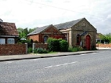
A Wesleyan Chapel and Sunday school was built in the village in 1891. Closed in the 1950s the building still stands and is now used as general storage facility by a local farmer. The village windmill, built in the 18th century, fell into decay and disuse before being demolished in 1949 and is only remembered by the naming of Mill Lane.
West Keal Primary School closed in the 1960s after the school roll fell below a sustainable level. After a fund raising campaign half of the school building was bought by the combined villages of Keal Cotes and West Keal and established as a community village hall, renamed as the "Craecroft Hall", with the other half of the building used as a private residence.
 Between 1845 and 1930 the most commonly used route between Keal Cotes and Boston was by the daily Steam Packet passenger vessel that travelled between Spilsby and Boston several times a day, also carrying the mail. The Keal Cotes wharf on the East Fen Catchwater Drain was alongside the Vanguard Bridge, with further stops in Stickford and Sibsey the route joined up with the River Trader, past Boston Golf Course to a wharf near the windmill on the Maud Foster waterway through the centre of Boston. After a final stop near the Old Blue Anchor waterside public house on Windsor Bank the steam packet turned round and headed back to Spilsby.
There was a historic footpath through the fields connecting West Keal and Keal Cotes formalised by the Enclosure Act of 1750, much used by villagers heading for the West Keal Parish Church. The footpath was annexed for its entire length by the Air Ministry
in 1941, as it passed across the perimeter track of RAF East Kirkby
, with a firm undertaking that the footpath's right of way would be reinstated as and when the airfield ever closed. However an administrative error by a junior Air Ministry clerk in 1965 resulted in the footpath being sold as several parcels of land by tender to a number of local farmers and subsequently plowed up for agriculture. Several campaigns to reopen the original footpath for public leisure use over the last 40 years, but opposed by the influential landowners, have so far failed as no local residents were still alive to attest they had regularly walked the path prior to 1941. Law changes regarding countryside access encompassed by the Countryside and Rights of Way Act 2000
mean that unless the path can be included on the definitive map by 1 January 2026 it will cease to be a right of way in perpetuity.
Mains sewerage provision finally arrived in village during 1994 although a mains gas supply has never been available, despite the high pressure Boston to Spilsby gas main pipeline passing within 50 metres of the village centre. In 2005 a speed limit of 50 miles per hour was finally imposed on the A16 main road through the village after 40 years of campaigning by the villagers and the parish council.
(25 March) among any poor in the parish by the Parish Council. As a result of the 1834 Poor Law Amendment Act
, the parish became part of the Spilsby Poor Law Union
which covered thirty three local parishes.
In 1919 a village general meeting agreed to sell the two cottages into private ownership, as annual maintenance costs were making them uneconomic. During the Second World War several of the land plots, including the verges enclosing the West Keal to Keal Cotes footpath, were compulsorily annexed by the Air Ministry
to form part of RAF East Kirkby
which adjoined the village. Over the next twenty years all of the remaining plots, with the sole exception of the triangle field, were also sold. The combined sales produced a unified cash fund that is currently invested, with the annual interest income still distributed by the commissioners of West Keal Parish Charity Fund to deserving parishioners each Christmas.
Any Keal Cotes homeless poor were housed in the Spilsby Poor Law Union Workhouse
at nearby Hundleby. The workhouse was recorded in 1870 as having 280 residents. Inmates were free to enter and leave as they liked and would receive free food and accommodation. However, the concern was that too liberal a regime would lead to many people who could easily work taking it easy in the workhouse. This would lead not only to an excessive charge on charitable funds but a dilution of the work ethic. To counter this the principle of less eligibility
was developed. Workhouse life was deliberately made as harsh and degrading as possible so that only the truly destitute would apply. Attempts were also made to provide moral guidance, training and education to the poor but it would be fair to say that the principle of less eligibility combined with the ever present desire to save money scuppered any real chance of success in this area. The workhouse was later converted into Spilsby's Gables Hospital that was demolished in 2004 to provide land for the building of new private housing.
a Conservative
.
The council is currently chaired by Vice Chairman Mr P Hubbard, after long serving chairman, Mr Fred Blackbourn, stood down from the appointment after a short illness although he continues as a lay councillor.
The Wolds comprise a series of low hills and steep valleys underlain by calcareous chalk
, green limestone
and sandstone
rock, laid down in the Cretaceous
period under a shallow warm sea. The characteristic open valleys of the Wolds were created during the last ice age
through the action of glaciation and meltwater
.
Geographically, the Lincolnshire Wolds are a continuation of the Yorkshire Wolds
which run up through the East Riding of Yorkshire
, the Wolds as a whole having been bisected by the tremendous erosive power of the waters of the Humber
. The Fenlands that stretch down as far as Norfolk
are former wetlands consisted both of peat bogs and tidal silt marshes
which were virtually all drained by the end of the 19th century when Keal Cotes had its longest period of Victorian expansion. The former peat fens and silt marshes provided a rich loamy soil that was ideal for the growing of cereal and vegetable crops and gave Lincolnshire its reputation as being the 'bread basket' of England. The resulting flat lands also made an ideal environment for the later mechanisation of farming in the mid 20th century. The soil in the village is a rich brown loamy earth over a heavy clay subsoil.
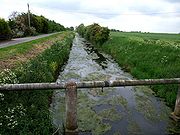
The drainage of the wetlands was organised into a combination of river and manmade drainage, aiding the passing of upland water through the region with internal drainage of the land between existing rivers. The internal drainage was designed to be organized by levels or districts each of which includes the fen parts of one or several parishes. The details of the organisation varies with the history of their development, but Keal Cotes falls within the Witham Fourth District: (East, West and Wildmore Fens and the Townland from Boston to Wainfleet). The manmade East Fen Catchwater Drain passes close to Keal Cotes ensuring that, although low lying, the possibility of flooding is almost non existent. Minor problems have occurred in recent years through farmers and householders failing to properly complete the expected annual clearing of minor feeder drains around their properties. Additionally many householders have chosen to pipe the drains through and around their gardens, greatly reducing their ability to handle higher levels of land drainage in heavy rain.
Total Population: 333 of which 49.8% were male and 50.2% were female
Average age: 43
Married or remarried: 66.2%, Single and never married 16.2% with the remainder divided between divorced, separated and widowed.
With regard to ethnicity 99.1% of the combined population is white European and 0.9% Chinese.
Christians account for 75.1%, 0.9% are Buddhist and the remainder have no stated religion.
Recent years have seen a number of commercial fishing lakes developed in the village, one of which has existed for nearly twenty years.
The Coach House public house remains open and also serves breakfasts, lunches and evening meals. The village shop and the local blacksmith’s workshop closed in the 1990s.
In 1994 the travelling Circus Harlequin
relocated its winter quarters to Hagnaby Manor at the south end of the village, now renamed Kasanga Manor after the male African lion
that died there in 1995. The manor is now home to a large collection of camels, reindeer
and llamas.
Secondary age children attend Grammar schools, Comprehensive Schools or Secondary modern schools that are located in Spilsby, Boston, Skegness, Horncastle and Stickney. School bus transport is available from the layby outside The Coach House.
and brick on a rise above the village in 1623 in the Early English and Perpendicular style, with buttresses and corners faced with Ancaster stone. The nave, with north and south aisles and clerestory, has five-bay arcades with double chamfered arches supported on hexagonal pillars. The tall tower, with battlements, pinnacles and grotesques, carries a peal of six bells.
Part of the church was rebuilt in 1866 due to the porous nature of the green sandstone that had deteriorated over two hundred years. The church tower fell down on 18 Sep 1881, but was quickly rebuilt and completed in 1884. The church clock stopped working in the 1980s and several early attempts to repair it proved to be failures. The clock was finally returned to working order just after 2001. It has been noted that if you stand on the church tower and look due East, there is nothing higher than you until you reach the Ural Mountains
in Western Russia
.
The former Wesleyan Chapel in the village is deconsecrated and closed.
Linear village
In geography, a linear village, or linear settlement, is a small to medium-sized settlement that is formed around a transport route, such as a road, river, or canal. Wraysbury, a village in Berkshire, is one of the longest villages in England....
in the English county of Lincolnshire
Lincolnshire
Lincolnshire is a county in the east of England. It borders Norfolk to the south east, Cambridgeshire to the south, Rutland to the south west, Leicestershire and Nottinghamshire to the west, South Yorkshire to the north west, and the East Riding of Yorkshire to the north. It also borders...
located on the A16 road one mile (1.6 km) south of West Keal and one mile (1.6 km) north of Stickford
Stickford
Stickford is a village and civil parish located near the A16 road, about south west of the town of Spilsby, in the East Lindsey district, of the county of Lincolnshire, England.Stickford is recorded in the Domesday Book as Stichesforde....
. The nearest market town
Market town
Market town or market right is a legal term, originating in the medieval period, for a European settlement that has the right to host markets, distinguishing it from a village and city...
is Spilsby
Spilsby
Spilsby is a market town and civil parish in Lincolnshire. England. The town is situated adjacent to the main A16 Trunk Road at the southern edge of the Lincolnshire Wolds north of the Fenlands, east of the county town of Lincoln, north east of Boston and north west from Skegness.The town has...
, some six miles (9.7 km) to the north and market day is on Mondays.
The village is at the southern edge of the Lincolnshire Wolds
Lincolnshire Wolds
The Lincolnshire Wolds is a range of hills in the county of Lincolnshire, England. It is a designated Area of Outstanding Natural Beauty , and the highest area of land in eastern England between Yorkshire and Kent...
north of the Fenlands
The Fens
The Fens, also known as the , are a naturally marshy region in eastern England. Most of the fens were drained several centuries ago, resulting in a flat, damp, low-lying agricultural region....
, 36.5 miles (59 km) east of the county town
County town
A county town is a county's administrative centre in the United Kingdom or Ireland. County towns are usually the location of administrative or judicial functions, or established over time as the de facto main town of a county. The concept of a county town eventually became detached from its...
of Lincoln
Lincoln, Lincolnshire
Lincoln is a cathedral city and county town of Lincolnshire, England.The non-metropolitan district of Lincoln has a population of 85,595; the 2001 census gave the entire area of Lincoln a population of 120,779....
, 12 miles (19.3 km) north east of Boston and 17 miles (27 km) west of the Holiday resort Skegness
Skegness
Skegness is a seaside town and civil parish in the East Lindsey district of Lincolnshire, England. Located on the Lincolnshire coast of the North Sea, east of the city of Lincoln it has a total resident population of 18,910....
.
The remains of a substantial Roman villa
Ancient Rome
Ancient Rome was a thriving civilization that grew on the Italian Peninsula as early as the 8th century BC. Located along the Mediterranean Sea and centered on the city of Rome, it expanded to one of the largest empires in the ancient world....
or high status Romano-British farmhouse, the only one in Lincolnshire, are located in a large field at the south end of the village.
The name of the village is occasionally misspelt on some maps as Keal Coates.
Early history
The area has been occupied by man since pre-historic times. Evidence for this can be found at nearby West Keal where an Iron AgeIron Age
The Iron Age is the archaeological period generally occurring after the Bronze Age, marked by the prevalent use of iron. The early period of the age is characterized by the widespread use of iron or steel. The adoption of such material coincided with other changes in society, including differing...
hill fort
Hill fort
A hill fort is a type of earthworks used as a fortified refuge or defended settlement, located to exploit a rise in elevation for defensive advantage. They are typically European and of the Bronze and Iron Ages. Some were used in the post-Roman period...
and defensive terraced earthworks stood at the tip of the Wolds promontory overlooking the present village. The early fortified stronghold had a commanding view of the Wash
The Wash
The Wash is the square-mouthed bay and estuary on the northwest margin of East Anglia on the east coast of England, where Norfolk meets Lincolnshire. It is among the largest estuaries in the United Kingdom...
and almost as far as modern day Spalding
Spalding, Lincolnshire
Spalding is a market town with a population of 30,000 on the River Welland in the South Holland district of Lincolnshire, England. Little London is a hamlet directly south of Spalding on the B1172 road....
across the flat marsh and boglands below.
The Keal Cotes area was visited and occupied by the Romans during the 1st century until the 4th century AD. An archeological dig and field walk in the village, during the 1960s, over a large field to the south of the village (in the corner where the A16 meets the Hagnaby Lane), discovered many tessellated
Tessellation
A tessellation or tiling of the plane is a pattern of plane figures that fills the plane with no overlaps and no gaps. One may also speak of tessellations of parts of the plane or of other surfaces. Generalizations to higher dimensions are also possible. Tessellations frequently appeared in the art...
mosaic
Mosaic
Mosaic is the art of creating images with an assemblage of small pieces of colored glass, stone, or other materials. It may be a technique of decorative art, an aspect of interior decoration, or of cultural and spiritual significance as in a cathedral...
floor tiles and roof tiles indicating that a substantial Roman villa
Ancient Rome
Ancient Rome was a thriving civilization that grew on the Italian Peninsula as early as the 8th century BC. Located along the Mediterranean Sea and centered on the city of Rome, it expanded to one of the largest empires in the ancient world....
or high status Romano-British farmhouse had once stood on the site. Several centuries of agricultural activity had plowed out any possibility of further excavations although the cropmark outlines of an extensive dwelling can be clearly seen on several aerial photographs.
With the fens drained by the Romans the area and the village settled down to 1,500 years of rural agriculture on land ideally suited to cereal crops.
Later development
Until the Enclosure Acts between 1750 and 1860 the village consisted of a scattered collection of small crofts and farm houses. In the Victorian eraVictorian era
The Victorian era of British history was the period of Queen Victoria's reign from 20 June 1837 until her death on 22 January 1901. It was a long period of peace, prosperity, refined sensibilities and national self-confidence...
several substantial houses and cottages were built in the village under the stewardship of the Weston-Craecroft-Amcotts family as Lords of the Manor.
The Coaching inn
Coaching inn
In Europe, from approximately the mid-17th century for a period of about 200 years, the coaching inn, sometimes called a coaching house or staging inn, was a vital part of the inland transport infrastructure, as an inn serving coach travelers...
originally known as The Ship Inn, with its spare teams of Mail coach
Mail coach
In Great Britain, the mail coach or post coach was a horse-drawn carriage that carried mail deliveries, from 1784. In Ireland, the first mail coach began service from Dublin in 1789. The coach was drawn by four horses and had seating for four passengers inside. Further passengers were later allowed...
horses stabled in a coach house, was built in the late 18th century. The Inn was later renamed as The Vanguard in 1876 to commemorate the sinking of HMS Vanguard
HMS Vanguard (1869)
The eighth HMS Vanguard of the British Royal Navy was an Audacious-class central-battery ironclad battleship, launched in 1870.Vanguard — under the command of Captain Richard Dawkins, sailed out of Kingstown harbour on 27 August 1875 in company with three other ironclads, , and...
. In 1993 the public house’s name was changed for a third time and is now called The Coach House although the actual coach house building was sold separately and converted as a family home. A Victorian style conservatory was added to the pub for use as a restaurant.
Keal Cotes Post Office and village stores opened in 1795 on the same site as the village well and a 16th century farmhouse, the oldest standing building in the village. The shop and post post office was run by several generations of the local Shaw family for most of its existence. In 1923 the village telephone box was erected on a new layby outside the post office at a time when only the post office and the village blacksmith had a private telephone. The post office's telephone number was originally Spilsby 20 and later became Keal Cotes 200. The original shop and post office closed in 1995 after being downgraded to an unprofitable part time community office, with the previous shop premises being absorbed by its adjoining house now known as Orchard View. The principal factor causing the traditional levels of trade to drop was the building of the M18 motorway and the M180 motorway
M180 motorway
The M180 motorway is a short but major motorway in England from junction 5 on the M18 motorway in the Metropolitan Borough of Doncaster to a point close to Humberside Airport some from the ports of Immingham and Grimsby and the east coast and provides access for major routes to Cleethorpes,...
in the 1970s, diverting the previously busy A16 traffic. The post office franchise moved to a small house annex at the other end of the village for several years before moving yet again to the Coach House pub where it remained until it was eventually closed by Post Office Counters Ltd as a cost saving exercise in 2005.
A Wesleyan Chapel and Sunday school was built in the village in 1891. Closed in the 1950s the building still stands and is now used as general storage facility by a local farmer. The village windmill, built in the 18th century, fell into decay and disuse before being demolished in 1949 and is only remembered by the naming of Mill Lane.
West Keal Primary School closed in the 1960s after the school roll fell below a sustainable level. After a fund raising campaign half of the school building was bought by the combined villages of Keal Cotes and West Keal and established as a community village hall, renamed as the "Craecroft Hall", with the other half of the building used as a private residence.
There was a historic footpath through the fields connecting West Keal and Keal Cotes formalised by the Enclosure Act of 1750, much used by villagers heading for the West Keal Parish Church. The footpath was annexed for its entire length by the Air Ministry
Air Ministry
The Air Ministry was a department of the British Government with the responsibility of managing the affairs of the Royal Air Force, that existed from 1918 to 1964...
in 1941, as it passed across the perimeter track of RAF East Kirkby
RAF East Kirkby
RAF East Kirkby is a former Royal Air Force base near the village of East Kirkby, south of Horncastle in Lincolnshire, just off the A155. The Greenwich meridian through the base.-History:...
, with a firm undertaking that the footpath's right of way would be reinstated as and when the airfield ever closed. However an administrative error by a junior Air Ministry clerk in 1965 resulted in the footpath being sold as several parcels of land by tender to a number of local farmers and subsequently plowed up for agriculture. Several campaigns to reopen the original footpath for public leisure use over the last 40 years, but opposed by the influential landowners, have so far failed as no local residents were still alive to attest they had regularly walked the path prior to 1941. Law changes regarding countryside access encompassed by the Countryside and Rights of Way Act 2000
Countryside and Rights of Way Act 2000
The Countryside and Rights of Way Act 2000 is a UK Act of Parliament which came into force on 30 November 2000.As of September 2007, not all sections of the Countryside and Rights of Way Act have yet come into force...
mean that unless the path can be included on the definitive map by 1 January 2026 it will cease to be a right of way in perpetuity.
Mains sewerage provision finally arrived in village during 1994 although a mains gas supply has never been available, despite the high pressure Boston to Spilsby gas main pipeline passing within 50 metres of the village centre. In 2005 a speed limit of 50 miles per hour was finally imposed on the A16 main road through the village after 40 years of campaigning by the villagers and the parish council.
Poor lands
The parish had several plots of land set aside as Poor Land, owning two adjoining cottages in the village, the Triangle Field opposite the chapel and several assorted fields. Annual revenues from these rented properties and the sale of hay cropped from the 15 metre wide verges each side of the West Keal footpath, totalling £3 11s 8d (£3.59) in 1865, were distributed annually on Lady DayLady Day
In the western Liturgical year, Lady Day is the traditional name of the Feast of the Annunciation of the Blessed Virgin in some English speaking countries. It is the first of the four traditional English quarter days. The "Lady" was the Virgin Mary. The term derives from Middle English, when some...
(25 March) among any poor in the parish by the Parish Council. As a result of the 1834 Poor Law Amendment Act
Poor Law Amendment Act 1834
The Poor Law Amendment Act 1834, sometimes abbreviated to PLAA, was an Act of the Parliament of the United Kingdom passed by the Whig government of Lord Melbourne that reformed the country's poverty relief system . It was an Amendment Act that completely replaced earlier legislation based on the...
, the parish became part of the Spilsby Poor Law Union
Poor Law Union
A Poor Law Union was a unit used for local government in the United Kingdom from the 19th century. The administration of the Poor Law was the responsibility of parishes, which varied wildly in their size, populations, financial resources, rateable values and requirements...
which covered thirty three local parishes.
In 1919 a village general meeting agreed to sell the two cottages into private ownership, as annual maintenance costs were making them uneconomic. During the Second World War several of the land plots, including the verges enclosing the West Keal to Keal Cotes footpath, were compulsorily annexed by the Air Ministry
Air Ministry
The Air Ministry was a department of the British Government with the responsibility of managing the affairs of the Royal Air Force, that existed from 1918 to 1964...
to form part of RAF East Kirkby
RAF East Kirkby
RAF East Kirkby is a former Royal Air Force base near the village of East Kirkby, south of Horncastle in Lincolnshire, just off the A155. The Greenwich meridian through the base.-History:...
which adjoined the village. Over the next twenty years all of the remaining plots, with the sole exception of the triangle field, were also sold. The combined sales produced a unified cash fund that is currently invested, with the annual interest income still distributed by the commissioners of West Keal Parish Charity Fund to deserving parishioners each Christmas.
Any Keal Cotes homeless poor were housed in the Spilsby Poor Law Union Workhouse
Workhouse
In England and Wales a workhouse, colloquially known as a spike, was a place where those unable to support themselves were offered accommodation and employment...
at nearby Hundleby. The workhouse was recorded in 1870 as having 280 residents. Inmates were free to enter and leave as they liked and would receive free food and accommodation. However, the concern was that too liberal a regime would lead to many people who could easily work taking it easy in the workhouse. This would lead not only to an excessive charge on charitable funds but a dilution of the work ethic. To counter this the principle of less eligibility
Less eligibility
Less eligibility was a condition of the Poor Law Amendment Act 1834. It was intended to make workhouses a deterrent . It stated that working conditions in the workhouse had to be worse than the worst job possible outside the workhouse...
was developed. Workhouse life was deliberately made as harsh and degrading as possible so that only the truly destitute would apply. Attempts were also made to provide moral guidance, training and education to the poor but it would be fair to say that the principle of less eligibility combined with the ever present desire to save money scuppered any real chance of success in this area. The workhouse was later converted into Spilsby's Gables Hospital that was demolished in 2004 to provide land for the building of new private housing.
Westminster
Keal Cotes and West Keal fall within Boston and Skegness Constituency and the current MP is Mark SimmondsMark Simmonds
Mark Jonathon Mortlock Simmonds is a Conservative Party politician in the United Kingdom. He is the Member of Parliament for Boston and Skegness in Lincolnshire, and was first elected in 2001, succeeding Sir Richard Body...
a Conservative
Conservative Party (UK)
The Conservative Party, formally the Conservative and Unionist Party, is a centre-right political party in the United Kingdom that adheres to the philosophies of conservatism and British unionism. It is the largest political party in the UK, and is currently the largest single party in the House...
.
Parish Council
Keal Cotes has no parish council of its own and is combined with West Keal as West Keal Parish Council. Keal Cotes provides three councillors to the Parish Council through elections every four years, or co-options if no candidates are nominated. The parish council meets monthly at the village hall.The council is currently chaired by Vice Chairman Mr P Hubbard, after long serving chairman, Mr Fred Blackbourn, stood down from the appointment after a short illness although he continues as a lay councillor.
Geography
The village is situated on flat ground at the south western rim of the attractive rolling Lincolnshire Wolds. Keal Cotes is at the northern edge of a tract of marsh and fen land, bounded by Boston deeps and the North Sea and is within seventeen miles inland from the holiday centre of Skegness, on what many consider is the best part of the Lincolnshire coast.The Wolds comprise a series of low hills and steep valleys underlain by calcareous chalk
Chalk
Chalk is a soft, white, porous sedimentary rock, a form of limestone composed of the mineral calcite. Calcite is calcium carbonate or CaCO3. It forms under reasonably deep marine conditions from the gradual accumulation of minute calcite plates shed from micro-organisms called coccolithophores....
, green limestone
Limestone
Limestone is a sedimentary rock composed largely of the minerals calcite and aragonite, which are different crystal forms of calcium carbonate . Many limestones are composed from skeletal fragments of marine organisms such as coral or foraminifera....
and sandstone
Sandstone
Sandstone is a sedimentary rock composed mainly of sand-sized minerals or rock grains.Most sandstone is composed of quartz and/or feldspar because these are the most common minerals in the Earth's crust. Like sand, sandstone may be any colour, but the most common colours are tan, brown, yellow,...
rock, laid down in the Cretaceous
Cretaceous
The Cretaceous , derived from the Latin "creta" , usually abbreviated K for its German translation Kreide , is a geologic period and system from circa to million years ago. In the geologic timescale, the Cretaceous follows the Jurassic period and is followed by the Paleogene period of the...
period under a shallow warm sea. The characteristic open valleys of the Wolds were created during the last ice age
Ice age
An ice age or, more precisely, glacial age, is a generic geological period of long-term reduction in the temperature of the Earth's surface and atmosphere, resulting in the presence or expansion of continental ice sheets, polar ice sheets and alpine glaciers...
through the action of glaciation and meltwater
Glacier
A glacier is a large persistent body of ice that forms where the accumulation of snow exceeds its ablation over many years, often centuries. At least 0.1 km² in area and 50 m thick, but often much larger, a glacier slowly deforms and flows due to stresses induced by its weight...
.
Geographically, the Lincolnshire Wolds are a continuation of the Yorkshire Wolds
Yorkshire Wolds
The Yorkshire Wolds are low hills in the counties of East Riding of Yorkshire and North Yorkshire in northeastern England. The name also applies to the district in which the hills lie....
which run up through the East Riding of Yorkshire
East Riding of Yorkshire
The East Riding of Yorkshire, or simply East Yorkshire, is a local government district with unitary authority status, and a ceremonial county of England. For ceremonial purposes the county also includes the city of Kingston upon Hull, which is a separate unitary authority...
, the Wolds as a whole having been bisected by the tremendous erosive power of the waters of the Humber
Humber
The Humber is a large tidal estuary on the east coast of Northern England. It is formed at Trent Falls, Faxfleet, by the confluence of the tidal River Ouse and the tidal River Trent. From here to the North Sea, it forms part of the boundary between the East Riding of Yorkshire on the north bank...
. The Fenlands that stretch down as far as Norfolk
Norfolk
Norfolk is a low-lying county in the East of England. It has borders with Lincolnshire to the west, Cambridgeshire to the west and southwest and Suffolk to the south. Its northern and eastern boundaries are the North Sea coast and to the north-west the county is bordered by The Wash. The county...
are former wetlands consisted both of peat bogs and tidal silt marshes
Tidal marsh
A tidal marsh is a type of marsh that is found along coasts and estuaries of which the flooding characteristics are determined by the tidal movement of the adjacent estuary, sea or ocean . According to the salinity of the flooding water, freshwater, brackish and saline tidal marshes are...
which were virtually all drained by the end of the 19th century when Keal Cotes had its longest period of Victorian expansion. The former peat fens and silt marshes provided a rich loamy soil that was ideal for the growing of cereal and vegetable crops and gave Lincolnshire its reputation as being the 'bread basket' of England. The resulting flat lands also made an ideal environment for the later mechanisation of farming in the mid 20th century. The soil in the village is a rich brown loamy earth over a heavy clay subsoil.
The drainage of the wetlands was organised into a combination of river and manmade drainage, aiding the passing of upland water through the region with internal drainage of the land between existing rivers. The internal drainage was designed to be organized by levels or districts each of which includes the fen parts of one or several parishes. The details of the organisation varies with the history of their development, but Keal Cotes falls within the Witham Fourth District: (East, West and Wildmore Fens and the Townland from Boston to Wainfleet). The manmade East Fen Catchwater Drain passes close to Keal Cotes ensuring that, although low lying, the possibility of flooding is almost non existent. Minor problems have occurred in recent years through farmers and householders failing to properly complete the expected annual clearing of minor feeder drains around their properties. Additionally many householders have chosen to pipe the drains through and around their gardens, greatly reducing their ability to handle higher levels of land drainage in heavy rain.
Demography
There are no separately published demographic figures for Keal Cotes. The only figures available from the 2001 census combine Keal Cotes and West Keal, with West Keal being the slightly larger part.Total Population: 333 of which 49.8% were male and 50.2% were female
Average age: 43
Married or remarried: 66.2%, Single and never married 16.2% with the remainder divided between divorced, separated and widowed.
With regard to ethnicity 99.1% of the combined population is white European and 0.9% Chinese.
Christians account for 75.1%, 0.9% are Buddhist and the remainder have no stated religion.
Economy
The village is predominantly a rural agricultural economy. There is little in the way of major employers in the area and the majority of employed residents commute to the commercial centres of Lincoln, Boston and Skegness.Recent years have seen a number of commercial fishing lakes developed in the village, one of which has existed for nearly twenty years.
The Coach House public house remains open and also serves breakfasts, lunches and evening meals. The village shop and the local blacksmith’s workshop closed in the 1990s.
In 1994 the travelling Circus Harlequin
Circus
A circus is commonly a travelling company of performers that may include clowns, acrobats, trained animals, trapeze acts, musicians, hoopers, tightrope walkers, jugglers, unicyclists and other stunt-oriented artists...
relocated its winter quarters to Hagnaby Manor at the south end of the village, now renamed Kasanga Manor after the male African lion
Lion
The lion is one of the four big cats in the genus Panthera, and a member of the family Felidae. With some males exceeding 250 kg in weight, it is the second-largest living cat after the tiger...
that died there in 1995. The manor is now home to a large collection of camels, reindeer
Reindeer
The reindeer , also known as the caribou in North America, is a deer from the Arctic and Subarctic, including both resident and migratory populations. While overall widespread and numerous, some of its subspecies are rare and one has already gone extinct.Reindeer vary considerably in color and size...
and llamas.
Landmarks and nearby attractions
- The Coach House
- Keal Cotes Fishing Lake
- Bolingbroke CastleBolingbroke CastleBolingbroke Castle is a ruined castle in Bolingbroke Lincolnshire, England.-Construction:Most of the castle is built of Spilsby greenstone, as are several nearby churches. The local greenstone is a limestone that proved to be porous, prone to rapid deterioration when exposed to weather and a...
- birthplace of King Henry IVHenry IV of EnglandHenry IV was King of England and Lord of Ireland . He was the ninth King of England of the House of Plantagenet and also asserted his grandfather's claim to the title King of France. He was born at Bolingbroke Castle in Lincolnshire, hence his other name, Henry Bolingbroke...
on 3 April 1367
- Gunby Hall, a national trust stately home, open on selected days during summer months
- Battle of Britain Memorial FlightBattle of Britain Memorial FlightThe Battle of Britain Memorial Flight is a Royal Air Force flight which provides an aerial display group comprising an Avro Lancaster, a Supermarine Spitfire and a Hawker Hurricane...
at nearby RAF ConingsbyRAF ConingsbyRAF Coningsby , is a Royal Air Force station in Lincolnshire, England. It has been commanded by Group Captain Martin Sampson since 10 December 2010.-Operational units:...
with its historic flying collection of an Avro LancasterAvro LancasterThe Avro Lancaster is a British four-engined Second World War heavy bomber made initially by Avro for the Royal Air Force . It first saw active service in 1942, and together with the Handley Page Halifax it was one of the main heavy bombers of the RAF, the RCAF, and squadrons from other...
bomber plus five Supermarine SpitfireSupermarine SpitfireThe Supermarine Spitfire is a British single-seat fighter aircraft that was used by the Royal Air Force and many other Allied countries throughout the Second World War. The Spitfire continued to be used as a front line fighter and in secondary roles into the 1950s...
s and two Hawker HurricaneHawker HurricaneThe Hawker Hurricane is a British single-seat fighter aircraft that was designed and predominantly built by Hawker Aircraft Ltd for the Royal Air Force...
fighters plus a DC47 Dakota transport and two Chipmunk trainers.
- Lincolnshire Aviation Heritage Centre is in East Kirkby, Spilsby on the site of RAF East Kirkby. The museum, which is open daily except Sundays, commemorates the RAFRoyal Air ForceThe Royal Air Force is the aerial warfare service branch of the British Armed Forces. Formed on 1 April 1918, it is the oldest independent air force in the world...
's presence in Lincolnshire during World War II, with notable airfields such as RAF ScamptonScamptonScampton is a village and civil parish in the West Lindsey district of Lincolnshire, England. Included in the parish is RAF Scampton. It is north of Lincoln just off the A15...
being located in the flat Lincolnshire countryside. The museum contains one of the world's three remaining Lancaster bombers still capable of flying (although it does not fly, as the privately run museum cannot afford the £2,000,000 cost of an air worthiness certificate).
- The popular Spilsby Show takes place on the town playing fields on Ancaster Avenue off Boston Road. The event is held every July and proceeds support several local charities.
- Northcote Heavy Horse Centre
- Snipedales Nature Reserve and Country Park next to the historic Civil War battlefield at nearby WincebyBattle of WincebyThe Battle of Winceby took place on 11 October 1643 during the English Civil War near the village of Winceby, Lincolnshire about 4 miles east of Horncastle.-Prelude:...
Education
There are no schools in the village. Village children attend junior schools in Stickney, Toynton All Saints and Spilsby.Secondary age children attend Grammar schools, Comprehensive Schools or Secondary modern schools that are located in Spilsby, Boston, Skegness, Horncastle and Stickney. School bus transport is available from the layby outside The Coach House.
Religious sites
The Anglican church in West Keal is dedicated to St Helen. The original church was consecrated in 1186, though little Norman work remains. The current church was built of Spilsby green sandstoneSandstone
Sandstone is a sedimentary rock composed mainly of sand-sized minerals or rock grains.Most sandstone is composed of quartz and/or feldspar because these are the most common minerals in the Earth's crust. Like sand, sandstone may be any colour, but the most common colours are tan, brown, yellow,...
and brick on a rise above the village in 1623 in the Early English and Perpendicular style, with buttresses and corners faced with Ancaster stone. The nave, with north and south aisles and clerestory, has five-bay arcades with double chamfered arches supported on hexagonal pillars. The tall tower, with battlements, pinnacles and grotesques, carries a peal of six bells.
Part of the church was rebuilt in 1866 due to the porous nature of the green sandstone that had deteriorated over two hundred years. The church tower fell down on 18 Sep 1881, but was quickly rebuilt and completed in 1884. The church clock stopped working in the 1980s and several early attempts to repair it proved to be failures. The clock was finally returned to working order just after 2001. It has been noted that if you stand on the church tower and look due East, there is nothing higher than you until you reach the Ural Mountains
Ural Mountains
The Ural Mountains , or simply the Urals, are a mountain range that runs approximately from north to south through western Russia, from the coast of the Arctic Ocean to the Ural River and northwestern Kazakhstan. Their eastern side is usually considered the natural boundary between Europe and Asia...
in Western Russia
Russia
Russia or , officially known as both Russia and the Russian Federation , is a country in northern Eurasia. It is a federal semi-presidential republic, comprising 83 federal subjects...
.
The former Wesleyan Chapel in the village is deconsecrated and closed.
Notable people
- Martin LaceyMartin LaceyMartin Lacey is a circus ringmaster, company director and trainer of wild animals. He trained most of the tigers that were used in the Esso television advertisements in the 1970s-Professional life:...
– the UK’s best known breeder of tigers who provided most of the EssoEssoEsso is an international trade name for ExxonMobil and its related companies. Pronounced , it is derived from the initials of the pre-1911 Standard Oil, and as such became the focus of much litigation and regulatory restriction in the United States. In 1972, it was largely replaced in the U.S. by...
tigers for TV adverts during the 1950s – 1990s lives in the village.
- Elizabeth Shaw - Centenarian. She was born 22 April 1683, and was living at Keal Cotes in 1800. A portrait of her by R. Sheardown from the life was published in 1800 (Wellcome Library, London, no. 1814i)