
The Fens
Encyclopedia
The Fens, also known as the , are a naturally marshy region in eastern England. Most of the fens were drained several centuries ago, resulting in a flat, damp, low-lying agricultural region.
A fen
is the local name for an individual area of marshland or former marshland and also designates the type of marsh typical of the area, which has neutral
or alkali
ne water chemistry and relatively large quantities of dissolved minerals, but few other plant nutrient
s.
The Fenland primarily lies around the coast of the Wash
; it reaches into two of the nine official regions of England
(the East of England
and the East Midlands
), four ceremonial counties
(Lincolnshire
, Cambridgeshire
, Norfolk
and a small area of Suffolk
), eleven District Councils and six postcode areas (LN
, PE
, CB, IP, NR
and NG). The whole occupies an area of nearly 1500 sq mi (3,885 km²).
Most of the Fenland lies within a few metres of sea-level. As with similar areas in the Netherlands
, much of the Fenland originally consisted of fresh- or salt-water wetlands, which have been artificially drained and continue to be protected from floods by drainage banks and pumps. With the support of this drainage system, the Fenland has become a major arable
agricultural region in Britain for grains and vegetables. The Fens are particularly fertile, containing around half of the grade 1 agricultural land
in England.
The Fens have been referred to as the "Holy Land of the English" because of the churches and cathedrals of Ely
, Ramsey
, Crowland
, Thorney
and Peterborough
.
Other significant towns in the Fens include Cambridge
, Boston
, Spalding
, Wisbech
and King's Lynn
.
 The Fens are very low-lying compared with the chalk
and limestone
uplands that surround them – in most places no more than 10 m above sea level. Indeed, as a result of drainage and the subsequent shrinkage of the peat
fens, many parts of the Fens now lie below mean sea level. Although one writer in the seventeenth century described the Fenland as all lying above sea level (in contrast to the Netherlands), the area is now home to the lowest land point in the United Kingdom, Holme Fen
in Cambridgeshire, at around 2.75 metres below sea level. Within the Fens there are a few hills, which have historically been called "islands" as they remained dry when the low-lying fens around them were flooded. The largest of the fen-islands is the Isle of Ely
, on which the cathedral city of Ely
was built; its highest point is 39 m above mean sea-level.
Without artificial drainage and flood protection, the Fens would be liable to periodic flooding, particularly in winter due to the heavy load of water flowing down from the uplands and overflowing the rivers. Some areas of the Fens were once permanently flooded, creating small lakes or meres
, while others were only flooded during periods of high water. In the pre-modern period arable farming
was limited to the higher areas of the surrounding uplands, the fen islands and the so-called Townlands, an arch of silt ground around the Wash
where the towns had their arable fields. Though these lands were lower than the peat fens before the peat shrinkage began, the more stable silt
soils were reclaimed by medieval farmers and embanked against any floods coming down from the peat areas or from the sea. The rest of the Fenland was dedicated to pastoral farming
, fishing, fowling
and the harvesting of reeds or sedge, for example for thatch. In this way, the medieval and early modern Fens stood in contrast to the rest of southern England, which was primarily an arable agricultural region.
Since the advent of modern drainage in the nineteenth and twentieth centuries, the Fens have been radically transformed, so that today arable farming has almost entirely replaced pastoral and the economy of the Fens is heavily invested in the production of crops such as grains, vegetables and some cash crops such as rapeseed
or canola
.
Drainage in the Fenland consists of both river drainage
and internal drainage of the land between the rivers. The internal drainage was organized by levels or districts, each of which includes the fen parts of one or several parishes
. The details of the organization vary with the history of their development, but the areas include:
The above were all re-drained at one time or another after the Civil War
.
These were drained in the eighteenth and nineteenth centuries.
, known in Britain as the Devensian, ten thousand years ago, Britain and continental Europe
were joined by the ridge between Friesland
and Norfolk
. The topography of the bed of the North Sea
indicates that the rivers of the southern part of eastern England flowed into the Rhine, hence through the English Channel
. From the Fens northward along the modern coast, the drainage flowed into the northern North Sea basin. As the ice melted, the rising sea level drowned the lower lands, leading ultimately to the present coastline.
These rising sea levels flooded the previously inland woodland of the Fenland basin, and over the next few thousand years led to extensive development of both salt-water and fresh-water wetlands. Silt and clay
soils were deposited by marine floods in the salt-water areas and along the beds of tidal rivers, while organic soils, or peats, developed in the fresh-water marshes. Fenland water levels peaked in the Iron Age; earlier Bronze and Neolithic settlements were covered by peat deposits, and have only recently been found. During the Roman period, water levels fell once again, and settlements were possible on the new silt soils deposited near the coast. Though water levels rose once again in the early medieval period, by this time artificial banks protected the coastal settlements and the interior from further deposits of marine silts, though peats continued to develop in the freshwater wetlands of the interior fens.
The wetlands of the fens have historically included:
Major areas for settlement were:
In general, of the three principal soil types found in the Fenland today, the mineral-based silt resulted from the energetic marine environment of the creeks, the clay was deposited in tidal mud-flats and salt-marsh, while the peat grew in the fen and bog. The peat produces black soils, which are directly comparable to the American muck soils
. A roddon
, the dried raised bed of a watercourse, is more suitable for building than the less stable peat.
Since the 19th century, all of the acid peat in the Fens has disappeared; drying and wastage of peats has greatly reduced the depth of the alkaline peat soils and reduced the overall elevation of large areas of the peat fens.
on. The evidence suggests that Mesolithic settlement in Cambridgeshire was particularly along the fen edges and on the low islands within the fens, to take advantage of the hunting and fishing opportunities of the wetlands.
, a road across the Fens to link what later became East Anglia
with what later became central England; it runs between Denver
and Peterborough. They also linked Cambridge
and Ely, but generally their road system avoided the Fens except for minor roads designed for exporting the products of the region, especially salt, beef and leather. Sheep were probably raised on the higher ground of the Townlands and fen islands, then as in the early nineteenth century. The Roman period also possibly saw some drainage efforts, including the Car Dyke
along the western edge of the Fenland between Peterborough and Lincolnshire, but most canals were constructed for transportation.
How far seaward the Roman settlement extended is unclear owing to the deposits laid down above them during later floods.
, Spalding
, Swineshead and Boston. All the Townlands parishes were laid out as elongated strips, to provide access to the products of fen, marsh and sea. On the fen edge, parishes are similarly elongated to provide access to both upland and fen. The townships are therefore often nearer to each other than they are to the distant farms in their own parishes.
may have moved west into the Fens to avoid the Angles
, who were migrating across the North Sea from Angeln
(modern Schleswig
) and settling what would become East Anglia
. Surrounded by water and marshes, the Fens provided a safe area that was easily defended and not particularly desirable to invading Anglo-Saxons
.
A minority believes that the names of West Walton
, Walsoken
and Walpole
hint at the native British population, the Wal- coming from the Old English walh, meaning "foreigner". However, the villages are in close proximity to the old Roman sea wall, so the wal- element is more probably from wal or weal, meaning "wall". Walton is generally believed to mean "wall-town", Walsoken to mean "the district under particular jurisdiction by the wall" and Walpole to mean simply "wall-pole" (Old English wal and pal) or perhaps "well pool" (Old English welle and pol).
When written records resume in Anglo-Saxon England, the names of a number of peoples of the Fens are recorded in the Tribal Hidage
and Christian histories. They include North Gyrwe
(Peterborough and Crowland), South Gyrwe (Ely), the Spalda (Spalding), and Bilmingas (part of south Lincolnshire).
In the early Christian period of Anglo-Saxon England, a number of Christians sought the isolation that could be found in the wilderness that the Fens had become. These saints, often with close royal links, include Guthlac, Etheldreda, Pega
, and Wendreda. Hermitages on the islands became centres of communities which later became monasteries with massive estates. In the Life of Saint Guthlac – a biography of the East Anglian hermit
who lived in the Fens during the early 8th century – it is stated that Saint Guthlac was attacked on several occasions by people he believed were Britons living in the Fens at that time. However, Bertram Colgrave, in the introduction to one edition, doubts it because of the lack of evidence of British survival in the region and the fact that British place names in the area are "very few".
Monastic life was disrupted by Danish raids and settlement, but was revived in the mid-10th century monastic revival. In the 11th century the whole area was incorporated into a united Anglo-Saxon England. It remained a place of refuge and intrigue. It was here that Alfred Aetheling was brought to be murdered and here where Hereward the Wake
based his insurgency against Norman England.
Fenland monastic houses include the so-called Fen Five (Ely Cathedral Priory
, Thorney Abbey
, Croyland Abbey
, Ramsey Abbey
and Peterborough Abbey
) as well as Spalding Abbey. As major landowners, the monasteries played a significant part in the early efforts at drainage of the Fens.
. The area was enclosed by a line from Spalding, along the River Welland to Market Deeping
, then along the Car Dyke to Dowsby
and across the fens to the Welland. It was deforested in the early thirteenth century. There is little agreement as to the exact dates of the establishment and demise of the forest, but it seems likely that the deforestation was connected with the Magna Carta
or one of its early thirteenth century restatements, though it may have been as late as 1240. The forest would have affected the economies of the townships around it and it appears that the present Bourne Eau
was constructed at the time of the deforestation
, as the town
seems to have joined in the general prosperity by about 1280.
Though the forest was about half in Holland (Lincolnshire)
and half in Kesteven
, it is known as Kesteven Forest.
to do so. The leader of one of these syndicates was the Earl of Bedford, who employed Cornelius Vermuyden
as engineer. Contrary to popular belief, Vermuyden was not involved with the draining of the Great Fen in Cambridgeshire and Norfolk in the 1630s, but only became involved with the second phase of construction in the 1650s. The scheme was imposed despite huge opposition from locals who were losing their livelihoods in favour of already great landowners.
Two cuts were made in the Cambridgeshire Fens to join the River Great Ouse
to the sea at King's Lynn – the Old Bedford River
and the New Bedford River
, the latter being known also as the Hundred Foot Drain. Both cuts were named after the Fourth Earl of Bedford
who, along with some gentlemen adventurers (venture capitalists), funded the construction and were rewarded with large grants of the resulting farmland. The work was directed by engineers from the Low Countries
. Following this initial drainage, the Fens were still extremely susceptible to flooding, so windpump
s were used to pump water away from affected areas.
However, their success was short-lived. Once drained of water, the peat shrank, and the fields lowered further. The more effectively they were drained, the worse the problem became, and soon the fields were lower than the surrounding rivers. By the end of the 17th century, the land was under water once again.
Though the three Bedford Levels together formed the biggest scheme, they were not the only ones. Lord Lindsey
and his partner Sir William Killigrew
had the Lindsey Level inhabited by farmers by 1638, but the onset of the Civil War permitted the destruction of the works until the 1765 Act of Parliament
that led to the formation of the Black Sluice Commissioners.
Many original records of the Bedford Level Corporation, including maps of the Levels, are now held by Cambridgeshire Archives and Local Studies
Service at the County Record Office in Cambridge.
 The major part of the draining of the Fens was effected in the late 18th and early 19th century, again involving fierce local rioting and sabotage of the works. The final success came in the 1820s when windpumps were replaced with powerful coal-powered steam engine
s, such as Stretham Old Engine
, which were themselves replaced with diesel-powered pumps and, following World War II
, the small electric stations that are still used today.
The dead vegetation of the peat remained undecayed because it was deprived of air (the peat being anaerobic). When it was drained, the oxygen of the air reached it, since when the peat has been slowly oxidizing. This, together with the shrinkage on its initial drying and the removal of soil by the wind, has meant that much of the Fens lies below high tide level
. As the highest parts of the drained fen are now only a few metres above mean sea level, only sizeable embankments of the rivers, and general flood defences, stop the land from being inundated. Nonetheless, these works are now much more effective than they were. The question of rising sea level under the influence of global warming
remains.
The Fens today are protected by 60 miles (96.6 km) of embankments defending against the sea and 96 miles (154.5 km) of river embankments. Eleven internal drainage board
(IDB) groups maintain 286 pumping stations and 3800 miles (6,115.5 km) of watercourses, with the combined capacity to pump 16,500 Olympic-size swimming pools in a 24-hour period or to empty Rutland Water
in 3 days.
Over 70% of the Fens is involved in environmental stewardship schemes, under which 270 miles (434.5 km) of hedgerow and 1780 miles (2,864.6 km) of ditches are managed, providing large wildlife corridors and habitat for endangered animals such as the water vole.
s. By introducing fresh water, the organizers of the project hope to encourage species such as the snipe
, lapwing
and bittern. Endangered species such as the fen violet
will be seeded.
The Fens Waterways Link
is a scheme to restore navigation to some of the drainage works. It is planned to bring the South Forty-Foot Drain
and parts of the Car Dyke into use as part of a route between Boston and Cambridge.
Ancient sites include:
The following novels, or substantial portions of them, are set in the Fens:
Some films have large portions set in the Fenlands:
At least one video game has also been set in the Fens:
A fen
Fen
A fen is a type of wetland fed by mineral-rich surface water or groundwater. Fens are characterised by their water chemistry, which is neutral or alkaline, with relatively high dissolved mineral levels but few other plant nutrients...
is the local name for an individual area of marshland or former marshland and also designates the type of marsh typical of the area, which has neutral
PH
In chemistry, pH is a measure of the acidity or basicity of an aqueous solution. Pure water is said to be neutral, with a pH close to 7.0 at . Solutions with a pH less than 7 are said to be acidic and solutions with a pH greater than 7 are basic or alkaline...
or alkali
Alkali
In chemistry, an alkali is a basic, ionic salt of an alkali metal or alkaline earth metal element. Some authors also define an alkali as a base that dissolves in water. A solution of a soluble base has a pH greater than 7. The adjective alkaline is commonly used in English as a synonym for base,...
ne water chemistry and relatively large quantities of dissolved minerals, but few other plant nutrient
Plant nutrition
'Plant Nutrition is the study of the chemical elements that are necessary for growth. In 1972, E. Epstein defined 2 criteria for an element to be essential for plant growth:# in its absence the plant is unable to complete a normal life cycle or...
s.
The Fenland primarily lies around the coast of the Wash
The Wash
The Wash is the square-mouthed bay and estuary on the northwest margin of East Anglia on the east coast of England, where Norfolk meets Lincolnshire. It is among the largest estuaries in the United Kingdom...
; it reaches into two of the nine official regions of England
Regions of England
In England, the region is the highest tier of sub-national division used by central Government. Between 1994 and 2011, the nine regions had an administrative role in the implementation of UK Government policy, and as the areas covered by elected bodies...
(the East of England
East of England
The East of England is one of the nine official regions of England. It was created in 1994 and was adopted for statistics from 1999. It includes the ceremonial counties of Essex, Hertfordshire, Bedfordshire, Cambridgeshire, Norfolk and Suffolk. Essex has the highest population in the region.Its...
and the East Midlands
East Midlands
The East Midlands is one of the regions of England, consisting of most of the eastern half of the traditional region of the Midlands. It encompasses the combined area of Nottinghamshire, Derbyshire, Leicestershire, Rutland, Northamptonshire and most of Lincolnshire...
), four ceremonial counties
Ceremonial counties of England
The ceremonial counties are areas of England to which are appointed a Lord Lieutenant, and are defined by the government as counties and areas for the purposes of the Lieutenancies Act 1997 with reference to the metropolitan and non-metropolitan counties of England and Lieutenancies Act 1997...
(Lincolnshire
Lincolnshire
Lincolnshire is a county in the east of England. It borders Norfolk to the south east, Cambridgeshire to the south, Rutland to the south west, Leicestershire and Nottinghamshire to the west, South Yorkshire to the north west, and the East Riding of Yorkshire to the north. It also borders...
, Cambridgeshire
Cambridgeshire
Cambridgeshire is a county in England, bordering Lincolnshire to the north, Norfolk to the northeast, Suffolk to the east, Essex and Hertfordshire to the south, and Bedfordshire and Northamptonshire to the west...
, Norfolk
Norfolk
Norfolk is a low-lying county in the East of England. It has borders with Lincolnshire to the west, Cambridgeshire to the west and southwest and Suffolk to the south. Its northern and eastern boundaries are the North Sea coast and to the north-west the county is bordered by The Wash. The county...
and a small area of Suffolk
Suffolk
Suffolk is a non-metropolitan county of historic origin in East Anglia, England. It has borders with Norfolk to the north, Cambridgeshire to the west and Essex to the south. The North Sea lies to the east...
), eleven District Councils and six postcode areas (LN
LN postcode area
The LN postcode area, also known as the Lincoln postcode area, is a group of postcode districts around Alford, Horncastle, Lincoln, Louth, Mablethorpe, Market Rasen and Woodhall Spa in England.-Coverage:...
, PE
PE postcode area
The PE postcode area, also known as the Peterborough postcode area, is a group of postcode districts covering a large area in eastern England, including Peterborough and Huntingdon in Cambridgeshire, King's Lynn in Norfolk and Boston and Stamford in Lincolnshire. Parts of East Northamptonshire also...
, CB, IP, NR
NR postcode area
The NR postcode area, also known as the Norwich postcode area, is a group of postcode districts covering much of Norfolk and parts of the adjacent county of Suffolk in the East Anglian area of England.-Coverage:...
and NG). The whole occupies an area of nearly 1500 sq mi (3,885 km²).
Most of the Fenland lies within a few metres of sea-level. As with similar areas in the Netherlands
Netherlands
The Netherlands is a constituent country of the Kingdom of the Netherlands, located mainly in North-West Europe and with several islands in the Caribbean. Mainland Netherlands borders the North Sea to the north and west, Belgium to the south, and Germany to the east, and shares maritime borders...
, much of the Fenland originally consisted of fresh- or salt-water wetlands, which have been artificially drained and continue to be protected from floods by drainage banks and pumps. With the support of this drainage system, the Fenland has become a major arable
Arable land
In geography and agriculture, arable land is land that can be used for growing crops. It includes all land under temporary crops , temporary meadows for mowing or pasture, land under market and kitchen gardens and land temporarily fallow...
agricultural region in Britain for grains and vegetables. The Fens are particularly fertile, containing around half of the grade 1 agricultural land
Agricultural Land Classification
The Agricultural Land Classification system forms part of the planning system in England and Wales. It classifies agricultural land in five categories according to versatility and suitability for growing crops. The top three grades, Grade 1, 2 and 3a, are referred to as 'Best and Most Versatile'...
in England.
The Fens have been referred to as the "Holy Land of the English" because of the churches and cathedrals of Ely
Ely, Cambridgeshire
Ely is a cathedral city in Cambridgeshire, England, 14 miles north-northeast of Cambridge and about by road from London. It is built on a Lower Greensand island, which at a maximum elevation of is the highest land in the Fens...
, Ramsey
Ramsey, Cambridgeshire
Ramsey is a small Cambridgeshire market town and parish, north of Huntingdon and St Ives. For local government purposes it lies in the district of Huntingdonshire within the local government county of Cambridgeshire....
, Crowland
Crowland
Crowland or Croyland is a small town in south Lincolnshire, England, positioned between Peterborough and Spalding, with two sites of historical interest.-Geography:...
, Thorney
Thorney, Cambridgeshire
Thorney is a village about 8 miles east of Peterborough in the City of Peterborough unitary authority, England, on the A47. Historically it was part of the Isle of Ely, which was considered part of Cambridgeshire but was transferred into the former county of Huntingdon and Peterborough and...
and Peterborough
Peterborough
Peterborough is a cathedral city and unitary authority area in the East of England, with an estimated population of in June 2007. For ceremonial purposes it is in the county of Cambridgeshire. Situated north of London, the city stands on the River Nene which flows into the North Sea...
.
Other significant towns in the Fens include Cambridge
Cambridge
The city of Cambridge is a university town and the administrative centre of the county of Cambridgeshire, England. It lies in East Anglia about north of London. Cambridge is at the heart of the high-technology centre known as Silicon Fen – a play on Silicon Valley and the fens surrounding the...
, Boston
Boston, Lincolnshire
Boston is a town and small port in Lincolnshire, on the east coast of England. It is the largest town of the wider Borough of Boston local government district and had a total population of 55,750 at the 2001 census...
, Spalding
Spalding, Lincolnshire
Spalding is a market town with a population of 30,000 on the River Welland in the South Holland district of Lincolnshire, England. Little London is a hamlet directly south of Spalding on the B1172 road....
, Wisbech
Wisbech
Wisbech is a market town, inland port and civil parish with a population of 20,200 in the Fens of Cambridgeshire. The tidal River Nene runs through the centre of the town and is spanned by two bridges...
and King's Lynn
King's Lynn
King's Lynn is a sea port and market town in the ceremonial county of Norfolk in the East of England. It is situated north of London and west of Norwich. The population of the town is 42,800....
.
Introduction
Chalk
Chalk is a soft, white, porous sedimentary rock, a form of limestone composed of the mineral calcite. Calcite is calcium carbonate or CaCO3. It forms under reasonably deep marine conditions from the gradual accumulation of minute calcite plates shed from micro-organisms called coccolithophores....
and limestone
Limestone
Limestone is a sedimentary rock composed largely of the minerals calcite and aragonite, which are different crystal forms of calcium carbonate . Many limestones are composed from skeletal fragments of marine organisms such as coral or foraminifera....
uplands that surround them – in most places no more than 10 m above sea level. Indeed, as a result of drainage and the subsequent shrinkage of the peat
Peat
Peat is an accumulation of partially decayed vegetation matter or histosol. Peat forms in wetland bogs, moors, muskegs, pocosins, mires, and peat swamp forests. Peat is harvested as an important source of fuel in certain parts of the world...
fens, many parts of the Fens now lie below mean sea level. Although one writer in the seventeenth century described the Fenland as all lying above sea level (in contrast to the Netherlands), the area is now home to the lowest land point in the United Kingdom, Holme Fen
Holme, Cambridgeshire
Holme is a village in Huntingdonshire , England, near Conington and Yaxley, and south of Peterborough.- The village :...
in Cambridgeshire, at around 2.75 metres below sea level. Within the Fens there are a few hills, which have historically been called "islands" as they remained dry when the low-lying fens around them were flooded. The largest of the fen-islands is the Isle of Ely
Isle of Ely
The Isle of Ely is a historic region around the city of Ely now in Cambridgeshire, England but previously a county in its own right.-Etymology:...
, on which the cathedral city of Ely
Ely, Cambridgeshire
Ely is a cathedral city in Cambridgeshire, England, 14 miles north-northeast of Cambridge and about by road from London. It is built on a Lower Greensand island, which at a maximum elevation of is the highest land in the Fens...
was built; its highest point is 39 m above mean sea-level.
Without artificial drainage and flood protection, the Fens would be liable to periodic flooding, particularly in winter due to the heavy load of water flowing down from the uplands and overflowing the rivers. Some areas of the Fens were once permanently flooded, creating small lakes or meres
Mere (lake)
Mere in English refers to a lake that is broad in relation to its depth, e.g. Martin Mere. A significant effect of its shallow depth is that for all or most of the time, it has no thermocline.- Etymology :...
, while others were only flooded during periods of high water. In the pre-modern period arable farming
Agronomy
Agronomy is the science and technology of producing and using plants for food, fuel, feed, fiber, and reclamation. Agronomy encompasses work in the areas of plant genetics, plant physiology, meteorology, and soil science. Agronomy is the application of a combination of sciences like biology,...
was limited to the higher areas of the surrounding uplands, the fen islands and the so-called Townlands, an arch of silt ground around the Wash
The Wash
The Wash is the square-mouthed bay and estuary on the northwest margin of East Anglia on the east coast of England, where Norfolk meets Lincolnshire. It is among the largest estuaries in the United Kingdom...
where the towns had their arable fields. Though these lands were lower than the peat fens before the peat shrinkage began, the more stable silt
Silt
Silt is granular material of a size somewhere between sand and clay whose mineral origin is quartz and feldspar. Silt may occur as a soil or as suspended sediment in a surface water body...
soils were reclaimed by medieval farmers and embanked against any floods coming down from the peat areas or from the sea. The rest of the Fenland was dedicated to pastoral farming
Pastoral farming
Pastoral farming is farming aimed at producing livestock, rather than growing crops. Examples include dairy farming, raising beef cattle, and raising sheep for wool. In contrast, mixed farming is growing of both crops and livestock on the same farm. Pastoral farmers are also known as graziers...
, fishing, fowling
Fowling
Fowling is a term which is perhaps better known in the Fens of eastern England than elsewhere. It was more than the commercial equivalent of the field sport of wildfowling, in that it includes all forms of bird catching for meat, feathers or any other part of the bird which may have been sold on...
and the harvesting of reeds or sedge, for example for thatch. In this way, the medieval and early modern Fens stood in contrast to the rest of southern England, which was primarily an arable agricultural region.
Since the advent of modern drainage in the nineteenth and twentieth centuries, the Fens have been radically transformed, so that today arable farming has almost entirely replaced pastoral and the economy of the Fens is heavily invested in the production of crops such as grains, vegetables and some cash crops such as rapeseed
Rapeseed
Rapeseed , also known as rape, oilseed rape, rapa, rappi, rapaseed is a bright yellow flowering member of the family Brassicaceae...
or canola
Canola
Canola refers to a cultivar of either Rapeseed or Field Mustard . Its seeds are used to produce edible oil suitable for consumption by humans and livestock. The oil is also suitable for use as biodiesel.Originally, Canola was bred naturally from rapeseed in Canada by Keith Downey and Baldur R...
.
Drainage in the Fenland consists of both river drainage
Drainage basin
A drainage basin is an extent or an area of land where surface water from rain and melting snow or ice converges to a single point, usually the exit of the basin, where the waters join another waterbody, such as a river, lake, reservoir, estuary, wetland, sea, or ocean...
and internal drainage of the land between the rivers. The internal drainage was organized by levels or districts, each of which includes the fen parts of one or several parishes
Civil parish
In England, a civil parish is a territorial designation and, where they are found, the lowest tier of local government below districts and counties...
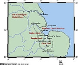
. The details of the organization vary with the history of their development, but the areas include:
- The Great Level of the Fens is the largest region of fen in eastern England: including the lower drainage basins of the River NeneRiver NeneThe River Nene is a river in the east of England that rises from three sources in the county of Northamptonshire. The tidal river forms the border between Cambridgeshire and Norfolk for about . It is the tenth longest river in the United Kingdom, and is navigable for from Northampton to The...
and the Great Ouse, it covers approximately 500 sq mi (1,295 km²). It is also known as the Bedford Level, after Francis Russell, 4th Earl of BedfordFrancis Russell, 4th Earl of BedfordFrancis Russell, 4th Earl of Bedford PC was an English politician. About 1631 he built the square of Covent Garden, with the piazza and church of St. Paul's, employing Inigo Jones as his architect...
, who headed the so-called adventurers (investors) in the seventeenth century drainage in this area; his sonWilliam Russell, 1st Duke of BedfordWilliam Russell, 1st Duke of Bedford KG PC was an English politician who sat in the House of Commons from 1640 until 1641 when he inherited his Peerage and sat in the House of Lords...
became the first governor of the Bedford Level Corporation. In the seventeenth century, the Great Level was divided into the North, Middle and South Levels for the purposes of administration and maintenance. In the twentieth century, these levels have gained new boundaries, and include some fens which were never part of the jurisdiction of the Bedford Level Corporation.- The South Level lies to the southeast of the Ouse WashesOuse WashesThe Ouse Washes are an area in the Fens of Cambridgeshire and Norfolk, England. They cover the area between two diversion channels of the River Great Ouse: the Old Bedford River and the New Bedford River .-History:...
and surrounds Ely, as it did in the seventeenth century. - The Middle Level currently lies between the Ouse Washes and the Nene, but historically lay between the Ouse Washes and Morton's Leam, a fifteenth century canal which runs north of the town of WhittleseyWhittleseyWhittlesey, historically known as Whittlesea as the name of the railway station is still spelt, or Witesie, is an ancient Fenland market town around six miles east of Peterborough in the county of Cambridgeshire in England...
. - The North Level now includes all of the fens in Cambridgeshire and LincolnshireLincolnshireLincolnshire is a county in the east of England. It borders Norfolk to the south east, Cambridgeshire to the south, Rutland to the south west, Leicestershire and Nottinghamshire to the west, South Yorkshire to the north west, and the East Riding of Yorkshire to the north. It also borders...
between the Nene and the River WellandRiver WellandThe River Welland is a river in the east of England, some long. It rises in the Hothorpe Hills, at Sibbertoft in Northamptonshire, then flows generally northeast to Market Harborough, Stamford and Spalding, to reach The Wash near Fosdyke. For much of its length it forms the county boundary between...
, but originally included only a small part of these lands, including those of the ancient parishes of ThorneyThorney, CambridgeshireThorney is a village about 8 miles east of Peterborough in the City of Peterborough unitary authority, England, on the A47. Historically it was part of the Isle of Ely, which was considered part of Cambridgeshire but was transferred into the former county of Huntingdon and Peterborough and...
and CrowlandCrowlandCrowland or Croyland is a small town in south Lincolnshire, England, positioned between Peterborough and Spalding, with two sites of historical interest.-Geography:...
, but excluding most of Wisbech Hundred and Lincolnshire, which were under their own local jurisdictions.
- The South Level lies to the southeast of the Ouse Washes
- Deeping FenDeeping FenDeeping Fen is a low-lying area in Lincolnshire in the east of England, which covers around . It is bounded by the River Welland and the River Glen, and is extensively drained, but the efficient drainage of the land exercised the minds of several of the great civil engineers of the 17th and 18th...
, in the southern part of Lincolnshire, lies between the River Welland and the River GlenRiver Glen, LincolnshireThe River Glen is a river in Lincolnshire, England with a short stretch passing through Rutland near Essendine.The river's name appears to derive from a Brythonic Celtic language but there is a strong early English connection.-Naming:...
with its tributary the Bourne EauBourne EauBourne Eau is a short river which rises in the town of Bourne in Lincolnshire, England, and flows in an easterly direction to join the River Glen at Tongue End. It is an embanked river, as its normal level is higher than that of the surrounding Fens...
. - The Black SluiceBlack SluiceThe Black Sluice is the name given to the structure that controls the flow of the South Forty-Foot Drain into The Haven, at Boston, Lincolnshire, England.-History and ownership:...
District, much of which was known as the Lindsey Level when it was first drained in 1639, extends from the Glen and Bourne Eau to SwinesheadSwineshead, LincolnshireNot to be confused with Swineshead, BedfordshireSwineshead is a village and civil parish in Lincolnshire, England, around miles west of the town of Boston...
. Its water is carried through to the HavenThe Haven, BostonThe Haven is the tidal river of the Port of Boston, Lincolnshire in England. It provides access for shipping between Boston Deeps in The Wash and the town, particularly, the dock. It also serves as the outfall into the sea, of the River Witham and of several major land drains of the northern Fens...
at BostonBoston, LincolnshireBoston is a town and small port in Lincolnshire, on the east coast of England. It is the largest town of the wider Borough of Boston local government district and had a total population of 55,750 at the 2001 census...
.
The above were all re-drained at one time or another after the Civil War
English Civil War
The English Civil War was a series of armed conflicts and political machinations between Parliamentarians and Royalists...
.
- The Witham Commission Fens:
- First District: from WashingboroughWashingboroughWashingborough is a large village east of the city of Lincoln in North Kesteven, located on the lower slopes of the limestone escarpment known as the Lincoln Cliff where the River Witham breaks through the Lincoln Edge.-Geography:...
to BillinghayBillinghayBillinghay is a village and civil parish in the North Kesteven district of Lincolnshire, England, about ten miles north-east of Sleaford. The village lies along the B1189 road near the junction with the A153. Just south of the village towards Sleaford is North Kyme...
Dales; - Second District: Blacksluice – Holland FenHolland FenHolland Fen is a settlement about north-west of the town of Boston, Lincolnshire, England.-History:Holland Fen has been known as the Haute Huntre, or Eight Hundred Fen....
; - Third District: north of the River WithamRiver WithamThe River Witham is a river, almost entirely in the county of Lincolnshire, in the east of England. It rises south of Grantham close to South Witham, at SK8818, passes Lincoln at SK9771 and at Boston, TF3244, flows into The Haven, a tidal arm of The Wash, near RSPB Frampton Marsh...
above BardneyBardneyBardney is a village and Civil Parish east of Lincoln, sitting on the north side of the River Witham in the West Lindsey district of Lincolnshire, England.-The village:...
; - Fourth District: East, West and Wildmore Fens and the Townland from Boston to WainfleetWainfleet, LincolnshireWainfleet All Saints is an ancient port and market town on the east coast of Lincolnshire, England, situated on the B1195 between Spilsby and Boston. The town stands on the small rivers Steeping and Limb that form Wainfleet Haven. The town is close to Skegness, Boston, Spilsby, the Lincolnshire...
; - Fifth District: Kyme Eau to BillinghayBillinghayBillinghay is a village and civil parish in the North Kesteven district of Lincolnshire, England, about ten miles north-east of Sleaford. The village lies along the B1189 road near the junction with the A153. Just south of the village towards Sleaford is North Kyme...
Skirth; - Sixth District: Blacksluice – Helpringham Eau to Kyme Eau.
- First District: from Washingborough
These were drained in the eighteenth and nineteenth centuries.
Formation and geography
At the end of the most recent glacial periodIce age
An ice age or, more precisely, glacial age, is a generic geological period of long-term reduction in the temperature of the Earth's surface and atmosphere, resulting in the presence or expansion of continental ice sheets, polar ice sheets and alpine glaciers...
, known in Britain as the Devensian, ten thousand years ago, Britain and continental Europe
Continental Europe
Continental Europe, also referred to as mainland Europe or simply the Continent, is the continent of Europe, explicitly excluding European islands....
were joined by the ridge between Friesland
Friesland
Friesland is a province in the north of the Netherlands and part of the ancient region of Frisia.Until the end of 1996, the province bore Friesland as its official name. In 1997 this Dutch name lost its official status to the Frisian Fryslân...
and Norfolk
Norfolk
Norfolk is a low-lying county in the East of England. It has borders with Lincolnshire to the west, Cambridgeshire to the west and southwest and Suffolk to the south. Its northern and eastern boundaries are the North Sea coast and to the north-west the county is bordered by The Wash. The county...
. The topography of the bed of the North Sea
North Sea
In the southwest, beyond the Straits of Dover, the North Sea becomes the English Channel connecting to the Atlantic Ocean. In the east, it connects to the Baltic Sea via the Skagerrak and Kattegat, narrow straits that separate Denmark from Norway and Sweden respectively...
indicates that the rivers of the southern part of eastern England flowed into the Rhine, hence through the English Channel
English Channel
The English Channel , often referred to simply as the Channel, is an arm of the Atlantic Ocean that separates southern England from northern France, and joins the North Sea to the Atlantic. It is about long and varies in width from at its widest to in the Strait of Dover...
. From the Fens northward along the modern coast, the drainage flowed into the northern North Sea basin. As the ice melted, the rising sea level drowned the lower lands, leading ultimately to the present coastline.
These rising sea levels flooded the previously inland woodland of the Fenland basin, and over the next few thousand years led to extensive development of both salt-water and fresh-water wetlands. Silt and clay
Clay
Clay is a general term including many combinations of one or more clay minerals with traces of metal oxides and organic matter. Geologic clay deposits are mostly composed of phyllosilicate minerals containing variable amounts of water trapped in the mineral structure.- Formation :Clay minerals...
soils were deposited by marine floods in the salt-water areas and along the beds of tidal rivers, while organic soils, or peats, developed in the fresh-water marshes. Fenland water levels peaked in the Iron Age; earlier Bronze and Neolithic settlements were covered by peat deposits, and have only recently been found. During the Roman period, water levels fell once again, and settlements were possible on the new silt soils deposited near the coast. Though water levels rose once again in the early medieval period, by this time artificial banks protected the coastal settlements and the interior from further deposits of marine silts, though peats continued to develop in the freshwater wetlands of the interior fens.
The wetlands of the fens have historically included:
- WashArroyo (creek)An arroyo , a Spanish word translated as brook, and also called a wash is usually a dry creek or stream bed—gulch that temporarily or seasonally fills and flows after sufficient rain. Wadi is a similar term in Africa. In Spain, a rambla has a similar meaning to arroyo.-Types and processes:Arroyos...
es: these are places such as tidal mud flats and braided riverBraided riverA braided river is one of a number of channel types and has a channel that consists of a network of small channels separated by small and often temporary islands called braid bars or, in British usage, aits or eyots. Braided streams occur in rivers with high slope and/or large sediment load...
s, which are sometimes exposed and at other times covered with water. - Salt marshSalt marshA salt marsh is an environment in the upper coastal intertidal zone between land and salt water or brackish water, it is dominated by dense stands of halophytic plants such as herbs, grasses, or low shrubs. These plants are terrestrial in origin and are essential to the stability of the salt marsh...
: this is the higher part of a tidal wash, on which salt-adapted plants grew. - FenFenA fen is a type of wetland fed by mineral-rich surface water or groundwater. Fens are characterised by their water chemistry, which is neutral or alkaline, with relatively high dissolved mineral levels but few other plant nutrients...
: this is a broad expanse of nutrient-rich shallow water in which dead plants do not fully decay, resulting in a flora of emergent plants growing in saturated peat. - MoorMoorlandMoorland or moor is a type of habitat, in the temperate grasslands, savannas, and shrublands biome, found in upland areas, characterised by low-growing vegetation on acidic soils and heavy fog...
: this developed where the peat grew above the reach of the land water which carried the nutrients to the fen. Its development was enabled where the fen was watered directly by rainfall. The slightly acidic rain washed the hydroxyl ions out of the peat, making it more suitable for acid-loving plants, notably SphagnumSphagnumSphagnum is a genus of between 151 and 350 species of mosses commonly called peat moss, due to its prevalence in peat bogs and mires. A distinction is made between sphagnum moss, the live moss growing on top of a peat bog on one hand, and sphagnum peat moss or sphagnum peat on the other, the...
species. This is exactly the same as bogBogA bog, quagmire or mire is a wetland that accumulates acidic peat, a deposit of dead plant material—often mosses or, in Arctic climates, lichens....
, but the word moor was applied to this acid peatland occurring on hills. These moors disappeared in the nineteenth century, and it had been thought that the Fenland did not have this kind of peat, until archeological and documentary evidence demonstrated that it did until the early nineteenth century. - Waters: these have included:
- tidal creeksCreek (tidal)A tidal creek, tidal channel, or estuary is the portion of a stream that is affected by ebb and flow of ocean tides, in the case that the subject stream discharges to an ocean, sea or strait. Thus this portion of the stream has variable salinity and electrical conductivity over the tidal cycle...
, which reached from the sea into the marsh, the Townlands and in some places, the fen, and seem to have been named only if big enough to be regarded as havens; - meresMere (lake)Mere in English refers to a lake that is broad in relation to its depth, e.g. Martin Mere. A significant effect of its shallow depth is that for all or most of the time, it has no thermocline.- Etymology :...
, or shallow lakes which were more or less static but aerated by wind action; - many rivers, both natural and (from Roman times on) artificial.
- tidal creeks
Major areas for settlement were:
- the Townlands, a broad bank of silt (the remains of the huge creek leveeLeveeA levee, levée, dike , embankment, floodbank or stopbank is an elongated naturally occurring ridge or artificially constructed fill or wall, which regulates water levels...
s that developed naturally during the Bronze and Iron Ages), on which the settlers built their homes and grew their vegetables; - the fen islands: areas of higher land which were never covered by the growing peat;
- the fen edges: uplands surrounding the fens.
In general, of the three principal soil types found in the Fenland today, the mineral-based silt resulted from the energetic marine environment of the creeks, the clay was deposited in tidal mud-flats and salt-marsh, while the peat grew in the fen and bog. The peat produces black soils, which are directly comparable to the American muck soils
Muck (soil)
Muck is a soil made up primarily of humus from drained swampland. It is known as black soil in The Fens of eastern England, where it was originally mainly fen and bog. It is used there, as in the United States, for growing specialty crops such as onions, carrots, celery, and potatoes...
. A roddon
Roddon
thumb|right|alt=|High Street, [[Benwick]], [[East Cambridgeshire]], built on a roddonthumb|right|alt=|Houses built on a roddon at [[Prickwillow]], [[East Cambridgeshire]]...
, the dried raised bed of a watercourse, is more suitable for building than the less stable peat.
Since the 19th century, all of the acid peat in the Fens has disappeared; drying and wastage of peats has greatly reduced the depth of the alkaline peat soils and reduced the overall elevation of large areas of the peat fens.
Pre-Roman settlement
There is evidence of human settlement near the Fens from the MesolithicMesolithic
The Mesolithic is an archaeological concept used to refer to certain groups of archaeological cultures defined as falling between the Paleolithic and the Neolithic....
on. The evidence suggests that Mesolithic settlement in Cambridgeshire was particularly along the fen edges and on the low islands within the fens, to take advantage of the hunting and fishing opportunities of the wetlands.
Roman farming and engineering
The Romans constructed the Fen CausewayFen Causeway
Fen Causeway or the Fen Road is the modern name for a Roman road of England that runs between Denver, Norfolk in the east and Peterborough in the west. Its path covers , passing March and Eldernell before joining the major Roman north-south route Ermine Street west of modern-day Peterborough...
, a road across the Fens to link what later became East Anglia
East Anglia
East Anglia is a traditional name for a region of eastern England, named after an ancient Anglo-Saxon kingdom, the Kingdom of the East Angles. The Angles took their name from their homeland Angeln, in northern Germany. East Anglia initially consisted of Norfolk and Suffolk, but upon the marriage of...
with what later became central England; it runs between Denver
Denver, Norfolk
Denver is a village and civil parish in the English county of Norfolk. It is located on the River Great Ouse, 1 mile south of the small town of Downham Market, 14 miles south of the larger town of King's Lynn, and 37 miles west of the city of Norwich.The civil parish has an area of...
and Peterborough. They also linked Cambridge
Cambridge
The city of Cambridge is a university town and the administrative centre of the county of Cambridgeshire, England. It lies in East Anglia about north of London. Cambridge is at the heart of the high-technology centre known as Silicon Fen – a play on Silicon Valley and the fens surrounding the...
and Ely, but generally their road system avoided the Fens except for minor roads designed for exporting the products of the region, especially salt, beef and leather. Sheep were probably raised on the higher ground of the Townlands and fen islands, then as in the early nineteenth century. The Roman period also possibly saw some drainage efforts, including the Car Dyke
Car Dyke
The Car Dyke was, and to large extent still is, an eighty-five mile long ditch which runs along the western edge of the Fens in eastern England. It is generally accepted as being of Roman age and, for many centuries, to have been taken as marking the western edge of the Fens...
along the western edge of the Fenland between Peterborough and Lincolnshire, but most canals were constructed for transportation.
How far seaward the Roman settlement extended is unclear owing to the deposits laid down above them during later floods.
Early post-Roman settlements
The early post-Roman settlements were made on the Townlands. It is clear that there was some prosperity there, particularly where rivers permitted access to the upland beyond the fen. Such places were WisbechWisbech
Wisbech is a market town, inland port and civil parish with a population of 20,200 in the Fens of Cambridgeshire. The tidal River Nene runs through the centre of the town and is spanned by two bridges...
, Spalding
Spalding, Lincolnshire
Spalding is a market town with a population of 30,000 on the River Welland in the South Holland district of Lincolnshire, England. Little London is a hamlet directly south of Spalding on the B1172 road....
, Swineshead and Boston. All the Townlands parishes were laid out as elongated strips, to provide access to the products of fen, marsh and sea. On the fen edge, parishes are similarly elongated to provide access to both upland and fen. The townships are therefore often nearer to each other than they are to the distant farms in their own parishes.
The Dark Ages and Middle Ages
After the end of Roman Britain, there is a break in written records. It is thought some of the IceniIceni
The Iceni or Eceni were a British tribe who inhabited an area of East Anglia corresponding roughly to the modern-day county of Norfolk between the 1st century BC and the 1st century AD...
may have moved west into the Fens to avoid the Angles
Angles
The Angles is a modern English term for a Germanic people who took their name from the ancestral cultural region of Angeln, a district located in Schleswig-Holstein, Germany...
, who were migrating across the North Sea from Angeln
Angeln
Modern Angeln, also known as Anglia , is a small peninsula in Southern Schleswig in the northern Schleswig-Holstein, Germany, protruding into the Bay of Kiel...
(modern Schleswig
Schleswig
Schleswig or South Jutland is a region covering the area about 60 km north and 70 km south of the border between Germany and Denmark; the territory has been divided between the two countries since 1920, with Northern Schleswig in Denmark and Southern Schleswig in Germany...
) and settling what would become East Anglia
East Anglia
East Anglia is a traditional name for a region of eastern England, named after an ancient Anglo-Saxon kingdom, the Kingdom of the East Angles. The Angles took their name from their homeland Angeln, in northern Germany. East Anglia initially consisted of Norfolk and Suffolk, but upon the marriage of...
. Surrounded by water and marshes, the Fens provided a safe area that was easily defended and not particularly desirable to invading Anglo-Saxons
Anglo-Saxons
Anglo-Saxon is a term used by historians to designate the Germanic tribes who invaded and settled the south and east of Great Britain beginning in the early 5th century AD, and the period from their creation of the English nation to the Norman conquest. The Anglo-Saxon Era denotes the period of...
.
A minority believes that the names of West Walton
West Walton
West Walton is a village and a civil parish in the English county of NorfolkThe village is west of Norwich, west-south-west of King's Lynn and north of London. The nearest town is Wisbech which is south of the village. The nearest railway station is at Watlington, Norfolk for the Fen Line...
, Walsoken
Walsoken
Walsoken is a village and a civil parish in the English county of Norfolk. The village is west of Norwich, west-south-west of King's Lynn and north of London. The nearest town is Wisbech which is east-north-east of the village. The Village straddles the route of the B198 which was the old A47...
and Walpole
Walpole, Norfolk
Walpole is a civil parish in the English county of Norfolk.It covers an area of , including the villages of Walpole St. Peter and Walpole St. Andrew, and had a population of 1,707 in 654 households as of the 2001 census....
hint at the native British population, the Wal- coming from the Old English walh, meaning "foreigner". However, the villages are in close proximity to the old Roman sea wall, so the wal- element is more probably from wal or weal, meaning "wall". Walton is generally believed to mean "wall-town", Walsoken to mean "the district under particular jurisdiction by the wall" and Walpole to mean simply "wall-pole" (Old English wal and pal) or perhaps "well pool" (Old English welle and pol).
When written records resume in Anglo-Saxon England, the names of a number of peoples of the Fens are recorded in the Tribal Hidage
Tribal Hidage
Image:Tribal Hidage 2.svg|thumb|400px|alt=insert description of map here|The tribes of the Tribal Hidage. Where an appropriate article exists, it can be found by clicking on the name.rect 275 75 375 100 Elmetrect 375 100 450 150 Hatfield Chase...
and Christian histories. They include North Gyrwe
Gyrwe
Gyrwe was an Anglo-Saxon name for Jarrow, in North East England.The word Gyruum represents the Old English [æt] Gyrwum = "[at] the marsh dwellers", from Old English gyr = "mud", "marsh"....
(Peterborough and Crowland), South Gyrwe (Ely), the Spalda (Spalding), and Bilmingas (part of south Lincolnshire).
In the early Christian period of Anglo-Saxon England, a number of Christians sought the isolation that could be found in the wilderness that the Fens had become. These saints, often with close royal links, include Guthlac, Etheldreda, Pega
Pega
Pega , was an anchoress of Mercia, and the sister of Saint Guthlac. She was born in Mercia. She lived as an anchoress at Peakirk in the modern county of Cambridgeshire, not far from Guthlac's hermitage at Crowland. When he realized that his end was near in 714, he invited her to his funeral...
, and Wendreda. Hermitages on the islands became centres of communities which later became monasteries with massive estates. In the Life of Saint Guthlac – a biography of the East Anglian hermit
Hermit
A hermit is a person who lives, to some degree, in seclusion from society.In Christianity, the term was originally applied to a Christian who lives the eremitic life out of a religious conviction, namely the Desert Theology of the Old Testament .In the...
who lived in the Fens during the early 8th century – it is stated that Saint Guthlac was attacked on several occasions by people he believed were Britons living in the Fens at that time. However, Bertram Colgrave, in the introduction to one edition, doubts it because of the lack of evidence of British survival in the region and the fact that British place names in the area are "very few".
Monastic life was disrupted by Danish raids and settlement, but was revived in the mid-10th century monastic revival. In the 11th century the whole area was incorporated into a united Anglo-Saxon England. It remained a place of refuge and intrigue. It was here that Alfred Aetheling was brought to be murdered and here where Hereward the Wake
Hereward the Wake
Hereward the Wake , known in his own times as Hereward the Outlaw or Hereward the Exile, was an 11th-century leader of local resistance to the Norman conquest of England....
based his insurgency against Norman England.
Fenland monastic houses include the so-called Fen Five (Ely Cathedral Priory
Ely Cathedral
Ely Cathedral is the principal church of the Diocese of Ely, in Cambridgeshire, England, and is the seat of the Bishop of Ely and a suffragan bishop, the Bishop of Huntingdon...
, Thorney Abbey
Thorney Abbey
Thorney Abbey was on the island of Thorney in The Fens of Cambridgeshire, England.- History :The earliest documentary sources refer to a mid-7th century hermitage destroyed by a Viking incursion in the late 9th century. A Benedictine monastery was founded in the 970s, and a huge rebuilding...
, Croyland Abbey
Croyland Abbey
Crowland Abbey is a Church of England parish church, formerly part of a Benedictine abbey church, in Crowland in the English county of Lincolnshire.-History:...
, Ramsey Abbey
Ramsey Abbey
Ramsey Abbey is a former Benedictine abbey located in Ramsey, Cambridgeshire, England, southeast of Peterborough and north of Huntingdon, UK.-History:...
and Peterborough Abbey
Peterborough Cathedral
Peterborough Cathedral, properly the Cathedral Church of St Peter, St Paul and St Andrew – also known as Saint Peter's Cathedral in the United Kingdom – is the seat of the Bishop of Peterborough, dedicated to Saint Peter, Saint Paul and Saint Andrew, whose statues look down from the...
) as well as Spalding Abbey. As major landowners, the monasteries played a significant part in the early efforts at drainage of the Fens.
The Royal Forest
During most of the twelfth century and the early thirteenth century, the south Lincolnshire fens were afforestedRoyal forest
A royal forest is an area of land with different meanings in England, Wales and Scotland; the term forest does not mean forest as it is understood today, as an area of densely wooded land...
. The area was enclosed by a line from Spalding, along the River Welland to Market Deeping
Market Deeping
Market Deeping is a market town in Lincolnshire, England, on the north bank of the River Welland and the A15 road.-Geography:It is the second largest of The Deepings and its eponymous market has been held since at least 1220. The river here forms the Lincolnshire/Cambridgeshire border with...
, then along the Car Dyke to Dowsby
Dowsby
Dowsby is a village and civil parish in the South Kesteven district of Lincolnshire, England. It lies on the western edge of The Fens at the junction of the east-west B1397 road and the north-south B1177. It is north-east of Rippingale and just south of Pointon. The civil parish includes the...
and across the fens to the Welland. It was deforested in the early thirteenth century. There is little agreement as to the exact dates of the establishment and demise of the forest, but it seems likely that the deforestation was connected with the Magna Carta
Magna Carta
Magna Carta is an English charter, originally issued in the year 1215 and reissued later in the 13th century in modified versions, which included the most direct challenges to the monarch's authority to date. The charter first passed into law in 1225...
or one of its early thirteenth century restatements, though it may have been as late as 1240. The forest would have affected the economies of the townships around it and it appears that the present Bourne Eau
Bourne Eau
Bourne Eau is a short river which rises in the town of Bourne in Lincolnshire, England, and flows in an easterly direction to join the River Glen at Tongue End. It is an embanked river, as its normal level is higher than that of the surrounding Fens...
was constructed at the time of the deforestation
Deforestation
Deforestation is the removal of a forest or stand of trees where the land is thereafter converted to a nonforest use. Examples of deforestation include conversion of forestland to farms, ranches, or urban use....
, as the town
Bourne, Lincolnshire
Bourne is a market town and civil parish on the western edge of the Fens, in the District of South Kesteven in southern Lincolnshire, England.-The town:...
seems to have joined in the general prosperity by about 1280.
Though the forest was about half in Holland (Lincolnshire)
Holland, Lincolnshire
Holland is an area of south-east Lincolnshire, England. The name is still recognised locally and survives in the district of South Holland.-Administration:...
and half in Kesteven
Kesteven
The Parts of Kesteven are a traditional subdivision of Lincolnshire, England. This subdivision had long had a separate county administration , along with the other two parts, Lindsey and Holland.-Etymology:...
, it is known as Kesteven Forest.
Draining the Fens
Early modern attempts to drain the Fens
Though some signs of Roman hydraulics survive, and there were also some medieval drainage works, land drainage was begun in earnest during the 1630s by the various investors who had contracts with King Charles ICharles I of England
Charles I was King of England, King of Scotland, and King of Ireland from 27 March 1625 until his execution in 1649. Charles engaged in a struggle for power with the Parliament of England, attempting to obtain royal revenue whilst Parliament sought to curb his Royal prerogative which Charles...
to do so. The leader of one of these syndicates was the Earl of Bedford, who employed Cornelius Vermuyden
Cornelius Vermuyden
Sir Cornelius Wasterdyk Vermuyden was a Dutch engineer who introduced Dutch reclamation methods to Britain, and made the first important attempts to drain The Fens of East Anglia.-Life:...
as engineer. Contrary to popular belief, Vermuyden was not involved with the draining of the Great Fen in Cambridgeshire and Norfolk in the 1630s, but only became involved with the second phase of construction in the 1650s. The scheme was imposed despite huge opposition from locals who were losing their livelihoods in favour of already great landowners.
Two cuts were made in the Cambridgeshire Fens to join the River Great Ouse
River Great Ouse
The Great Ouse is a river in the east of England. At long, it is the fourth-longest river in the United Kingdom. The river has been important for navigation, and for draining the low-lying region through which it flows. Its course has been modified several times, with the first recorded being in...
to the sea at King's Lynn – the Old Bedford River
Old Bedford River
The Old Bedford River is an artificial, partial diversion of the waters of the River Great Ouse in the Fens of Cambridgeshire, England. It was named after the fourth Earl of Bedford who contracted with the local Commission of Sewers to drain the Great Level of the Fens beginning in 1630.The idea of...
and the New Bedford River
New Bedford River
The New Bedford River, also known as the Hundred Foot Drain because of the distance between the tops of the two embankments on either side of the river, is a man-made cut-off or by-pass channel of the River Great Ouse in the Fens of Cambridgeshire, England. It provides an almost straight channel...
, the latter being known also as the Hundred Foot Drain. Both cuts were named after the Fourth Earl of Bedford
Francis Russell, 4th Earl of Bedford
Francis Russell, 4th Earl of Bedford PC was an English politician. About 1631 he built the square of Covent Garden, with the piazza and church of St. Paul's, employing Inigo Jones as his architect...
who, along with some gentlemen adventurers (venture capitalists), funded the construction and were rewarded with large grants of the resulting farmland. The work was directed by engineers from the Low Countries
Low Countries
The Low Countries are the historical lands around the low-lying delta of the Rhine, Scheldt, and Meuse rivers, including the modern countries of Belgium, the Netherlands, Luxembourg and parts of northern France and western Germany....
. Following this initial drainage, the Fens were still extremely susceptible to flooding, so windpump
Windpump
A windpump is a windmill used for pumping water, either as a source of fresh water from wells, or for draining low-lying areas of land. Once a common fixture on farms in semi-arid areas, windpumps are still used today where electric power is not available or too expensive.-History:Windmills were...
s were used to pump water away from affected areas.
However, their success was short-lived. Once drained of water, the peat shrank, and the fields lowered further. The more effectively they were drained, the worse the problem became, and soon the fields were lower than the surrounding rivers. By the end of the 17th century, the land was under water once again.
Though the three Bedford Levels together formed the biggest scheme, they were not the only ones. Lord Lindsey
Robert Bertie, 1st Earl of Lindsey
Robert Bertie, 1st Earl of Lindsey was an English peer, soldier and courtier.-Early life:...
and his partner Sir William Killigrew
William Killigrew
Sir William Killigrew was an English court official under Charles I and Charles II.He was the son of Sir Robert Killigrew and Mary Woodhouse, of Kimberley, Norfolk, his wife. He was the elder brother to Thomas Killigrew...
had the Lindsey Level inhabited by farmers by 1638, but the onset of the Civil War permitted the destruction of the works until the 1765 Act of Parliament
Act of Parliament
An Act of Parliament is a statute enacted as primary legislation by a national or sub-national parliament. In the Republic of Ireland the term Act of the Oireachtas is used, and in the United States the term Act of Congress is used.In Commonwealth countries, the term is used both in a narrow...
that led to the formation of the Black Sluice Commissioners.
Many original records of the Bedford Level Corporation, including maps of the Levels, are now held by Cambridgeshire Archives and Local Studies
Cambridgeshire Archives and Local Studies
Cambridgeshire Archives and Local Studies Service is a UK local government institution which collects and preserves archives, other historical documents and printed material relating to the modern county of Cambridgeshire, which includes the former counties of Huntingdonshire and the Isle of Ely...
Service at the County Record Office in Cambridge.
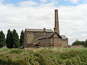
Modern drainage
Steam engine
A steam engine is a heat engine that performs mechanical work using steam as its working fluid.Steam engines are external combustion engines, where the working fluid is separate from the combustion products. Non-combustion heat sources such as solar power, nuclear power or geothermal energy may be...
s, such as Stretham Old Engine
Stretham old engine
Stretham Old Engine is a steam-powered engine just south of Stretham in Cambridgeshire, England, that was used to pump water from flood-affected areas of The Fens back into the River Great Ouse. It is one of only three surviving drainage engines in East Anglia.During the seventeenth century, large...
, which were themselves replaced with diesel-powered pumps and, following World War II
World War II
World War II, or the Second World War , was a global conflict lasting from 1939 to 1945, involving most of the world's nations—including all of the great powers—eventually forming two opposing military alliances: the Allies and the Axis...
, the small electric stations that are still used today.
The dead vegetation of the peat remained undecayed because it was deprived of air (the peat being anaerobic). When it was drained, the oxygen of the air reached it, since when the peat has been slowly oxidizing. This, together with the shrinkage on its initial drying and the removal of soil by the wind, has meant that much of the Fens lies below high tide level
Tide
Tides are the rise and fall of sea levels caused by the combined effects of the gravitational forces exerted by the moon and the sun and the rotation of the Earth....
. As the highest parts of the drained fen are now only a few metres above mean sea level, only sizeable embankments of the rivers, and general flood defences, stop the land from being inundated. Nonetheless, these works are now much more effective than they were. The question of rising sea level under the influence of global warming
Global warming
Global warming refers to the rising average temperature of Earth's atmosphere and oceans and its projected continuation. In the last 100 years, Earth's average surface temperature increased by about with about two thirds of the increase occurring over just the last three decades...
remains.
The Fens today are protected by 60 miles (96.6 km) of embankments defending against the sea and 96 miles (154.5 km) of river embankments. Eleven internal drainage board
Internal Drainage Board
An internal drainage board is a type of operating authority which is established in areas of special drainage need in England and Wales with permissive powers to undertake work to secure clean water drainage and water level management within drainage districts...
(IDB) groups maintain 286 pumping stations and 3800 miles (6,115.5 km) of watercourses, with the combined capacity to pump 16,500 Olympic-size swimming pools in a 24-hour period or to empty Rutland Water
Rutland Water
Rutland Water is Anglian Water's drinking water reservoir in the county of Rutland, England, just east of the county town Oakham. It was known as Empingham Reservoir during its construction and until its official opening in 1976. The centre of its dam is at British national grid reference...
in 3 days.
Modern farming and food manufacturing in the Fens
As of 2008, there are estimated to be 4,000 farms in the Fens involved in agriculture and horticulture, including arable, livestock, poultry, dairy, orchards, vegetables and ornamental plants and flowers. They employ about 27,000 people in full-time and seasonal jobs. In turn, they support around 250 businesses involved in food and drink manufacturing and distribution, employing around 17,500 people.Over 70% of the Fens is involved in environmental stewardship schemes, under which 270 miles (434.5 km) of hedgerow and 1780 miles (2,864.6 km) of ditches are managed, providing large wildlife corridors and habitat for endangered animals such as the water vole.
Restoring the Fens
In 2003, the Great Fen Project was initiated to return parts of the Fens to their original pre-agricultural state. The periodic flooding by the North Sea, which renewed the character of the Fenlands, was characterized conventionally by the 1911 Encyclopædia Britannica as "ravaged by serious inundations of the sea". The modern approach is to allow a little farmland to be flooded again and turned into nature reserveNature reserve
A nature reserve is a protected area of importance for wildlife, flora, fauna or features of geological or other special interest, which is reserved and managed for conservation and to provide special opportunities for study or research...
s. By introducing fresh water, the organizers of the project hope to encourage species such as the snipe
Common Snipe
The Common Snipe is a small, stocky wader native to the Old World. The breeding habitat is marshes, bogs, tundra and wet meadows throughout northern Europe and northern Asia...
, lapwing
Northern Lapwing
The Northern Lapwing , also known as the Peewit, Green Plover or just Lapwing, is a bird in the plover family. It is common through temperate Eurasia....
and bittern. Endangered species such as the fen violet
Fen violet
Viola persicifolia, the fen violet, is a violet , native to central and northern Europe and northern Asia.It grows to a height of 10–30 cm from a creeping rhizome, with narrow, triangular leaves 7–15 mm across...
will be seeded.
The Fens Waterways Link
Fens Waterways Link
The Fens Waterways Link is a project to improve recreational boating opportunities in the counties of Cambridgeshire and Lincolnshire, England. By a combination of improvements to existing waterways and the construction of new links a circular route between Lincoln, Peterborough, Ely and Boston is...
is a scheme to restore navigation to some of the drainage works. It is planned to bring the South Forty-Foot Drain
South Forty-foot drain
The South Forty-Foot Drain is the main channel for the land-drainage of the Black Sluice Level in the Lincolnshire Fens. It lies in eastern England between Guthram Gowt and the Black Sluice pumping station on The Haven, at Boston...
and parts of the Car Dyke into use as part of a route between Boston and Cambridge.
Fen settlements
Many historic cities, towns and villages have grown up in the fens, sited chiefly on the few areas of raised ground. These include:- BourneBourne, LincolnshireBourne is a market town and civil parish on the western edge of the Fens, in the District of South Kesteven in southern Lincolnshire, England.-The town:...
, a market town; - BostonBoston, LincolnshireBoston is a town and small port in Lincolnshire, on the east coast of England. It is the largest town of the wider Borough of Boston local government district and had a total population of 55,750 at the 2001 census...
, port and administrative centre of the Borough of BostonBoston (borough)Boston is a local government district with borough status in Lincolnshire, England. Its council is based in the town of Boston. It lies around N53°0'0" W0°0'0"....
; - Chatteris, a market town;
- CrowlandCrowlandCrowland or Croyland is a small town in south Lincolnshire, England, positioned between Peterborough and Spalding, with two sites of historical interest.-Geography:...
, one of the Fen Five monasteries; also a medieval triangular bridge; - ElyEly, CambridgeshireEly is a cathedral city in Cambridgeshire, England, 14 miles north-northeast of Cambridge and about by road from London. It is built on a Lower Greensand island, which at a maximum elevation of is the highest land in the Fens...
(meaning "Isle of Eels"), whose cathedral – one of the Fen Five monasteries – is known as the "Ship of the Fens"; administrative centre of the East Cambridgeshire District CouncilEast CambridgeshireEast Cambridgeshire is a local government district in Cambridgeshire, England. Its council is based in Ely....
; - Holbeach, a market town;
- LittleportLittleport, CambridgeshireLittleport is the largest village in East Cambridgeshire, England, approximately north of Ely and south-east of Welney. It lies on the Bedford Level South section of the River Great Ouse, close to Burnt Fen and Mare Fen...
, a large village approximately 6 miles (9.7 km) north of Ely; - Little ThetfordLittle ThetfordLittle Thetford is a small village and civil parish south of Ely in Cambridgeshire, England, about by road from London. The village is built on a boulder clay island surrounded by flat fenland countryside, typical of settlements in this part of the East of England...
, settled on a boulder clayBoulder clayBoulder clay, in geology, is a deposit of clay, often full of boulders, which is formed in and beneath glaciers and ice-sheets wherever they are found, but is in a special sense the typical deposit of the Glacial Period in northern Europe and North America...
island within the fens since the Bronze AgeBronze AgeThe Bronze Age is a period characterized by the use of copper and its alloy bronze as the chief hard materials in the manufacture of some implements and weapons. Chronologically, it stands between the Stone Age and Iron Age...
, 3 miles (4.8 km) south of Ely; - Long SuttonLong Sutton, LincolnshireLong Sutton, is a market town in Lincolnshire, England. Located in South Holland district, it lies close to the Wash.-Geography:The town has an estimated population of 5,037 in 2007. It is 13 miles east from Spalding.-Lincolnshire Fens:...
, a market town and home to UK's largest food cannery; - MarchMarch, CambridgeshireMarch is a Fenland market town and civil parish in the Isle of Ely area of Cambridgeshire, England. March was the county town of the Isle of Ely, a separate administrative county between 1889 and 1965, and is now the administrative centre of Fenland District Council.The town was an important...
, a market town and administrative centre of the Fenland DistrictFenlandFenland is a local government district in Cambridgeshire, England. Its council is based in March, and covers the neighbouring market towns of Chatteris, Whittlesey, and Wisbech, often called the "capital of the fens"...
; - Market Deeping, a market town;
- PeterboroughPeterboroughPeterborough is a cathedral city and unitary authority area in the East of England, with an estimated population of in June 2007. For ceremonial purposes it is in the county of Cambridgeshire. Situated north of London, the city stands on the River Nene which flows into the North Sea...
, the largest of the many settlements along the fen edge and sometimes called the "Gateway to the Fens"; its cathedral is one of the Fen Five monasteries; administrative centre of the Peterborough Unitary AuthorityUnitary authorityA unitary authority is a type of local authority that has a single tier and is responsible for all local government functions within its area or performs additional functions which elsewhere in the relevant country are usually performed by national government or a higher level of sub-national...
; - RamseyRamsey, CambridgeshireRamsey is a small Cambridgeshire market town and parish, north of Huntingdon and St Ives. For local government purposes it lies in the district of Huntingdonshire within the local government county of Cambridgeshire....
, a market town; one of the Fen Five monasteries; - SpaldingSpalding, LincolnshireSpalding is a market town with a population of 30,000 on the River Welland in the South Holland district of Lincolnshire, England. Little London is a hamlet directly south of Spalding on the B1172 road....
, a market town, administrative centre of South HollandSouth Holland, LincolnshireSouth Holland is a local government district of Lincolnshire. The district council is based in Spalding.It was formed on 1 April 1974, under the Local Government Act 1972, as a merger of the Spalding urban district with East Elloe Rural District and Spalding Rural District...
, and famed for its annual Flower Parade; - ThorneyThorney, CambridgeshireThorney is a village about 8 miles east of Peterborough in the City of Peterborough unitary authority, England, on the A47. Historically it was part of the Isle of Ely, which was considered part of Cambridgeshire but was transferred into the former county of Huntingdon and Peterborough and...
, one of the Fen Five monasteries; later model village and agricultural estates of the Dukes of Bedford; - WhittleseyWhittleseyWhittlesey, historically known as Whittlesea as the name of the railway station is still spelt, or Witesie, is an ancient Fenland market town around six miles east of Peterborough in the county of Cambridgeshire in England...
, a market town; annual Straw Bear Festival; - WisbechWisbechWisbech is a market town, inland port and civil parish with a population of 20,200 in the Fens of Cambridgeshire. The tidal River Nene runs through the centre of the town and is spanned by two bridges...
("capital of the fens"), a market town.
Ancient sites include:
- Flag FenFlag FenFlag Fen near Peterborough, England is a Bronze Age site, probably religious. It comprises over 60,000 timbers arranged in five very long rows connecting Whittlesey Island with Peterborough across the wet fenland. Part way across the structure, a small island was formed which is where it is...
, a Bronze Age settlement.
Setting in fiction
Some authors have featured the Fens repeatedly in their work. For example:- John GordonJohn Gordon (author)John Gordon is an English writer of adolescent supernatural fiction. He is the author of fifteen fantasy novels , four short story collections, over fifty short stories and a teenage memoir....
, adolescent fiction writer and author of The Giant Under The SnowThe Giant Under The SnowThe Giant Under The Snow is a children's fantasy adventure novel by John Gordon. First published in 1968 the story tells the tale of three school friends who discover an ancient treasure and become embroiled in the final act of an epic battle of good against evil...
, has drawn inspiration for many of his supernatural fantasies from the Fens. His books with Fenland themes include: Ride The Wind, Fen Runners and The House On The Brink, which is based on Peckover House in WisbechWisbechWisbech is a market town, inland port and civil parish with a population of 20,200 in the Fens of Cambridgeshire. The tidal River Nene runs through the centre of the town and is spanned by two bridges...
. - Peter F. HamiltonPeter F. HamiltonPeter F. Hamilton is a British author. He is best known for writing space opera. As of the publication of his tenth novel in 2004, his works had sold over two million copies worldwide.- Biography :...
sets a number of his science fiction novels in the Fens, including Mindstar RisingMindstar RisingMindstar Rising is a science fiction novel by British writer Peter F. Hamilton, published in 1993. It is the first book in the Greg Mandel trilogy. The novel introduces the major characters in the series, most notably Greg and Julia Evans...
and A Quantum MurderA Quantum MurderA Quantum Murder is a novel by Peter F. Hamilton. It is the second book in the Greg Mandel trilogy, between Mindstar Rising and The Nano Flower.-Release details:...
. - Bill Hussey set two horror books, Through a Glass Darkly and The Absence, in the Fens.
- Jim KellyJim Kelly (author)Jim Kelly is an author and journalist. Kelly won the Crime Writers Association Dagger in the Library award in 2006.As of 2011, Kelly has written eight crime novels, including the award-winning The Water Clock, featuring fictional journalist Philip Dryden, based in the Cambridgeshire area of Great...
set both The Water Clock and The Moon Tunnel in the Fens. - Philippa PearcePhilippa PearceAnn Philippa Pearce OBE was an English children's author.-Early life:The youngest of four children, Pearce was brought up in the Mill House in the village of Great Shelford, Cambridgeshire...
, a children's author, set many of her books in the Fens, for example Tom's Midnight GardenTom's Midnight GardenTom's Midnight Garden is a children's novel by Philippa Pearce. It won the Carnegie Medal in 1958, the year of its publication. It has been adapted for radio, television, the cinema, and the stage.-Plot summary:...
. - Gladys MitchellGladys MitchellGladys Mitchell was an English author best known for her creation of Mrs. Bradley, the heroine of numerous detective novels. She also wrote under the pseudonyms Stephen Hockaby and Malcolm Torrie...
, prolific writer of detective fiction, took her eccentric sleuth, the psychiatrist Mrs Lestrange Bradley, to the Fens in several books, notably The Worsted Viper, Wraiths and Changelings and The Mudflats of the Dead.
The following novels, or substantial portions of them, are set in the Fens:
- Sabine Baring-GouldSabine Baring-GouldThe Reverend Sabine Baring-Gould was an English hagiographer, antiquarian, novelist and eclectic scholar. His bibliography consists of more than 1240 publications, though this list continues to grow. His family home, Lew Trenchard Manor near Okehampton, Devon, has been preserved as he had it...
: Cheap Jack Zita; - Penelope FitzgeraldPenelope FitzgeraldPenelope Fitzgerald was a Booker Prize-winning English novelist, poet, essayist and biographer. In 2008, The Times included her in a list of "The 50 greatest British writers since 1945".-Early life:...
: The Bookshop; - Hal Foster: Prince ValiantPrince ValiantPrince Valiant in the Days of King Arthur, or simply Prince Valiant, is a long-run comic strip created by Hal Foster in 1937. It is an epic adventure that has told a continuous story during its entire history, and the full stretch of that story now totals more than 3700 Sunday strips...
; - Martha GrimesMartha GrimesMartha Grimes is an American author of detective fiction.She was born in Pittsburgh, Pennsylvania, to William Dermit Grimes, Pittsburgh's city solicitor, and to June Dunnington, who owned the Mountain Lake Hotel in Western Maryland where Martha and her brother spent much of their childhood. Grimes...
: The Case Has Altered, set in and around AlgarkirkAlgarkirkAlgarkirk is a village and civil parish in the Borough of Boston in Lincolnshire, England, south-south-west of Boston near the A16. Some people spell the village Algakirk. It has a population of 406.-History:...
, Lincolnshire; - Charles KingsleyCharles KingsleyCharles Kingsley was an English priest of the Church of England, university professor, historian and novelist, particularly associated with the West Country and northeast Hampshire.-Life and character:...
: Hereward the Wake; - Louis L'AmourLouis L'AmourLouis Dearborn L'Amour was an American author. His books consisted primarily of Western fiction novels , however he also wrote historical fiction , science fiction , nonfiction , as well as poetry and short-story collections. Many of his stories were made into movies...
: Sackett's Land; - Sile Rice: The Saxon Tapestry, about Hereward the WakeHereward the WakeHereward the Wake , known in his own times as Hereward the Outlaw or Hereward the Exile, was an 11th-century leader of local resistance to the Norman conquest of England....
; - Dorothy Sayers: The Nine TailorsThe Nine TailorsThe Nine Tailors is a 1934 mystery novel by British writer Dorothy L. Sayers, her ninth featuring sleuth Lord Peter Wimsey.- Plot introduction :For this novel, set in the Fens, Sayers had to learn about change ringing...
; - Graham SwiftGraham SwiftGraham Colin Swift FRSL is a British author. He was born in London, England and educated at Dulwich College, London, Queens' College, Cambridge, and later the University of York. He was a friend of Ted Hughes...
: WaterlandWaterland (novel)Waterland is a 1983 novel by Graham Swift. It is considered to be the author's premier novel and was shortlisted for the Booker Prize .In 1992, the book was made into a film version....
(made into a film, listed below); - Robert WestallRobert WestallRobert Atkinson Westall was the author of many books, mostly children's fiction, though also for adults, and non-fiction. Many of his novels, while supposedly aimed at a teenage audience, deal with many complex, dark and in many ways adult themes...
: Futuretrack 5. - Philip PullmanPhilip PullmanPhilip Pullman CBE, FRSL is an English writer from Norwich. He is the best-selling author of several books, most notably his trilogy of fantasy novels, His Dark Materials, and his fictionalised biography of Jesus, The Good Man Jesus and the Scoundrel Christ...
: Northern LightsNorthern Lights (novel)Northern Lights, known as The Golden Compass in North America, is the first novel in English novelist Philip Pullman's His Dark Materials trilogy...
Some films have large portions set in the Fenlands:
- Dad SavageDad SavageDad Savage is a 1998 British film directed by Betsan Morris Evans starring Patrick Stewart as the title character, a tulip plantation owner, quasi-legal entrepreneur and 'cowboy'. Tagged as 'a tale of untamed revenge,' the movie is distinct from, but can be considered similar to, Guy Ritchie's...
(1998), starring Patrick StewartPatrick StewartSir Patrick Hewes Stewart, OBE is an English film, television and stage actor, who has had a distinguished career in theatre and television for around half a century...
, was set and filmed around the King's LynnKing's LynnKing's Lynn is a sea port and market town in the ceremonial county of Norfolk in the East of England. It is situated north of London and west of Norwich. The population of the town is 42,800....
area. - WaterlandWaterland (film)Waterland is a 1992 film directed by Stephen Gyllenhaal, based on the 1983 novel of the same name by Graham Swift. The film starred Jeremy Irons, Sinéad Cusack, Ethan Hawke, and John Heard.-Plot:...
(1992), directed by Stephen GyllenhaalStephen Gyllenhaal-Personal life:Gyllenhaal was born in Cleveland, Ohio, the son of Virginia Lowrie and Hugh Anders Gyllenhaal. The Gyllenhaal family is a descendant of the cavalry officer Nils Gunnesson Haal, who was ennobled in 1652 when Queen Christina of Sweden conferred upon him the crest and family name,...
, is based on Graham Swift's book with the same title. Many of its scenes were filmed at Holbeach Marsh on the edge of the Wash.
At least one video game has also been set in the Fens:
- "The Bedford Level" appears in the video game Tom Clancy's EndWarTom Clancy's EndWarTom Clancy's EndWar is a real-time tactics game designed by Ubisoft Shanghai for the PlayStation 3, Xbox 360 and Windows platforms. The Nintendo DS and PlayStation Portable versions feature turn-based tactics instead of the real-time tactics of their console counterparts...
as a possible battlefield.
See also
- Fen skatingFen skatingFen skating is a traditional form of ice skating in the Fenland of England. The Fens of East Anglia, with their easily flooded meadows, form an ideal skating terrain. Skates were introduced into Britain from Holland or France in the seventeenth century...
, a sport for which the Fens are famous - Gilbert Heathcote's tunnelGilbert Heathcote's tunnelGilbert Heathcote's tunnel was an engineering project dating from the 1630s as one of the earliest modern attempts to drain The Fens in Lincolnshire...
, a drainage project in the 1630s - Hereward the WakeHereward the WakeHereward the Wake , known in his own times as Hereward the Outlaw or Hereward the Exile, was an 11th-century leader of local resistance to the Norman conquest of England....
, who led Saxon resistance to the Norman Conquest from the fens - High FensHigh FensThe High Fens , which were declared a nature reserve in 1957, are an upland area, a plateau region in the province of Liège, in the east of Belgium and nearby parts of Germany, lying between the Ardennes and the Eifel highlands. It is the largest nature reserve or park in Belgium, with an area of ;...
, between BelgiumBelgiumBelgium , officially the Kingdom of Belgium, is a federal state in Western Europe. It is a founding member of the European Union and hosts the EU's headquarters, and those of several other major international organisations such as NATO.Belgium is also a member of, or affiliated to, many...
and Germany - Pinchbeck EnginePinchbeck EngineThe Pinchbeck Engine is a drainage engine, a rotative beam engine built in 1833 to drain Pinchbeck Marsh, to the north of Spalding, Lincolnshire, in England...
, a museum of fen drainage based around the longest-working beam engine and scoopwheel - Somerset LevelsSomerset LevelsThe Somerset Levels, or the Somerset Levels and Moors as they are less commonly but more correctly known, is a sparsely populated coastal plain and wetland area of central Somerset, South West England, between the Quantock and Mendip Hills...
, a similar area of wetlands in the southwest of England - Wicken FenWicken FenWicken Fen is a wetland nature reserve situated near the village of Wicken, Cambridgeshire, England.It is one of Britain's oldest nature reserves, and was the first reserve acquired by the National Trust, in 1899. The reserve includes fenland, farmland, marsh, and reedbeds...
, one of the few remaining undrained fens, owned by the National TrustNational Trust for Places of Historic Interest or Natural BeautyThe National Trust for Places of Historic Interest or Natural Beauty, usually known as the National Trust, is a conservation organisation in England, Wales and Northern Ireland...
Further reading
archived online: Volume 1, Volume 2Drainage boards
- Ely Internal Drainage Board
- Middle Level Commissioners
- North Level District Internal Drainage Board
- Black Sluice Internal Drainage Board
- Witham First District Internal Drainage Board
- Witham Third District Internal Drainage Board
- Witham Fourth District Internal Drainage Board
Other
- Flag Fen Archaeology Trust official website
- The Great Fen Project official website
- Thorney Heritage Museum official website
- Wicken Fen National Nature Reserve (National Trust educational site)
- Geograph covering map of the Fens (clickable map linking to photo galleries)
- "Powte's Complaint" (17th century protest song about Fen drainage, at Literary Norfolk)