
Yorkshire Wolds
Encyclopedia
The Yorkshire Wolds are low hills in the counties of East Riding of Yorkshire
and North Yorkshire
in northeastern England. The name also applies to the district in which the hills lie.
On the western edge the Wolds rise to an escarpment
which then drops sharply to the Vale of York
. The highest point on the escarpment is Bishop Wilton Wold
(also known as Garrowby Hill), which is 246 metres (807 feet) above sea level
. To the north, on the other side of the Vale of Pickering
, lie the North York Moors, and to the east the hills flatten into the plain of Holderness
.
The largest town in the Wolds is Driffield
, with other places including Pocklington
, Thixendale
and Kilham
, the original capital of the Wolds.
, and make an arc from the Humber
estuary west of Kingston upon Hull
up to the North Sea
coast between Bridlington
and Scarborough. Here they rise up to form cliff
s, most notably at Flamborough
, Bempton Cliffs and Filey
; Flamborough Headland is designated a Heritage Coast
. On the other side of the Humber, the chalk formations continue as the Lincolnshire Wolds
; in fact, one can view the Humber as cutting through a single formation. The Humber Bridge
was built at the point due to its geological stability.
Most of the area takes the form of an elevated, gently rolling plateau, cut by numerous deep, steep-sided, flat-bottomed valleys of glacial origin. The chalk formation of the hills provides exceptionally good drainage, with the result that most of these valleys are dry; indeed, surface water is quite scarce throughout the Wolds. Typically the valleys are hard to see from above, creating the visual impression that the landscape is much flatter than is actually the case. The unusual topography results in an "upside-down" farming system - livestock (mostly sheep and cows) graze the valleys, with the hills above used for crops.
 The Wolds reach the sea at Flamborough Head
where the chalk cliffs plunge over 130 metres (426.5 ft) to the North Sea. To the south of Flamborough
lies the resort town of Bridlington
and to the north the sheer cliffs at Speeton
overlook Filey
Bay. Inland the high Wolds scarp overlooks the Vale of Pickering
.
The so called Great Wold Valley
traverses the area. It is occupied by a small stream called the Gypsey Race
. This stream empties its waters into Bridlington harbour. The valley of the Gypsey Race
turns south and then east in two right angle bends, one at Burton Fleming
, the other at Rudston
. In dry conditions the stream frequently dries up in parts of its course and re-emerges downstream.
Another notable feature of this area of the Wolds is Danes Dyke, a great ditch extending across Flamborough Head. The dyke consists of double ramparts, a ditch which is about sixty feet wide and twenty feet deep and a further rampart which rises to eighteen feet above ground level. The origin of this feature is obscure although it is certainly not Danish.
Bempton Cliffs is a seabird colony and an R.S.P.B. nature reserve.
apr2006.jpg) Notable settlements include Flamborough village, North Landing and South Landing on Flamborough Headland. The village of Reighton
Notable settlements include Flamborough village, North Landing and South Landing on Flamborough Headland. The village of Reighton
which extends down the steep scarp face of the Wolds has many buildings made of the local chalk. Hunmanby
was once a large market town and its buildings are centered on the old triangular market place.
A series of villages lies at the foot of the northern scarp of the Wolds each having a parish which contains an area of chalk hillside, fertile benches and marshy land on the Vale of Pickering.
Fordon is one of the smallest villages in England consisting of only a few farms and a small church some parts of which are of Norman construction. Wold Newton and Burton Fleming lie in the Great Wold Valley. A gigantic round barrow called Willy Howe lies between Wold Newton and Thwing and at Rudston
Howe
, a topographic name from Middle English
, originated with the Old Norse
word haugr meaning a small hill or a man-made mound or barrow. Britain's tallest standing stone can be seen in the church yard. Boynton Hall was the home of William Strickland who is reputed to have brought turkey to England.
On the Wold top there are many traces of pre-historic peoples such as the barrows at Willerby Wold and Sharpe Howes above Folkton.
. Driffield
lies central to the crescentic shape of the Wolds area and since all of the Wolds are within easy reach it has become an important market town and is known as the Capital of the Wolds.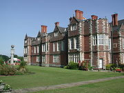 Villages of note include: Nafferton
, which lies just off the A166 road and boasts a pretty mill pond fed by springs, Wansford
to the south, lies on the Driffield canal and it has a church built by Sir Tatton Sykes
in 1868. Close to Ruston Parva
is Danes Graves, an archaeological site consisting of some 500 small round barrows marking Iron Age burials at least one of which yielded a corpse buried with a chariot and harness. Burton Agnes
boasts the ruins of a manor house dating from 1170 AD and a fine Hall and gatehouse of the Elizabethan period. Kilham
was a prosperous market town in the Medieval period but was replaced by Driffield in the 19th century as the Capital of the Wolds. In this area there is a long continuity of settlement with an Iron Age cemetery, two Roman roads and an Anglian cemetery all in close proximity. Sledmere
village has a uniformity of aspect which reveals its history as an 'estate' village. Close by is Sledmere House
, the home of the Sykes family
since the 18th century.
 In the south the Wolds are at their narrowest. Here they lie between the plain of Holderness
to the east and the Vale of York
to the west. The Humber Estuary cuts through the chalk formation leaving the Yorkshire Wolds to the north and the Lincolnshire Wolds
to the south. In Roman times the estuary was crossed by a ford. The Humber Bridge
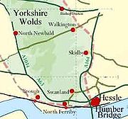
now spans the estuary. This area has fine agricultural land and many attractive villages, notable amongst which are: Walkington
with its village pond and church of All Hallows: Bishop Burton
which lies in a green hollow and has 19th century whitewashed cottages close to a village green with a large pond: Cherry Burton
sits in a shallow valley in the shadow of the beautiful St Michael's and All Angels Church: Skidby
which has an intact working windmill dating from 1821 which is now an agricultural museum. North Newbald
is sited in a narrow valley on the western scarp of the Wolds and has a famous cruciform Norman church dedicated to St Nicholas.
and Market Weighton
are sited between the wolds and the vale. Large parks and houses lie along the scarp from Garrowby Hall to Kilnwick Percy, Warter Priory and Londesborough Hall. Millington
has a beautiful situation within Millington Dale and the road leading along the brow of the dale is particularly scenic. The village of Kiplingcotes
is the location for the annual Kiplingcotes Derby
horse race, said to be the oldest horse race in England. The 490th event took place on 19 March 2009.
 From Garrowby Hill northwards to Ganton the high scarp of the Wolds swings in a crescent to overlook the Vales of York and Pickering. Villages tend to be clustered along the scarp foot or in the upper part of the Great Wold Valley. Rillington
is an attractive village with a stream passing through and a nearby park at Scampston. At Knapton
village there is a hall and park and above the village in Knapton Plantation is Staple Howe, an Iron Age
site. The twin villages of East and West Heslerton
lie further along the A64 road.West Heslerton is a well known archaeological site, with artefacts from several eras having been recovered. Wharram Percy
is one of the most notable deserted village sites in the U.K.
The availability of fertile chalk soils, good grazing and the light tree cover along with stone suitable for making tools made this area attractive to early Neolithic settlers.
Along with Wessex and Orkney, the Yorkshire Wolds is a key area for studying the development of the Neolithic
period in the British Isles as it became a major focus for settlement in this era. Isolated farms rather than settlements of any size appear to have been the normal dwelling types however few have been located with any certainty and most evidence is of funerary sites and ritual monuments. Recently excavated long barrows at Fordon
on Willerby Wold and at Kilham have been carbon dated
to around 3700 B.C. A well-known round barrow of this period is the monumental Duggleby Howe
, at the western end of the Great Wolds Valley, partially excavated in 1890 by J.R. Mortimer. A henge monument of the Neolithic has been identified at Maidens Grave Rudston and the Rudston Monolith has also been assigned to this period. An extensive Neolithic ritual complex, the main elements of which are four large cursus
monuments and a henge, is situated near the eastern end of the Great Wold Valley
.
More than 1,400 Bronze Age
round barrows, comprising one or more burials and accompanied by items of grave goods, are known to exist on the Yorkshire Wolds. They occur either in isolation or, more commonly, grouped together to form cemeteries. Many of these sites, although they have been reduced in size by repeated ploughing, still form upstanding and, in some cases, prominent features in the present-day landscape.
The Romans arrived in this area around A.D.71. From a base at Brough
on the north bank of the Humber they established a road network with one branch towards York
and another to Malton
, both crossing the Wolds area. The settlements of the native Parisii were little disturbed by the Roman occupiers at first, but in later years they became Romanised, adopting the Roman material culture. There are villa sites on the Wolds at Rudston, Harpham, Brantingham, Welton and Wharram-le-Street.
Walkington Wold, near the village of Walkington
in the southern area of the Wolds, is the site of an Anglo-Saxon execution cemetery, the only known example from northern England.
who was born at Rudston
lived in the area and described the Wolds as "fold upon fold of the encircling hills, piled rich and golden."
The Yorkshire Wolds were a subject of BBC TV's Inside Out (North) programme on 2 February 2007.
The Yorkshire Wolds Versatile Brass entertains local communities in local venues in the Yorkshire Wolds region.
is a long-distance footpath which runs the length of the wolds from the Humber Bridge
at Hessle
to Filey
on the coast. It is managed by the Countryside Commission
.
East Riding of Yorkshire
The East Riding of Yorkshire, or simply East Yorkshire, is a local government district with unitary authority status, and a ceremonial county of England. For ceremonial purposes the county also includes the city of Kingston upon Hull, which is a separate unitary authority...
and North Yorkshire
North Yorkshire
North Yorkshire is a non-metropolitan or shire county located in the Yorkshire and the Humber region of England, and a ceremonial county primarily in that region but partly in North East England. Created in 1974 by the Local Government Act 1972 it covers an area of , making it the largest...
in northeastern England. The name also applies to the district in which the hills lie.
On the western edge the Wolds rise to an escarpment
Escarpment
An escarpment is a steep slope or long cliff that occurs from erosion or faulting and separates two relatively level areas of differing elevations.-Description and variants:...
which then drops sharply to the Vale of York
Vale of York
The Vale of York is an area of flat land in the north-east of England. The vale is a major agricultural area and serves as the main north-south transport corridor for northern England....
. The highest point on the escarpment is Bishop Wilton Wold
Bishop Wilton Wold
Bishop Wilton Wold is the highest point of the Yorkshire Wolds in the East Riding of Yorkshire, England. The summit, known as Garrowby Hill, lies about 5 miles north of Pocklington....
(also known as Garrowby Hill), which is 246 metres (807 feet) above sea level
Sea level
Mean sea level is a measure of the average height of the ocean's surface ; used as a standard in reckoning land elevation...
. To the north, on the other side of the Vale of Pickering
Vale of Pickering
The Vale of Pickering is a low-lying flat area of land in North Yorkshire, England. It is drained by the River Derwent. The landscape is rural with scattered villages and small market towns. It has been inhabited continuously from the Mesolithic period...
, lie the North York Moors, and to the east the hills flatten into the plain of Holderness
Holderness
Holderness is an area of the East Riding of Yorkshire, on the east coast of England. An area of rich agricultural land, Holderness was marshland until it was drained in the Middle Ages. Topographically, Holderness has more in common with the Netherlands than other parts of Yorkshire...
.
The largest town in the Wolds is Driffield
Driffield
Driffield, also known as Great Driffield, is a market town and civil parish in the East Riding of Yorkshire, England. The civil parish is formed by the town of Driffield and the village of Little Driffield....
, with other places including Pocklington
Pocklington
Pocklington is a small market town and civil parish situated at the foot of the Yorkshire Wolds in the East Riding of Yorkshire, England, approximately east of York....
, Thixendale
Thixendale
Thixendale is a tiny village and civil parish in the Ryedale district of North Yorkshire, England. It is located in the Yorkshire Wolds, about 20 miles east of York.The population of the village and surrounding farms is 130....
and Kilham
Kilham, East Riding of Yorkshire
Kilham is a village and civil parish in the East Riding of Yorkshire, England. It is situated about north-east of Driffield town centre.According to the 2001 UK census, Kilham parish had a population of 1,010....
, the original capital of the Wolds.
Geology and Natural History
The hills are formed from chalkChalk
Chalk is a soft, white, porous sedimentary rock, a form of limestone composed of the mineral calcite. Calcite is calcium carbonate or CaCO3. It forms under reasonably deep marine conditions from the gradual accumulation of minute calcite plates shed from micro-organisms called coccolithophores....
, and make an arc from the Humber
Humber
The Humber is a large tidal estuary on the east coast of Northern England. It is formed at Trent Falls, Faxfleet, by the confluence of the tidal River Ouse and the tidal River Trent. From here to the North Sea, it forms part of the boundary between the East Riding of Yorkshire on the north bank...
estuary west of Kingston upon Hull
Kingston upon Hull
Kingston upon Hull , usually referred to as Hull, is a city and unitary authority area in the ceremonial county of the East Riding of Yorkshire, England. It stands on the River Hull at its junction with the Humber estuary, 25 miles inland from the North Sea. Hull has a resident population of...
up to the North Sea
North Sea
In the southwest, beyond the Straits of Dover, the North Sea becomes the English Channel connecting to the Atlantic Ocean. In the east, it connects to the Baltic Sea via the Skagerrak and Kattegat, narrow straits that separate Denmark from Norway and Sweden respectively...
coast between Bridlington
Bridlington
Bridlington is a seaside resort, minor sea fishing port and civil parish on the Holderness Coast of the North Sea, in the East Riding of Yorkshire, England. It has a static population of over 33,000, which rises considerably during the tourist season...
and Scarborough. Here they rise up to form cliff
Cliff
In geography and geology, a cliff is a significant vertical, or near vertical, rock exposure. Cliffs are formed as erosion landforms due to the processes of erosion and weathering that produce them. Cliffs are common on coasts, in mountainous areas, escarpments and along rivers. Cliffs are usually...
s, most notably at Flamborough
Flamborough Head
Flamborough Head is a promontory of on the Yorkshire coast of England, between the Filey and Bridlington bays of the North Sea. It is a chalk headland, and the resistance it offers to coastal erosion may be contrasted with the low coast of Holderness to the south...
, Bempton Cliffs and Filey
Filey
Filey is a small town and civil parish in North Yorkshire, England. It forms part of the borough of Scarborough and is located between Scarborough and Bridlington on the North Sea coast. Although it started out as a fishing village, it has a large beach and is a popular tourist resort...
; Flamborough Headland is designated a Heritage Coast
Heritage Coast
A Heritage Coast is a strip of UK coastline designated by the Countryside Agency in England and the Countryside Council for Wales as having notable natural beauty or scientific significance.- Designated coastline :...
. On the other side of the Humber, the chalk formations continue as the Lincolnshire Wolds
Lincolnshire Wolds
The Lincolnshire Wolds is a range of hills in the county of Lincolnshire, England. It is a designated Area of Outstanding Natural Beauty , and the highest area of land in eastern England between Yorkshire and Kent...
; in fact, one can view the Humber as cutting through a single formation. The Humber Bridge
Humber Bridge
The Humber Bridge, near Kingston upon Hull, England, is a 2,220 m single-span suspension bridge, which opened to traffic on 24 June 1981. It is the fifth-largest of its type in the world...
was built at the point due to its geological stability.
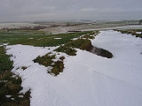
Most of the area takes the form of an elevated, gently rolling plateau, cut by numerous deep, steep-sided, flat-bottomed valleys of glacial origin. The chalk formation of the hills provides exceptionally good drainage, with the result that most of these valleys are dry; indeed, surface water is quite scarce throughout the Wolds. Typically the valleys are hard to see from above, creating the visual impression that the landscape is much flatter than is actually the case. The unusual topography results in an "upside-down" farming system - livestock (mostly sheep and cows) graze the valleys, with the hills above used for crops.
Climate
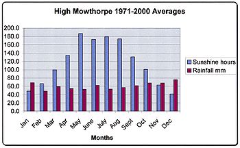
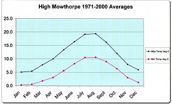
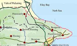
Located in the northern part of the UK, the Yorkshire Wolds have a temperate maritime climate which is dominated by the passage of mid latitude depressions. The weather is very changeable from day to day and the warming influence of the Gulf Stream makes the region mild for its latitude. The higher ground of the Wolds results in their being slightly cooler than the surrounding lowland areas and drifting snow is a problem in winter.The average total annual rainfall is 729mm with rain falling on 128 days of the year. January is usually the coldest month and December the wettest.The warmest month is August and the driest is February.The Northern Wolds and Flamborough Head
Flamborough Head
Flamborough Head is a promontory of on the Yorkshire coast of England, between the Filey and Bridlington bays of the North Sea. It is a chalk headland, and the resistance it offers to coastal erosion may be contrasted with the low coast of Holderness to the south...
where the chalk cliffs plunge over 130 metres (426.5 ft) to the North Sea. To the south of Flamborough
Flamborough
Flamborough is a village and civil parish in the East Riding of Yorkshire, England. It is situated approximately north east of Bridlington town centre on the prominent coastal feature of Flamborough Head. The most prominent man-made feature of the area is Flamborough lighthouse. The headland...
lies the resort town of Bridlington
Bridlington
Bridlington is a seaside resort, minor sea fishing port and civil parish on the Holderness Coast of the North Sea, in the East Riding of Yorkshire, England. It has a static population of over 33,000, which rises considerably during the tourist season...
and to the north the sheer cliffs at Speeton
Speeton
Speeton is a village in the civil parish of Reighton, in North Yorkshire, England. It lies near the edge of the coastal cliffs midway between Filey and Bridlington....
overlook Filey
Filey
Filey is a small town and civil parish in North Yorkshire, England. It forms part of the borough of Scarborough and is located between Scarborough and Bridlington on the North Sea coast. Although it started out as a fishing village, it has a large beach and is a popular tourist resort...
Bay. Inland the high Wolds scarp overlooks the Vale of Pickering
Vale of Pickering
The Vale of Pickering is a low-lying flat area of land in North Yorkshire, England. It is drained by the River Derwent. The landscape is rural with scattered villages and small market towns. It has been inhabited continuously from the Mesolithic period...
.
The so called Great Wold Valley
Great Wold Valley
The Great Wold Valley is the largest and broadest of the valleys cutting into the Yorkshire Wolds. It carries the Gypsey Race, an intermittent stream, which once ran from Wharram-le-Street eastwards along and through the northern Yorkshire Wolds to reach the sea at Bridlington.It is known that the...
traverses the area. It is occupied by a small stream called the Gypsey Race
Gypsey Race
The Gypsey Race is a stream that runs through the villages of West Lutton, East Lutton, Helperthorpe, Weaverthorpe, Butterwick, Foxholes, Wold Newton, Burton Fleming, Rudston and Boynton. The stream flows into the North Sea in Bridlington harbour....
. This stream empties its waters into Bridlington harbour. The valley of the Gypsey Race
Gypsey Race
The Gypsey Race is a stream that runs through the villages of West Lutton, East Lutton, Helperthorpe, Weaverthorpe, Butterwick, Foxholes, Wold Newton, Burton Fleming, Rudston and Boynton. The stream flows into the North Sea in Bridlington harbour....
turns south and then east in two right angle bends, one at Burton Fleming
Burton Fleming
Burton Fleming is a village and civil parish in the East Riding of Yorkshire, England. It lies close to the border with North Yorkshire. The village is situated approximately north west of Bridlington and south of Filey in North Yorkshire....
, the other at Rudston
Rudston
Rudston is a small village and civil parish in the East Riding of Yorkshire, England. It is situated between Driffield and Bridlington approximately to the west of Bridlington, and lies on the B1253 road....
. In dry conditions the stream frequently dries up in parts of its course and re-emerges downstream.
Another notable feature of this area of the Wolds is Danes Dyke, a great ditch extending across Flamborough Head. The dyke consists of double ramparts, a ditch which is about sixty feet wide and twenty feet deep and a further rampart which rises to eighteen feet above ground level. The origin of this feature is obscure although it is certainly not Danish.
Bempton Cliffs is a seabird colony and an R.S.P.B. nature reserve.
Reighton
Reighton is a village and civil parish, in the Scarborough district of North Yorkshire, England.According to the 2001 UK census, Reighton parish had a population of 387....
which extends down the steep scarp face of the Wolds has many buildings made of the local chalk. Hunmanby
Hunmanby
Hunmanby is a large village , which was classified as a town until the 1960s, and civil parish in the Scarborough district of North Yorkshire, England...
was once a large market town and its buildings are centered on the old triangular market place.
A series of villages lies at the foot of the northern scarp of the Wolds each having a parish which contains an area of chalk hillside, fertile benches and marshy land on the Vale of Pickering.
Fordon is one of the smallest villages in England consisting of only a few farms and a small church some parts of which are of Norman construction. Wold Newton and Burton Fleming lie in the Great Wold Valley. A gigantic round barrow called Willy Howe lies between Wold Newton and Thwing and at Rudston
Rudston
Rudston is a small village and civil parish in the East Riding of Yorkshire, England. It is situated between Driffield and Bridlington approximately to the west of Bridlington, and lies on the B1253 road....
Howe
Howe
Howe from the meaning hill, knoll, or mound may refer to:*a tumulus , in particular a Bowl barrow.Places in the United Kingdom:*Howe, North Yorkshire*Howe, Norfolk*Maeshowe, Orkney*Duggleby Howe, East Yorkshire...
, a topographic name from Middle English
Middle English
Middle English is the stage in the history of the English language during the High and Late Middle Ages, or roughly during the four centuries between the late 11th and the late 15th century....
, originated with the Old Norse
Old Norse
Old Norse is a North Germanic language that was spoken by inhabitants of Scandinavia and inhabitants of their overseas settlements during the Viking Age, until about 1300....
word haugr meaning a small hill or a man-made mound or barrow. Britain's tallest standing stone can be seen in the church yard. Boynton Hall was the home of William Strickland who is reputed to have brought turkey to England.
On the Wold top there are many traces of pre-historic peoples such as the barrows at Willerby Wold and Sharpe Howes above Folkton.
The Capital Wolds
On the seaward dip slope of the Wolds there is a series of villages extending from Bridlington to Driffield. These mark the spring line and the natural boundary between the chalk Wolds and the clay of HoldernessHolderness
Holderness is an area of the East Riding of Yorkshire, on the east coast of England. An area of rich agricultural land, Holderness was marshland until it was drained in the Middle Ages. Topographically, Holderness has more in common with the Netherlands than other parts of Yorkshire...
. Driffield
Driffield
Driffield, also known as Great Driffield, is a market town and civil parish in the East Riding of Yorkshire, England. The civil parish is formed by the town of Driffield and the village of Little Driffield....
lies central to the crescentic shape of the Wolds area and since all of the Wolds are within easy reach it has become an important market town and is known as the Capital of the Wolds.
Nafferton
Nafferton is a village and civil parish in the East Riding of Yorkshire, England. It is situated approximately north east of Driffield town centre and lies just south of the A614 road....
, which lies just off the A166 road and boasts a pretty mill pond fed by springs, Wansford
Wansford, East Riding of Yorkshire
Wansford is a village in the East Riding of Yorkshire, England, it forms part of the civil parish of Skerne and Wansford. It is situated on the B1249 road and just to the north of the River Hull and the Driffield Canal. It is approximately south east of Driffield and north west of North...
to the south, lies on the Driffield canal and it has a church built by Sir Tatton Sykes
Sykes
Sykes is a British sitcom that aired on BBC1 from 1972 to 1979. Starring Eric Sykes and Hattie Jacques, it was written by Eric Sykes, who had previously starred with Jacques in Sykes and A... and Sykes and a Big, Big Show ....
in 1868. Close to Ruston Parva
Ruston Parva
Ruston Parva is a hamlet in the East Riding of Yorkshire, England. It is situated approximately south west of Bridlington and lies just north of the A614 road.It forms part of the civil parish of Harpham....
is Danes Graves, an archaeological site consisting of some 500 small round barrows marking Iron Age burials at least one of which yielded a corpse buried with a chariot and harness. Burton Agnes
Burton Agnes
Burton Agnes is a village and civil parish in the East Riding of Yorkshire, England. It is situated on the A614 mid way between Driffield and Bridlington. Places of interest include an Elizabethan Manor House, Burton Agnes Hall and a Norman Manor House, Burton Agnes Manor House...
boasts the ruins of a manor house dating from 1170 AD and a fine Hall and gatehouse of the Elizabethan period. Kilham
Kilham, East Riding of Yorkshire
Kilham is a village and civil parish in the East Riding of Yorkshire, England. It is situated about north-east of Driffield town centre.According to the 2001 UK census, Kilham parish had a population of 1,010....
was a prosperous market town in the Medieval period but was replaced by Driffield in the 19th century as the Capital of the Wolds. In this area there is a long continuity of settlement with an Iron Age cemetery, two Roman roads and an Anglian cemetery all in close proximity. Sledmere
Sledmere
Sledmere is a village in the East Riding of Yorkshire, England that is situated approximately north west of Driffield on the B1253 road.Together with the hamlet of Croome it forms the civil parish of Sledmere and Croome....
village has a uniformity of aspect which reveals its history as an 'estate' village. Close by is Sledmere House
Sledmere House
Sledmere House is a Grade I listed Georgian country house, containing Chippendale, Sheraton and French furnishings and many fine pictures, set within a park designed by Capability Brown. It is located in the village of Sledmere, between Driffield and Malton, in the East Riding of Yorkshire, England...
, the home of the Sykes family
Sykes family of Sledmere
The Sykes family of Sledmere own Sledmere House in Yorkshire, England.-Family history:The Sykes family settled in Sykes Dyke near Carlisle in Cumberland during the Middle Ages. The earliest correspondence in the Sykes archives relates to Richard Sykes , from his factors in Danzig and local gentry...
since the 18th century.
The Southern Wolds
Holderness
Holderness is an area of the East Riding of Yorkshire, on the east coast of England. An area of rich agricultural land, Holderness was marshland until it was drained in the Middle Ages. Topographically, Holderness has more in common with the Netherlands than other parts of Yorkshire...
to the east and the Vale of York
Vale of York
The Vale of York is an area of flat land in the north-east of England. The vale is a major agricultural area and serves as the main north-south transport corridor for northern England....
to the west. The Humber Estuary cuts through the chalk formation leaving the Yorkshire Wolds to the north and the Lincolnshire Wolds
Lincolnshire Wolds
The Lincolnshire Wolds is a range of hills in the county of Lincolnshire, England. It is a designated Area of Outstanding Natural Beauty , and the highest area of land in eastern England between Yorkshire and Kent...
to the south. In Roman times the estuary was crossed by a ford. The Humber Bridge
Humber Bridge
The Humber Bridge, near Kingston upon Hull, England, is a 2,220 m single-span suspension bridge, which opened to traffic on 24 June 1981. It is the fifth-largest of its type in the world...
now spans the estuary. This area has fine agricultural land and many attractive villages, notable amongst which are: Walkington
Walkington
Walkington is a village and civil parish in the East Riding of Yorkshire, England. It is situated approximately to the south west of the town of Beverley on the B1230 road.The civil parish is formed by the village of Walkington and the hamlet of Broadgate...
with its village pond and church of All Hallows: Bishop Burton
Bishop Burton
Bishop Burton is a village and civil parish in the East Riding of Yorkshire, England. It lies on the A1079 road approximately to the west of the market town of Beverley.According to the 2001 UK census, Bishop Burton parish had a population of 628....
which lies in a green hollow and has 19th century whitewashed cottages close to a village green with a large pond: Cherry Burton
Cherry Burton
Cherry Burton is a village and civil parish in the East Riding of Yorkshire, England. It is situated approximately north west of the market town of Beverley and lies to the west of the B1248 road....
sits in a shallow valley in the shadow of the beautiful St Michael's and All Angels Church: Skidby
Skidby
Skidby is a small village and civil parish in the East Riding of Yorkshire, England. It is situated approximately north west of Hull city centre and south of Beverley. It lies just to the west of the A164 road which makes it very accessible....
which has an intact working windmill dating from 1821 which is now an agricultural museum. North Newbald
North Newbald
North Newbald is a village in the East Riding of Yorkshire, England.North Newbald along with the hamlet of South Newbald forms the civil parish of Newbald....
is sited in a narrow valley on the western scarp of the Wolds and has a famous cruciform Norman church dedicated to St Nicholas.
Central Wolds
The western scarp of the Wolds reaches is highest point at Garrowby Hill. It is well dissected and attractive wooded dales occur along the scarp with small becks flowing down to the Vale of York below. The market towns of PocklingtonPocklington
Pocklington is a small market town and civil parish situated at the foot of the Yorkshire Wolds in the East Riding of Yorkshire, England, approximately east of York....
and Market Weighton
Market Weighton
Market Weighton is a small town and civil parish in the East Riding of Yorkshire, England. It is one of the main market towns in the East Yorkshire Wolds and lies midway between Hull and York, about from either one...
are sited between the wolds and the vale. Large parks and houses lie along the scarp from Garrowby Hall to Kilnwick Percy, Warter Priory and Londesborough Hall. Millington
Millington, East Riding of Yorkshire
Millington is a small village and civil parish in the East Riding of Yorkshire, England. It is situated approximately north east of Pocklington.The civil parish is formed by the village of Millington and the hamlets of Great Givendale and Ousethorpe....
has a beautiful situation within Millington Dale and the road leading along the brow of the dale is particularly scenic. The village of Kiplingcotes
Kiplingcotes
Kiplingcotes is a hamlet in the East Riding of Yorkshire, England. It is situated approximately north east of the market town of Market Weighton. to the east lies Etton.It is split between the civil parishes of Dalton Holme and Etton....
is the location for the annual Kiplingcotes Derby
Kiplingcotes Derby
Kiplingcotes Derby is widely accepted to be the oldest annual horse race in the English sporting calendar.It reputedly began in 1519 and takes place on the third Thursday in March, often in exceptionally adverse weather conditions...
horse race, said to be the oldest horse race in England. The 490th event took place on 19 March 2009.
The Western Wolds
Rillington
Rillington is a village and civil parish in the Ryedale district of North Yorkshire, England.-Transport:Rillington is on the A64 road, approximately 3 miles east of Malton and south-west of Scarborough....
is an attractive village with a stream passing through and a nearby park at Scampston. At Knapton
Knapton
Knapton is a village and a civil parish in the English county of Norfolk. The village is south-east of Cromer, north-east of Norwich and north-east of London. The village lies north-east of the A149 between Kings Lynn and Great Yarmouth. The nearest railway station is at North Walsham for the...
village there is a hall and park and above the village in Knapton Plantation is Staple Howe, an Iron Age
Iron Age
The Iron Age is the archaeological period generally occurring after the Bronze Age, marked by the prevalent use of iron. The early period of the age is characterized by the widespread use of iron or steel. The adoption of such material coincided with other changes in society, including differing...
site. The twin villages of East and West Heslerton
West Heslerton
West Heslerton is a small village in North Yorkshire, England, located 10 kilometres southeast of Pickering.The village is the site of one of Britain's largest archaeological excavations, that of a large settlement which seems to have been occupied for several centuries until about 800 AD...
lie further along the A64 road.West Heslerton is a well known archaeological site, with artefacts from several eras having been recovered. Wharram Percy
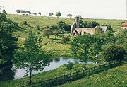
Wharram Percy
Wharram Percy is a deserted medieval village site on the western edge of the chalk Wolds in North Yorkshire, England. The site is about one mile south of Wharram-le-Street and is clearly signposted from the B1248 Beverley to Malton road...
is one of the most notable deserted village sites in the U.K.
History and archaeology
The Wolds area is rich in archaeological remains. There is a profusion of Neolithic, Bronze Age and Romano-British sites extending across the entire Yorkshire Wolds area.The availability of fertile chalk soils, good grazing and the light tree cover along with stone suitable for making tools made this area attractive to early Neolithic settlers.
Along with Wessex and Orkney, the Yorkshire Wolds is a key area for studying the development of the Neolithic
Neolithic
The Neolithic Age, Era, or Period, or New Stone Age, was a period in the development of human technology, beginning about 9500 BC in some parts of the Middle East, and later in other parts of the world. It is traditionally considered as the last part of the Stone Age...
period in the British Isles as it became a major focus for settlement in this era. Isolated farms rather than settlements of any size appear to have been the normal dwelling types however few have been located with any certainty and most evidence is of funerary sites and ritual monuments. Recently excavated long barrows at Fordon
Fordon, East Riding of Yorkshire
Fordon is a hamlet in the East Riding of Yorkshire, England. It is situated approximately south of Scarborough and north west of Bridlington.It forms part of the civil parish of Wold Newton....
on Willerby Wold and at Kilham have been carbon dated
Radiocarbon dating
Radiocarbon dating is a radiometric dating method that uses the naturally occurring radioisotope carbon-14 to estimate the age of carbon-bearing materials up to about 58,000 to 62,000 years. Raw, i.e. uncalibrated, radiocarbon ages are usually reported in radiocarbon years "Before Present" ,...
to around 3700 B.C. A well-known round barrow of this period is the monumental Duggleby Howe
Duggleby Howe
Duggleby Howe is one of thelargest round barrows in Britain, located on thesouthern side of the Great Wold Valley in the district of Ryedale, and isone of four such monuments in this area, known collectively as the...
, at the western end of the Great Wolds Valley, partially excavated in 1890 by J.R. Mortimer. A henge monument of the Neolithic has been identified at Maidens Grave Rudston and the Rudston Monolith has also been assigned to this period. An extensive Neolithic ritual complex, the main elements of which are four large cursus
Cursus
thumb|right|250px|[[Stonehenge Cursus]], Wiltshirethumb|right|250px|[[Dorset Cursus]] terminal on Thickthorn Down, DorsetCursus was a name given by early British archaeologists such as William Stukeley to the large parallel lengths of banks with external ditches which they thought were early Roman...
monuments and a henge, is situated near the eastern end of the Great Wold Valley
Great Wold Valley
The Great Wold Valley is the largest and broadest of the valleys cutting into the Yorkshire Wolds. It carries the Gypsey Race, an intermittent stream, which once ran from Wharram-le-Street eastwards along and through the northern Yorkshire Wolds to reach the sea at Bridlington.It is known that the...
.
More than 1,400 Bronze Age
Bronze Age
The Bronze Age is a period characterized by the use of copper and its alloy bronze as the chief hard materials in the manufacture of some implements and weapons. Chronologically, it stands between the Stone Age and Iron Age...
round barrows, comprising one or more burials and accompanied by items of grave goods, are known to exist on the Yorkshire Wolds. They occur either in isolation or, more commonly, grouped together to form cemeteries. Many of these sites, although they have been reduced in size by repeated ploughing, still form upstanding and, in some cases, prominent features in the present-day landscape.
The Romans arrived in this area around A.D.71. From a base at Brough
Brough, East Riding of Yorkshire
Brough , or Brough-on-Humber, is a small town in the civil parish of Elloughton-cum-Brough in the East Riding of Yorkshire, England. The town has a population of around 7,000.-Location:...
on the north bank of the Humber they established a road network with one branch towards York
York
York is a walled city, situated at the confluence of the Rivers Ouse and Foss in North Yorkshire, England. The city has a rich heritage and has provided the backdrop to major political events throughout much of its two millennia of existence...
and another to Malton
Malton, North Yorkshire
Malton is a market town and civil parish in North Yorkshire, England. The town is the location of the offices of Ryedale District Council and has a population of around 4,000 people....
, both crossing the Wolds area. The settlements of the native Parisii were little disturbed by the Roman occupiers at first, but in later years they became Romanised, adopting the Roman material culture. There are villa sites on the Wolds at Rudston, Harpham, Brantingham, Welton and Wharram-le-Street.
Walkington Wold, near the village of Walkington
Walkington
Walkington is a village and civil parish in the East Riding of Yorkshire, England. It is situated approximately to the south west of the town of Beverley on the B1230 road.The civil parish is formed by the village of Walkington and the hamlet of Broadgate...
in the southern area of the Wolds, is the site of an Anglo-Saxon execution cemetery, the only known example from northern England.
Culture and media
The writer Winifred HoltbyWinifred Holtby
Winifred Holtby was an English novelist and journalist, best known for her novel South Riding.-Life and writings:...
who was born at Rudston
Rudston
Rudston is a small village and civil parish in the East Riding of Yorkshire, England. It is situated between Driffield and Bridlington approximately to the west of Bridlington, and lies on the B1253 road....
lived in the area and described the Wolds as "fold upon fold of the encircling hills, piled rich and golden."
The Yorkshire Wolds were a subject of BBC TV's Inside Out (North) programme on 2 February 2007.
The Yorkshire Wolds Versatile Brass entertains local communities in local venues in the Yorkshire Wolds region.
Wolds Way
One of nine National Trails in England, the Yorkshire Wolds WayYorkshire Wolds Way
The Yorkshire Wolds Way is a National Trail in Yorkshire, England. It runs 79 miles from Hessle to Filey, around the Yorkshire Wolds...
is a long-distance footpath which runs the length of the wolds from the Humber Bridge
Humber Bridge
The Humber Bridge, near Kingston upon Hull, England, is a 2,220 m single-span suspension bridge, which opened to traffic on 24 June 1981. It is the fifth-largest of its type in the world...
at Hessle
Hessle
Hessle is a town and civil parish in the East Riding of Yorkshire, England, situated west of Kingston upon Hull city centre. Geographically it is part of a larger urban area which consists of the city of Kingston upon Hull, the town of Hessle and a number of other villages but is not part of the...
to Filey
Filey
Filey is a small town and civil parish in North Yorkshire, England. It forms part of the borough of Scarborough and is located between Scarborough and Bridlington on the North Sea coast. Although it started out as a fishing village, it has a large beach and is a popular tourist resort...
on the coast. It is managed by the Countryside Commission
Countryside Commission
The Countryside Commission was a statutory body in England and Wales, and later in England only...
.
External links
- Yorkshire Wolds
- The Villages of The Yorkshire Wolds
- http://www.countryside.gov.uk/cci/yorkshirehumber/027.htm
- The Countryside Agency - Countryside Character Initiative - Yorkshire and the Humber - Yorkshire Wolds
- The Wolds Archaeological Research Project