
Lincolnshire Wolds
Encyclopedia
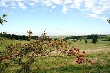
The Lincolnshire Wolds is a range of hill
s in the county
of Lincolnshire
, England
. It is a designated Area of Outstanding Natural Beauty
(AONB), and the highest area of land in eastern England
between Yorkshire
and Kent
. They run roughly parallel with the North Sea
coast, from the River Humber in the northwest to the town of Spilsby
in the southeast.
and limestone
) and sandstone
rock, laid down in the Cretaceous
period. The characteristic open valleys of the Wolds were created during the last glacial period
through the action of glaciation and meltwater.
Geographically, the Lincolnshire Wolds is a continuation of the Yorkshire Wolds
which runs up through the East Riding of Yorkshire
, the Wolds as a whole having been bisected by the tremendous erosive power of the waters of the River Humber.
The Lincolnshire Wolds can be divided into four distinct areas:
The Red Hill nature reserve
near the village of Goulceby is notable for the unusual red colour of its soil and underlying chalk.
Wolds Top
is the highest point in the whole of Lincolnshire and is marked by a trig point
just north of the village of Normanby-le-Wold, at approximately 168 metres (551 feet) above sea level .
Other hills include:
The Wolds provide view
s across the flat fens and salt marsh
es of Lindsey
and Holland
: it is possible, from various points on the Wolds, to see all of the larger structures in the north and east of the county: the Belmont mast
, Boston Stump, Grimsby Dock Tower
, the Humber Bridge
, Lincoln Cathedral
, St James' Church in Louth
(known locally as 'The Cathedral of the Wolds', though it holds only parish church status), the radar
station near Normanby, Tattershall Castle, and the wind turbine
s on the coast near Mablethorpe
.
(AONB) in 1973, and are managed as such by the Lincolnshire Wolds Countryside Service.
The Wolds Area of Outstanding Natural Beauty covers 560 square kilometres, while the Countryside Service recognise a wider Lincolnshire Wolds Character/Natural Area which incorporates the AONB and the neighbouring areas of the (geographical) Wolds to the north and south, which are not covered by the AONB.
The Wolds AONB cuts across the council boundaries of Lincolnshire County Council, East Lindsey
District Council, West Lindsey
District Council and North East Lincolnshire
Council.
The boundaries of the AONB are marked by tourist signs incorporating stylized hills and trees, placed on roads leading into and out of the Wolds. The placing of these signs has not been uncontroversial, with some residents unhappy that they outline only the Wolds AONB and not the cultural/geographical area as a whole.
character. They are 'ringed' by several small market town
s that lie around their edge:
Many of the placenames in the Wolds indicate a strong Viking
influence in the area's history. There is also an abundance of mediaeval
'lost villages
' - settlements abandoned due to changes in land use, soil exhaustion
and disease.
Several notable roads and paths run over the Wolds. Caistor High Street, the path of a Roman Road
and now the route of the B1225, runs from Caistor to Baumber
near Horncastle. The lonely Bluestone Heath Road
follows the course of an ancient drove road from west to east across the Wolds, and several "A" roads
also run through the AONB.
The Wolds are now promoted as a tourist destination: the area's connection with Tennyson
(who was born in Somersby) is being exploited, and farmer
s are being encouraged to diversify into the tourism industry. The roads of the Wolds are particularly popular with motorcyclists
, and the area is home to Cadwell Park
, one of the UK's top race
circuits.
The area is also popular with hikers
: the Viking Way
long-distance footpath
runs from Barton-upon-Humber
in North Lincolnshire across the Lincolnshire Wolds and into Rutland
, and there is a Youth Hostel in the middle of the Wolds at Woody's Top near the village of Tetford
.
Hill
A hill is a landform that extends above the surrounding terrain. Hills often have a distinct summit, although in areas with scarp/dip topography a hill may refer to a particular section of flat terrain without a massive summit A hill is a landform that extends above the surrounding terrain. Hills...
s in the county
County
A county is a jurisdiction of local government in certain modern nations. Historically in mainland Europe, the original French term, comté, and its equivalents in other languages denoted a jurisdiction under the sovereignty of a count A county is a jurisdiction of local government in certain...
of Lincolnshire
Lincolnshire
Lincolnshire is a county in the east of England. It borders Norfolk to the south east, Cambridgeshire to the south, Rutland to the south west, Leicestershire and Nottinghamshire to the west, South Yorkshire to the north west, and the East Riding of Yorkshire to the north. It also borders...
, England
England
England is a country that is part of the United Kingdom. It shares land borders with Scotland to the north and Wales to the west; the Irish Sea is to the north west, the Celtic Sea to the south west, with the North Sea to the east and the English Channel to the south separating it from continental...
. It is a designated Area of Outstanding Natural Beauty
Area of Outstanding Natural Beauty
An Area of Outstanding Natural Beauty is an area of countryside considered to have significant landscape value in England, Wales or Northern Ireland, that has been specially designated by the Countryside Agency on behalf of the United Kingdom government; the Countryside Council for Wales on...
(AONB), and the highest area of land in eastern England
England
England is a country that is part of the United Kingdom. It shares land borders with Scotland to the north and Wales to the west; the Irish Sea is to the north west, the Celtic Sea to the south west, with the North Sea to the east and the English Channel to the south separating it from continental...
between Yorkshire
Yorkshire
Yorkshire is a historic county of northern England and the largest in the United Kingdom. Because of its great size in comparison to other English counties, functions have been increasingly undertaken over time by its subdivisions, which have also been subject to periodic reform...
and Kent
Kent
Kent is a county in southeast England, and is one of the home counties. It borders East Sussex, Surrey and Greater London and has a defined boundary with Essex in the middle of the Thames Estuary. The ceremonial county boundaries of Kent include the shire county of Kent and the unitary borough of...
. They run roughly parallel with the North Sea
North Sea
In the southwest, beyond the Straits of Dover, the North Sea becomes the English Channel connecting to the Atlantic Ocean. In the east, it connects to the Baltic Sea via the Skagerrak and Kattegat, narrow straits that separate Denmark from Norway and Sweden respectively...
coast, from the River Humber in the northwest to the town of Spilsby
Spilsby
Spilsby is a market town and civil parish in Lincolnshire. England. The town is situated adjacent to the main A16 Trunk Road at the southern edge of the Lincolnshire Wolds north of the Fenlands, east of the county town of Lincoln, north east of Boston and north west from Skegness.The town has...
in the southeast.
Geography
The Wolds comprise a series of low hills and steep valleys underlain by calcareous (chalkChalk
Chalk is a soft, white, porous sedimentary rock, a form of limestone composed of the mineral calcite. Calcite is calcium carbonate or CaCO3. It forms under reasonably deep marine conditions from the gradual accumulation of minute calcite plates shed from micro-organisms called coccolithophores....
and limestone
Limestone
Limestone is a sedimentary rock composed largely of the minerals calcite and aragonite, which are different crystal forms of calcium carbonate . Many limestones are composed from skeletal fragments of marine organisms such as coral or foraminifera....
) and sandstone
Sandstone
Sandstone is a sedimentary rock composed mainly of sand-sized minerals or rock grains.Most sandstone is composed of quartz and/or feldspar because these are the most common minerals in the Earth's crust. Like sand, sandstone may be any colour, but the most common colours are tan, brown, yellow,...
rock, laid down in the Cretaceous
Cretaceous
The Cretaceous , derived from the Latin "creta" , usually abbreviated K for its German translation Kreide , is a geologic period and system from circa to million years ago. In the geologic timescale, the Cretaceous follows the Jurassic period and is followed by the Paleogene period of the...
period. The characteristic open valleys of the Wolds were created during the last glacial period
Glacial period
A glacial period is an interval of time within an ice age that is marked by colder temperatures and glacier advances. Interglacials, on the other hand, are periods of warmer climate within an ice age...
through the action of glaciation and meltwater.
Geographically, the Lincolnshire Wolds is a continuation of the Yorkshire Wolds
Yorkshire Wolds
The Yorkshire Wolds are low hills in the counties of East Riding of Yorkshire and North Yorkshire in northeastern England. The name also applies to the district in which the hills lie....
which runs up through the East Riding of Yorkshire
East Riding of Yorkshire
The East Riding of Yorkshire, or simply East Yorkshire, is a local government district with unitary authority status, and a ceremonial county of England. For ceremonial purposes the county also includes the city of Kingston upon Hull, which is a separate unitary authority...
, the Wolds as a whole having been bisected by the tremendous erosive power of the waters of the River Humber.
The Lincolnshire Wolds can be divided into four distinct areas:
- the main area of chalk hills in the north,
- the north west scarpEscarpmentAn escarpment is a steep slope or long cliff that occurs from erosion or faulting and separates two relatively level areas of differing elevations.-Description and variants:...
, - an area of ridges and valleys in the south west,
- the clayClayClay is a general term including many combinations of one or more clay minerals with traces of metal oxides and organic matter. Geologic clay deposits are mostly composed of phyllosilicate minerals containing variable amounts of water trapped in the mineral structure.- Formation :Clay minerals...
lands in the south east.
The Red Hill nature reserve
Nature reserve
A nature reserve is a protected area of importance for wildlife, flora, fauna or features of geological or other special interest, which is reserved and managed for conservation and to provide special opportunities for study or research...
near the village of Goulceby is notable for the unusual red colour of its soil and underlying chalk.
Wolds Top
Wolds Top
Wolds Top is the name sometimes given to the highest point of the Lincolnshire Wolds. It lies some distance to the north of the village of Normanby-le-Wold in Lincolnshire. The Viking Way passes close by, on a minor road, and there is a radio mast near the summit...
is the highest point in the whole of Lincolnshire and is marked by a trig point
Trig point
A triangulation station, also known as a triangulation pillar, trigonometrical station, trigonometrical point, trig station, trig beacon or trig point, and sometimes informally as a trig, is a fixed surveying station, used in geodetic surveying and other surveying projects in its vicinity...
just north of the village of Normanby-le-Wold, at approximately 168 metres (551 feet) above sea level .
Other hills include:
- Castcliffe Hill - - 139 metres (456 ft)
- Gaumer Hill - - 129 metres (423.2 ft)
- Meagram Top - - 58 metres (190.3 ft)
- Warden Hill - - 113 metres (370.7 ft)
- Tetford Hill - - 142 metres (465.9 ft)
- Hoe Hill - - 127 metres (416.7 ft)
The Wolds provide view
View
A view is what can be seen in a range of vision. View may also be used as a synonym of point of view in the first sense. View may also be used figuratively or with special significance—for example, to imply a scenic outlook or significant vantage point:...
s across the flat fens and salt marsh
Salt marsh
A salt marsh is an environment in the upper coastal intertidal zone between land and salt water or brackish water, it is dominated by dense stands of halophytic plants such as herbs, grasses, or low shrubs. These plants are terrestrial in origin and are essential to the stability of the salt marsh...
es of Lindsey
Lindsey
Lindsey was a unit of local government until 1974 in Lincolnshire, England, covering the northern part of the county. The Isle of Axholme, which is on the west side of the River Trent, has normally formed part of it...
and Holland
Holland, Lincolnshire
Holland is an area of south-east Lincolnshire, England. The name is still recognised locally and survives in the district of South Holland.-Administration:...
: it is possible, from various points on the Wolds, to see all of the larger structures in the north and east of the county: the Belmont mast
Belmont transmitting station
The Belmont transmitting station is a broadcasting and telecommunications facility, situated next to the B1225, one mile west of the village of Donington on Bain in the civil parish of South Willingham, near Market Rasen and Louth in Lincolnshire, England . It is owned and operated by Arqiva.It has...
, Boston Stump, Grimsby Dock Tower
Grimsby Dock Tower
Grimsby Dock Tower is a hydraulic accumulator tower and a famous maritime landmark in Grimsby, North East Lincolnshire, England. It was completed on 27 March 1852 with the purpose of containing a 30,000 UK gallon hydraulic wrought iron reservoir at a height of , to provide hydraulic power to...
, the Humber Bridge
Humber Bridge
The Humber Bridge, near Kingston upon Hull, England, is a 2,220 m single-span suspension bridge, which opened to traffic on 24 June 1981. It is the fifth-largest of its type in the world...
, Lincoln Cathedral
Lincoln Cathedral
Lincoln Cathedral is a historic Anglican cathedral in Lincoln in England and seat of the Bishop of Lincoln in the Church of England. It was reputedly the tallest building in the world for 249 years . The central spire collapsed in 1549 and was not rebuilt...
, St James' Church in Louth
Louth, Lincolnshire
Louth is a market town and civil parish within the East Lindsey district of Lincolnshire, England.-Geography:Known as the "capital of the Lincolnshire Wolds", it is situated where the ancient trackway Barton Street crosses the River Lud, and has a total resident population of 15,930.The Greenwich...
(known locally as 'The Cathedral of the Wolds', though it holds only parish church status), the radar
Radar
Radar is an object-detection system which uses radio waves to determine the range, altitude, direction, or speed of objects. It can be used to detect aircraft, ships, spacecraft, guided missiles, motor vehicles, weather formations, and terrain. The radar dish or antenna transmits pulses of radio...
station near Normanby, Tattershall Castle, and the wind turbine
Wind turbine
A wind turbine is a device that converts kinetic energy from the wind into mechanical energy. If the mechanical energy is used to produce electricity, the device may be called a wind generator or wind charger. If the mechanical energy is used to drive machinery, such as for grinding grain or...
s on the coast near Mablethorpe
Mablethorpe
Mablethorpe is a small seaside town in East Lindsey on the coast of Lincolnshire, England.-Geography:Several small caravan parks exist around Mablethorpe. The town is administered with Sutton-on-Sea and Trusthorpe, as the civil parish of Mablethorpe and Sutton...
.
AONB
The Lincolnshire Wolds were designated an Area of Outstanding Natural BeautyArea of Outstanding Natural Beauty
An Area of Outstanding Natural Beauty is an area of countryside considered to have significant landscape value in England, Wales or Northern Ireland, that has been specially designated by the Countryside Agency on behalf of the United Kingdom government; the Countryside Council for Wales on...
(AONB) in 1973, and are managed as such by the Lincolnshire Wolds Countryside Service.
The Wolds Area of Outstanding Natural Beauty covers 560 square kilometres, while the Countryside Service recognise a wider Lincolnshire Wolds Character/Natural Area which incorporates the AONB and the neighbouring areas of the (geographical) Wolds to the north and south, which are not covered by the AONB.
The Wolds AONB cuts across the council boundaries of Lincolnshire County Council, East Lindsey
East Lindsey
East Lindsey is a local government district in Lincolnshire, England. The council is based in Manby near Louth, and other major settlements in the district include Alford, Spilsby, Mablethorpe, Skegness, Horncastle and Chapel St Leonards....
District Council, West Lindsey
West Lindsey
West Lindsey is a local government district in Lincolnshire, England.-History:The district was formed on 1 April 1974, from the urban districts of Gainsborough, Market Rasen, along with Caistor Rural District, Gainsborough Rural District and Welton Rural District...
District Council and North East Lincolnshire
North East Lincolnshire
North East Lincolnshire is a unitary authority in the Yorkshire and the Humber region of England, bordering the unitary authority of North Lincolnshire and the administrative county of Lincolnshire...
Council.
The boundaries of the AONB are marked by tourist signs incorporating stylized hills and trees, placed on roads leading into and out of the Wolds. The placing of these signs has not been uncontroversial, with some residents unhappy that they outline only the Wolds AONB and not the cultural/geographical area as a whole.
People and places
The Wolds are sparsely populated and have a ruralRural
Rural areas or the country or countryside are areas that are not urbanized, though when large areas are described, country towns and smaller cities will be included. They have a low population density, and typically much of the land is devoted to agriculture...
character. They are 'ringed' by several small market town
Market town
Market town or market right is a legal term, originating in the medieval period, for a European settlement that has the right to host markets, distinguishing it from a village and city...
s that lie around their edge:
- AlfordAlford, Lincolnshire- Notable residents :* Captain John Smith who lived in nearby Willoughby* Anne Hutchinson, pioneer settler and religious reformer in the United States* Thomas Paine, who was an excise officer in the town....
- Horncastle, billed on tourist signs as the "gateway to the Wolds", lies just outside the south end of the AONB
- LouthLouth, LincolnshireLouth is a market town and civil parish within the East Lindsey district of Lincolnshire, England.-Geography:Known as the "capital of the Lincolnshire Wolds", it is situated where the ancient trackway Barton Street crosses the River Lud, and has a total resident population of 15,930.The Greenwich...
, "the capital of the Wolds" - Market RasenMarket RasenMarket Rasen is a town and civil parish within the West Lindsey district of Lincolnshire, England. It lies on the River Rase northeast of Lincoln, east of Gainsborough and southwest of Grimsby. According to the 2001 census, it has a population of 3,200....
- CaistorCaistorSee Caistor St Edmund for the Roman settlement in Norfolk or Caister-on-Sea for the town in NorfolkCaistor is a town and civil parish situated in the West Lindsey district of Lincolnshire, England. As its name implies, it was originally a Roman castrum or fortress...
- SpilsbySpilsbySpilsby is a market town and civil parish in Lincolnshire. England. The town is situated adjacent to the main A16 Trunk Road at the southern edge of the Lincolnshire Wolds north of the Fenlands, east of the county town of Lincoln, north east of Boston and north west from Skegness.The town has...
Many of the placenames in the Wolds indicate a strong Viking
Viking
The term Viking is customarily used to refer to the Norse explorers, warriors, merchants, and pirates who raided, traded, explored and settled in wide areas of Europe, Asia and the North Atlantic islands from the late 8th to the mid-11th century.These Norsemen used their famed longships to...
influence in the area's history. There is also an abundance of mediaeval
Middle Ages
The Middle Ages is a periodization of European history from the 5th century to the 15th century. The Middle Ages follows the fall of the Western Roman Empire in 476 and precedes the Early Modern Era. It is the middle period of a three-period division of Western history: Classic, Medieval and Modern...
'lost villages
Abandoned village
An abandoned village is a village that has, for some reason, been deserted. In many countries, and throughout history, thousands of villages were deserted for a variety of causes...
' - settlements abandoned due to changes in land use, soil exhaustion
Soils retrogression and degradation
Soil retrogression and degradation are two regressive evolution processes associated with the loss of equilibrium of a stable soil. Retrogression is primarily due to erosion and corresponds to a phenomenon where succession reverts back to pioneer conditions . Degradation is an evolution,...
and disease.
Several notable roads and paths run over the Wolds. Caistor High Street, the path of a Roman Road
Roman road
The Roman roads were a vital part of the development of the Roman state, from about 500 BC through the expansion during the Roman Republic and the Roman Empire. Roman roads enabled the Romans to move armies and trade goods and to communicate. The Roman road system spanned more than 400,000 km...
and now the route of the B1225, runs from Caistor to Baumber
Baumber
Baumber is a village and civil parish in the East Lindsey district of Lincolnshire, England, about four miles north of Horncastle. It lies at the junction of the B1225 and the A158.According to the 2001 census Baumber had a population of 168....
near Horncastle. The lonely Bluestone Heath Road
Bluestone Heath Road
The Bluestone Heath Road is an ancient road across the Lincolnshire Wolds in Lincolnshire, England.-Route:The route begins at Candlesby and runs northbound to Caistor, following closely an ancient ridge trail across the spine of the wold...
follows the course of an ancient drove road from west to east across the Wolds, and several "A" roads
Great Britain road numbering scheme
The Great Britain road numbering scheme is a numbering scheme used to classify and identify all roads in Great Britain. Each road is given a single letter, which represents the road's category, and a subsequent number, with a length of between 1 and 4 digits. Originally introduced to arrange...
also run through the AONB.
The Wolds are now promoted as a tourist destination: the area's connection with Tennyson
Alfred Tennyson, 1st Baron Tennyson
Alfred Tennyson, 1st Baron Tennyson, FRS was Poet Laureate of the United Kingdom during much of Queen Victoria's reign and remains one of the most popular poets in the English language....
(who was born in Somersby) is being exploited, and farmer
Farmer
A farmer is a person engaged in agriculture, who raises living organisms for food or raw materials, generally including livestock husbandry and growing crops, such as produce and grain...
s are being encouraged to diversify into the tourism industry. The roads of the Wolds are particularly popular with motorcyclists
Motorcycle
A motorcycle is a single-track, two-wheeled motor vehicle. Motorcycles vary considerably depending on the task for which they are designed, such as long distance travel, navigating congested urban traffic, cruising, sport and racing, or off-road conditions.Motorcycles are one of the most...
, and the area is home to Cadwell Park
Cadwell Park
Cadwell Park is a motor racing circuit in Lincolnshire, England, south of Louth. It is owned and operated by Jonathan Palmer's Motorsport Vision company....
, one of the UK's top race
Auto racing
Auto racing is a motorsport involving the racing of cars for competition. It is one of the world's most watched televised sports.-The beginning of racing:...
circuits.
The area is also popular with hikers
Hiking
Hiking is an outdoor activity which consists of walking in natural environments, often in mountainous or other scenic terrain. People often hike on hiking trails. It is such a popular activity that there are numerous hiking organizations worldwide. The health benefits of different types of hiking...
: the Viking Way
Viking Way
The Viking Way is a long distance footpath in England running between the Humber Bridge in North Lincolnshire and Oakham in Rutland. The Countryside Commission recognised the significance of the Viking Way as a high quality long distance walk linking other major routes in Eastern England, these...
long-distance footpath
Long-distance trail
Long-distance trails are the longer recreational trails mainly through rural areas, used for non-motorised recreational travelling ....
runs from Barton-upon-Humber
Barton-upon-Humber
Barton-upon-Humber or Barton is a small town and civil parish in North Lincolnshire, England located on the south bank of the Humber Estuary, and at the end of the Humber Bridge. It lies east of Leeds, southwest of Hull and north northeast of the county town of Lincoln...
in North Lincolnshire across the Lincolnshire Wolds and into Rutland
Rutland
Rutland is a landlocked county in central England, bounded on the west and north by Leicestershire, northeast by Lincolnshire and southeast by Peterborough and Northamptonshire....
, and there is a Youth Hostel in the middle of the Wolds at Woody's Top near the village of Tetford
Tetford
Tetford is both a village and a parish in the Lincolnshire Wolds, northeast of Horncastle, south of Louth and northwest of Spilsby. It is in a shallow valley, situated at the bottom of a 98 m high ridge on which runs the Bluestone Heath Road...
.