

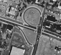
Jughandle
Encyclopedia
Occasionally a setup is used where traffic on the side road cannot turn left at the intersection but turns left after it, merging with the main road. This is most often used for U-turns where a normal jughandle cannot be constructed; traffic turns left off the main road onto the ramp.
Occasionally, a jughandle is removed if turning traffic is too heavy (see Disadvantages). In at least one case (Route 36
Route 36 (New Jersey)
Route 36 is a state highway in Monmouth County, New Jersey, United States. The long route, shaped as a backwards C, begins at an intersection with Garden State Parkway and County Route 51 in Eatontown and runs east to Long Branch. From Long Branch, the route follows the Atlantic Ocean north to...
at Route 71
Route 71 (New Jersey)
Route 71 is a state highway in New Jersey, United States, running near the shore in Monmouth County. It begins at Route 35 in Brielle, just north of the Manasquan River and the Ocean County line, and heads north to Route 35 in Eatontown, with a four-block concurrency with Route 35 in Belmar...
) in New Jersey
New Jersey
New Jersey is a state in the Northeastern and Middle Atlantic regions of the United States. , its population was 8,791,894. It is bordered on the north and east by the state of New York, on the southeast and south by the Atlantic Ocean, on the west by Pennsylvania and on the southwest by Delaware...
, the jughandle was kept for U-turns, but left turns are made from a left-turn lane.
NJDOT
New Jersey Department of Transportation
The New Jersey Department of Transportation is the agency responsible for transportation issues and policy in New Jersey. It is headed by the Commissioner of Transportation...
defines three types of jughandles. "Type A" is the standard forward jughandle. "Type B" is a variant with no cross-street intersected by the jughandle; it curves 90 degrees left to meet the main street, and is either used at a "T" intersection or for a U-turn only. "Type C" is the standard reverse jughandle.
Usage
States that use jughandles prevalently include New JerseyNew Jersey
New Jersey is a state in the Northeastern and Middle Atlantic regions of the United States. , its population was 8,791,894. It is bordered on the north and east by the state of New York, on the southeast and south by the Atlantic Ocean, on the west by Pennsylvania and on the southwest by Delaware...
, Pennsylvania
Pennsylvania
The Commonwealth of Pennsylvania is a U.S. state that is located in the Northeastern and Mid-Atlantic regions of the United States. The state borders Delaware and Maryland to the south, West Virginia to the southwest, Ohio to the west, New York and Ontario, Canada, to the north, and New Jersey to...
, Connecticut
Connecticut
Connecticut is a state in the New England region of the northeastern United States. It is bordered by Rhode Island to the east, Massachusetts to the north, and the state of New York to the west and the south .Connecticut is named for the Connecticut River, the major U.S. river that approximately...
, Delaware
Delaware
Delaware is a U.S. state located on the Atlantic Coast in the Mid-Atlantic region of the United States. It is bordered to the south and west by Maryland, and to the north by Pennsylvania...
, the District of Columbia, Illinois
Illinois
Illinois is the fifth-most populous state of the United States of America, and is often noted for being a microcosm of the entire country. With Chicago in the northeast, small industrial cities and great agricultural productivity in central and northern Illinois, and natural resources like coal,...
, Ohio
Ohio
Ohio is a Midwestern state in the United States. The 34th largest state by area in the U.S.,it is the 7th‑most populous with over 11.5 million residents, containing several major American cities and seven metropolitan areas with populations of 500,000 or more.The state's capital is Columbus...
, Maryland
Maryland
Maryland is a U.S. state located in the Mid Atlantic region of the United States, bordering Virginia, West Virginia, and the District of Columbia to its south and west; Pennsylvania to its north; and Delaware to its east...
, Massachusetts
Massachusetts
The Commonwealth of Massachusetts is a state in the New England region of the northeastern United States of America. It is bordered by Rhode Island and Connecticut to the south, New York to the west, and Vermont and New Hampshire to the north; at its east lies the Atlantic Ocean. As of the 2010...
, Michigan
Michigan
Michigan is a U.S. state located in the Great Lakes Region of the United States of America. The name Michigan is the French form of the Ojibwa word mishigamaa, meaning "large water" or "large lake"....
, Minnesota
Minnesota
Minnesota is a U.S. state located in the Midwestern United States. The twelfth largest state of the U.S., it is the twenty-first most populous, with 5.3 million residents. Minnesota was carved out of the eastern half of the Minnesota Territory and admitted to the Union as the thirty-second state...
, Missouri
Missouri
Missouri is a US state located in the Midwestern United States, bordered by Iowa, Illinois, Kentucky, Tennessee, Arkansas, Oklahoma, Kansas and Nebraska. With a 2010 population of 5,988,927, Missouri is the 18th most populous state in the nation and the fifth most populous in the Midwest. It...
, New York
New York
New York is a state in the Northeastern region of the United States. It is the nation's third most populous state. New York is bordered by New Jersey and Pennsylvania to the south, and by Connecticut, Massachusetts and Vermont to the east...
, New Hampshire
New Hampshire
New Hampshire is a state in the New England region of the northeastern United States of America. The state was named after the southern English county of Hampshire. It is bordered by Massachusetts to the south, Vermont to the west, Maine and the Atlantic Ocean to the east, and the Canadian...
, and Vermont
Vermont
Vermont is a state in the New England region of the northeastern United States of America. The state ranks 43rd in land area, , and 45th in total area. Its population according to the 2010 census, 630,337, is the second smallest in the country, larger only than Wyoming. It is the only New England...
. Jughandles are particularly associated with New Jersey.
Some states use a limited number of jughandles:
- In North CarolinaNorth CarolinaNorth Carolina is a state located in the southeastern United States. The state borders South Carolina and Georgia to the south, Tennessee to the west and Virginia to the north. North Carolina contains 100 counties. Its capital is Raleigh, and its largest city is Charlotte...
, one jughandle exists at the intersection of Patton Ave and Clingman Ave in southwest Asheville. Westbound Patton Ave vehicles cannot turn left onto Clingman Ave. - In OregonOregonOregon is a state in the Pacific Northwest region of the United States. It is located on the Pacific coast, with Washington to the north, California to the south, Nevada on the southeast and Idaho to the east. The Columbia and Snake rivers delineate much of Oregon's northern and eastern...
, a full set of jughandles was recently installed at the at-grade intersection of the Bend ParkwayU.S. Route 97 in OregonIn the U.S. state of Oregon, U.S. Route 97 is a major north–south United States highway which runs through the state of Oregon . In Oregon, it runs from the Oregon-California border, south of Klamath Falls, to the Oregon-Washington border on the Columbia River, between Biggs Junction, Oregon and...
and SW Powers Road in BendBend, OregonBend is a city in and the county seat of Deschutes County, Oregon, United States, and the principal city of the Bend, Oregon Metropolitan Statistical Area. Bend is Central Oregon's largest city, and, despite its modest size, is the de facto metropolis of the region, owing to the low population...
; no left turns are allowed through the intersection between the parkway and the local road. , a jughandle is being installed in Oregon CityOregon City, OregonOregon City was the first city in the United States west of the Rocky Mountains to be incorporated. It is the county seat of Clackamas County, Oregon...
. - In Rhode IslandRhode IslandThe state of Rhode Island and Providence Plantations, more commonly referred to as Rhode Island , is a state in the New England region of the United States. It is the smallest U.S. state by area...
, some are being built in southern Rhode Island on U.S. Route 1. - In South CarolinaSouth CarolinaSouth Carolina is a state in the Deep South of the United States that borders Georgia to the south, North Carolina to the north, and the Atlantic Ocean to the east. Originally part of the Province of Carolina, the Province of South Carolina was one of the 13 colonies that declared independence...
, jughandles exist on US 17 through the Charleston peninsula, which is also known as the Crosstown. This is between King and Spring Streets in both directions. - In VirginiaVirginiaThe Commonwealth of Virginia , is a U.S. state on the Atlantic Coast of the Southern United States. Virginia is nicknamed the "Old Dominion" and sometimes the "Mother of Presidents" after the eight U.S. presidents born there...
, a jughandle was built in May 2011 at the intersection of US 29/460 at Concord Turnpike in LynchburgLynchburg, VirginiaLynchburg is an independent city in the Commonwealth of Virginia. The population was 75,568 as of 2010. Located in the foothills of the Blue Ridge Mountains along the banks of the James River, Lynchburg is known as the "City of Seven Hills" or "The Hill City." Lynchburg was the only major city in...
. This is to connect the former four-lane US 460 section that pre-dated the US 29 Lynchburg Bypass in the mid-2000's.
History
The first mention of jughandles in the New York Times is on June 14, 1959, referring to jughandles having been built on US 46 in Montville, US 22 between North PlainfieldNorth Plainfield, New Jersey
North Plainfield is a Borough in Somerset County, New Jersey, United States. As of the 2010 United States Census, the borough population was 21,936....
and Bound Brook
Bound Brook, New Jersey
Bound Brook is a borough in Somerset County, New Jersey, United States. At the United States 2010 Census, the population was 10,402.Bound Brook was originally incorporated as a town by an Act of the New Jersey Legislature on March 24, 1869, within portions of Bridgewater Township...
, and Route 35
Route 35 (New Jersey)
Route 35 is a state highway in the U.S. state of New Jersey, primarily traveling through the easternmost parts of Middlesex, Monmouth, and Ocean counties. It runs from the entrance to Island Beach State Park in Berkeley Township, Ocean County to an intersection with Route 27 in Rahway, Union County...
at Monmouth Park Racetrack
Monmouth Park Racetrack
Monmouth Park Racetrack is an American race track for thoroughbred horse racing in Oceanport, New Jersey. It is owned by the New Jersey Sports and Exposition Authority and is operated under a five-year lease as a partnership with Resorts Casino Hotel in Atlantic City.Monmouth Park's marquee event...
.
By the beginning of 1960, New Jersey had 160 jughandles, most if not all standard before-intersection jughandles. The 160th one was on U.S. Route 1
U.S. Route 1
U.S. Route 1 is a major north–south U.S. Highway that serves the East Coast of the United States. It runs 2,377 miles from Fort Kent, Maine at the Canadian border south to Key West, Florida. U.S. 1 generally parallels Interstate 95, though it is significantly farther west between...
between New Brunswick
New Brunswick, New Jersey
New Brunswick is a city in Middlesex County, New Jersey, USA. It is the county seat and the home of Rutgers University. The city is located on the Northeast Corridor rail line, southwest of Manhattan, on the southern bank of the Raritan River. At the 2010 United States Census, the population of...
and Trenton
Trenton, New Jersey
Trenton is the capital of the U.S. state of New Jersey and the county seat of Mercer County. As of the 2010 United States Census, Trenton had a population of 84,913...
.
Signage
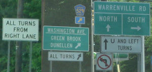
On New Jersey State Highways and Pennsylvania State Highways, a white sign is placed before a jughandle or at the beginning of a stretch of jughandles saying ALL TURNS FROM RIGHT LANE. Each jughandle is marked with a white sign below the standard green sign, saying ALL TURNS, or U AND LEFT TURNS in the case of a reverse jughandle.On locally maintained roads, and in other states, jughandle signage can appear to be haphazard and confusing to out of state drivers.
Generally on Pennsylvania Route 61
Pennsylvania Route 61
Pennsylvania Route 61 is an -long state highway in the U.S. state of Pennsylvania. The route is signed on a north–south direction, from U.S. Route 222 Business in Reading to U.S. Route 11 and U.S. Route 15 in Shamokin Dam. PA 61 meets up with Pennsylvania Route 54 in Ashland and these...
, jughandles are common, and are signed as "All Turns (up/right arrow)".
Advantages
- Safety
- Removes left-turning vehicles from travel lanes, particularly from higher-speed left lanes.
- Pedestrian crossing distance is reduced across the mainline.
- Reduced left-turn conflict points as compared to a standard four-leg intersection.
- Removes conflicts with right-turning vehicles and pedestrians/bicyclists at the primary intersection.
- Operations
- Reduced overall travel time and delay through the intersection.
- Reduced signal phases due to the elimination of the associated left-turn phase(s).
- Increases queuing space for left-turning vehicles.
- Shorter pedestrian crossing distance across the mainline may provide for shorter cross street signal phases.
- May improve U-turns by reducing the need for a tight-radius turning maneuver which conflicts with cross-street right-turns.
Disadvantages
- Safety
- Driver confusion, due to left-turns being made from the right side of the roadway — an uncommon configuration outside of the northeastern United States. Expectancy issues may be compounded due to inconsistency between intersections, where some intersections may be jughandles and others may be standard intersections. These issues can be reduced through advance signing.
- Pedestrian conflict is increased along the cross street due to the addition of an additional intersecting approach.
- Creates a higher-speed conflict between vehicles and pedestrians/bicyclists at the divergence point of the jughandle ramp.
- Operations
- Increased travel time and delay for left-turning motorists redirected through jughandle.
- Increased overall percentage of vehicles stopped at the intersection.
- Potential for queues along the cross street to block the exit terminal of the jughandle, increasing stops, delays, and travel time of left-turning motorists.
- With reverse jughandles, motorists travel through the intersection twice: adding to the net movement demand.
- Motorists wishing to perform a U-turn maneuver at a reverse jughandle must perform a weaving maneuver across all cross-street lanes to travel from the jughandle terminus to the left-turn lane (unless another reverse jughandle is located on the other corner on the side of the cross street ahead of the motorist's original direction, in which case the motorist stays on the right but must cross through the intersection three times).
- To provide for motorist safety, the Federal Highway Administration recommends locating transit stops further from the intersection, outside of the jughandle ramps. This can reduce pedestrian demand due to the additional travel distance to access the transit stop.
- "Type A" standard forward jughandles can encourage drivers to try beating (bypassing) the stopped redlight traffic by driving into the jughandle, turning left, and then turning right onto the original roadway to proceed in the original direction of travel prior to that roadway's light turning green again and releasing the stopped traffic.
- Right-of-way
- Additional right-of-way may be required alongside the roadway, unless the existing street network can be utilized.
See also
- Continuous-flow intersection
- Diverging diamond interchangeDiverging diamond interchangeA diverging diamond interchange is a rare form of diamond interchange in which the two directions of traffic on the non-freeway road cross to the opposite side on both sides of the bridge at the freeway. It is unusual in that it requires traffic on the freeway overpass to briefly drive on the...
- Hook turnHook turnA hook turn is a traffic-control mechanism where cars that would normally have to turn across oncoming traffic are made to turn across all lanes of traffic instead....
- Michigan leftMichigan leftA Michigan left is an at-grade intersection design which replaces each left turn with a permutation of a U-turn and a right turn. The design was given the name due to its frequent use along Michigan roads and highways since the late 1960s. In other contexts, the intersection is called a median...
- SuperstreetSuperstreetA superstreet is a type of road intersection that is a variation of the Michigan left. In this configuration, traffic on the minor road is not permitted to proceed straight across the major road or highway; traffic wishing to turn left or go straight must turn right onto the major road, make a...
External links
- Federal Highway AdministrationFederal Highway AdministrationThe Federal Highway Administration is a division of the United States Department of Transportation that specializes in highway transportation. The agency's major activities are grouped into two "programs," the Federal-aid Highway Program and the Federal Lands Highway Program...
, Alternative Intersection Treatments - Jughandle - Traffic Performance of Three Typical Designs of New Jersey Jughandle Intersections
- Federal Highway Administration - Signalized Intersections: Informational Guide - Jughandle
- New Jersey Department of Transportation Roadway Design Manual - Diagrams of Jughandles