
.gif)
Route 35 (New Jersey)
Encyclopedia
Route 35 is a state highway
in the U.S. state of New Jersey
, primarily traveling through the easternmost parts of Middlesex
, Monmouth
, and Ocean
counties. It runs 58.11 mi (93.52 km) from the entrance to Island Beach State Park
in Berkeley Township
, Ocean County to an intersection with Route 27 in Rahway
, Union County
. Between Seaside Park
and Mantoloking
, Route 35 follows the right-of-way of the former Pennsylvania Railroad
along the Jersey Shore
. The route heads through Point Pleasant Beach
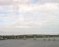
and crosses the Manasquan River
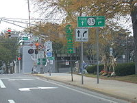
on the Brielle Bridge, meeting Route 34 and Route 70 at the former Brielle Circle
in Wall Township
. From there, Route 35 heads north and intersects Route 138, an extension of Interstate 195
, continuing north through Monmouth County before crossing the Victory Bridge
over the Raritan River
into Perth Amboy
, where the route continues north to Rahway.
Route 35 was designated in 1927 to run from Lakewood to South Amboy, replacing Pre-1927 Route 4 from Lakewood to Belmar and from Eatontown to South Amboy. It was realigned onto its current alignment between Brielle and Belmar in 1929 and saw a northward extension along U.S. Route 9 from South Amboy to Iselin
in 1947. In 1953, Route 35 was realigned to run from Point Pleasant to Seaside Heights
along a former part of Route 37, with Route 35 between Lakewood and Point Pleasant becoming Route 88. At the same time, Route 35 was removed from U.S. Route 9 between South Amboy and Iselin and realigned to follow a former piece of Route 4 between South Amboy and Rahway. From the late 1950s to the mid-1970s, there were plans to build a freeway along the Route 35 corridor from Seaside Heights north into Monmouth County; the only portion that was built became part of Route 18. Route 35 was extended south to the Island Beach State Park entrance by the 1980s. Recent improvements to the route have removed many traffic circle
s and replaced the first cloverleaf interchange
in the United States, built in 1929, at U.S. Route 1/9
in Woodbridge Township
with a partial cloverleaf interchange.
 Route 35 begins at the entrance to Island Beach State Park
in Berkeley Township
, Ocean County
on the Barnegat Peninsula
. It heads north on a divided highway
with parking spaces in the median through residential areas of South Seaside Park. It briefly becomes an undivided highway before crossing into Seaside Park
, where the route becomes four-lane, divided Central Avenue, which also has median parking spaces. Route 35 passes by residences in Seaside Park, with the median widening for the Seaside Park Police Department building at the Sixth Avenue intersection, and then the road widening to six lanes further north. Upon crossing Decatur Street, the southbound lanes of Route 35 run one block to the west of the northbound lanes and then turns to the west, crossing into Seaside Heights
, a beach resort that has a boardwalk and two amusement piers, Casino Pier
and Funtown Pier. In Seaside Heights, Route 35 turns north and interchanges with Route 37 on the Seaside Heights/Berkeley Township border on the eastern shore of Barnegat Bay
. Past the Route 37 interchange, Route 35 continues north along Barnegat Bay, curving eastward and crossing into Toms River Township
, where the route splits into a block-wide one-way pair
with two lanes in each direction that heads north through residential and commercial Ortley Beach. After crossing into Lavallette
a mile later, the northbound direction of Route 35 becomes Grand Central Avenue and the southbound direction of Route 35 becomes Anna O. Hawkins Boulevard. The route then crosses back into Toms River Township, passing through Dover Beaches North
. When Route 35 enters Brick Township
, the northbound direction becomes Ocean Avenue and the one-way pair between the opposing directions of Route 35 narrows as it passes oceanfront residences. Upon crossing into Mantoloking
, Route 35 becomes a two-lane, undivided road and heads north along a narrow peninsula, intersecting the eastern terminus of County Route 528
(Herbert Street) less than a mile later. Route 35 continues north through Bay Head
, becoming Main Avenue, then enters Point Pleasant Beach
, a beach resort with a boardwalk that is home to Jenkinson's Aquarium, where the route swings to the west and turns north onto another one-way pair with two lanes in each direction—the northbound direction following Cincinnati Avenue and the southbound direction following Richmond Avenue. Southbound Route 35 intersects the eastern terminus of Route 88 in this area. The one-way pair carries the route through the downtown area of Point Pleasant Beach. At the County Route 633 (Arnold Avenue) intersection, northbound Route 35 shifts slightly to the west and becomes Hawthorne Avenue. The route becomes a two-way highway again after half a mile and becomes a four-lane divided highway after intersecting County Route 635 (Broadway), almost immediately crossing a channel of the Manasquan River
and entering Monmouth County.
 Route 35 crosses into Brielle
, Monmouth County
, immediately passing over the main channel of the Manasquan River on a drawbridge
. Upon crossing into Brielle, the route interchanges with Ashley Avenue and the southern terminus of Route 71. The route continues northwest and crosses into Wall Township
and meets Route 34 and Route 70 at the former Brielle Circle
, now an at-grade intersection with jughandle
s. Past this intersection, Route 35 heads north on a two-lane, undivided road that passes by many businesses. It meets County Route 524 Spur at the Manasquan Circle, where the Circle Factory Outlet Center is located. Past the Manasquan Circle, Route 35 heads north as a three-lane road with a center left-turn lane that intersects County Route 524
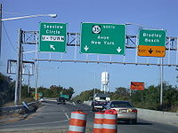
(Allaire Road). Route 35 widens to a four-lane divided highway and interchanges with the eastern terminus of Route 138, which continues west to become Interstate 195
. Route 35 curves to the east and crosses into Belmar
. Here, the route runs along the south bank of the Shark River
as a four-lane undivided highway, intersecting Route 71 again and forming a concurrency
with that route. The two routes continue north along a divided highway until the intersection with 8th Avenue, where Route 71 heads to the east. Past this intersection, Route 35 becomes a two-lane, undivided road again and crosses the Shark River into Neptune Township
.
 Past the Shark River bridge, Route 35 becomes a four-lane divided highway that features an interchange with County Route 40A (Memorial Drive), crossing into Neptune City
. The route continues northwest through residential and commercial areas of Neptune City as a four-lane, undivided highway before heading north as a two-lane, undivided road called Morris Avenue. Route 35 crosses back into Neptune Township, where it becomes Stokes Avenue and crosses Route 33. It continues through suburban development and comes to the Asbury Park Circle where the route intersects County Route 16 (Asbury Avenue), crosses into Ocean Township
, and intersects the eastern terminus of Route 66. The route becomes a four-lane divided highway and passes by the defunct Seaview Square Mall
and continues north through commercial areas, intersecting many roads with jughandles and passing near Weltz County Park. The route becomes Neptune Boulevard at the Talmadge Avenue intersection.
 Route 35 then enters Eatontown
, where it passes by the Monmouth Mall
and intersects Route 36 at the former Eatontown Circle
, now an at-grade intersection with ramps. After that intersection, the route becomes an undivided highway and crosses County Route 547
(Wyckoff Road), where it becomes Broad Street. Past this intersection, Route 35 intersects the northern terminus of Route 71 and County Route 537
, forming a concurrency with County Route 537 that lasts until the Tinton Avenue intersection adjacent to the entrance to Fort Monmouth
. Route 35 crosses into Shrewsbury
and continues north through residential and commercial areas, passing by The Grove at Shrewsbury
. It intersects County Route 520
(Newman Springs Road), running concurrent with that route and immediately crossing into Red Bank
. Upon entering Red Bank, County Route 520, along with County Route 11, head north on Broad Street and Route 35 heads northwest on two-lane Maple Avenue, which turns north and passes by numerous homes. Route 35 splits from Maple Avenue and heads to the northwest on a four-lane road, crossing the Navesink River
into Middletown Township
.
Past the Navesink River, the route runs along a four-lane, divided highway with a jersey barrier
, passing through commercial areas. It crosses under Normandy Road, which serves as a road and railroad link between the two sections of Naval Weapons Station Earle
. Along the northbound lanes of Route 35, just before the intersection of Kings Highway, stands the Evil Clown of Middletown
, a large sign advertising a liquor store. A mixed-use complex, the Middletown Town Center
, is also planned to be built in this area. The route intersects County Route 516
(Cherry Tree Farm Road), running concurrent with that route and entering Holmdel Township
. The concurrency with County Route 516 ends at the intersection with South Laurel Avenue, where that route heads to the north and County Route 52 heads to the south on South Laurel Avenue. Route 35 continues west past numerous businesses and runs through Hazlet
before crossing into Keyport
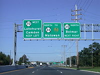
. In Keyport, the route comes to an interchange with the northern terminus of Route 36 that also features access to the Garden State Parkway
. Past this interchange, the road continues northwest and intersects the northern terminus of County Route 3, where it also features ramps to County Route 516, which Route 35 passes under just to the north. Past this interchange, the road crosses the Matawan Creek
into Aberdeen Township
, where it heads northwest through Cliffwood Beach
.
 Route 35 crosses the Whale Creek into Old Bridge Township
, Middlesex County
, where it continues northwest through businesses and residences in Laurence Harbor
and Cliffwood Beach, both sections of Old Bridge Township. It crosses the Cheesequake Creek on a drawbridge into Sayreville
and turns to the west. The road then interchanges with Pine Avenue, which provides access to County Route 615
(Bordentown Avenue). Past this interchange, the route turns north and crosses into South Amboy
, where Route 35 comes to an interchange and forms a concurrency with U.S. Route 9. The two routes head through commercial areas and woodland, interchanging with Raritan Street and Kearney Road, crossing back into Sayreville. U.S. Route 9 and Route 35 split at an interchange (the former Victory Circle
) that features access to the southbound Garden State Parkway by way of Chevalier Avenue, with Route 35 continuing north on a four-lane divided highway that passes through marshland and crosses the Raritan River
on the Victory Bridge
into Perth Amboy
. In Perth Amboy, the route becomes four-lane, undivided Convery Boulevard upon crossing County Route 656 (Smith Street).
The route continues north through commercial and residential sections of Perth Amboy, crossing over a connector to Route 440. It intersects the eastbound direction of Route 184, the former alignment of Route 440, before meeting Route 440 (also an unsigned part of County Route 501
) at an interchange. Route 35 intersects the westbound direction of Route 184 and heads north, crossing into Woodbridge Township
, where it becomes Amboy Avenue. In Woodbridge Township, the route passes by William Warren County Park and crosses over the New Jersey Turnpike
(Interstate 95
). Past the New Jersey Turnpike, the road heads into residential neighborhoods, crossing County Route 514
(Main Street). Route 35 merges onto St. Georges Avenue and comes to a partial cloverleaf interchange with U.S. Route 1/9
. Past U.S. Route 1/9, the road passes homes and businesses, crossing into Rahway
, Union County
just before crossing the Rahway River
. Upon entering Rahway, Route 35 crosses under the Northeast Corridor
rail line just before ending at Route 27. Route 27 continues north on St. Georges Avenue past the terminus of Route 35.
 The present-day alignment of Route 35 follows parts of many 19th-century turnpikes
, including the Keyport and Middletown Turnpike, which was chartered on March 5, 1852, the Middletown Turnpike, chartered in 1866 to run from Middletown Township to Red Bank, the Middletown and Keyport Turnpike, which was chartered on March 15, 1859 to run from Middletown Township to Keyport, the Red Bank and Eatontown Turnpike, chartered on February 9, 1865 along present-day Broad Street, County Route 11, and Route 35, and the Shrewsbury Turnpike, which was chartered in 1857 to run from Red Bank to Eatontown. In 1916, the current alignment of Route 35 was legislated as a part of pre-1927 Route 4 between Point Pleasant
and Brielle and from Eatontown to South Amboy. In the 1927 New Jersey state highway renumbering
, Route 35 was designated to run from Lakewood to South Amboy, replacing pre-1927 Route 4 from Lakewood to Belmar and from Eatontown to South Amboy with the portion of pre-1927 Route 4 between Belmar and Eatontown becoming Route 4N (now Route 71). At this time, U.S. Route 9 followed the portions of Route 35 that were formerly a part of pre-1927 Route 4. By the 1940s, Route 35 was designated onto its current alignment between Brielle and Belmar with the former alignment becoming a southern extension of Route 4N. U.S. Route 9 was also moved off of Route 35 onto a newly completed alignment of Route 4 between Lakewood and South Amboy. In 1947, Route 35 was extended north to end at Route 25 (now U.S. Route 1
) in Iselin
, running concurrent with U.S. Route 9.
In the 1953 New Jersey state highway renumbering
, the portion of Route 35 between Lakewood and Point Pleasant became Route 88 and Route 35 was designated to head south from Point Pleasant to Seaside Heights on what had been a part of Route 37. This section of Route 35 follows the right-of-way of the former Pennsylvania Railroad
Between Seaside Heights and Mantoloking
, with the southbound side following the former railroad right-of-way north of Ortley Beach. Also in the 1953 renumbering, the Route 35 designation was removed from the concurrency with U.S. Route 9 between South Amboy and Iselin and reassigned to the former alignment of Route 4 between South Amboy and Route 27 in Rahway. The western bypass of Seaside Heights was built by the 1960s, extending Route 35 south to the border with Seaside Park.
In the late 1950s, plans were made for a freeway along the Route 35 corridor between Seaside Heights and Long Branch
to reduce congestion along the current route. This proposed freeway was built as Route 18 between Wall Township and Eatontown from 1965 to 1991 while the southern portion to Seaside Heights was never built. In the early 1970s, a Route 35 freeway was planned to run from Route 18 north to the planned Route 74 freeway in Matawan
with an estimated cost of $53 million. This freeway was never built due to the cancellation of the Route 74 freeway in the mid 1970s.
Since the 1953 renumbering, the current alignment of Route 35 has seen many changes and improvements. The section of the route through downtown Point Pleasant Beach was turned into a one-way pair by 1969. Route 35 was extended south to the entrance of Island Beach State Park by the 1980s. Many traffic circles have been removed along Route 35 in recent years, including the Brielle Circle
in 2001 and the Eatontown Circle, which were both converted into at-grade intersections with traffic lights, and the Victory Circle, which was replaced with an interchange between 2003 and 2006. Between 2002 and 2005, the Victory Bridge over the Raritan River was reconstructed at a cost of $109 million. Between February 2006 and November 2008, the cloverleaf interchange
with U.S. Route 1/9 in Woodbridge Township, which was the first cloverleaf interchange in the United States built in 1929 when this portion of Route 35 was still a part of Route 4, was replaced with a partial cloverleaf interchange, costing $34 million.
State highway
State highway, state road or state route can refer to one of three related concepts, two of them related to a state or provincial government in a country that is divided into states or provinces :#A...
in the U.S. state of New Jersey
New Jersey
New Jersey is a state in the Northeastern and Middle Atlantic regions of the United States. , its population was 8,791,894. It is bordered on the north and east by the state of New York, on the southeast and south by the Atlantic Ocean, on the west by Pennsylvania and on the southwest by Delaware...
, primarily traveling through the easternmost parts of Middlesex
Middlesex County, New Jersey
-Demographics:As of the census of 2000, there were 750,162 people, 265,815 households, and 190,855 families residing in the county. The population density was 2,422 people per square mile . There were 273,637 housing units at an average density of 884 per square mile...
, Monmouth
Monmouth County, New Jersey
Monmouth County is a county located in the U.S. state of New Jersey, within the New York metropolitan area. As of the 2010 Census, the population was 630,380, up from 615,301 at the 2000 census. Its county seat is Freehold Borough. The most populous municipality is Middletown Township with...
, and Ocean
Ocean County, New Jersey
-Demographics:As of the census of 2000, there were 510,916 people, 200,402 households, and 137,876 families residing in the county. The population density was 803 people per square mile . There were 248,711 housing units at an average density of 151/km²...
counties. It runs 58.11 mi (93.52 km) from the entrance to Island Beach State Park
Island Beach State Park
Island Beach State Park is a New Jersey state park located just south of Seaside Park on the Barnegat Peninsula in Berkeley Township, Ocean County, New Jersey, United States. The park is operated and maintained by the New Jersey Division of Parks and Forestry...
in Berkeley Township
Berkeley Township, New Jersey
Berkeley Township is a Township in Ocean County, New Jersey, United States. As of the 2010 United States Census, the township population had increased to a record high of 41,255....
, Ocean County to an intersection with Route 27 in Rahway
Rahway, New Jersey
Rahway is a city in southern Union County, New Jersey, United States. It is part of the New York metropolitan area, being 15 miles southwest of Manhattan and five miles west of Staten Island...
, Union County
Union County, New Jersey
Union County is a county located in the U.S. state of New Jersey. As of the 2010 Census, the population was 536,499. It is part of the New York Metropolitan Area. Its county seat is Elizabeth. Union County ranks 93rd among the highest-income counties in the United States. It also ranks 74th in...
. Between Seaside Park
Seaside Park, New Jersey
Seaside Park is a Borough in Ocean County, New Jersey, United States. As of the United States 2010 Census, the borough population was 1,579. Seaside Park is situated on the Barnegat Peninsula, a long, narrow barrier peninsula that separates Barnegat Bay from the Atlantic Ocean.The first inhabitants...
and Mantoloking
Mantoloking, New Jersey
Mantoloking is a Borough in Ocean County, New Jersey, United States . As of the United States 2010 Census, the borough had a total population of 296. The borough has an estimated summer population of approximately 5,000...
, Route 35 follows the right-of-way of the former Pennsylvania Railroad
Pennsylvania Railroad
The Pennsylvania Railroad was an American Class I railroad, founded in 1846. Commonly referred to as the "Pennsy", the PRR was headquartered in Philadelphia, Pennsylvania....
along the Jersey Shore
Jersey Shore
The Jersey Shore is a term used to refer to both the Atlantic coast of the U.S. state of New Jersey and the adjacent resort and residential communities. . The New Jersey State Department of Tourism considers the Shore Region, Greater Atlantic City, and the Southern Shore to be distinct, each having...
. The route heads through Point Pleasant Beach
Point Pleasant Beach, New Jersey
Point Pleasant Beach is a Borough in Ocean County, New Jersey, United States. As of the 2010 United States Census, the borough population was 4,665....
and crosses the Manasquan River
Manasquan River
The Manasquan River is a waterway in central New Jersey. It flows from central Monmouth County, beginning in Freehold Township, to the Atlantic Ocean, where it empties between the communities of Manasquan and Point Pleasant via the Manasquan Inlet. It widens greatly as it nears the ocean, making...
on the Brielle Bridge, meeting Route 34 and Route 70 at the former Brielle Circle
Brielle Circle
The Brielle Circle was a traffic circle in Wall Township, New Jersey, United States, located where Route 34, Route 35, and Route 70 meet. It was the southern end for the never-built Route 18 extension. In 2001 the circle was replaced by an at-grade intersection with jughandles....
in Wall Township
Wall Township, New Jersey
Wall Township is a township in Monmouth County, New Jersey, United States. As of the 2010 United States Census, the township population was 26,164.Wall Township was formally incorporated as a township by an act of the New Jersey Legislature on March 7, 1851...
. From there, Route 35 heads north and intersects Route 138, an extension of Interstate 195
Interstate 195 (New Jersey)
Interstate 195 is an auxiliary route of the Interstate Highway System located in the U.S. state of New Jersey. Its western end is at I-295 and Route 29 just south of Trenton, New Jersey in Hamilton Township, Mercer County while its eastern end is at the Garden State Parkway, Route 34 and Route...
, continuing north through Monmouth County before crossing the Victory Bridge
Victory Bridge (New Jersey)
The Victory Bridge is a highway bridge in the U.S. state of New Jersey that carries Route 35 over the Raritan River, connecting the Middlesex County communities of Perth Amboy on the north and Sayreville to the south. The bridge is operated and maintained by the New Jersey Department of...
over the Raritan River
Raritan River
The Raritan River is a major river of central New Jersey in the United States. Its watershed drains much of the mountainous area of the central part of the state, emptying into the Raritan Bay on the Atlantic Ocean.-Description:...
into Perth Amboy
Perth Amboy, New Jersey
Perth Amboy is a city in Middlesex County, New Jersey, United States. The City of Perth Amboy is part of the New York metropolitan area. As of the 2010 United States Census, the city population was 50,814. Perth Amboy is known as the "City by the Bay", referring to Raritan Bay.-Name:The Lenape...
, where the route continues north to Rahway.
Route 35 was designated in 1927 to run from Lakewood to South Amboy, replacing Pre-1927 Route 4 from Lakewood to Belmar and from Eatontown to South Amboy. It was realigned onto its current alignment between Brielle and Belmar in 1929 and saw a northward extension along U.S. Route 9 from South Amboy to Iselin
Iselin, New Jersey
Iselin is a census-designated place and unincorporated area within Woodbridge Township, in Middlesex County, New Jersey, United States. As of the United States 2000 Census, the CDP population was 16,698.-Geography:...
in 1947. In 1953, Route 35 was realigned to run from Point Pleasant to Seaside Heights
Seaside Heights, New Jersey
Seaside Heights is a Borough in Ocean County, New Jersey, United States. As of the 2010 United States Census, the borough population was 2,887. Seaside Heights is situated on the Barnegat Peninsula, a long, narrow barrier peninsula that separates Barnegat Bay from the Atlantic Ocean...
along a former part of Route 37, with Route 35 between Lakewood and Point Pleasant becoming Route 88. At the same time, Route 35 was removed from U.S. Route 9 between South Amboy and Iselin and realigned to follow a former piece of Route 4 between South Amboy and Rahway. From the late 1950s to the mid-1970s, there were plans to build a freeway along the Route 35 corridor from Seaside Heights north into Monmouth County; the only portion that was built became part of Route 18. Route 35 was extended south to the Island Beach State Park entrance by the 1980s. Recent improvements to the route have removed many traffic circle
Traffic circle
A traffic circle or rotary is a type of circular intersection in which traffic must travel in one direction around a central island. In some countries, traffic entering the circle has the right-of-way and drivers in the circle must yield. In many other countries, traffic entering the circle must...
s and replaced the first cloverleaf interchange
Cloverleaf interchange
A cloverleaf interchange is a two-level interchange in which left turns, reverse direction in left-driving regions, are handled by ramp roads...
in the United States, built in 1929, at U.S. Route 1/9
U.S. Route 1/9
U.S. Route 9 is a U.S. highway in the northeast United States, running from Laurel, Delaware north to the Canadian border near Champlain, New York...
in Woodbridge Township
Woodbridge Township, New Jersey
-Communities:Many distinct communities exist within Woodbridge Township. Several of these communities have their own ZIP codes, and many are listed by the United States Census Bureau as census-designated places, but they are all unincorporated areas and neighborhoods within the Township that,...
with a partial cloverleaf interchange.
Ocean County
Island Beach State Park
Island Beach State Park is a New Jersey state park located just south of Seaside Park on the Barnegat Peninsula in Berkeley Township, Ocean County, New Jersey, United States. The park is operated and maintained by the New Jersey Division of Parks and Forestry...
in Berkeley Township
Berkeley Township, New Jersey
Berkeley Township is a Township in Ocean County, New Jersey, United States. As of the 2010 United States Census, the township population had increased to a record high of 41,255....
, Ocean County
Ocean County, New Jersey
-Demographics:As of the census of 2000, there were 510,916 people, 200,402 households, and 137,876 families residing in the county. The population density was 803 people per square mile . There were 248,711 housing units at an average density of 151/km²...
on the Barnegat Peninsula
Barnegat Peninsula
The Barnegat Peninsula, also known as the Island Beach Peninsula and colloquially as "the barrier island", is a 20-mile long, narrow barrier peninsula located in Ocean County, New Jersey, that divides the Barnegat Bay from the Atlantic Ocean. It is a vacation destination and summer colony area and...
. It heads north on a divided highway
Divided Highway
Divided Highway is a compilation album by American rock band The Doobie Brothers, released in 2003. . All tracks are taken from the albums Cycles and Brotherhood .-Track listing:...
with parking spaces in the median through residential areas of South Seaside Park. It briefly becomes an undivided highway before crossing into Seaside Park
Seaside Park, New Jersey
Seaside Park is a Borough in Ocean County, New Jersey, United States. As of the United States 2010 Census, the borough population was 1,579. Seaside Park is situated on the Barnegat Peninsula, a long, narrow barrier peninsula that separates Barnegat Bay from the Atlantic Ocean.The first inhabitants...
, where the route becomes four-lane, divided Central Avenue, which also has median parking spaces. Route 35 passes by residences in Seaside Park, with the median widening for the Seaside Park Police Department building at the Sixth Avenue intersection, and then the road widening to six lanes further north. Upon crossing Decatur Street, the southbound lanes of Route 35 run one block to the west of the northbound lanes and then turns to the west, crossing into Seaside Heights
Seaside Heights, New Jersey
Seaside Heights is a Borough in Ocean County, New Jersey, United States. As of the 2010 United States Census, the borough population was 2,887. Seaside Heights is situated on the Barnegat Peninsula, a long, narrow barrier peninsula that separates Barnegat Bay from the Atlantic Ocean...
, a beach resort that has a boardwalk and two amusement piers, Casino Pier
Casino Pier
Casino Pier is an amusement park situated on a pier , in Seaside Heights, New Jersey, USA. The pier extends approximately 300 feet into the Atlantic Ocean, from the narrow strip of the Barnegat Peninsula in which Seaside Heights exists...
and Funtown Pier. In Seaside Heights, Route 35 turns north and interchanges with Route 37 on the Seaside Heights/Berkeley Township border on the eastern shore of Barnegat Bay
Barnegat Bay
Barnegat Bay is a small brackish arm of the Atlantic Ocean, approximately 30 miles long, along the coast of Ocean County, New Jersey in the United States. It is a long barrier peninsula, as well as by the north end of Long Beach Island...
. Past the Route 37 interchange, Route 35 continues north along Barnegat Bay, curving eastward and crossing into Toms River Township
Toms River, New Jersey
Toms River is a census-designated place and unincorporated area located within Toms River Township and is the county seat of Ocean County, New Jersey. It is part of a larger Toms River Township...
, where the route splits into a block-wide one-way pair
One-way pair
A one-way pair, one-way couple, or just couplet is a pair of parallel, usually one-way streets that carry opposite directions of a signed route or major traffic flow, or sometimes opposite directions of a bus or streetcar route....
with two lanes in each direction that heads north through residential and commercial Ortley Beach. After crossing into Lavallette
Lavallette, New Jersey
Lavallette is a Borough in Ocean County, New Jersey, United States. As of the United States 2010 Census, the borough population was 1,875. Lavallette is situated on the Barnegat Peninsula, a long, narrow barrier peninsula that separates Barnegat Bay from the Atlantic Ocean.Lavallette was...
a mile later, the northbound direction of Route 35 becomes Grand Central Avenue and the southbound direction of Route 35 becomes Anna O. Hawkins Boulevard. The route then crosses back into Toms River Township, passing through Dover Beaches North
Dover Beaches North, New Jersey
Dover Beaches North is a census-designated place and unincorporated area located within Toms River, in Ocean County, New Jersey. As of the United States 2000 Census, the CDP population was 1,785. The CDP includes the communities of half of Normandy Beach, Normandy Shores, Ocean Beaches 1,2 and 3,...
. When Route 35 enters Brick Township
Brick Township, New Jersey
-Transportation:The major county routes that pass through are CR 528, and CR 549 . Two state routes pass through: Route 70 and Route 88...
, the northbound direction becomes Ocean Avenue and the one-way pair between the opposing directions of Route 35 narrows as it passes oceanfront residences. Upon crossing into Mantoloking
Mantoloking, New Jersey
Mantoloking is a Borough in Ocean County, New Jersey, United States . As of the United States 2010 Census, the borough had a total population of 296. The borough has an estimated summer population of approximately 5,000...
, Route 35 becomes a two-lane, undivided road and heads north along a narrow peninsula, intersecting the eastern terminus of County Route 528
County Route 528 (New Jersey)
County Route 528 is a county highway in the U.S. state of New Jersey. The highway extends from Farnsworth Avenue in Bordentown to Ocean Avenue in Mantoloking.-Burlington County:...
(Herbert Street) less than a mile later. Route 35 continues north through Bay Head
Bay Head, New Jersey
Bay Head is a Borough in Ocean County, New Jersey, United States. As of the 2010 United States Census, the borough population was 968. Bay Head is situated on the Barnegat Peninsula, a long, narrow barrier peninsula that separates Barnegat Bay from the Atlantic Ocean...
, becoming Main Avenue, then enters Point Pleasant Beach
Point Pleasant Beach, New Jersey
Point Pleasant Beach is a Borough in Ocean County, New Jersey, United States. As of the 2010 United States Census, the borough population was 4,665....
, a beach resort with a boardwalk that is home to Jenkinson's Aquarium, where the route swings to the west and turns north onto another one-way pair with two lanes in each direction—the northbound direction following Cincinnati Avenue and the southbound direction following Richmond Avenue. Southbound Route 35 intersects the eastern terminus of Route 88 in this area. The one-way pair carries the route through the downtown area of Point Pleasant Beach. At the County Route 633 (Arnold Avenue) intersection, northbound Route 35 shifts slightly to the west and becomes Hawthorne Avenue. The route becomes a two-way highway again after half a mile and becomes a four-lane divided highway after intersecting County Route 635 (Broadway), almost immediately crossing a channel of the Manasquan River
Manasquan River
The Manasquan River is a waterway in central New Jersey. It flows from central Monmouth County, beginning in Freehold Township, to the Atlantic Ocean, where it empties between the communities of Manasquan and Point Pleasant via the Manasquan Inlet. It widens greatly as it nears the ocean, making...
and entering Monmouth County.
Monmouth County
Brielle, New Jersey
Brielle is a Borough located in southern Monmouth County, New Jersey along the Manasquan River. As of the 2010 United States Census, the borough population was 4,774....
, Monmouth County
Monmouth County, New Jersey
Monmouth County is a county located in the U.S. state of New Jersey, within the New York metropolitan area. As of the 2010 Census, the population was 630,380, up from 615,301 at the 2000 census. Its county seat is Freehold Borough. The most populous municipality is Middletown Township with...
, immediately passing over the main channel of the Manasquan River on a drawbridge
Drawbridge
A drawbridge is a type of movable bridge typically associated with the entrance of a castle surrounded by a moat. The term is often used to describe all different types of movable bridges, like bascule bridges and lift bridges.-Castle drawbridges:...
. Upon crossing into Brielle, the route interchanges with Ashley Avenue and the southern terminus of Route 71. The route continues northwest and crosses into Wall Township
Wall Township, New Jersey
Wall Township is a township in Monmouth County, New Jersey, United States. As of the 2010 United States Census, the township population was 26,164.Wall Township was formally incorporated as a township by an act of the New Jersey Legislature on March 7, 1851...
and meets Route 34 and Route 70 at the former Brielle Circle
Brielle Circle
The Brielle Circle was a traffic circle in Wall Township, New Jersey, United States, located where Route 34, Route 35, and Route 70 meet. It was the southern end for the never-built Route 18 extension. In 2001 the circle was replaced by an at-grade intersection with jughandles....
, now an at-grade intersection with jughandle
Jughandle
A jughandle is a type of ramp or slip road that changes the way traffic turns left at at-grade intersections. Instead of a standard left turn being made from the left lane, left-turning traffic uses a ramp on the right side of the road...
s. Past this intersection, Route 35 heads north on a two-lane, undivided road that passes by many businesses. It meets County Route 524 Spur at the Manasquan Circle, where the Circle Factory Outlet Center is located. Past the Manasquan Circle, Route 35 heads north as a three-lane road with a center left-turn lane that intersects County Route 524
County Route 524 (New Jersey)
County Route 524 is a county highway in the U.S. state of New Jersey. The highway extends from the Whitehorse Circle in Hamilton Township to Route 71 in Spring Lake Heights....
(Allaire Road). Route 35 widens to a four-lane divided highway and interchanges with the eastern terminus of Route 138, which continues west to become Interstate 195
Interstate 195 (New Jersey)
Interstate 195 is an auxiliary route of the Interstate Highway System located in the U.S. state of New Jersey. Its western end is at I-295 and Route 29 just south of Trenton, New Jersey in Hamilton Township, Mercer County while its eastern end is at the Garden State Parkway, Route 34 and Route...
. Route 35 curves to the east and crosses into Belmar
Belmar, New Jersey
Belmar is a borough in Monmouth County, New Jersey, United States. As of the 2010 United States Census, the borough population was 5,794. The Borough of Belmar is governed under the Faulkner Act system of municipal government....
. Here, the route runs along the south bank of the Shark River
Shark River (New Jersey)
The Shark River is a river in eastern New Jersey that rises in eastern Monmouth County and flows southeast for , continuing through Neptune Township and Wall Township...
as a four-lane undivided highway, intersecting Route 71 again and forming a concurrency
Concurrency (road)
A concurrency, overlap, or coincidence in a road network is an instance of one physical road bearing two or more different highway, motorway, or other route numbers...
with that route. The two routes continue north along a divided highway until the intersection with 8th Avenue, where Route 71 heads to the east. Past this intersection, Route 35 becomes a two-lane, undivided road again and crosses the Shark River into Neptune Township
Neptune Township, New Jersey
-Demographics:As of the census of 2000, there were 27,690 people, 10,907 households, and 6,805 families residing in the township. The population density was 3,366.8 people per square mile . There were 12,217 housing units at an average density of 1,485.4 per square mile...
.
Neptune City, New Jersey
Neptune City is a borough in Monmouth County, New Jersey, United States. As of the 2010 United States Census, the borough population was 4,869.The Borough of Neptune City was incorporated on October 4, 1881, based on a referendum held on March 19, 1881...
. The route continues northwest through residential and commercial areas of Neptune City as a four-lane, undivided highway before heading north as a two-lane, undivided road called Morris Avenue. Route 35 crosses back into Neptune Township, where it becomes Stokes Avenue and crosses Route 33. It continues through suburban development and comes to the Asbury Park Circle where the route intersects County Route 16 (Asbury Avenue), crosses into Ocean Township
Ocean Township, Monmouth County, New Jersey
Ocean Township is a township located in east central Monmouth County, New Jersey. As of the 2010 United States Census, the township population was 27,291.Oakhurst and Wanamassa Ocean Township is a township located in east central Monmouth County, New Jersey. As of the 2010 United States Census,...
, and intersects the eastern terminus of Route 66. The route becomes a four-lane divided highway and passes by the defunct Seaview Square Mall
Seaview Square Mall
Seaview Square Mall is a defunct indoor shopping mall located in Ocean Township, in Monmouth County, New Jersey, United States, that has been repurposed as a power center. The mall, located at the intersection of Route 35 and Route 66, was originally constructed in 1977 as an indoor mall...
and continues north through commercial areas, intersecting many roads with jughandles and passing near Weltz County Park. The route becomes Neptune Boulevard at the Talmadge Avenue intersection.
Eatontown, New Jersey
Eatontown is a borough in Monmouth County, New Jersey, United States. As of the 2010 census, the borough population was 12,709.What is now Eatontown was originally incorporated as Eatontown Township by an Act of the New Jersey Legislature on April 4, 1873, from portions of Ocean Township and...
, where it passes by the Monmouth Mall
Monmouth Mall
Monmouth Mall, an enclosed shopping center in Eatontown, New Jersey owned by Vornado Realty Trust, is located on the corner of the intersection of NJ 35, NJ 36, and Wyckoff Road . Currently, the mall has a gross leasable area of , making it the fourth largest shopping mall in New Jersey , boasting...
and intersects Route 36 at the former Eatontown Circle
Eatontown Circle
The Eatontown Circle was a traffic circle in Eatontown, New Jersey, located at the intersection of Route 35, Route 36, Wall Street, and near Wyckoff Road CR 547, near the Monmouth Mall. At the time of its construction, the southwest quadrant was built on a farm owned by the Valentino Family from...
, now an at-grade intersection with ramps. After that intersection, the route becomes an undivided highway and crosses County Route 547
County Route 547 (New Jersey)
County Route 547, abbreviated CR 547, is a county highway in the U.S. state of New Jersey. The highway extends from Route 70 in Lakehurst to Broad Street in Eatontown...
(Wyckoff Road), where it becomes Broad Street. Past this intersection, Route 35 intersects the northern terminus of Route 71 and County Route 537
County Route 537 (New Jersey)
County Route 537, abbreviated CR 537, is a county highway in the U.S. state of New Jersey. The highway extends from Delaware Avenue in Camden to Myrtle Avenue in Long Branch.-Camden County:...
, forming a concurrency with County Route 537 that lasts until the Tinton Avenue intersection adjacent to the entrance to Fort Monmouth
Fort Monmouth
Fort Monmouth was an installation of the Department of the Army in Monmouth County, New Jersey. The post is surrounded by the communities of Eatontown, Tinton Falls and Oceanport, New Jersey, and is located about 5 miles from the Atlantic Ocean. The post covers nearly of land, from the Shrewsbury...
. Route 35 crosses into Shrewsbury
Shrewsbury, New Jersey
Shrewsbury is a borough in Monmouth County, New Jersey, United States. As of the 2010 United States Census, the borough population was 3,809....
and continues north through residential and commercial areas, passing by The Grove at Shrewsbury
The Grove at Shrewsbury
The Grove at Shrewsbury is an upscale lifestyle center located on Route 35 in Shrewsbury, New Jersey, south of downtown Red Bank. The center opened in 1988 and has a gross leasable area of...
. It intersects County Route 520
County Route 520 (New Jersey)
County Route 520 is a county highway in the U.S. state of New Jersey. County Route 520 is a major road across Monmouth County connecting the county's central towns to the Jersey Shore at Sea Bright.-Route description:...
(Newman Springs Road), running concurrent with that route and immediately crossing into Red Bank
Red Bank, New Jersey
-Demographics:As of the census of 2000, there were 11,844 people, 5,201 households, and 2,501 families residing in the borough. The population density was 6,639.1 people per square mile . There were 5,450 housing units at an average density of 3,055.0 per square mile...
. Upon entering Red Bank, County Route 520, along with County Route 11, head north on Broad Street and Route 35 heads northwest on two-lane Maple Avenue, which turns north and passes by numerous homes. Route 35 splits from Maple Avenue and heads to the northwest on a four-lane road, crossing the Navesink River
Navesink River
The Navesink River is an estuary, approximately 8 mi long in Monmouth County, New Jersey, United States. It is surrounded by the communities of Middletown, Red Bank, Fair Haven and Rumson....
into Middletown Township
Middletown Township, New Jersey
Middletown Township is a township in Monmouth County, New Jersey, United States. As of the 2010 United States Census, the township had a total population of 66,522...
.
Past the Navesink River, the route runs along a four-lane, divided highway with a jersey barrier
Jersey barrier
A Jersey barrier or Jersey wall is a modular concrete barrier employed to separate lanes of traffic. It is designed to both minimize vehicle damage in cases of incidental contact while still preventing crossover in the case of head-on accidents....
, passing through commercial areas. It crosses under Normandy Road, which serves as a road and railroad link between the two sections of Naval Weapons Station Earle
Naval Weapons Station Earle
Naval Weapons Station Earle is a United States Navy base in New Jersey. Its distinguishing feature is a 2.9-mile pier in Sandy Hook Bay where ammunition can be loaded and unloaded from warships at a safe distance from land....
. Along the northbound lanes of Route 35, just before the intersection of Kings Highway, stands the Evil Clown of Middletown
Evil Clown of Middletown
The Evil Clown of Middletown is a large outdoor sign on northbound New Jersey Route 35 in Middletown Township, New Jersey, advertising a Spirits Liquor Store.-History:...
, a large sign advertising a liquor store. A mixed-use complex, the Middletown Town Center
Middletown Town Center
The Middletown Town Center is a planned mixed-use complex in Middletown, New Jersey. It is very highly criticized because of traffic concerns along Route 35, and the fact that it will be located in one of the only open space areas in Middletown...
, is also planned to be built in this area. The route intersects County Route 516
County Route 516 (New Jersey)
-Route description:The highway extends 19.27 miles from Route 18/CR 527 in Old Bridge Township to Route 36 in Middletown Township. It is known as Old Bridge-Matawan Road for its entire length in Old Bridge Township where it intersects US 9 then continues several more miles to the Old...
(Cherry Tree Farm Road), running concurrent with that route and entering Holmdel Township
Holmdel Township, New Jersey
Holmdel Township is a township in Monmouth County, New Jersey, United States. As of the 2010 United States Census, the township population was 16,773. Holmdel Township was formed by an Act of the New Jersey Legislature on February 23, 1857, from portions of Raritan Township .Holmdel is a suburb of...
. The concurrency with County Route 516 ends at the intersection with South Laurel Avenue, where that route heads to the north and County Route 52 heads to the south on South Laurel Avenue. Route 35 continues west past numerous businesses and runs through Hazlet
Hazlet, New Jersey
Hazlet Township is a township in Monmouth County, New Jersey, United States. As of the 2010 United States Census, the township population was 20,334....
before crossing into Keyport
Keyport, New Jersey
Keyport is a borough in Monmouth County, New Jersey, United States. As of the 2010 United States Census, the borough population was 7,240. Keyport's nickname is the "Pearl of the Bayshore" or the "Gateway to the Bayshore"....
. In Keyport, the route comes to an interchange with the northern terminus of Route 36 that also features access to the Garden State Parkway
Garden State Parkway
The Garden State Parkway is a 172.4-mile limited-access toll parkway that stretches the length of New Jersey from the New York line at Montvale, New Jersey, to Cape May at New Jersey's southernmost tip. Its name refers to New Jersey's nickname, the "Garden State." Most New Jersey residents refer...
. Past this interchange, the road continues northwest and intersects the northern terminus of County Route 3, where it also features ramps to County Route 516, which Route 35 passes under just to the north. Past this interchange, the road crosses the Matawan Creek
Matawan Creek
Matawan Creek is a creek and partially a tidal estuary of the Atlantic Ocean. It lies in the east central sector of New Jersey across from Staten Island, New York....
into Aberdeen Township
Aberdeen Township, New Jersey
Aberdeen Township is a Township in Monmouth County, New Jersey, United States. As of the 2010 United States Census, the township population was 18,210....
, where it heads northwest through Cliffwood Beach
Cliffwood Beach, New Jersey
Cliffwood Beach is a census-designated place in Monmouth County, New Jersey, United States. The population was 3,194 as of the 2010 census.-Geography:...
.
Middlesex and Union Counties
Old Bridge Township, New Jersey
Old Bridge Township is a Township in Middlesex County, New Jersey, United States. As of the 2000 United States Census, the township had a total population of 60,456...
, Middlesex County
Middlesex County, New Jersey
-Demographics:As of the census of 2000, there were 750,162 people, 265,815 households, and 190,855 families residing in the county. The population density was 2,422 people per square mile . There were 273,637 housing units at an average density of 884 per square mile...
, where it continues northwest through businesses and residences in Laurence Harbor
Laurence Harbor, New Jersey
Laurence Harbor is a census-designated place and unincorporated area located on the Raritan Bay within Old Bridge Township, in Middlesex County, New Jersey. As of the 2000 United States Census, the CDP population was 6,227.-Geography:...
and Cliffwood Beach, both sections of Old Bridge Township. It crosses the Cheesequake Creek on a drawbridge into Sayreville
Sayreville, New Jersey
Sayreville is a borough located on the Raritan River, near Raritan Bay in Middlesex County, New Jersey, United States. As of the 2010 United States Census, the borough population was 42,704....
and turns to the west. The road then interchanges with Pine Avenue, which provides access to County Route 615
County Route 615 (Middlesex County, New Jersey)
County Route 615 is a county route in Middlesex County, New Jersey that measures in length. The road extends from Mercer CR 615 at the Plainsboro/West Windsor line all the way to So. Pine Ave in South Amboy, New Jersey. While most of 615 is not used a commuter road, the section in the...
(Bordentown Avenue). Past this interchange, the route turns north and crosses into South Amboy
South Amboy, New Jersey
South Amboy is a city in Middlesex County, New Jersey, on the Raritan Bay. As of the 2000 United States Census, the city population was 7,913.South Amboy, and Perth Amboy across the Raritan River, are collectively referred to as The Amboys...
, where Route 35 comes to an interchange and forms a concurrency with U.S. Route 9. The two routes head through commercial areas and woodland, interchanging with Raritan Street and Kearney Road, crossing back into Sayreville. U.S. Route 9 and Route 35 split at an interchange (the former Victory Circle
Victory Circle
Victory Circle was a traffic circle where U.S. Route 9 and NJ 35 merged and split in South Amboy, New Jersey, United States. Victory Circle has been replaced by the Victory Interchange....
) that features access to the southbound Garden State Parkway by way of Chevalier Avenue, with Route 35 continuing north on a four-lane divided highway that passes through marshland and crosses the Raritan River
Raritan River
The Raritan River is a major river of central New Jersey in the United States. Its watershed drains much of the mountainous area of the central part of the state, emptying into the Raritan Bay on the Atlantic Ocean.-Description:...
on the Victory Bridge
Victory Bridge (New Jersey)
The Victory Bridge is a highway bridge in the U.S. state of New Jersey that carries Route 35 over the Raritan River, connecting the Middlesex County communities of Perth Amboy on the north and Sayreville to the south. The bridge is operated and maintained by the New Jersey Department of...
into Perth Amboy
Perth Amboy, New Jersey
Perth Amboy is a city in Middlesex County, New Jersey, United States. The City of Perth Amboy is part of the New York metropolitan area. As of the 2010 United States Census, the city population was 50,814. Perth Amboy is known as the "City by the Bay", referring to Raritan Bay.-Name:The Lenape...
. In Perth Amboy, the route becomes four-lane, undivided Convery Boulevard upon crossing County Route 656 (Smith Street).
The route continues north through commercial and residential sections of Perth Amboy, crossing over a connector to Route 440. It intersects the eastbound direction of Route 184, the former alignment of Route 440, before meeting Route 440 (also an unsigned part of County Route 501
County Route 501 (New Jersey)
County Route 501 is a county highway in New Jersey in two sections spanning Middlesex, Hudson and Bergen Counties. The southern section runs from South Plainfield to Perth Amboy, the northern section runs from Bayonne to Rockleigh, and the two sections are connected by New York State Route 440...
) at an interchange. Route 35 intersects the westbound direction of Route 184 and heads north, crossing into Woodbridge Township
Woodbridge Township, New Jersey
-Communities:Many distinct communities exist within Woodbridge Township. Several of these communities have their own ZIP codes, and many are listed by the United States Census Bureau as census-designated places, but they are all unincorporated areas and neighborhoods within the Township that,...
, where it becomes Amboy Avenue. In Woodbridge Township, the route passes by William Warren County Park and crosses over the New Jersey Turnpike
New Jersey Turnpike
The New Jersey Turnpike is a toll road in New Jersey, maintained by the New Jersey Turnpike Authority. According to the International Bridge, Tunnel and Turnpike Association, the Turnpike is the nation's sixth-busiest toll road and is among one of the most heavily traveled highways in the United...
(Interstate 95
Interstate 95 in New Jersey
Interstate 95 is a major Interstate Highway that traverses the full extent of the East Coast of the United States, from Florida to Maine...
). Past the New Jersey Turnpike, the road heads into residential neighborhoods, crossing County Route 514
County Route 514 (New Jersey)
County Route 514 is a county highway in the U.S. state of New Jersey. The highway extends from US 202 in East Amwell Township to Bayway Avenue in Elizabeth...
(Main Street). Route 35 merges onto St. Georges Avenue and comes to a partial cloverleaf interchange with U.S. Route 1/9
U.S. Route 1/9
U.S. Route 9 is a U.S. highway in the northeast United States, running from Laurel, Delaware north to the Canadian border near Champlain, New York...
. Past U.S. Route 1/9, the road passes homes and businesses, crossing into Rahway
Rahway, New Jersey
Rahway is a city in southern Union County, New Jersey, United States. It is part of the New York metropolitan area, being 15 miles southwest of Manhattan and five miles west of Staten Island...
, Union County
Union County, New Jersey
Union County is a county located in the U.S. state of New Jersey. As of the 2010 Census, the population was 536,499. It is part of the New York Metropolitan Area. Its county seat is Elizabeth. Union County ranks 93rd among the highest-income counties in the United States. It also ranks 74th in...
just before crossing the Rahway River
Rahway River
The Rahway River is a river, approximately 24 mi long, in northeastern New Jersey in the United States. The river drains part of the suburban and urbanized area of New Jersey west of New York City. Part of the extended area of New York Harbor, the river empties into the Arthur Kill. In its...
. Upon entering Rahway, Route 35 crosses under the Northeast Corridor
Northeast Corridor
The Northeast Corridor is a fully electrified railway line owned primarily by Amtrak serving the Northeast megalopolis of the United States from Boston in the north, via New York to Washington, D.C. in the south, with branches serving other cities...
rail line just before ending at Route 27. Route 27 continues north on St. Georges Avenue past the terminus of Route 35.
History
Toll road
A toll road is a privately or publicly built road for which a driver pays a toll for use. Structures for which tolls are charged include toll bridges and toll tunnels. Non-toll roads are financed using other sources of revenue, most typically fuel tax or general tax funds...
, including the Keyport and Middletown Turnpike, which was chartered on March 5, 1852, the Middletown Turnpike, chartered in 1866 to run from Middletown Township to Red Bank, the Middletown and Keyport Turnpike, which was chartered on March 15, 1859 to run from Middletown Township to Keyport, the Red Bank and Eatontown Turnpike, chartered on February 9, 1865 along present-day Broad Street, County Route 11, and Route 35, and the Shrewsbury Turnpike, which was chartered in 1857 to run from Red Bank to Eatontown. In 1916, the current alignment of Route 35 was legislated as a part of pre-1927 Route 4 between Point Pleasant
Point Pleasant, New Jersey
Point Pleasant is a Borough in Ocean County, New Jersey, United States. As of the 2010 United States Census, the borough population was 18,392...
and Brielle and from Eatontown to South Amboy. In the 1927 New Jersey state highway renumbering
1927 New Jersey state highway renumbering
In 1927, New Jersey's state highways were renumbered. The old system, which had been defined in sequence by the legislature, was growing badly, as several routes shared the same number, and many unnumbered state highways had been defined...
, Route 35 was designated to run from Lakewood to South Amboy, replacing pre-1927 Route 4 from Lakewood to Belmar and from Eatontown to South Amboy with the portion of pre-1927 Route 4 between Belmar and Eatontown becoming Route 4N (now Route 71). At this time, U.S. Route 9 followed the portions of Route 35 that were formerly a part of pre-1927 Route 4. By the 1940s, Route 35 was designated onto its current alignment between Brielle and Belmar with the former alignment becoming a southern extension of Route 4N. U.S. Route 9 was also moved off of Route 35 onto a newly completed alignment of Route 4 between Lakewood and South Amboy. In 1947, Route 35 was extended north to end at Route 25 (now U.S. Route 1
U.S. Route 1 in New Jersey
U.S. Route 1 is a United States highway which parallels the East Coast of the United States, running from Key West, Florida in the south to Fort Kent, Maine at the Canadian border in the north. Of the entire length of the route, of it runs through New Jersey...
) in Iselin
Iselin, New Jersey
Iselin is a census-designated place and unincorporated area within Woodbridge Township, in Middlesex County, New Jersey, United States. As of the United States 2000 Census, the CDP population was 16,698.-Geography:...
, running concurrent with U.S. Route 9.
In the 1953 New Jersey state highway renumbering
1953 New Jersey state highway renumbering
On January 1, 1953, the New Jersey Department of Transportation renumbered many of the State Routes. A few rules were followed in deciding what to renumber:...
, the portion of Route 35 between Lakewood and Point Pleasant became Route 88 and Route 35 was designated to head south from Point Pleasant to Seaside Heights on what had been a part of Route 37. This section of Route 35 follows the right-of-way of the former Pennsylvania Railroad
Pennsylvania Railroad
The Pennsylvania Railroad was an American Class I railroad, founded in 1846. Commonly referred to as the "Pennsy", the PRR was headquartered in Philadelphia, Pennsylvania....
Between Seaside Heights and Mantoloking
Mantoloking, New Jersey
Mantoloking is a Borough in Ocean County, New Jersey, United States . As of the United States 2010 Census, the borough had a total population of 296. The borough has an estimated summer population of approximately 5,000...
, with the southbound side following the former railroad right-of-way north of Ortley Beach. Also in the 1953 renumbering, the Route 35 designation was removed from the concurrency with U.S. Route 9 between South Amboy and Iselin and reassigned to the former alignment of Route 4 between South Amboy and Route 27 in Rahway. The western bypass of Seaside Heights was built by the 1960s, extending Route 35 south to the border with Seaside Park.
In the late 1950s, plans were made for a freeway along the Route 35 corridor between Seaside Heights and Long Branch
Long Branch, New Jersey
Long Branch is a city in Monmouth County, New Jersey, United States. As of the 2010 United States Census, the city population was 30,719.Long Branch was formed on April 11, 1867, as the Long Branch Commission, from portions of Ocean Township...
to reduce congestion along the current route. This proposed freeway was built as Route 18 between Wall Township and Eatontown from 1965 to 1991 while the southern portion to Seaside Heights was never built. In the early 1970s, a Route 35 freeway was planned to run from Route 18 north to the planned Route 74 freeway in Matawan
Matawan, New Jersey
Matawan is a borough in Monmouth County, New Jersey, United States. As of the 2010 United States Census, the borough population was 8,810. The name "Matawan" comes from a Native American Lenape word....
with an estimated cost of $53 million. This freeway was never built due to the cancellation of the Route 74 freeway in the mid 1970s.
Since the 1953 renumbering, the current alignment of Route 35 has seen many changes and improvements. The section of the route through downtown Point Pleasant Beach was turned into a one-way pair by 1969. Route 35 was extended south to the entrance of Island Beach State Park by the 1980s. Many traffic circles have been removed along Route 35 in recent years, including the Brielle Circle
Brielle Circle
The Brielle Circle was a traffic circle in Wall Township, New Jersey, United States, located where Route 34, Route 35, and Route 70 meet. It was the southern end for the never-built Route 18 extension. In 2001 the circle was replaced by an at-grade intersection with jughandles....
in 2001 and the Eatontown Circle, which were both converted into at-grade intersections with traffic lights, and the Victory Circle, which was replaced with an interchange between 2003 and 2006. Between 2002 and 2005, the Victory Bridge over the Raritan River was reconstructed at a cost of $109 million. Between February 2006 and November 2008, the cloverleaf interchange
Cloverleaf interchange
A cloverleaf interchange is a two-level interchange in which left turns, reverse direction in left-driving regions, are handled by ramp roads...
with U.S. Route 1/9 in Woodbridge Township, which was the first cloverleaf interchange in the United States built in 1929 when this portion of Route 35 was still a part of Route 4, was replaced with a partial cloverleaf interchange, costing $34 million.