

Pennsylvania Route 61
Encyclopedia
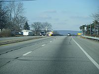
Pennsylvania Route 61 is an 81.14 mi (130.58 km)-long state highway
in the U.S. state
of Pennsylvania
. The route is signed on a north–south direction, from U.S. Route 222 Business
in Reading
to U.S. Route 11 and U.S. Route 15 in Shamokin Dam
. PA 61 meets up with Pennsylvania Route 54
in Ashland
and these highways split just outside of Ashland. PA 54 goes towards Mount Carmel
and PA 61 heads towards Centralia
.
PA 61 was assigned in 1963, comprising the section of the decommissioned U.S. Route 122 from Sunbury
to Reading
.
. The first three blocks of Centre Avenue are restricted to northbound travel, forcing PA 61 southbound to take the southbound-only North Fourth Street to Greenwich Street to access US 222 Business. At Fourth Street, Centre Avenue becomes bi-directional, allowing the city street to carry both directions of PA 61. The road continues northward through the city, paralleling the Schuylkill River
for a short distance prior to interchanging with Pennsylvania Route 12
, the Warren Street Bypass
, on the northern edge of Reading.
In the inner ring of suburb
s surrounding Reading, PA 61 becomes the Pottsville Pike in Muhlenberg Township
roughly two miles south of an interchange with U.S. Route 222 on the bank of the Schuylkill. On the opposite side of US 222, the surrounding of PA 61 changes rapidly, transitioning from tightly-packed suburbs to scattered communities. Near Leesport
, three miles (5 km) from US 222, PA 61 meets the western terminus of Pennsylvania Route 73
. The route then passes through Leesport and begins to parallel the Schuylkill once more.
 At Shoemakersville
, the now-four lane, divided highway
PA 61 breaks from the river and runs along the eastern edge of the borough, intersecting the northern terminus of Pennsylvania Route 662
near the center of town. In Hamburg
, PA 61 and the Schuylkill River meet once more, with the Schuylkill passing under PA 61 just southwest of an overpass crossing the former routing of U.S. Route 22 into Hamburg. PA 61, which skirts the western edge of the borough, meets the current routing of US 22, concurrent
here with Interstate 78, at a near-complete cloverleaf interchange
due west of town.
North of I-78 and US 22, PA 61 takes a notably northwest routing as it passes over the Schuylkill again and enters the appropriately named Schuylkill County
.
as it enters the small community of Port Clinton
. Here, PA 61 separates from the Schuylkill once more as the river heads west from the borough while PA 61 follows the Little Schuylkill River
north out of town. A mile from the northern edge of the borough, PA 61 passes over the Little Schuylkill, bringing about the northern terminus of Blue Mountain.
Past the mountain and its surrounding hills, PA 61 heads northwest and, eventually, due west through moderately level terrain, intersecting Pennsylvania Route 895
and running concurrent with the route near Deer Lake
in West Brunswick Township
before passing south of Orwigsburg
on a bypass. Through West Brunswick Township and North Manheim Township Route 61 is named Center Turnpike. Southwest of Orwigsburg, PA 61 intersects Pennsylvania Route 443
, the main road through Orwigsburg. The two routes join westward to the borough of Schuylkill Haven
, a short distance east of Cressona
. Through the borough it is called Center Avenue. At Dock Street, PA 443 splits from PA 61, heading south into the heart of the community while PA 61 turns north and follows the now-split Schuylkill River into a valley straddling Second Mountain and Sharp Mountain.
Immediately after passing the northern edge of Sharp Mountain, PA 61 enters Pottsville
, the largest community along PA 61 since its start in Reading. Just south of the city center, PA 61 intersects U.S. Route 209 at Mauch Chunk Street. North of US 209, PA 61, now named Claude A. Lord Boulevard, snakes through the heart of the community, passing along rows of houses and streets before entering a brief stretch of isolated land between Pottsville and neighboring St. Clair
in Norwegian Township. Upon passing into St. Clair, PA 61, which used to enter St. Clair directly via West Russel Street and Second Street, bypasses the borough to the immediate west, merging with North Second Street north of St. Clair. Through St. Clair PA 61 is named Joseph H. Long Boulevard.
From St. Clair north, PA 61 follows the routing of Mill Creek through a series of hills and mountains, snaking along the river valley as it progresses onward. Through New Castle Township and briefly in Blythe Township it is named Skyline Drive. Roughly 1.5 miles (2.4 km) from St. Clair, the route becomes a divided highway once more, retaining this status to an interchange with Interstate 81 south of Frackville
. No longer in a river valley surrounded by hills, PA 61 enters the borough on South Lehigh Avenue, meeting the southern terminus of Pennsylvania Route 924
in the center. At PA 924, PA 61 turns west onto West Oak Street, following the road as it runs through the densely-populated community and into Butler Township
.
 Outside of Frackville, PA 61 passes through a relatively rural area, bypassing the Ashland Reservoir to the north and Ashland Mountain to the south, heading toward the community of Fountain Springs
the entire way. West of Fountain Springs, PA 61 begins to turn northward once more and enters Ashland
as it returns to a due north alignment.
As South Hoffman Boulevard, PA 61 passes over Mahanoy Creek
prior to entering the heart of the borough. Five blocks north of the waterway, PA 61 meets Pennsylvania Route 54
near the eastern edge of town. PA 61 turns west onto Centre Street, joining with PA 54 through Ashland. Near the western border of the borough, PA 61 turns north onto North Memorial Boulevard, breaking from PA 54 and proceeding into Columbia County
.
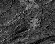
, are visible to the south of the road. Continuing northward, the road reconnects with the old alignment of PA 61 a short distance south of Centralia
.
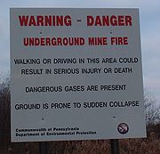 As in Byrnesville to the south, an underground mine fire has crippled Centralia, reducing its population to only 10 as of 2010. Signs of the town's past are evident all along PA 61, from streets and sidewalks leading away from PA 61 but seemingly heading nowhere to empty lots located throughout the town. In the center of the borough, PA 61 meets the southern terminus of Pennsylvania Route 42
at the junction of Locust Avenue and Centre Street. While PA 42 continues north on Locust Avenue, PA 61 turns west onto Centre Street, passing two all-but-barren streets before quietly exiting Centralia.
 2.5 miles (4 km) to the west, PA 61's brief stay in Columbia County comes to an end as the route enters Northumberland County
.
on East Fifth Street. The route heads into the heart of the large community, turning north on Market Street before resuming its westward track on East Avenue, West Avenue and Poplar Street, the latter of which leads PA 61 out of Mount Carmel to the northeast. One mile from the borough, PA 61 meets PA 54 for the second time.
West of Mount Carmel in Coal Township
, PA 61 meets the western terminus of Pennsylvania Route 901
via a rare rural interchange east of Shamokin
. In Shamokin, the largest city on the route since Pottsville, PA 61 meets the northern terminus of both Pennsylvania Route 125
and Pennsylvania Route 225
. North of the city in the township of the same name
, PA 61, a four-lane highway once more, meets the southern terminus of Pennsylvania Route 487
.
Ten miles west of PA 487, the amount of development along PA 61 increases exponentially, transitioning from rural hills and land east of the Upper Augusta Township
community of Oaklyn to densely-packed villages only one mile to the west in Hamilton, where PA 61 meets Pennsylvania Route 890
. Through Oaklyn and Hamilton PA 61 is called State Street. The increase in development continues as PA 61 enters the city of Sunbury
at Market Street and forms a concurrency with Pennsylvania Route 147
southward along the bank of the Susquehanna River
at South Front Street. After three-quarters of a mile, the two routes split via a modified trumpet interchange, allowing PA 61 to access a bridge crossing the Susquehanna and terminate at an interchange with U.S. Route 11 and U.S. Route 15 in Shamokin Dam
, Snyder County
.
in Shamokin Dam
to U.S. Route 22 in Reading. In 1935, US 120 was truncated to terminate at U.S. Route 220
in Lock Haven
. The modern routing of PA 61 was then redesignated as part of U.S. Route 122 from U.S. Route 15 in Sunbury to U.S. Route 222 in Reading. US 122 continued south to Oxford; it was first truncated to Morgantown in 1956, and then removed entirely in 1963; the part south of Reading became Pennsylvania Route 10
while the remainder of former US 122 became PA 61.
By 1950, the roadway around Centralia was widened to 4 lanes. Also, U.S. Route 15
was moved along the westside of the Susquehanna River
, and Pennsylvania Route 14
was routed along what is now PA 147.
 Because of the coal mine fire in Centralia
, the original branch of Routes 54 and 61, which went from Centralia to Ashland, has been permanently closed because the road has severely opened up and buckled extensively. This branch was repaired in 1983 for $500,000; then in 1992 it was deemed too expensive to repair again. In 1994, the branch was permanently closed, and as of result, graffiti
were scattered along the closed portion of the roadway. In 1999, Byrnesville Road (Quadrant Route 2002), located directly south of the closed section of PA 61, was upgraded and now carries PA 61, bypassing the section of PA 61 which was damaged by the underground mine fire in Centralia.
PA 54 formerly ran concurrent
with PA 61 through Centralia but was rerouted along Pennsylvania Route 901
and three quadrant routes in 1999, completely bypassing Centralia. Nowadays, only PA 61 goes through Centralia while PA 54 now goes directly from Ashland to Mount Carmel along the aforementioned alignment via PA 901. The road signs for PA 54 were removed from Centralia several years ago.
Routes 54 and 61 meet up again at an intersection just outside of Mount Carmel.

. Together, they help larger vehicles avoid a narrow plaza area and a tight intersection with Pennsylvania Route 147
. The one-mile designation of the loop along Chestnut Street, which travels two blocks to the south of the main route through the city center, funnels traffic that is continuing along Route 61 or that needs to access Route 147 southbound. A similar route branches off of the mainline at 5th Street and travels two blocks to the north along Arch Street to reach Route 147 northbound.
State highway
State highway, state road or state route can refer to one of three related concepts, two of them related to a state or provincial government in a country that is divided into states or provinces :#A...
in the U.S. state
U.S. state
A U.S. state is any one of the 50 federated states of the United States of America that share sovereignty with the federal government. Because of this shared sovereignty, an American is a citizen both of the federal entity and of his or her state of domicile. Four states use the official title of...
of Pennsylvania
Pennsylvania
The Commonwealth of Pennsylvania is a U.S. state that is located in the Northeastern and Mid-Atlantic regions of the United States. The state borders Delaware and Maryland to the south, West Virginia to the southwest, Ohio to the west, New York and Ontario, Canada, to the north, and New Jersey to...
. The route is signed on a north–south direction, from U.S. Route 222 Business
U.S. Route 222 Business (Reading, Pennsylvania)
U.S. Route 222 Business is an auxiliary route of U.S. Route 222 located in Reading, Pennsylvania. Its northern terminus is at US 222 north of Laureldale. The southern terminus is at US 222 near Mohnton. US 222 Business is the only auxiliary route of U.S. Route 222 in Pennsylvania.- Route...
in Reading
Reading, Pennsylvania
Reading is a city in southeastern Pennsylvania, USA, and seat of Berks County. Reading is the principal city of the Greater Reading Area and had a population of 88,082 as of the 2010 census, making it the fifth most populated city in the state after Philadelphia, Pittsburgh, Allentown and Erie,...
to U.S. Route 11 and U.S. Route 15 in Shamokin Dam
Shamokin Dam, Pennsylvania
Shamokin Dam is a small borough in Snyder County, Pennsylvania, United States. The name is derived from a dam that was built across the Susquehanna River in the 19th century. The dam supported steamboat ferries run by Ira T. Clement, which transported goods and people between Shamokin Dam and the...
. PA 61 meets up with Pennsylvania Route 54
Pennsylvania Route 54
Pennsylvania Route 54 is a state highway which runs for in eastern Pennsylvania. It runs from U.S. Route 209 in Nesquehoning, Carbon County in the east to U.S. Route 15, which is three miles west of Montgomery, Lycoming County in the west...
in Ashland
Ashland, Pennsylvania
Ashland is a borough in Schuylkill county in the U.S. state of Pennsylvania, 12 miles northwest of Pottsville. The Borough lies in the anthracite coal region of eastern Pennsylvania. Settled in 1850, Ashland was incorporated in 1857, and was named for Henry Clay's estate near Lexington, Kentucky....
and these highways split just outside of Ashland. PA 54 goes towards Mount Carmel
Mount Carmel, Pennsylvania
Mount Carmel is the name of a borough in Northumberland County, Pennsylvania, United States. The population was 6390 at the 2000 census. It is located 88 miles northwest of Philadelphia and 71 miles northeast of Harrisburg, in the Anthracite Coal Region...
and PA 61 heads towards Centralia
Centralia, Pennsylvania
Centralia is a borough and ghost town in Columbia County, Pennsylvania, United States. Its population has dwindled from over 1,000 residents in 1981 to 12 in 2005, 9 in 2007, and 10 in 2010, as a result of a mine fire burning beneath the borough since 1962...
.
PA 61 was assigned in 1963, comprising the section of the decommissioned U.S. Route 122 from Sunbury
Sunbury, Pennsylvania
Sunbury is a city in Northumberland County, Pennsylvania, United States. The city is located on the east bank of the Susquehanna River, just downstream of the confluence of its main and West branches. The population was 9,905 at the 2010 census...
to Reading
Reading, Pennsylvania
Reading is a city in southeastern Pennsylvania, USA, and seat of Berks County. Reading is the principal city of the Greater Reading Area and had a population of 88,082 as of the 2010 census, making it the fifth most populated city in the state after Philadelphia, Pittsburgh, Allentown and Erie,...
.
Berks County
PA 61 begins at the intersection of Centre Avenue and North Fifth Street (US 222 Business) in downtown Reading, Berks CountyBerks County, Pennsylvania
-Demographics:As of the census of 2000, there were 373,638 people, 141,570 households, and 98,532 families residing in the county. The population density was 435 people per square mile . There were 150,222 housing units at an average density of 175 per square mile...
. The first three blocks of Centre Avenue are restricted to northbound travel, forcing PA 61 southbound to take the southbound-only North Fourth Street to Greenwich Street to access US 222 Business. At Fourth Street, Centre Avenue becomes bi-directional, allowing the city street to carry both directions of PA 61. The road continues northward through the city, paralleling the Schuylkill River
Schuylkill River
The Schuylkill River is a river in Pennsylvania. It is a designated Pennsylvania Scenic River.The river is about long. Its watershed of about lies entirely within the state of Pennsylvania. The source of its eastern branch is in the Appalachian Mountains at Tuscarora Springs, near Tamaqua in...
for a short distance prior to interchanging with Pennsylvania Route 12
Pennsylvania Route 12
Pennsylvania Route 12 is a long part-freeway located in eastern Pennsylvania. The western terminus of the route is at U.S. Route 422 and U.S. Route 222 near Reading. Its eastern terminus is Pennsylvania Route 662 in Ruscombmanor Township. In Reading, the freeway is named the Warren Street Bypass...
, the Warren Street Bypass
Warren Street Bypass
The Warren Street Bypass is a limited access road in Berks County, Pennsylvania, carrying Pennsylvania Route 12, U.S. Route 222 and U.S. Route 422. The eastern terminus of the bypass is at Hyde Park, where the road returns to grade level as PA 12. The western terminus is at the US 222/US 422 split...
, on the northern edge of Reading.
In the inner ring of suburb
Suburb
The word suburb mostly refers to a residential area, either existing as part of a city or as a separate residential community within commuting distance of a city . Some suburbs have a degree of administrative autonomy, and most have lower population density than inner city neighborhoods...
s surrounding Reading, PA 61 becomes the Pottsville Pike in Muhlenberg Township
Muhlenberg Township, Pennsylvania
Muhlenberg Township is a township in Berks County, Pennsylvania, United States. The population was 16,305 at the 2000 census.-Geography:According to the United States Census Bureau, the township has a total area of 12.2 square miles , of which, 12.0 square miles of it is land and...
roughly two miles south of an interchange with U.S. Route 222 on the bank of the Schuylkill. On the opposite side of US 222, the surrounding of PA 61 changes rapidly, transitioning from tightly-packed suburbs to scattered communities. Near Leesport
Leesport, Pennsylvania
Leesport is a borough in Berks County, Pennsylvania, United States. The population was 1,805 at the 2000 census.-Geography:Leesport is located at ....
, three miles (5 km) from US 222, PA 61 meets the western terminus of Pennsylvania Route 73
Pennsylvania Route 73
Pennsylvania Route 73 is a 62.51 miles long east–west state highway in southeastern Pennsylvania. It runs from Pennsylvania Route 61 in Leesport to the New Jersey state line on the Tacony-Palmyra Bridge in Philadelphia, where it continues as New Jersey Route 73.Predating the Interstate...
. The route then passes through Leesport and begins to parallel the Schuylkill once more.
Shoemakersville, Pennsylvania
Shoemakersville is a borough in Berks County, Pennsylvania, United States. The population was 2,124 at the 2000 census.-Overview:Shoemakersville was named for the first settlers Henry and Charles Shoemaker. It was a thriving apparel manufacturing town. It is home of the "The Shoey Green Sox" the...
, the now-four lane, divided highway
Divided Highway
Divided Highway is a compilation album by American rock band The Doobie Brothers, released in 2003. . All tracks are taken from the albums Cycles and Brotherhood .-Track listing:...
PA 61 breaks from the river and runs along the eastern edge of the borough, intersecting the northern terminus of Pennsylvania Route 662
Pennsylvania Route 662
Pennsylvania Route 662 is a long road located in eastern Pennsylvania. Its northern terminus is at Pennsylvania Route 61 in Shoemakerville and its southern terminus is at U.S. Route 422 in Douglassville. The entire route is in Berks County...
near the center of town. In Hamburg
Hamburg, Pennsylvania
Hamburg is a borough in Berks County, Pennsylvania, United States. The population was 4,114 at the 2000 census. The town is named after Hamburg, Germany.-Geography:Hamburg is located at ....
, PA 61 and the Schuylkill River meet once more, with the Schuylkill passing under PA 61 just southwest of an overpass crossing the former routing of U.S. Route 22 into Hamburg. PA 61, which skirts the western edge of the borough, meets the current routing of US 22, concurrent
Concurrency (road)
A concurrency, overlap, or coincidence in a road network is an instance of one physical road bearing two or more different highway, motorway, or other route numbers...
here with Interstate 78, at a near-complete cloverleaf interchange
Cloverleaf interchange
A cloverleaf interchange is a two-level interchange in which left turns, reverse direction in left-driving regions, are handled by ramp roads...
due west of town.
North of I-78 and US 22, PA 61 takes a notably northwest routing as it passes over the Schuylkill again and enters the appropriately named Schuylkill County
Schuylkill County, Pennsylvania
-Notable people:*Boxing heavyweight great Muhammad Ali had his training camp in Deer Lake.*Charles Justin Bailey, commanding general of the 81st Division in World War I, was born in Tamaqua on June 21, 1859....
.
Schuylkill County
On the opposite bank of the Schuylkill, PA 61, now carrying the name Center Street, runs along the western foot of the Blue MountainBlue Mountain (Pennsylvania)
Blue Mountain is a ridge that forms the eastern edge of the Appalachian mountain range in the U.S. state of Pennsylvania. It cuts across the eastern half of the state from New Jersey to Maryland, providing a distinct boundary between a number of Pennsylvania's geographical and cultural regions...
as it enters the small community of Port Clinton
Port Clinton, Pennsylvania
Port Clinton is a borough in Schuylkill County, Pennsylvania, United States. The population was 288 at the 2000 census.-Geography:Port Clinton is located at ....
. Here, PA 61 separates from the Schuylkill once more as the river heads west from the borough while PA 61 follows the Little Schuylkill River
Little Schuylkill River
Little Schuylkill River is a tributary of the Schuylkill River in northeast Pennsylvania in the United States.It rises south of McAdoo Heights in Schuylkill County, Pennsylvania, on top of Broad Mountain. It flows south, then southwest passing through the communities of Tamaqua and New Ringgold....
north out of town. A mile from the northern edge of the borough, PA 61 passes over the Little Schuylkill, bringing about the northern terminus of Blue Mountain.
Past the mountain and its surrounding hills, PA 61 heads northwest and, eventually, due west through moderately level terrain, intersecting Pennsylvania Route 895
Pennsylvania Route 895
Pennsylvania Route 895 is a state highway in the U.S. state of Pennsylvania. It is designated as an east–west route, with termini at Route 443 in Pine Grove and Route 248 in Bowmanstown. The entire course is close to the north flank of Blue Mountain.- Schuylkill County :PA 895 begins at an...
and running concurrent with the route near Deer Lake
Deer Lake, Pennsylvania
Deer Lake is a borough in Schuylkill County, Pennsylvania, United States. The population was 528 at the 2000 census. The mayor of the borough is Michael Cooper.http://www.deerlakeborough.org-History:...
in West Brunswick Township
West Brunswick Township, Pennsylvania
West Brunswick Township is a township in Schuylkill County, Pennsylvania, United States. Brunswick Township was formed in 1801 as one of the original townships of Schuylkill County, being named for Brunswick , Germany. In 1835, Brunswick Township was divided into East and West Brunswick Townships...
before passing south of Orwigsburg
Orwigsburg, Pennsylvania
Orwigsburg is a borough in Schuylkill County, Pennsylvania, United States. Named for its founder, Peter Orwig, from West Brunswick Township in 1823. The population was 3,106 at the 2000 census...
on a bypass. Through West Brunswick Township and North Manheim Township Route 61 is named Center Turnpike. Southwest of Orwigsburg, PA 61 intersects Pennsylvania Route 443
Pennsylvania Route 443
Pennsylvania Route 443 is a long east–west state highway in the US state of Pennsylvania. Unlike other state highways, PA 443 terminates at not a traffic route at its west end, but at Front Street, formerly U.S. Route 22 and U.S. Route 322 and presently Quadrant Route 3009, in the...
, the main road through Orwigsburg. The two routes join westward to the borough of Schuylkill Haven
Schuylkill Haven, Pennsylvania
Schuylkill Haven is a borough in Schuylkill County, Pennsylvania, four miles south of Pottsville and north-west of Philadelphia, in the United States. The borough's population was 5,548 as of the 2000 census. Schuylkill Haven is situated along the Schuylkill River for which it is named...
, a short distance east of Cressona
Cressona, Pennsylvania
Cressona is a borough in Schuylkill County, Pennsylvania, United States. Formed in 1857 from part of North Manheim Township, it was founded by and named for John Chapman Cresson, a Philadelphia civil engineer and manager of the Schuylkill Navigation Company, President of the Mine Hill and...
. Through the borough it is called Center Avenue. At Dock Street, PA 443 splits from PA 61, heading south into the heart of the community while PA 61 turns north and follows the now-split Schuylkill River into a valley straddling Second Mountain and Sharp Mountain.
Immediately after passing the northern edge of Sharp Mountain, PA 61 enters Pottsville
Pottsville, Pennsylvania
Pottsville is the only city in and the county seat of Schuylkill County, Pennsylvania, United States. The population was 15,549 at the 2000 census. The city lies along the west bank of the Schuylkill River, north-west of Philadelphia...
, the largest community along PA 61 since its start in Reading. Just south of the city center, PA 61 intersects U.S. Route 209 at Mauch Chunk Street. North of US 209, PA 61, now named Claude A. Lord Boulevard, snakes through the heart of the community, passing along rows of houses and streets before entering a brief stretch of isolated land between Pottsville and neighboring St. Clair
St. Clair, Pennsylvania
St. Clair is a borough in Schuylkill County, Pennsylvania two miles north of Pottsville or the southern Coal Region. Extensive deposits of hard coal are present...
in Norwegian Township. Upon passing into St. Clair, PA 61, which used to enter St. Clair directly via West Russel Street and Second Street, bypasses the borough to the immediate west, merging with North Second Street north of St. Clair. Through St. Clair PA 61 is named Joseph H. Long Boulevard.
From St. Clair north, PA 61 follows the routing of Mill Creek through a series of hills and mountains, snaking along the river valley as it progresses onward. Through New Castle Township and briefly in Blythe Township it is named Skyline Drive. Roughly 1.5 miles (2.4 km) from St. Clair, the route becomes a divided highway once more, retaining this status to an interchange with Interstate 81 south of Frackville
Frackville, Pennsylvania
Frackville is a borough in Schuylkill County, Pennsylvania. Frackville is located near the intersection of Interstate 81 and Pennsylvania State Route 61, approximately northeast of Harrisburg and southwest of Wilkes-Barre.-History:...
. No longer in a river valley surrounded by hills, PA 61 enters the borough on South Lehigh Avenue, meeting the southern terminus of Pennsylvania Route 924
Pennsylvania Route 924
Pennsylvania Route 924 is a long state highway in the U.S. state of Pennsylvania. The highway runs from Pennsylvania Route 61 in Frackville to Pennsylvania Route 309 in Hazleton.-Route description:...
in the center. At PA 924, PA 61 turns west onto West Oak Street, following the road as it runs through the densely-populated community and into Butler Township
Butler Township, Schuylkill County, Pennsylvania
Butler Township is a township in Schuylkill County, Pennsylvania, United States. Formed in 1848 from part of Barry Township, it is named for war hero William Orlando Butler.-Geography:...
.
Fountain Springs, Pennsylvania
Fountain Springs is a census-designated place in Schuylkill County, Pennsylvania, United States. The population was 100 at the 2000 census.-Geography:Fountain Springs is located at ....
the entire way. West of Fountain Springs, PA 61 begins to turn northward once more and enters Ashland
Ashland, Pennsylvania
Ashland is a borough in Schuylkill county in the U.S. state of Pennsylvania, 12 miles northwest of Pottsville. The Borough lies in the anthracite coal region of eastern Pennsylvania. Settled in 1850, Ashland was incorporated in 1857, and was named for Henry Clay's estate near Lexington, Kentucky....
as it returns to a due north alignment.
As South Hoffman Boulevard, PA 61 passes over Mahanoy Creek
Mahanoy Creek
Mahanoy Creek, known locally as Coal Creek, is a tributary of the Susquehanna River in the Coal Region of east-central Pennsylvania in the United States....
prior to entering the heart of the borough. Five blocks north of the waterway, PA 61 meets Pennsylvania Route 54
Pennsylvania Route 54
Pennsylvania Route 54 is a state highway which runs for in eastern Pennsylvania. It runs from U.S. Route 209 in Nesquehoning, Carbon County in the east to U.S. Route 15, which is three miles west of Montgomery, Lycoming County in the west...
near the eastern edge of town. PA 61 turns west onto Centre Street, joining with PA 54 through Ashland. Near the western border of the borough, PA 61 turns north onto North Memorial Boulevard, breaking from PA 54 and proceeding into Columbia County
Columbia County, Pennsylvania
As of the census of 2000, there were 64,151 people, 24,915 households, and 16,568 families residing in the county. The population density was 132 people per square mile . There were 27,733 housing units at an average density of 57 per square mile...
.
Columbia County
After crossing over the county line, PA 61 begins to curve to the northeast as it passes through a heavily rural area of eastern central Pennsylvania. Approximately three-quarters of a mile from the county line, a sharp turn deposits the four-lane PA 61 onto Byrnesville Road, a narrow two-lane road upgraded by PennDOT following the closure of a severely damaged mile-long stretch of PA 61 in 1994. After three-quarters of a mile, a clearing and an old unmaintained street, once known as ByrnesvilleByrnesville, Pennsylvania
Byrnesville was a town located in Conyngham Township, Columbia County, Pennsylvania, United States. It was located about halfway between Centralia and Ashland. A map with GPS coordinates can be seen . In 1985, the population of Byrnesville was approximately 75.Byrnesville was founded in 1856. Most...
, are visible to the south of the road. Continuing northward, the road reconnects with the old alignment of PA 61 a short distance south of Centralia
Centralia, Pennsylvania
Centralia is a borough and ghost town in Columbia County, Pennsylvania, United States. Its population has dwindled from over 1,000 residents in 1981 to 12 in 2005, 9 in 2007, and 10 in 2010, as a result of a mine fire burning beneath the borough since 1962...
.
Pennsylvania Route 42
Pennsylvania Route 42 is a long state route located in central Pennsylvania. The southern terminus of the route is at Pennsylvania Route 61 in Centralia. The northern terminus is at U.S. Route 220 in Laporte. In Beech Glen, Sullivan County, it concurs with U.S. 220, loops through Eagles Mere and...
at the junction of Locust Avenue and Centre Street. While PA 42 continues north on Locust Avenue, PA 61 turns west onto Centre Street, passing two all-but-barren streets before quietly exiting Centralia.
Northumberland County, Pennsylvania
There were 38,835 households out of which 27.30% had children under the age of 18 living with them, 52.40% were married couples living together, 9.60% had a female householder with no husband present, and 34.10% were non-families. 30.20% of all households were made up of individuals and 15.50% had...
.
Northumberland and Snyder Counties
A short distance west of the county line, PA 61 enters Mount CarmelMount Carmel, Pennsylvania
Mount Carmel is the name of a borough in Northumberland County, Pennsylvania, United States. The population was 6390 at the 2000 census. It is located 88 miles northwest of Philadelphia and 71 miles northeast of Harrisburg, in the Anthracite Coal Region...
on East Fifth Street. The route heads into the heart of the large community, turning north on Market Street before resuming its westward track on East Avenue, West Avenue and Poplar Street, the latter of which leads PA 61 out of Mount Carmel to the northeast. One mile from the borough, PA 61 meets PA 54 for the second time.
West of Mount Carmel in Coal Township
Coal Township, Pennsylvania
Coal Township is a township in Northumberland County, Pennsylvania, United States. The population was 10,628 at the 2000 census.-Geography:According to the United States Census Bureau, the township has a total area of , of which, of it is land and of it is water.-Demographics:As of the census of...
, PA 61 meets the western terminus of Pennsylvania Route 901
Pennsylvania Route 901
Pennsylvania Route 901 is a long state route located in eastern Pennsylvania. The western terminus of the route is at Pennsylvania Route 61 in the Coal Township hamlet of Ranshaw. Its eastern terminus is at Pennsylvania Route 183 in Cressona....
via a rare rural interchange east of Shamokin
Shamokin, Pennsylvania
Shamokin is a city in Northumberland County, Pennsylvania, at the western edge of the Anthracite Coal Region. At the 2000 census the population was 8,009 residents...
. In Shamokin, the largest city on the route since Pottsville, PA 61 meets the northern terminus of both Pennsylvania Route 125
Pennsylvania Route 125
Pennsylvania Route 125 is a long state highway located in Schuylkill and Northumberland counties in Pennsylvania. The southern terminus is at PA 443 in Pine Grove. The northern terminus is at PA 61 in Shamokin...
and Pennsylvania Route 225
Pennsylvania Route 225
Pennsylvania Route 225 is an long state highway located in Dauphin and Northumberland counties in Pennsylvania. The southern terminus is at US 22/US 322 in Dauphin...
. North of the city in the township of the same name
Shamokin Township, Pennsylvania
Shamokin Township is a township in Northumberland County, Pennsylvania, United States. The population was 2,159 at the 2000 census.The city of Shamokin does not sit within the boundaries of Shamokin Township...
, PA 61, a four-lane highway once more, meets the southern terminus of Pennsylvania Route 487
Pennsylvania Route 487
Pennsylvania Route 487 is a long, north–south state highway running from PA 61 in Shamokin Township, Northumberland County to PA 87 in Dushore, Sullivan County. In Bloomsburg, PA 487 and US 11 share a brief wrong-way concurrency...
.
Ten miles west of PA 487, the amount of development along PA 61 increases exponentially, transitioning from rural hills and land east of the Upper Augusta Township
Upper Augusta Township, Pennsylvania
Upper Augusta Township is a township in Northumberland County, Pennsylvania, United States. It was formed in 1846 by the division of Augusta Township into Upper and Lower sections...
community of Oaklyn to densely-packed villages only one mile to the west in Hamilton, where PA 61 meets Pennsylvania Route 890
Pennsylvania Route 890
Pennsylvania Route 890 is a long state highway located in Northumberland county in Pennsylvania. The southern terminus is at PA 225 in Zerbe Township...
. Through Oaklyn and Hamilton PA 61 is called State Street. The increase in development continues as PA 61 enters the city of Sunbury
Sunbury, Pennsylvania
Sunbury is a city in Northumberland County, Pennsylvania, United States. The city is located on the east bank of the Susquehanna River, just downstream of the confluence of its main and West branches. The population was 9,905 at the 2010 census...
at Market Street and forms a concurrency with Pennsylvania Route 147
Pennsylvania Route 147
Pennsylvania Route 147 is a north–south route that runs for along the east shore of the Susquehanna River in central Pennsylvania, United States. The northern terminus is at an interchange with Interstate 80 and Interstate 180 in Turbot Township. The southern terminus is at an interchange...
southward along the bank of the Susquehanna River
Susquehanna River
The Susquehanna River is a river located in the northeastern United States. At long, it is the longest river on the American east coast that drains into the Atlantic Ocean, and with its watershed it is the 16th largest river in the United States, and the longest river in the continental United...
at South Front Street. After three-quarters of a mile, the two routes split via a modified trumpet interchange, allowing PA 61 to access a bridge crossing the Susquehanna and terminate at an interchange with U.S. Route 11 and U.S. Route 15 in Shamokin Dam
Shamokin Dam, Pennsylvania
Shamokin Dam is a small borough in Snyder County, Pennsylvania, United States. The name is derived from a dam that was built across the Susquehanna River in the 19th century. The dam supported steamboat ferries run by Ira T. Clement, which transported goods and people between Shamokin Dam and the...
, Snyder County
Snyder County, Pennsylvania
Snyder County is a county located in the U.S. state of Pennsylvania. As of 2010, the population was 39,702. Snyder County was formed in 1855 from parts of Union County...
.
U.S. Routes 120 and 122
In 1926, what is now PA 61 became part of U.S. Route 120, from US Routes 11 and 111U.S. Route 111
U.S. Route 111 was a U.S. Route that ran from Baltimore, Maryland north to the Harrisburg, Pennsylvania area. It replaced part of the Susquehanna Trail and was in turn replaced by Interstate 83. Portions of its pre-freeway alignment are now Maryland Route 45 and Interstate 83 Business...
in Shamokin Dam
Shamokin Dam, Pennsylvania
Shamokin Dam is a small borough in Snyder County, Pennsylvania, United States. The name is derived from a dam that was built across the Susquehanna River in the 19th century. The dam supported steamboat ferries run by Ira T. Clement, which transported goods and people between Shamokin Dam and the...
to U.S. Route 22 in Reading. In 1935, US 120 was truncated to terminate at U.S. Route 220
U.S. Route 220
U.S. Route 220 is a long U.S. Route in the eastern United States.US 220 is a spur route of U.S. Route 20 but at present, the two routes do not intersect nor do they connect via other spurs of US 20. The former U. S. Route 120, which was signed in Pennsylvania between 1926 and 1967, intersected...
in Lock Haven
Lock Haven, Pennsylvania
The city of Lock Haven is the county seat of Clinton County, in the U.S. state of Pennsylvania. Located near the confluence of the West Branch Susquehanna River and Bald Eagle Creek, it is the principal city of the Lock Haven, Pennsylvania, micropolitan statistical area, itself part of the...
. The modern routing of PA 61 was then redesignated as part of U.S. Route 122 from U.S. Route 15 in Sunbury to U.S. Route 222 in Reading. US 122 continued south to Oxford; it was first truncated to Morgantown in 1956, and then removed entirely in 1963; the part south of Reading became Pennsylvania Route 10
Pennsylvania Route 10
Pennsylvania Route 10 is a long state route in southeastern Pennsylvania. PA 10 runs parallel to Interstate 176 for less than near Morgantown. Its southern terminus is at Pennsylvania Route 472 in Oxford. Its northern terminus is at U.S...
while the remainder of former US 122 became PA 61.
By 1950, the roadway around Centralia was widened to 4 lanes. Also, U.S. Route 15
U.S. Route 15
U.S. Route 15 is a -long United States highway, designated along South Carolina, North Carolina, Virginia, Maryland, Pennsylvania, and New York. The route is signed north–south, from U.S. Route 17 Alternate in Walterboro, South Carolina to Interstate 86 and NY 17 in Painted Post, New York.US...
was moved along the westside of the Susquehanna River
Susquehanna River
The Susquehanna River is a river located in the northeastern United States. At long, it is the longest river on the American east coast that drains into the Atlantic Ocean, and with its watershed it is the 16th largest river in the United States, and the longest river in the continental United...
, and Pennsylvania Route 14
Pennsylvania Route 14
Pennsylvania Route 14 is a Pennsylvania highway that runs for . It runs from U.S. Route 15 in Trout Run, Pennsylvania to the New York-Pennsylvania border at Fassett, Pennsylvania, co-signed with U.S. Route 6 for a short distance in Troy...
was routed along what is now PA 147.
Centralia branch of PA 54/61
Centralia, Pennsylvania
Centralia is a borough and ghost town in Columbia County, Pennsylvania, United States. Its population has dwindled from over 1,000 residents in 1981 to 12 in 2005, 9 in 2007, and 10 in 2010, as a result of a mine fire burning beneath the borough since 1962...
, the original branch of Routes 54 and 61, which went from Centralia to Ashland, has been permanently closed because the road has severely opened up and buckled extensively. This branch was repaired in 1983 for $500,000; then in 1992 it was deemed too expensive to repair again. In 1994, the branch was permanently closed, and as of result, graffiti
Graffiti
Graffiti is the name for images or lettering scratched, scrawled, painted or marked in any manner on property....
were scattered along the closed portion of the roadway. In 1999, Byrnesville Road (Quadrant Route 2002), located directly south of the closed section of PA 61, was upgraded and now carries PA 61, bypassing the section of PA 61 which was damaged by the underground mine fire in Centralia.
PA 54 formerly ran concurrent
Concurrency (road)
A concurrency, overlap, or coincidence in a road network is an instance of one physical road bearing two or more different highway, motorway, or other route numbers...
with PA 61 through Centralia but was rerouted along Pennsylvania Route 901
Pennsylvania Route 901
Pennsylvania Route 901 is a long state route located in eastern Pennsylvania. The western terminus of the route is at Pennsylvania Route 61 in the Coal Township hamlet of Ranshaw. Its eastern terminus is at Pennsylvania Route 183 in Cressona....
and three quadrant routes in 1999, completely bypassing Centralia. Nowadays, only PA 61 goes through Centralia while PA 54 now goes directly from Ashland to Mount Carmel along the aforementioned alignment via PA 901. The road signs for PA 54 were removed from Centralia several years ago.
Routes 54 and 61 meet up again at an intersection just outside of Mount Carmel.
Future
As part of the Central Susquehanna Valley Transportation Project, PA 61 is planned to continue westward from its current northern terminus, ending instead at a junction with a new limited-access roadway carrying U.S. Route 15. Instead of joining with 147 briefly in Sunbury, the two will run together from the southern end of the current duplex to the new northern terminus at US 15.Major intersections
PA 61 Truck
Pennsylvania Route 61 Truck is the name of two separate routes through Sunbury, PennsylvaniaSunbury, Pennsylvania
Sunbury is a city in Northumberland County, Pennsylvania, United States. The city is located on the east bank of the Susquehanna River, just downstream of the confluence of its main and West branches. The population was 9,905 at the 2010 census...
. Together, they help larger vehicles avoid a narrow plaza area and a tight intersection with Pennsylvania Route 147
Pennsylvania Route 147
Pennsylvania Route 147 is a north–south route that runs for along the east shore of the Susquehanna River in central Pennsylvania, United States. The northern terminus is at an interchange with Interstate 80 and Interstate 180 in Turbot Township. The southern terminus is at an interchange...
. The one-mile designation of the loop along Chestnut Street, which travels two blocks to the south of the main route through the city center, funnels traffic that is continuing along Route 61 or that needs to access Route 147 southbound. A similar route branches off of the mainline at 5th Street and travels two blocks to the north along Arch Street to reach Route 147 northbound.