

Jeffrey Street
Encyclopedia
Jeffrey Street or Jeffreys Street, Kirribilli
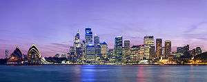
is famous as one of the most popular vantage points for views of the city of Sydney
, the Sydney Harbour Bridge
and the Sydney Opera House
. The street is on the Lower North Shore
of Sydney Harbour
immediately across the harbour from Circular Quay and is a popular destination for tourists, particularly on Australia Day
and New Year's Eve
. The street leads uphill from the harbour in a northerly direction to the small shopping village of Kirribilli.
The immediate vicinity of Jeffrey Street is reported to be the site of the first European settlement on the lower North Shore of Sydney Harbour. This happened within about 10 years following the colonisation of Australia
at Sydney Cove
in 1788. For many years the area was called the North Shore and the original land grant changed hands a number of times. Over the past 200 years the area has also been called Huntershill, St Leonards
, North Sydney
, "Kiarabilli", Milsons Point and "Kirribilli Point". The modern spelling Kirribilli was first used in about 1853 and the use of Kirribilli as a locality is more recent.
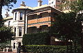
There are 19 heritage listed properties in the street, one of the highest concentrations of heritage listed properties in Australia.Exceeded only by Lower Fort Street in Millers Point at The Rocks
All but one of the original structures on the east side of the street have been demolished, only "Wyalla" remains. But the west side of Jeffrey Street is notable because it contains a row of 17 terrace houses that have remained virtually unchanged for over 100 years. This is the longest row remaining on Sydney's North Shore and the second longest row in Australia. Most of the other terrace houses in the area were demolished in order to construct the approaches to the Sydney Harbour Bridge.
North Sydney Council
favours the spelling of the street as "Jeffreys" as this correctly renders the surname of a 19th-century local landowner, Arthur Jeffreys. However, a Thomas Jeffrey was also a prominent early Kirribilli resident. Furthermore, some records report that a John Jeffreys was an early resident. Almost all historical references refer to Jeffrey Street so the provenance or derivation of the street name is uncertain.
North Sydney Council
is currently working through the planning approval process which if successful will lead to the establishment of the Jeffreys Street Heritage Conservation Area.
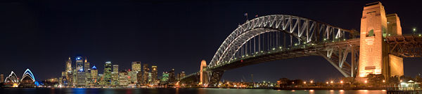 The view from Jeffrey Street is known to most Australians; indeed, it is well known internationally. The national Australian television station uses Jeffrey Street on an almost daily basis as their camera location or backdrop for the evening news bulletins. Thus, the view from Jeffrey Street is instantly recognisable to millions of people. Because Jeffrey Street is immediately across the harbour from the city, many Sydney-based professional photographers showcase photographs of the city that they have taken from the street.
The lookouts adjacent to Jeffrey Street are popular tourist destinations. The size of the crowds that often gather here to watch celebrations on the harbour now necessitates strong police and security presence.
Jeffrey Street is also a celebrated location for weddings and wedding photographs. Ted Mack
, at the time an Independent MP and formerly Mayor of North Sydney, was quoted as saying that it is one of the most important locations in Sydney.
” lived in the Kirribilli and Milson's Point area.
The area was a fertile fishing ground and the name “Kirribilli” is the Aboriginal word for "good fishing spot".
. One of the first records of land being granted on the "North Shore" was of 30 acres (121,405.8 m²) on the "North side of the Harbour of Port Jackson opposite Sydney Cove
" on 20 February 1794 to a convict
, Samuel Lightfoot, whose sentence had expired.The first land grants north of the harbour occurred on the 3rd January 1792 to eight marines. This occurred in the Ryde area along the northern bank of the river between Sydney and Parramatta. Grants were subsequently made in February 1792 to ten emancipated convicts (including John or Joseph Carter) at the Field of Mars further up the North Shore in the area of the modern suburb of Ryde.
Lightfoot was born in about 1763 and was in his mid-twenties when he was transported to Australia for seven years for stealing clothing. He arrived with the First Fleet
in 1788 on the Charlotte
. The Colonial Secretary records (NSW State Records) that the land grant was cancelled and given to Robert Ryan in 1800 with no mention of the intermediate sale to Muir.
After serving his sentence, Lightfoot did not stay in Kirribilli for long. He returned to England soon after his sentence expired and petitioned to be allowed to return with his wife, who however appears not to have sailed. Lightfoot subsequently returned to Australia on the HMS Calcutta
as a free settler, participating in the effort to establish a settlement at Port Phillip
, near the modern city of Melbourne
. When the settlement was abandoned, Lightfoot travelled on the Ocean
from Port Phillip, arriving in Tasmania
in 1804. Lieutenant-Governor David Collins
subsequently appointed Lightfoot supervisor of the hospital in Hobart Town
. Lightfoot died in 1818 aged 65.
There is no other known record of Lightfoot's time in Kirribilli.Research from the Information Request Service at the State Library of New South Wales, Reference question #: IR141101 on 29 June 2010 Nor is the exact location of the land grant known. The size of the grant of 30 acres (121,405.8 m²) corresponds to an area of approximately one quarter the area of the Kirribilli peninsula
but boundaries on early maps do not correspond to a grant of this size. The area of Jeffrey Street was probably the most attractive area (from an agricultural perspective), being a fertile alluvial area leading to a small beach near the current wharf at Jeffrey Street. Thomas Muir and James Milson subsequently farmed in this general vicinity, but whether their farms included the area of Lightfoot's grant is uncertain.
. Muir stated in letters that he purchased a "small hut and several acres of land", and accounts indicate that the land was located in the immediate vicinity of Jeffrey Street.
Muir's life is well documented in several books but there is little information about his home in on the North Shore of Sydney Harbour. The accounts vary:
The most descriptive modern account states "...the bay that is situated close under the eastern side of the present northen harbour bridge pylon. On the narrow alluvial flat beyond the beach was a small hut and close around Muir was to have his domestic gardens.*** " The original sources referenced in this book and indicated *** have not been cited. The only narrow alluvial flat in the area is the area between the modern day Jeffrey Street and Broughton Street close to the wharf.
Some sources allege that Muir purchased the land illegally. The reason for the allegation is that the Colonial Secretary's records have no record of the sale transaction; the record notes simply that the land grant passed from Lightfoot to Ryan. However, it is likely that Muir, who had studied law at Edinburgh University and had passed his bar examinations in 1787 at the age of 22, had arranged a private contract for the sale of the land. If so, this was almost certainly one of the first contracts for the sale of property in Australia.
Muir is recorded as having periodically lived in the area. He also owned a house at Sydney Cove
. In 1794 he wrote to a friend in London and said that he had two houses, one here (Sydney Cove
) and " another two miles distant, at a farm across the water, which I purchased".
Muir called the area "Huntershill" (not to be confused with the modern day suburb of "Hunters Hill
" further up the harbour). The spelling as a single word appears on a number of early maps and books.
Muir escaped Australia in 1796, aboard an American ship, the Otter
. A good account of his escape from the colony appears in several books and Pierre François Péron
chronicled Otters voyage across the Pacific. After Muir escaped, the government retracted the land grant and the land reverted to the government. Muir died in France
two years later.
, a 334 ton transport. Ryan established a relationship with Frances Williams, born circa 1760 in Wales
. Williams first appeared before the courts in 1783 in Mold Wales accused of stealing clothing and cloth valued at 1 pound 17 shillings and 5 pence. Frances was found guilty and sentenced to death. The sentence was later commuted to 7 years transportation
. Frances met Ryan on the Prince of Wales
on the voyage to Australia (a voyage of almost nine months).
Soon after the establishment of the settlement at Port Jackson
Frances gave birth to a daughter Sarah. It is known that early in 1790 the impending starvation at Sydney Cove led to the transportation
of convicts and marines to Norfolk Island
. Williams and Ryan arrived in Norfolk Island in March 1790 onboard the HMS Sirius
.
In January 1792 Robert Ryan was discharged from the marines and received a land grant of 60 acres (242,811.6 m²) located at Mount Pitt Valley, Queenborough Norfolk Island. Frances gave birth to daughter Jane In August 1793. Some sources state that Convict John Cropper is thought to be the father.
The 1794 victualling List for Norfolk Island
records Frances Williams and 2 children being supported by Robert Ryan. Later in 1794 Robert Ryan abandoned the land and returned to Sydney. He enlisted in the NSW Corps, later returning to Norfolk Island with a contingent of soldiers. In December 1796 a son James was born. No name for the father was given. After Robert Ryan left the Island records state that the Norfolk Island community cared for the children. The children eventually moved to Tasmania
.
Back in Sydney in 1800, the 30 acres (12 hectares) of Lightfoot's Grant was cancelled and included in a 120 acre (48.5-hectare) grant to Ryan for his service in the Royal Marines
and the NSW Corps. The corresponding entry in the Register of Land Grants states Cancelled, and a New Grant given to Robert Ryan for 90 acres in addition to this Allotment, by Governor Hunter. See the third Register, Folio 37. This grant surrounded what is now Jeffrey Street and later maps referred.
It is reported that Ryan knew nothing about farming so the land was sold to Robert Campbell
in about 1806. Other reliable accounts state that the land was sold to Charles Grimes
, the Surveyor General who then quickly on-sold to Campbell.
, the NSW Surveyor General are not known.
However, it is known that Grimes sold the land relatively quickly to John Palmer who was acting as the agent for Robert Campbell
in about 1806. Accounts indicate that Campbell identified the block of land and asked his agent to purchase it before leaving for England. The transaction had been completed by the time he returned.
The block of land included all of the Kirribilli peninsula. It included roughly all of the land between Lavender Bay and Careening Bay, with the northern boundary being where Willoughby Road runs today. Kirribilli Point, Admiralty House, Sydney
, Milsons Point and Luna Park, Sydney were all within its boundaries. It ran from Milson's Point for about 600 yeards inland. Campbell's main interest in the block of land was the gently sloping foreshores of Careening Bay. There are relatively few places on Sydney Harbour where there are gently sloping foreshores suitable for a shipyard.
, popularly known as "Robert Campbell of the Wharf", merchant, pastoralist, politician and philanthropist, was born on 28 April 1769 at Greenock
, Scotland
. After some unprofitable commercial experience in Greenock
, Robert at 27 went to India
to join his elder brother John, a partner in the Calcutta agency house of Campbell Clarke & Co., established in 1790. In January 1798, a few months after his arrival, Robert was admitted to a partnership and in July 1799 the Clarkes gave up their interest in the firm which became Campbell & Co. In 1796 Campbell Clarke & Co. had sent their first cargo to New South Wales in the Sydney Cove
, which had been wrecked on Preservation Island
in Bass Strait
in February 1797. Robert Campbell first sailed into Sydney aboard the company's ship the Hunter in 1798.
Campbell was forced to sell his first consignment of goods to a syndicate of military officers in return for Paymaster's Bills drawn on London. The enterprising Campbell managed to have discussions with Governor Hunter on mercantile trading possibilities. Campbell ascertained that the Governor was seeking to break the New South Wales Corps
officer's profiteering monopoly. Campbell returned to India in the Barwell in August 1798.
Campbell returned to Sydney with another cargo in the Hunter in February 1800. With the governor's permission he took up residence on land bought in 1798 at Dawes Point, where he had begun to build warehouses and a private wharf. Though Campbell's request for permission to establish himself at Sydney as a resident merchant apparently was never pronounced upon by the British Government, Campbell & Co. was soon heavily involved in the Australian trade, having £50,000 worth of goods in its Sydney warehouses by 1804.
In January 1805, Campbell returned to England and was involved in a famous court case in London which precipitated the breaking of the monopoly of the British East India Company
. Before leaving for England Campbell had approached Philip Gidley King
with a plan for to construct a ship in Sydney of 136-tons burthen, and had identified the site of the proposed shipyard in Kirribilli. His agent, John Palmer, purchased the land while Campbell was in England from Charles Grimes
, the Surveyor General. The block of land included all of the Kirribilli peninsula.
While Campbell was in London, he studied the building of ships and engaged a number of tradesmen and foremen to return to Sydney with him and work for him in his new shipyard. The land was cleared in his absence and timber was held in readiness at Campbell's Wharf.
Campbell arrived back in the colony on the Albion in August 1806 in company with James Milson.
By this time Robert Campbell
was the largest private owner of cattle in the colony and one of the richest men in NSW. Campbell never occupied the land in Kirribilli. Campbell did however build Australia’s first shipbuilding yards in 1807, at the site that is now the Royal Sydney Yacht Squadron
, at the eastern end of Kirribilli. Campbell lived at Dawes Point
, by 1810 he had added another wharf and his house was described as being 'finished in an elegant manner with colonnades & two fronts'.
Robert Campbell
commissioned the early 1840s map held at the National Library of Australia
which bears his name. The map shows the Kirribilli area divided into subdivisions
. Some of the subdivisions proposed on this map eventuated and can be readily compared with modern maps.
Campbell left a complex will. Eventually each of the sons received one-sixth of the estate while both daughters' shares passed on to the Jeffreys family by about 1880. The west side of Jeffreys Street was left to George Campbell, the youngest son. He also became the owner of Duntroon
. The east side of Jeffreys Street was left to the elder sons, John and Robert Campbell. They also became the owners of the wharf and of the whole business of Campbell & Co. in Sydney. Arthur Jeffreys was left the block of land immediately to the north of Jeffreys Street, on the northern side of Fitzroy Street.
arrived at Sydney. Over 46 persons had died during the voyage of typhoid including 36 convicts.
Thirty-six of the convicts were to die on board of infection
s and malignant fever (typhoid fever
), together with the surgeon, first and second mates, boatswain, two seamen and four of the guard. James Patterson, the master, died after arrival in Sydney. The death of 46 persons resulted in the Surry being placed in quarantine
on the "North Shore". Convicts were landed and a camp established in the immediate vicinity of what is now Jeffrey Street in Kirribilli. Quarantine restrictions were lifted within a couple of weeks for the ship, but the restrictions on the camp lasted longer.Some sources state there were 51 deaths
Thus, the area of Jeffrey Street was the first site in Australia to be used for quarantine purposes.
Some sources incorrectly state that North Head was the first site in Australia to be used for quarantine purposes when the Bussorah Merchant was detained in Spring Cove, Sydney, in 1828. This was not until 10 years later.
Three persons died whilst in quarantine and were buried. The 1840s map (see below) identifies graves for three typhoid victims and the attending physician. The graves in Jeffrey Street are stated to be the site of the first burials on the North Shore. Heritage reports written at the time of the construction of the Sydney Harbour Bridge note that the headstones were later discovered as hearthstones in cottages (located approximately 50-metres west of the location of the graves shown on the early map); but these cottages were demolished for the construction, further west, of the Sydney Harbour Bridge, in what is now Bradfield Park.
Thomas Raine was a junior officer on board the Surry
. The epidemic of typhus left him the only surviving officer. He subsequently commanded her for the next three voyages (1816, 1819, 1823).
Raine's grandson Tom Raine founded Raine and Horne
, an Australian real estate
franchise in 1883. There is a memorial to Raine slightly to the west of the Jeffrey Street Wharf.
James Milson (1785-1872) arrived in Sydney on the Albion in 1806. He was a Lincolnshire
farmer and was welcomed by the colonists, desperate for men with agricultural experience. Milson initially found employment further up the north shore on a farm at the "Field of Mars" (near Ryde). Reports state that he was involved in the area for some time.
Milson did well in Sydney, he married his employer's daughter Elizabeth Kilpack on 8 January 1810 and established a number of properous businesses. The earliest known map of the area, a road survey map of 1822 identifies a "Point Kiriabilli" but there are no other indications that the area was settled. Milson was a friend of Campbell having sailed on the same ship to Australia. Milson had a business in dairying in Kirribilli, where, by the grace of Robert Campbell, he grazed his herd and built a house.
The terms are described in some sources as a promissory note, therefore not strictly a contract of sale or land grant which led to the subsequent problems. The transaction was however officially sanctined (to a degree) because Milson was provided two convicts to assist with clearing the land. Milson developed a good business supplying ships in Sydney Harbour with fresh provisions, milk and water, as well as ballast from a quarry near Careening Cove.
In 1822, Campbell was in financial difficulties, and Milson was told that if he wished to continue to use the land, he must sign a lease and pay rent of ₤8 per year. Devastating bushfires
occurred in 1826. The Australian Dictionary of Biography reports that his house burnt down in a bush fire in November 1826 and the title deeds of his land at Castle Hill
and Hunter's Hill
were destroyed. Some reports state that the bushfires also destroyed his house called the "Milk House". It is highly probable that this is the same "Milk House" indicated on the 1840s map below. The loss of documents triggered land disputes between Milson and Campbell who disputed each other's title to the land.
In September 1828 Milson wrote to the Surveyor-General and expressed surprise that the land on which his house stood had been "measured to the Honourable Robert Campbell whose claim has never been properly established." Milson also wrote to the Governor on 3 October 1828 in a letter which stated "I have also to inform your Excellency that during the absence of the Suurveyor-General, who is in Argyllshire, Messrs Cordeaux and Finch tool it upon themselves to erase my name which stood in the chart for the land which I am now in possession of, and are endeavouring to trump up a claim in favour of the Honourable Robert Campbell for the said land." Milson received a reply on 13 March 1829 from the Colonial Secretary, Alexander Macleay
, which stated "I am directed by His Excellency the Governor ("Ralph Darling
") to inform you that if you allude to the spot on which you have built you must be aware that you cannot obtain it as it is the property of Mr Robert Campbell, who states that he actually gave a lease of it to you, and that the land to which you are entitled is already measured and marked out." Subsequently in 1830 Milson's lease was renewed for a further period of twelve years at a rental of ₤15 per year.
Robert Campbell sued Milson for trespass
in the Supreme Court of New South Wales
. The case was heard by Francis Forbes
, the first Chief Justice of the colony, who gave his decision in favour of Campbell. Thus, until well after Campbell's death, no part of the original grant to Robert Ryan passed to Milson.
The court recognised Campbell as the owner without registered title and Milson the permissive occupant. An early sketch map (date unknown but likely to be about 1820) shows the approximate extent of "Mr Milson's Residence" in the exact location of the modern Jeffrey Street close to the heritage listed Bratton.
The earliest proper map of the area dates from about 1840 and is held by the National Library of Australia
. It shows that Milson had also had an orchard
in the vicinity of Jeffrey Street. Few modern landmarks can be positively identified on the map other than the shoreline which has changed somewhat since 1840. The map focusses on the area of Jeffrey Street as well as what is now known as Kirribilli House
and Admiralty House
, the other parts of the map have streets and property boundaries shown but are otherwise largely blank.
Other features of the map in the vicinity of Jeffrey Street are as follows:
Over the following decades, Milson and his sons built several large homes in the immediate area: Grantham, Wia Wia, Elamang and Coreena. Some of these buildings survive and are listed as heritage items.
James Milson subsequently received a land grant of 50 acres (202,343 m²), making him one of the area’s most prominent landholders and businessmen. This grant was at the northern end of Kirribilli, the map refers. Milsons Point, the neighbouring suburb to the west, was named in his honour. His other land holdings included: 1600 acres (6.5 km²) at Hunters Hill, 220 acre (0.8903092 km²) at Castle Hill, 640 acres (2.6 km²) at Wollombi, 50 acres (202,343 m²) on the North Shore and 5 acres (20,234.3 m²) at Neutral Bay. An 1860s map shows the boundaries of Milson's Orchard, essentially unchanged from the 1840s map in the immediate vicinity of Jeffrey Street. Milson died in 1872.
and letters survive of their correspondence.
Jeffrey is known to have been appointed as "Landing Waiter, Searcher and Gauger" in the Department of Customs on 15 July 1831.
He is also named in Court documents (Decisions of the Superior Courts of New South Wales, 1788–1899) as a "Boarding Officer". He worked at the Customs House in Kirribilli, an influential position in the early colony, most probably the most senior citizen resident in Kirribilli for many years. His funeral notice describes him as the "Landing Surveyor and Second Officer of Customs". His name was mentioned frequently in the papers at the time in a professional capacity, including shipping news, customs lists and police events.
Jeffrey had the first registered land dealing in the area on 10 October 1838 when he leased 1 acre 3 rods and 6 perches of it from Robert Campbell.
His property "Woodlands", which was described as having "a beautiful view of the harbour", was located adjacent to Admiralty House
. In 1842 Admiralty House was leased to, and later bought by, the Colonial Collector of Customs, Lt. Colonel J.G.N. Gibbes, as the site for his residence. Customs was an important early government function located in Kirribilli.
Jeffrey died in 1847. The house was sold after his death by his widow.
A photograph of Woodlands is held by the National Gallery of Australia
.
Thomas Jeffrey's name appears on the 1840s map of Kirribilli area as leasing a property in the vicinity of what is now Beulah Street. The map shows the development on his lease at the time including a stable and coach-house, kitchen, cottage, flag-staff and a jetty marked "Mr Jeffreys Jetty".
The presence of the flag-staff indicating the Customs House, an important location for all ships entering the harbour. Significantly the flag-staff is also visible in the very early photo which is possibly the first known photograph of Kirribilli. The "Mr Jeffreys Jetty" is in the approximate location of the modern Beulah Street Wharf. Thomas Jeffrey was a leading local citizen at the time, and it is likely that Jeffrey Street was originally named in his honour.
leaflet on Greencliffe mentions a John Jeffreys. Greencliffe was one of North Sydney’s former early sandstone homes, and occupied a prime position at Kirribilli possessing outstanding views of the harbour. The original house, located at 51-53 Kirribilli Avenue (on the corner of Jeffrey Street), was built in the 1860s by Mrs Mary Paul, who ran a boarding house nearby at Milsons Point in 1858-1859. The leaflet states that Milson retained the lease until 1841, a John Jeffreys taking over the lease from that time. The North Sydney Council
leaflet on Greencliffe states that Jeffreys Street and the wharf are named after him.
It is likely that this is a mistake but there is no supporting evidence, indeed other Council records attribute the name to Arthur Jeffreys (refer Arthur Jeffreys below). There is no other record of a John Jeffreys in the early colony. The first record of any John Jeffreys arrived in Sydney on 10 April 1851 on the Deucalion from San Francisco. A John Jeffreys appeared before a magistrate in Paddington in the same year.
, England, in 1811) was a clergyman's son who decided to emigrate to Australia when aged in his late 20s. He arrived in Sydney on 20 February 1839, on the Honduras. Prior to emigrating he was a commissioned lieutenant in the Royal Navy
. Arthur Jeffreys married Sarah Campbell, the daughter of Robert Campbell, in 1841.
In 1843, at the end of a severe five-year-long drought, Jeffreys purchased a property of 1742 acres (7 km²), near Queanbeyan, NSW, which he named "Acton" after a town in Denbighshire, Wales
. The name is perpetuated in the City of Canberra
suburb of Acton
, which forms part of the Australian Capital Territory
. Robert Campbell was one of the considerable pastoralists, merchants and land-owners in the early colony of NSW with significant land holdings in Kirribilli, Duntroon
on the Limestone Plains
, and the Canterbury
Estate near Sydney, among others. By way of marriage into the Campbells, Arthur Jeffreys, became a prominent land-owner in Kirribilli.
There is no known record that Arthur and Sarah Jeffreys ever lived in the area. When Robert Campbell died in 1846, Arthur Jeffreys inherited a proportion of the estate in Kirribilli and also a large estate in what became the residential Sydney suburb of Canterbury. By this time Jeffreys was a wealthy man. A son was born on 30 Dec 1845, possibly John Jeffreys.
In about 1850 Jeffreys built a “palatial colonial mansion”, called Canterbury House in the modern day suburb of Canterbury
. This was a large dwelling set at the end of a wide avenue of trees of sufficient importance and interest to have been painted by Conrad Martens
. He subsequently became a member of the New South Wales Legislative Council
(1851–54). He was the Elective Member of the first Legislative Council 1843 - 1856 for the Pastoral District of Maneroo Jeffreys died in England 1861 and his family also returned there to live.
The son of Jeffreys Senior, Arthur Frederick Jeffreys
(who was born in Kirribilli in 1848), continued to visit Australia from England. He reportedly sold the land occupied by the modern-day site of the Kirribilli Neighbourhood Centre
at the top of Jeffrey Street in 1873. Later in life he became a British Conservative politician
. A grandson became a prominent military commander and was elevated to the peerage
as Baron Jeffreys in 1952.
It is also possible that Jeffrey(s) Street was named after Arthur Jeffreys. The subdivision
of the Canterbury
estate by Miss Campbell in 1878 resulted in a Jeffrey's Road in Canterbury.
and are available online.
Thus the row of terraces in Jeffrey Street have become historically important largely because they are the survivors. Smaller rows survived on the west side of the bridge, but the row in Jeffrey Street is the longest surviving row on the North Shore.
The last ferry terminal was demolished in the 1930s.
was a significant event in Australian history, numerous books have been written on the subject. Jeffrey Street, being immediately adjacent to the bridge approaches featured prominently in photographs of the event.
St Aloysius' College in Kirribilli was opened on 2 February 1903.
on the North Shore was built at Jeffrey Street in 1863 but it went out of use in 1869. The church was acquired by the Jesuits in 1878 and blessed by Archbishop Vaughan on 7 November 1880. It was given the name, "Our Lady, Star of the Sea". To avoid confusion, the church at Ridge St previously known as "Our Lady, Star of the Sea" from then on was known as "St Mary's". In 1903 "Star of the Sea" became the chapel
for St Aloysius' College, which had just moved from Surry Hills into a large house next to the church formerly owned by Dr. Cox.
In 1940 extensive alterations were made to the church. A refurbished sanctuary
and sacristies were built, the entrance and porch were moved to the northern end facing Pitt Street. Further changes were carried in the early 1950s to bring the building into line with the trend towards simplicity. After 1965 "Star of the Sea" was no longer used. It was demolished in 1978 to enlarge St Aloysius' College.
The modern "Star of the Sea Church" in Willoughby Street was blessed and opened in 1970.
The original house was built in the 1860s by Mrs Mary Paul, who ran a boarding house nearby at Milsons Point in 1858-1859. The first record of Mrs Paul living at Greencliffe appears in the "Sands Directories" in 1864. The house itself had undergone numerous alterations and additions throughout its history including an eastern wing added sometime before 1880 and a substantial Italianate style addition which was built around the sandstone cottage in 1884. By the 1920s the house was turned into residential flats – the trend of the day in the Kirribilli area.
Greencliffe was demolished in 1994 and redeveloped into modern apartments.
The aerial photo taken in about the 1940s provides a good view of the cottages. The modern streetscape is more difficult to see because of trees. Almost all of the buildings in the foreground (except for Wyalla) have since been demolished and now form part of St Aloysius' College.
 "Wyalla" is the large mansion set well back from the east side of the street at the intersection of Jeffrey Street and Upper Pitt Street.Wyalla forms part of St Aloysius' College. The address is actually 46 Upper Pitt Street but it appears to front Jeffrey Street Wyalla is a later-19th century mansion designed in the Victorian Italianate style. The heritage listing notes that it is a large two storey Italianate house with an asymmetrical front having a projecting three-facet bay with moulded details to segmental arch windows. The south wing behind has a two storey verandah with cast-iron posts in pairs and lace balustrades and valences. The north wing is sparsely detailed by comparison, with no verandahs. Hipped gable roof is clad in corrugated-iron and moulded cornices are bracketed.
The early history of the house has not been researched but it was purchased 1916 by St Aloysius' College and has housed the school since then.
and Anglicans. The church had fallen into disuse, reportedly due to the lack of a congregation. The original stone church was purchased by the Jesuits in 1880 to serve the district of Kirribilli
and Milsons Point.
His Eminence, Cardinal Moran, then Archbishop of Sydney, urged the Jesuits to move the St Aloysius' College from Bourke Street to a site in Kirribilli near the church in order to give regular service to the Catholics of the area.
In 1902, a property in Jeffrey Street adjoining the church owned by Dr Cox was rented for £225 and a few years later purchased for £4,500. St Aloysius' College officially commenced classes in Kirribilli on 2 February 1903, with less than 50 students.
Before long enrolments again increased and additional accommodation became an urgent need. A wooden building was hastily erected, housing classroom
s and study hall until it was replaced in 1907-1908 by a three-storeyed brick building later known as the "Junior School". As student numbers increased, additional rooms again became necessary and in 1913-1914 a new wing was constructed on the eastern side of the original residence. The site has been continually developed since, with significant redevelopment occurring in 1961 and most recently over the period 1979-81.
The new building at the northern end of Jeffrey Street will be named Dalton Hall after the Founding Father of St Aloysius' College, Fr Joseph Dalton SJ. It consists of a swimming pool, basketball court, classrooms and offices.
(or KNC) was built as a private residence in 1873 by Henry Bligh and is heritage-listed on the Register of the National Estate.
The building is described on the NSW heritage database as being "designed in the Victorian Rustic Gothic style". The "Two storey symmetrical semi-detached houses of stone with a corrugated iron gabled roof. There are carved bargeboards, finials and a lancet ventillator to the gable ends, three-light square-headed windows and iron lace, columns and balustrades to the verandahs." And as being "Built 1876 for Henry Hocken Bligh (1826-1904), former Mayor of Willoughby (1869-70) and husband of Elizabeth Shairp, granddaughter of James Milson. The Blighs lived at No. 16 and owned other properties in the area. It was sold in 1911, through various ownerships until acquired by the Council in 1974. It was restored subsequently as the Kirribilli Neighbourhood Centre."
The Kirribilli Neighbourhood Centre is now run as a community neighbourhood centre by a committee governed by the North Sydney Council. The centre provides spaces for community activities and parties or celebrations. It also provides a wide range of adult education courses, holds a monthly market, and offers activities and services for all ages. Rooms with views of the Sydney Opera House and the Sydney Harbour Bridge are available for hire.
The earliest map showing Jefffrey Street is contained in a book about Robert Campbell
. The map refers to a Jeffreys Street.
The name Jeffrey Street was used almost exclusively from 1878 to the 1970s, for almost 100 years. A number of the early mentions are listed below. The spelling "Jeffreys Street" was not used in newspapers before 1910, and subsequent appearances were rare. For example an Auction Sale notice for an auction that occurred on the 20th July 1910 for "2 Valuable Blocks of Land" but these were rare. The name Jeffrey Street was used almost exclusively.
It is not known why North Sydney Council favoured Jeffreys Street and there is no record of the basis of the decision to adopt "Jeffreys Street" in favour of "Jeffrey Street" which occurred in about 1990. The confusion over names has often been publicised. Sydney Morning Herald article on 19 and 21 May 2010 refers.
The North Sydney Council website is internally inconsistent:
It is widely agreed that the signs on the wharf that read "Jeffereys" Street are a mistake.
To add further confusion, the Kirribilli Neighbourhood Centre which is located in the same street has recently (circa 2008) named the upstairs back room "Jeffreys" after Alice Jeffreys, "a wonderful organizer and hard worker". Alice is a volunteer organiser at the centre. It is understood that Alice is not related to Arthur and that this is purely coincidence.
Early mentions in the Sydney Morning Herald for the sale by auction of the Insolvent Estate of George Thrale Kemp (the earliest reference to Jeffrey Street) for a lost dog advertisement to let a family residence for a Commodious Family Residence known as Hillside (Milson's Point) for a Residence and a large block of land fronting the harbour known as Mrs Paul's (Milson's Point) for an auction sale to sell all the old material in the construction of Old Kirribilli Cottage for a valuable and beautifully situated corner site for a splendid corner block (Milson's Point, St. Leonards) for a College for Girls
Protests
Brothels and gambling
Film and television.
The views from Jeffrey Street of Sydney Harbour, the Sydney Opera House and the Sydney Harbour Bridge and the long row of heritage listed terrace houses in Jeffrey Street have been immortalised in a number of films, movies and television shows.
to add "Juliette balconies", a roof deck and a glass roof to their Victorian terrace house. The terrace has a 2-storey appearance from the street, 3-stories from the rear which is below street level. Consent was refused by Council. This decision was appealed to the Land and Environment Court of New South Wales
. The original application had been in May 1997 and had led to five sets of plans being prepared. Objections raised included concerns related to the party wall, consent, noise, privacy, reduction in heritage integrity, light, and detrimental impact on the strong geometric shapes of the gable roofs on the terraces and their stepping down the hill. Evidence from Mrs. Worrall was that in the 1960s the area had been regarded as a slum
, but the history of the area had been recognised. The Court heard evidence from neighbouring owners, architects and town planners including:
The Judgement
handed down by Commissioner K.G. Hoffman stated that the Court came to the conclusion that the heritage significance of the group of terraces and that of No. 28 would be compromised to an unacceptable degree by the proposed roof deck. The court however allowed modified Juliette balconies, an attic room and a dormer window.
A 2001 Judgement in the Land and Environment Court
for the Case concerning 22-28 Alfred Street, Milsons Point also referred to Jeffrey Street. This case involved a proposed development on the site occupied by five terrace houses in nearby Milsons Point. The Judgement noted that "terrace buildings are not rare and appear in large numbers elsewhere in Sydney and, in particular, in North Sydney. Better examples exist in North Sydney; for example, in Jeffrey Street, on the opposite side of Bradfield Park to the subject land".
Jeffrey Street was mentioned in the 2005 case of Meehan v. North Sydney Council which related to a nearby property at 40 Kirribilli Avenue. The judgement noted that "the area was not a conservation area, although there was discussion during the proceedings of the fact that perhaps this should be a conservation area, given the large number of heritage items in the vicinity". It also noted that the properties at No. 41-45 Pitt Street are heritage items of regional significance and the properties in Jeffrey Street are also heritage items of regional significance.
There was a series of 10 cases in the Consumer, Trader and Tenancy Tribunal of New South Wales (CTTT)
relating to 40 Jeffrey Street ending in 2005. These cases involved the administration of the strata scheme at 40 Jeffrey Street. In November 2005 the owners of Lot 1 made an application to the CTTT
seeking to have a compulsory strata managing agent appointed. The application was successful. This led to the resolution of a long-running dispute between the owners in the strata scheme which had involved 10 applications to the CTTT
and a reported 100 to North Sydney Council
.
which she won in 1963, but for much of that time she was a landlord and not a resident. Eva's paintings are held by a number of public and private galleries and prominent private collections.
The Jesuit community of St Aloysius' College live in the two (joined) terrace houses at 36-38 Jeffrey Street including:
Vince and Jacki Johnson run a small boutique bed and breakfast called "Terra Nova House" at 46 Jeffrey Street.
Kirribilli, New South Wales
Kirribilli is a suburb of Sydney, in the state of New South Wales, Australia. It is located three kilometres north of the Sydney central business district, in the local government area administered by North Sydney Council...
is famous as one of the most popular vantage points for views of the city of Sydney
Sydney
Sydney is the most populous city in Australia and the state capital of New South Wales. Sydney is located on Australia's south-east coast of the Tasman Sea. As of June 2010, the greater metropolitan area had an approximate population of 4.6 million people...
, the Sydney Harbour Bridge
Sydney Harbour Bridge
The Sydney Harbour Bridge is a steel through arch bridge across Sydney Harbour that carries rail, vehicular, bicycle and pedestrian traffic between the Sydney central business district and the North Shore. The dramatic view of the bridge, the harbour, and the nearby Sydney Opera House is an iconic...
and the Sydney Opera House
Sydney Opera House
The Sydney Opera House is a multi-venue performing arts centre in the Australian city of Sydney. It was conceived and largely built by Danish architect Jørn Utzon, finally opening in 1973 after a long gestation starting with his competition-winning design in 1957...
. The street is on the Lower North Shore
North Shore (Sydney)
The North Shore is an informal term used to describe the primarily residential area of northern metropolitan Sydney, in the state of New South Wales, Australia. The term usually refers to the suburbs located on the north shore of Sydney Harbour between Middle Harbour and the Lane Cove River, up to...
of Sydney Harbour
Port Jackson
Port Jackson, containing Sydney Harbour, is the natural harbour of Sydney, Australia. It is known for its beauty, and in particular, as the location of the Sydney Opera House and Sydney Harbour Bridge...
immediately across the harbour from Circular Quay and is a popular destination for tourists, particularly on Australia Day
Australia Day
Australia Day is the official national day of Australia...
and New Year's Eve
New Year's Eve
New Year's Eve is observed annually on December 31, the final day of any given year in the Gregorian calendar. In modern societies, New Year's Eve is often celebrated at social gatherings, during which participants dance, eat, consume alcoholic beverages, and watch or light fireworks to mark the...
. The street leads uphill from the harbour in a northerly direction to the small shopping village of Kirribilli.
The immediate vicinity of Jeffrey Street is reported to be the site of the first European settlement on the lower North Shore of Sydney Harbour. This happened within about 10 years following the colonisation of Australia
Australia
Australia , officially the Commonwealth of Australia, is a country in the Southern Hemisphere comprising the mainland of the Australian continent, the island of Tasmania, and numerous smaller islands in the Indian and Pacific Oceans. It is the world's sixth-largest country by total area...
at Sydney Cove
Sydney Cove
Sydney Cove is a small bay on the southern shore of Port Jackson , on the coast of the state of New South Wales, Australia....
in 1788. For many years the area was called the North Shore and the original land grant changed hands a number of times. Over the past 200 years the area has also been called Huntershill, St Leonards
St Leonards, New South Wales
St Leonards is a suburb on the lower North Shore of Sydney, in the state of New South Wales, Australia. St Leonards is located 5 km north-west of the Sydney central business district and lies across the local government areas of Municipality of Lane Cove, North Sydney Council and the City of...
, North Sydney
North Sydney, New South Wales
North Sydney is a suburb and commercial district on the Lower North Shore of Sydney, in the state of New South Wales, Australia. North Sydney is located 3 kilometres north of the Sydney central business district and is the administrative centre for the local government area of North Sydney...
, "Kiarabilli", Milsons Point and "Kirribilli Point". The modern spelling Kirribilli was first used in about 1853 and the use of Kirribilli as a locality is more recent.
There are 19 heritage listed properties in the street, one of the highest concentrations of heritage listed properties in Australia.Exceeded only by Lower Fort Street in Millers Point at The Rocks
The Rocks, New South Wales
The Rocks is an urban locality, tourist precinct and historic area of Sydney's city centre, in the state of New South Wales, Australia. It is located on the southern shore of Sydney Harbour, immediately north-west of the Sydney central business district...
All but one of the original structures on the east side of the street have been demolished, only "Wyalla" remains. But the west side of Jeffrey Street is notable because it contains a row of 17 terrace houses that have remained virtually unchanged for over 100 years. This is the longest row remaining on Sydney's North Shore and the second longest row in Australia. Most of the other terrace houses in the area were demolished in order to construct the approaches to the Sydney Harbour Bridge.
North Sydney Council
North Sydney Council
North Sydney Council is a Local Government Area on the North Shore of Sydney, in the state of New South Wales, Australia.- Demographics :According to the :...
favours the spelling of the street as "Jeffreys" as this correctly renders the surname of a 19th-century local landowner, Arthur Jeffreys. However, a Thomas Jeffrey was also a prominent early Kirribilli resident. Furthermore, some records report that a John Jeffreys was an early resident. Almost all historical references refer to Jeffrey Street so the provenance or derivation of the street name is uncertain.
North Sydney Council
North Sydney Council
North Sydney Council is a Local Government Area on the North Shore of Sydney, in the state of New South Wales, Australia.- Demographics :According to the :...
is currently working through the planning approval process which if successful will lead to the establishment of the Jeffreys Street Heritage Conservation Area.
World famous view and crowds
The lookouts adjacent to Jeffrey Street are popular tourist destinations. The size of the crowds that often gather here to watch celebrations on the harbour now necessitates strong police and security presence.
Jeffrey Street is also a celebrated location for weddings and wedding photographs. Ted Mack
Ted Mack (politician)
Edward Carrington Mack is an Australian politician. He is the only person ever to have been elected and re-elected as an independent to local, state and federal government in Australia, and is often referred to as the "father of the independents".-Early life:Mack was born in the Sydney suburb of...
, at the time an Independent MP and formerly Mayor of North Sydney, was quoted as saying that it is one of the most important locations in Sydney.
Pre-European history
The Aboriginal tribe “CammeraygalCammeraygal
The Cammeraygal are an Indigenous Australian people that inhabited the Lower North Shore area of the present-day North Sydney Council in Sydney, Australia....
” lived in the Kirribilli and Milson's Point area.
The area was a fertile fishing ground and the name “Kirribilli” is the Aboriginal word for "good fishing spot".
Samuel Lightfoot
Kirribilli was settled early in the history of the colonyColony
In politics and history, a colony is a territory under the immediate political control of a state. For colonies in antiquity, city-states would often found their own colonies. Some colonies were historically countries, while others were territories without definite statehood from their inception....
. One of the first records of land being granted on the "North Shore" was of 30 acres (121,405.8 m²) on the "North side of the Harbour of Port Jackson opposite Sydney Cove
Sydney Cove
Sydney Cove is a small bay on the southern shore of Port Jackson , on the coast of the state of New South Wales, Australia....
" on 20 February 1794 to a convict
Convict
A convict is "a person found guilty of a crime and sentenced by a court" or "a person serving a sentence in prison", sometimes referred to in slang as simply a "con". Convicts are often called prisoners or inmates. Persons convicted and sentenced to non-custodial sentences often are not termed...
, Samuel Lightfoot, whose sentence had expired.The first land grants north of the harbour occurred on the 3rd January 1792 to eight marines. This occurred in the Ryde area along the northern bank of the river between Sydney and Parramatta. Grants were subsequently made in February 1792 to ten emancipated convicts (including John or Joseph Carter) at the Field of Mars further up the North Shore in the area of the modern suburb of Ryde.
Lightfoot was born in about 1763 and was in his mid-twenties when he was transported to Australia for seven years for stealing clothing. He arrived with the First Fleet
First Fleet
The First Fleet is the name given to the eleven ships which sailed from Great Britain on 13 May 1787 with about 1,487 people, including 778 convicts , to establish the first European colony in Australia, in the region which Captain Cook had named New South Wales. The fleet was led by Captain ...
in 1788 on the Charlotte
Charlotte (ship)
The Charlotte was a First Fleet transport ship of 335 tons, built on the River Thames in 1787. She was a light sailer, and had to be towed down the English Channel for the first few days of the voyage...
. The Colonial Secretary records (NSW State Records) that the land grant was cancelled and given to Robert Ryan in 1800 with no mention of the intermediate sale to Muir.
After serving his sentence, Lightfoot did not stay in Kirribilli for long. He returned to England soon after his sentence expired and petitioned to be allowed to return with his wife, who however appears not to have sailed. Lightfoot subsequently returned to Australia on the HMS Calcutta
HMS Calcutta (1795)
HMS Calcutta was an East Indiaman converted to a Royal Navy 56-gun fourth rate. This ship of the line served for a time as an armed transport. She also transported convicts to Australia in a voyage that became a circumnavigation of the world. The French 74-gun Magnanime captured Calcutta in 1805...
as a free settler, participating in the effort to establish a settlement at Port Phillip
Port Phillip
Port Phillip Port Phillip Port Phillip (also commonly referred to as Port Phillip Bay or (locally) just The Bay, is a large bay in southern Victoria, Australia; it is the location of Melbourne. Geographically, the bay covers and the shore stretches roughly . Although it is extremely shallow for...
, near the modern city of Melbourne
Melbourne
Melbourne is the capital and most populous city in the state of Victoria, and the second most populous city in Australia. The Melbourne City Centre is the hub of the greater metropolitan area and the Census statistical division—of which "Melbourne" is the common name. As of June 2009, the greater...
. When the settlement was abandoned, Lightfoot travelled on the Ocean
Ocean (convict transport ship)
Ocean was an English transport ship and whaler. In 1803 she accompanied HMS Calcutta to Port Phillip , the vessels supporting the establishment of a settlement under the leadership of Lt Col David Collins. Calcutta transported convicts, with Ocean serving to transport supplies...
from Port Phillip, arriving in Tasmania
Tasmania
Tasmania is an Australian island and state. It is south of the continent, separated by Bass Strait. The state includes the island of Tasmania—the 26th largest island in the world—and the surrounding islands. The state has a population of 507,626 , of whom almost half reside in the greater Hobart...
in 1804. Lieutenant-Governor David Collins
David Collins (governor)
Colonel David Collins was the first Lieutenant Governor of the Colony of Van Diemens Land, founded in 1804, which in 1901 became the state of Tasmania in the Commonwealth of Australia.-Early life and military career:...
subsequently appointed Lightfoot supervisor of the hospital in Hobart Town
Hobart
Hobart is the state capital and most populous city of the Australian island state of Tasmania. Founded in 1804 as a penal colony,Hobart is Australia's second oldest capital city after Sydney. In 2009, the city had a greater area population of approximately 212,019. A resident of Hobart is known as...
. Lightfoot died in 1818 aged 65.
There is no other known record of Lightfoot's time in Kirribilli.Research from the Information Request Service at the State Library of New South Wales, Reference question #: IR141101 on 29 June 2010 Nor is the exact location of the land grant known. The size of the grant of 30 acres (121,405.8 m²) corresponds to an area of approximately one quarter the area of the Kirribilli peninsula
Peninsula
A peninsula is a piece of land that is bordered by water on three sides but connected to mainland. In many Germanic and Celtic languages and also in Baltic, Slavic and Hungarian, peninsulas are called "half-islands"....
but boundaries on early maps do not correspond to a grant of this size. The area of Jeffrey Street was probably the most attractive area (from an agricultural perspective), being a fertile alluvial area leading to a small beach near the current wharf at Jeffrey Street. Thomas Muir and James Milson subsequently farmed in this general vicinity, but whether their farms included the area of Lightfoot's grant is uncertain.
Thomas Muir
Thomas Muir, a Scots Martyr accused of religious subversion, acquired Lightfoot's grant in 1794, the same year in which he arrived in the colonyColony
In politics and history, a colony is a territory under the immediate political control of a state. For colonies in antiquity, city-states would often found their own colonies. Some colonies were historically countries, while others were territories without definite statehood from their inception....
. Muir stated in letters that he purchased a "small hut and several acres of land", and accounts indicate that the land was located in the immediate vicinity of Jeffrey Street.
Muir's life is well documented in several books but there is little information about his home in on the North Shore of Sydney Harbour. The accounts vary:
- Most accounts state that the hut was "on the opposite side of the bay" to the early settlement.
- A modern source states that his hut was located on Milsons Point, which is very close to Jeffrey Street.
- A little farm across the water.
The most descriptive modern account states "...the bay that is situated close under the eastern side of the present northen harbour bridge pylon. On the narrow alluvial flat beyond the beach was a small hut and close around Muir was to have his domestic gardens.*** " The original sources referenced in this book and indicated *** have not been cited. The only narrow alluvial flat in the area is the area between the modern day Jeffrey Street and Broughton Street close to the wharf.
Some sources allege that Muir purchased the land illegally. The reason for the allegation is that the Colonial Secretary's records have no record of the sale transaction; the record notes simply that the land grant passed from Lightfoot to Ryan. However, it is likely that Muir, who had studied law at Edinburgh University and had passed his bar examinations in 1787 at the age of 22, had arranged a private contract for the sale of the land. If so, this was almost certainly one of the first contracts for the sale of property in Australia.
Muir is recorded as having periodically lived in the area. He also owned a house at Sydney Cove
Sydney Cove
Sydney Cove is a small bay on the southern shore of Port Jackson , on the coast of the state of New South Wales, Australia....
. In 1794 he wrote to a friend in London and said that he had two houses, one here (Sydney Cove
Sydney Cove
Sydney Cove is a small bay on the southern shore of Port Jackson , on the coast of the state of New South Wales, Australia....
) and " another two miles distant, at a farm across the water, which I purchased".
Muir called the area "Huntershill" (not to be confused with the modern day suburb of "Hunters Hill
Hunters Hill, New South Wales
Hunters Hill is a suburb in Sydney, in the state of New South Wales, Australia. Hunters Hill is located 9 kilometres north-west of the Sydney central business district and is the administrative centre for the local government area of the Municipality of Hunter's Hill.Hunters Hill is situated on a...
" further up the harbour). The spelling as a single word appears on a number of early maps and books.
Muir escaped Australia in 1796, aboard an American ship, the Otter
Otter (ship)
The Otter was a maritime fur trading vessel which was most famous for the rescue, under command of Capt. Ebenezer Dorr , of Thomas Muir, a famous Scottish political exile....
. A good account of his escape from the colony appears in several books and Pierre François Péron
Pierre François Péron
French Captain Pierre François Péron, born in 1769 at Lambézellec, near Brest, was a French sailor and trading captain who sailed to many different locations in the late 18th century...
chronicled Otters voyage across the Pacific. After Muir escaped, the government retracted the land grant and the land reverted to the government. Muir died in France
France
The French Republic , The French Republic , The French Republic , (commonly known as France , is a unitary semi-presidential republic in Western Europe with several overseas territories and islands located on other continents and in the Indian, Pacific, and Atlantic oceans. Metropolitan France...
two years later.
Robert Ryan
Robert Ryan (?-?) was an Irish marine (Private - Royal Marines 32nd (Portsmouth) Company) on the First Fleet assigned to guard the convicts on board the Prince of WalesPrince of Wales (ship)
The Prince of Wales was a First Fleet transport ship of 350 tons, built on the River Thames in 1786. She was 31.4 metres in length. She was built by the firm Christopher Watson and co. of Rotherhithe, who are also thought to have built HMS Sirius in 1786...
, a 334 ton transport. Ryan established a relationship with Frances Williams, born circa 1760 in Wales
Wales
Wales is a country that is part of the United Kingdom and the island of Great Britain, bordered by England to its east and the Atlantic Ocean and Irish Sea to its west. It has a population of three million, and a total area of 20,779 km²...
. Williams first appeared before the courts in 1783 in Mold Wales accused of stealing clothing and cloth valued at 1 pound 17 shillings and 5 pence. Frances was found guilty and sentenced to death. The sentence was later commuted to 7 years transportation
Penal transportation
Transportation or penal transportation is the deporting of convicted criminals to a penal colony. Examples include transportation by France to Devil's Island and by the UK to its colonies in the Americas, from the 1610s through the American Revolution in the 1770s, and then to Australia between...
. Frances met Ryan on the Prince of Wales
Prince of Wales (ship)
The Prince of Wales was a First Fleet transport ship of 350 tons, built on the River Thames in 1786. She was 31.4 metres in length. She was built by the firm Christopher Watson and co. of Rotherhithe, who are also thought to have built HMS Sirius in 1786...
on the voyage to Australia (a voyage of almost nine months).
Soon after the establishment of the settlement at Port Jackson
Port Jackson
Port Jackson, containing Sydney Harbour, is the natural harbour of Sydney, Australia. It is known for its beauty, and in particular, as the location of the Sydney Opera House and Sydney Harbour Bridge...
Frances gave birth to a daughter Sarah. It is known that early in 1790 the impending starvation at Sydney Cove led to the transportation
Penal transportation
Transportation or penal transportation is the deporting of convicted criminals to a penal colony. Examples include transportation by France to Devil's Island and by the UK to its colonies in the Americas, from the 1610s through the American Revolution in the 1770s, and then to Australia between...
of convicts and marines to Norfolk Island
Norfolk Island
Norfolk Island is a small island in the Pacific Ocean located between Australia, New Zealand and New Caledonia. The island is part of the Commonwealth of Australia, but it enjoys a large degree of self-governance...
. Williams and Ryan arrived in Norfolk Island in March 1790 onboard the HMS Sirius
HMS Sirius (1786)
HMS Sirius was the flagship of the First Fleet, which set out from Portsmouth, England, in 1787 to establish the first European colony in New South Wales, Australia. Sirius was wrecked off the coast of Norfolk Island in the Pacific Ocean in 1790....
.
In January 1792 Robert Ryan was discharged from the marines and received a land grant of 60 acres (242,811.6 m²) located at Mount Pitt Valley, Queenborough Norfolk Island. Frances gave birth to daughter Jane In August 1793. Some sources state that Convict John Cropper is thought to be the father.
The 1794 victualling List for Norfolk Island
Norfolk Island
Norfolk Island is a small island in the Pacific Ocean located between Australia, New Zealand and New Caledonia. The island is part of the Commonwealth of Australia, but it enjoys a large degree of self-governance...
records Frances Williams and 2 children being supported by Robert Ryan. Later in 1794 Robert Ryan abandoned the land and returned to Sydney. He enlisted in the NSW Corps, later returning to Norfolk Island with a contingent of soldiers. In December 1796 a son James was born. No name for the father was given. After Robert Ryan left the Island records state that the Norfolk Island community cared for the children. The children eventually moved to Tasmania
Tasmania
Tasmania is an Australian island and state. It is south of the continent, separated by Bass Strait. The state includes the island of Tasmania—the 26th largest island in the world—and the surrounding islands. The state has a population of 507,626 , of whom almost half reside in the greater Hobart...
.
Back in Sydney in 1800, the 30 acres (12 hectares) of Lightfoot's Grant was cancelled and included in a 120 acre (48.5-hectare) grant to Ryan for his service in the Royal Marines
Royal Marines
The Corps of Her Majesty's Royal Marines, commonly just referred to as the Royal Marines , are the marine corps and amphibious infantry of the United Kingdom and, along with the Royal Navy and Royal Fleet Auxiliary, form the Naval Service...
and the NSW Corps. The corresponding entry in the Register of Land Grants states Cancelled, and a New Grant given to Robert Ryan for 90 acres in addition to this Allotment, by Governor Hunter. See the third Register, Folio 37. This grant surrounded what is now Jeffrey Street and later maps referred.
It is reported that Ryan knew nothing about farming so the land was sold to Robert Campbell
Robert Campbell (1769–1846)
Robert Campbell was a pioneering and leading merchant in Sydney, a land-owner, a pastoralist, a philanthropist, and a politician being a member of the first New South Wales Legislative Council...
in about 1806. Other reliable accounts state that the land was sold to Charles Grimes
Charles Grimes
Charles Grimes was an English-born surveyor who did some valuable work in colonial Australia. He served as surveyor-general of New South Wales and discovered the Yarra River in what is now the state of Victoria. He is perhaps best known for being the surveyor who mapped the route of the Hobart...
, the Surveyor General who then quickly on-sold to Campbell.
Charles Grimes
Details of the sale of the land from Ryan to Charles GrimesCharles Grimes
Charles Grimes was an English-born surveyor who did some valuable work in colonial Australia. He served as surveyor-general of New South Wales and discovered the Yarra River in what is now the state of Victoria. He is perhaps best known for being the surveyor who mapped the route of the Hobart...
, the NSW Surveyor General are not known.
However, it is known that Grimes sold the land relatively quickly to John Palmer who was acting as the agent for Robert Campbell
Robert Campbell (1769–1846)
Robert Campbell was a pioneering and leading merchant in Sydney, a land-owner, a pastoralist, a philanthropist, and a politician being a member of the first New South Wales Legislative Council...
in about 1806. Accounts indicate that Campbell identified the block of land and asked his agent to purchase it before leaving for England. The transaction had been completed by the time he returned.
The block of land included all of the Kirribilli peninsula. It included roughly all of the land between Lavender Bay and Careening Bay, with the northern boundary being where Willoughby Road runs today. Kirribilli Point, Admiralty House, Sydney
Admiralty House, Sydney
Admiralty House is the official Sydney residence of the Governor-General of Australia. It is located in the suburb of Kirribilli, on the northern foreshore of Sydney Harbour . This large, Italianate, sandstone mansion occupies the tip of Kirribilli Point...
, Milsons Point and Luna Park, Sydney were all within its boundaries. It ran from Milson's Point for about 600 yeards inland. Campbell's main interest in the block of land was the gently sloping foreshores of Careening Bay. There are relatively few places on Sydney Harbour where there are gently sloping foreshores suitable for a shipyard.
Robert Campbell
Robert Campbell (1769–1846)Robert Campbell (1769–1846)
Robert Campbell was a pioneering and leading merchant in Sydney, a land-owner, a pastoralist, a philanthropist, and a politician being a member of the first New South Wales Legislative Council...
, popularly known as "Robert Campbell of the Wharf", merchant, pastoralist, politician and philanthropist, was born on 28 April 1769 at Greenock
Greenock
Greenock is a town and administrative centre in the Inverclyde council area in United Kingdom, and a former burgh within the historic county of Renfrewshire, located in the west central Lowlands of Scotland...
, Scotland
Scotland
Scotland is a country that is part of the United Kingdom. Occupying the northern third of the island of Great Britain, it shares a border with England to the south and is bounded by the North Sea to the east, the Atlantic Ocean to the north and west, and the North Channel and Irish Sea to the...
. After some unprofitable commercial experience in Greenock
Greenock
Greenock is a town and administrative centre in the Inverclyde council area in United Kingdom, and a former burgh within the historic county of Renfrewshire, located in the west central Lowlands of Scotland...
, Robert at 27 went to India
India
India , officially the Republic of India , is a country in South Asia. It is the seventh-largest country by geographical area, the second-most populous country with over 1.2 billion people, and the most populous democracy in the world...
to join his elder brother John, a partner in the Calcutta agency house of Campbell Clarke & Co., established in 1790. In January 1798, a few months after his arrival, Robert was admitted to a partnership and in July 1799 the Clarkes gave up their interest in the firm which became Campbell & Co. In 1796 Campbell Clarke & Co. had sent their first cargo to New South Wales in the Sydney Cove
Sydney Cove (ship)
Sydney Cove was a sailing ship wrecked in 1797 on Preservation Island off Tasmania while on her way from Calcutta to Port Jackson. She was among the first ships wrecked on the east coast of Australia.- Voyage :...
, which had been wrecked on Preservation Island
Preservation Island
Preservation Island is a low and undulating granite and calcarenite island, with an area of 207 ha, in south-eastern Australia. It is part of Tasmania’s Preservation Island Group, lying in eastern Bass Strait south-west of Cape Barren Island in the Furneaux Group, and is an important historic...
in Bass Strait
Bass Strait
Bass Strait is a sea strait separating Tasmania from the south of the Australian mainland, specifically the state of Victoria.-Extent:The International Hydrographic Organization defines the limits of the Bass Strait as follows:...
in February 1797. Robert Campbell first sailed into Sydney aboard the company's ship the Hunter in 1798.
Campbell was forced to sell his first consignment of goods to a syndicate of military officers in return for Paymaster's Bills drawn on London. The enterprising Campbell managed to have discussions with Governor Hunter on mercantile trading possibilities. Campbell ascertained that the Governor was seeking to break the New South Wales Corps
New South Wales Corps
The New South Wales Corps was formed in England in 1789 as a permanent regiment to relieve the marines who had accompanied the First Fleet to Australia. The regiment, led by Major Francis Grose, consisted of three companies...
officer's profiteering monopoly. Campbell returned to India in the Barwell in August 1798.
Campbell returned to Sydney with another cargo in the Hunter in February 1800. With the governor's permission he took up residence on land bought in 1798 at Dawes Point, where he had begun to build warehouses and a private wharf. Though Campbell's request for permission to establish himself at Sydney as a resident merchant apparently was never pronounced upon by the British Government, Campbell & Co. was soon heavily involved in the Australian trade, having £50,000 worth of goods in its Sydney warehouses by 1804.
In January 1805, Campbell returned to England and was involved in a famous court case in London which precipitated the breaking of the monopoly of the British East India Company
British East India Company
The East India Company was an early English joint-stock company that was formed initially for pursuing trade with the East Indies, but that ended up trading mainly with the Indian subcontinent and China...
. Before leaving for England Campbell had approached Philip Gidley King
Governor King
Governor King may refer to:* Governor King , an Australian schooner wrecked at Newcastle in New South Wales.* Philip Gidley King, the third governor of the Australian state of New South Wales....
with a plan for to construct a ship in Sydney of 136-tons burthen, and had identified the site of the proposed shipyard in Kirribilli. His agent, John Palmer, purchased the land while Campbell was in England from Charles Grimes
Charles Grimes
Charles Grimes was an English-born surveyor who did some valuable work in colonial Australia. He served as surveyor-general of New South Wales and discovered the Yarra River in what is now the state of Victoria. He is perhaps best known for being the surveyor who mapped the route of the Hobart...
, the Surveyor General. The block of land included all of the Kirribilli peninsula.
While Campbell was in London, he studied the building of ships and engaged a number of tradesmen and foremen to return to Sydney with him and work for him in his new shipyard. The land was cleared in his absence and timber was held in readiness at Campbell's Wharf.
Campbell arrived back in the colony on the Albion in August 1806 in company with James Milson.
By this time Robert Campbell
Robert Campbell (1769–1846)
Robert Campbell was a pioneering and leading merchant in Sydney, a land-owner, a pastoralist, a philanthropist, and a politician being a member of the first New South Wales Legislative Council...
was the largest private owner of cattle in the colony and one of the richest men in NSW. Campbell never occupied the land in Kirribilli. Campbell did however build Australia’s first shipbuilding yards in 1807, at the site that is now the Royal Sydney Yacht Squadron
Royal Sydney Yacht Squadron
The Royal Sydney Yacht Squadron is a yacht club located in North Sydney, Australia in the suburb of Kirribilli.The squadron was originally founded in 1862...
, at the eastern end of Kirribilli. Campbell lived at Dawes Point
Dawes Point, New South Wales
Dawes Point is a locality of Sydney's city centre, in the state of New South Wales, Australia. Dawes Point is located on the north-eastern edge of the Sydney central business district, at the southern end of Sydney Harbour Bridge, adjacent to The Rocks. It is part of the local government area of...
, by 1810 he had added another wharf and his house was described as being 'finished in an elegant manner with colonnades & two fronts'.
Robert Campbell
Robert Campbell (1769–1846)
Robert Campbell was a pioneering and leading merchant in Sydney, a land-owner, a pastoralist, a philanthropist, and a politician being a member of the first New South Wales Legislative Council...
commissioned the early 1840s map held at the National Library of Australia
National Library of Australia
The National Library of Australia is the largest reference library of Australia, responsible under the terms of the National Library Act for "maintaining and developing a national collection of library material, including a comprehensive collection of library material relating to Australia and the...
which bears his name. The map shows the Kirribilli area divided into subdivisions
Subdivision (land)
Subdivision is the act of dividing land into pieces that are easier to sell or otherwise develop, usually via a plat. The former single piece as a whole is then known in the United States as a subdivision...
. Some of the subdivisions proposed on this map eventuated and can be readily compared with modern maps.
Campbell left a complex will. Eventually each of the sons received one-sixth of the estate while both daughters' shares passed on to the Jeffreys family by about 1880. The west side of Jeffreys Street was left to George Campbell, the youngest son. He also became the owner of Duntroon
Duntroon
Duntroon may refer to:* Royal Military College, Duntroon, in Canberra, Australia* Duntroon, Australian Capital Territory, Robert Campbell's property in the suburb of Campbell, Canberra* Duntroon, Ontario, Canada* Duntroon, New Zealand* Duntroon, Scotland...
. The east side of Jeffreys Street was left to the elder sons, John and Robert Campbell. They also became the owners of the wharf and of the whole business of Campbell & Co. in Sydney. Arthur Jeffreys was left the block of land immediately to the north of Jeffreys Street, on the northern side of Fitzroy Street.
Quarantine of the convict ship Surry
On the 28th July 1814 the convict ship SurrySurry (ship)
Surry, later referred to as the Surrey, had an especially long career transporting convicts to Australia. In 11 voyages, the most of any convict transport, she brought 2,177 convicts, male and female, and so became one of the best-known of the vessels that visited Australia...
arrived at Sydney. Over 46 persons had died during the voyage of typhoid including 36 convicts.
Thirty-six of the convicts were to die on board of infection
Infection
An infection is the colonization of a host organism by parasite species. Infecting parasites seek to use the host's resources to reproduce, often resulting in disease...
s and malignant fever (typhoid fever
Typhoid fever
Typhoid fever, also known as Typhoid, is a common worldwide bacterial disease, transmitted by the ingestion of food or water contaminated with the feces of an infected person, which contain the bacterium Salmonella enterica, serovar Typhi...
), together with the surgeon, first and second mates, boatswain, two seamen and four of the guard. James Patterson, the master, died after arrival in Sydney. The death of 46 persons resulted in the Surry being placed in quarantine
Quarantine
Quarantine is compulsory isolation, typically to contain the spread of something considered dangerous, often but not always disease. The word comes from the Italian quarantena, meaning forty-day period....
on the "North Shore". Convicts were landed and a camp established in the immediate vicinity of what is now Jeffrey Street in Kirribilli. Quarantine restrictions were lifted within a couple of weeks for the ship, but the restrictions on the camp lasted longer.Some sources state there were 51 deaths
Thus, the area of Jeffrey Street was the first site in Australia to be used for quarantine purposes.
Some sources incorrectly state that North Head was the first site in Australia to be used for quarantine purposes when the Bussorah Merchant was detained in Spring Cove, Sydney, in 1828. This was not until 10 years later.
Three persons died whilst in quarantine and were buried. The 1840s map (see below) identifies graves for three typhoid victims and the attending physician. The graves in Jeffrey Street are stated to be the site of the first burials on the North Shore. Heritage reports written at the time of the construction of the Sydney Harbour Bridge note that the headstones were later discovered as hearthstones in cottages (located approximately 50-metres west of the location of the graves shown on the early map); but these cottages were demolished for the construction, further west, of the Sydney Harbour Bridge, in what is now Bradfield Park.
Thomas Raine was a junior officer on board the Surry
Surry (ship)
Surry, later referred to as the Surrey, had an especially long career transporting convicts to Australia. In 11 voyages, the most of any convict transport, she brought 2,177 convicts, male and female, and so became one of the best-known of the vessels that visited Australia...
. The epidemic of typhus left him the only surviving officer. He subsequently commanded her for the next three voyages (1816, 1819, 1823).
Raine's grandson Tom Raine founded Raine and Horne
Raine and Horne
Raine and Horne is an Australian real estate franchise established in 1883. Raine & Horne was established in Sydney, Australia, in 1883 by its founders Tom Raine and Joseph Horne....
, an Australian real estate
Real estate
In general use, esp. North American, 'real estate' is taken to mean "Property consisting of land and the buildings on it, along with its natural resources such as crops, minerals, or water; immovable property of this nature; an interest vested in this; an item of real property; buildings or...
franchise in 1883. There is a memorial to Raine slightly to the west of the Jeffrey Street Wharf.
James Milson
- Main article James Milson (1785-1872)
James Milson (1785-1872) arrived in Sydney on the Albion in 1806. He was a Lincolnshire
Lincolnshire
Lincolnshire is a county in the east of England. It borders Norfolk to the south east, Cambridgeshire to the south, Rutland to the south west, Leicestershire and Nottinghamshire to the west, South Yorkshire to the north west, and the East Riding of Yorkshire to the north. It also borders...
farmer and was welcomed by the colonists, desperate for men with agricultural experience. Milson initially found employment further up the north shore on a farm at the "Field of Mars" (near Ryde). Reports state that he was involved in the area for some time.
Milson did well in Sydney, he married his employer's daughter Elizabeth Kilpack on 8 January 1810 and established a number of properous businesses. The earliest known map of the area, a road survey map of 1822 identifies a "Point Kiriabilli" but there are no other indications that the area was settled. Milson was a friend of Campbell having sailed on the same ship to Australia. Milson had a business in dairying in Kirribilli, where, by the grace of Robert Campbell, he grazed his herd and built a house.
The terms are described in some sources as a promissory note, therefore not strictly a contract of sale or land grant which led to the subsequent problems. The transaction was however officially sanctined (to a degree) because Milson was provided two convicts to assist with clearing the land. Milson developed a good business supplying ships in Sydney Harbour with fresh provisions, milk and water, as well as ballast from a quarry near Careening Cove.
In 1822, Campbell was in financial difficulties, and Milson was told that if he wished to continue to use the land, he must sign a lease and pay rent of ₤8 per year. Devastating bushfires
Bushfires in Australia
Bushfires in Australia are frequently occurring events during the hotter months of the year due to Australia's mostly hot, dry climate. Large areas of land are ravaged every year by bushfires, which also cause property damage and loss of life....
occurred in 1826. The Australian Dictionary of Biography reports that his house burnt down in a bush fire in November 1826 and the title deeds of his land at Castle Hill
Castle Hill
-Australia:* Castle Hill, New South Wales, a suburb of Sydney* Castle Hill, Queensland, a suburb of Townsville-United Kingdom:* Castle Hill, Birmingham, an area in the centre of Dudley...
and Hunter's Hill
Hunter's Hill, New South Wales
Hunters Hill is a suburb in Sydney, in the state of New South Wales, Australia. Hunters Hill is located 9 kilometres north-west of the Sydney central business district and is the administrative centre for the local government area of the Municipality of Hunter's Hill.Hunters Hill is situated on a...
were destroyed. Some reports state that the bushfires also destroyed his house called the "Milk House". It is highly probable that this is the same "Milk House" indicated on the 1840s map below. The loss of documents triggered land disputes between Milson and Campbell who disputed each other's title to the land.
In September 1828 Milson wrote to the Surveyor-General and expressed surprise that the land on which his house stood had been "measured to the Honourable Robert Campbell whose claim has never been properly established." Milson also wrote to the Governor on 3 October 1828 in a letter which stated "I have also to inform your Excellency that during the absence of the Suurveyor-General, who is in Argyllshire, Messrs Cordeaux and Finch tool it upon themselves to erase my name which stood in the chart for the land which I am now in possession of, and are endeavouring to trump up a claim in favour of the Honourable Robert Campbell for the said land." Milson received a reply on 13 March 1829 from the Colonial Secretary, Alexander Macleay
Alexander Macleay
Hon. Alexander Macleay MLC FLS FRS was a leading member of the Linnean Society and a fellow of the Royal Society.Macleay was born on Ross-shire, Scotland, eldest son of William Macleay, provost of Wick...
, which stated "I am directed by His Excellency the Governor ("Ralph Darling
Ralph Darling
General Sir Ralph Darling, GCH was a British colonial Governor and Governor of New South Wales from 1825 to 1831.-Early career:...
") to inform you that if you allude to the spot on which you have built you must be aware that you cannot obtain it as it is the property of Mr Robert Campbell, who states that he actually gave a lease of it to you, and that the land to which you are entitled is already measured and marked out." Subsequently in 1830 Milson's lease was renewed for a further period of twelve years at a rental of ₤15 per year.
Robert Campbell sued Milson for trespass
Trespass
Trespass is an area of tort law broadly divided into three groups: trespass to the person, trespass to chattels and trespass to land.Trespass to the person, historically involved six separate trespasses: threats, assault, battery, wounding, mayhem, and maiming...
in the Supreme Court of New South Wales
Supreme Court of New South Wales
The Supreme Court of New South Wales is the highest state court of the Australian State of New South Wales...
. The case was heard by Francis Forbes
Francis Forbes
Sir Francis Forbes was a Chief Justice of the Supreme Court of Newfoundland, and the first Chief Justice of the Supreme Court of New South Wales.-Early life:...
, the first Chief Justice of the colony, who gave his decision in favour of Campbell. Thus, until well after Campbell's death, no part of the original grant to Robert Ryan passed to Milson.
The court recognised Campbell as the owner without registered title and Milson the permissive occupant. An early sketch map (date unknown but likely to be about 1820) shows the approximate extent of "Mr Milson's Residence" in the exact location of the modern Jeffrey Street close to the heritage listed Bratton.
The earliest proper map of the area dates from about 1840 and is held by the National Library of Australia
National Library of Australia
The National Library of Australia is the largest reference library of Australia, responsible under the terms of the National Library Act for "maintaining and developing a national collection of library material, including a comprehensive collection of library material relating to Australia and the...
. It shows that Milson had also had an orchard
Orchard
An orchard is an intentional planting of trees or shrubs that is maintained for food production. Orchards comprise fruit or nut-producing trees which are grown for commercial production. Orchards are also sometimes a feature of large gardens, where they serve an aesthetic as well as a productive...
in the vicinity of Jeffrey Street. Few modern landmarks can be positively identified on the map other than the shoreline which has changed somewhat since 1840. The map focusses on the area of Jeffrey Street as well as what is now known as Kirribilli House
Kirribilli House
Kirribilli House is the official Sydney residence of the Australian Prime Minister. The house is located at the far eastern end of Kirribilli Avenue in the harbourside suburb of Kirribilli...
and Admiralty House
Admiralty House, Sydney
Admiralty House is the official Sydney residence of the Governor-General of Australia. It is located in the suburb of Kirribilli, on the northern foreshore of Sydney Harbour . This large, Italianate, sandstone mansion occupies the tip of Kirribilli Point...
, the other parts of the map have streets and property boundaries shown but are otherwise largely blank.
Other features of the map in the vicinity of Jeffrey Street are as follows:
- The shape of the shoreline has not changed significantly since 1840, the variation is due to the construction of ferry landings in the vicinity of the Jeffrey Street Wharf over the past 100 years and also the construction of the Sydney Harbour BridgeSydney Harbour BridgeThe Sydney Harbour Bridge is a steel through arch bridge across Sydney Harbour that carries rail, vehicular, bicycle and pedestrian traffic between the Sydney central business district and the North Shore. The dramatic view of the bridge, the harbour, and the nearby Sydney Opera House is an iconic...
in the 1930s. - The Sydney Harbour Bridge is now located at the base (south) end of the point.
- The large building shown at the top of the map marked as having "Milking Bails" and a "Calf Pen" is close to Bratton, a Victorian Italianate style heritage listed building at 38 Pitt Street Kirribilli.
- The small stream marked at the south east corner of the "OrchardOrchardAn orchard is an intentional planting of trees or shrubs that is maintained for food production. Orchards comprise fruit or nut-producing trees which are grown for commercial production. Orchards are also sometimes a feature of large gardens, where they serve an aesthetic as well as a productive...
occupied by J. Milson" is most probably the site of a small timber decked simple steel bridge in what is now called "Captain Henry Waterhouse Reserve". - The map identifies graves for three typhoid victims, from the ship SurrySurry (ship)Surry, later referred to as the Surrey, had an especially long career transporting convicts to Australia. In 11 voyages, the most of any convict transport, she brought 2,177 convicts, male and female, and so became one of the best-known of the vessels that visited Australia...
, and the attending physician (see above). - Many of the streets and some property boundaries can be readily compared with modern maps.
Over the following decades, Milson and his sons built several large homes in the immediate area: Grantham, Wia Wia, Elamang and Coreena. Some of these buildings survive and are listed as heritage items.
James Milson subsequently received a land grant of 50 acres (202,343 m²), making him one of the area’s most prominent landholders and businessmen. This grant was at the northern end of Kirribilli, the map refers. Milsons Point, the neighbouring suburb to the west, was named in his honour. His other land holdings included: 1600 acres (6.5 km²) at Hunters Hill, 220 acre (0.8903092 km²) at Castle Hill, 640 acres (2.6 km²) at Wollombi, 50 acres (202,343 m²) on the North Shore and 5 acres (20,234.3 m²) at Neutral Bay. An 1860s map shows the boundaries of Milson's Orchard, essentially unchanged from the 1840s map in the immediate vicinity of Jeffrey Street. Milson died in 1872.
Thomas Jeffrey
A lot is known about Thomas Jeffrey. He was known for example to the Father of Federation, Sir Henry ParkesHenry Parkes
Sir Henry Parkes, GCMG was an Australian statesman, the "Father of Federation." As the earliest advocate of a Federal Council of the colonies of Australia, a precursor to the Federation of Australia, he was the most prominent of the Australian Founding Fathers.Parkes was described during his...
and letters survive of their correspondence.
Jeffrey is known to have been appointed as "Landing Waiter, Searcher and Gauger" in the Department of Customs on 15 July 1831.
He is also named in Court documents (Decisions of the Superior Courts of New South Wales, 1788–1899) as a "Boarding Officer". He worked at the Customs House in Kirribilli, an influential position in the early colony, most probably the most senior citizen resident in Kirribilli for many years. His funeral notice describes him as the "Landing Surveyor and Second Officer of Customs". His name was mentioned frequently in the papers at the time in a professional capacity, including shipping news, customs lists and police events.
Jeffrey had the first registered land dealing in the area on 10 October 1838 when he leased 1 acre 3 rods and 6 perches of it from Robert Campbell.
His property "Woodlands", which was described as having "a beautiful view of the harbour", was located adjacent to Admiralty House
Admiralty House, Sydney
Admiralty House is the official Sydney residence of the Governor-General of Australia. It is located in the suburb of Kirribilli, on the northern foreshore of Sydney Harbour . This large, Italianate, sandstone mansion occupies the tip of Kirribilli Point...
. In 1842 Admiralty House was leased to, and later bought by, the Colonial Collector of Customs, Lt. Colonel J.G.N. Gibbes, as the site for his residence. Customs was an important early government function located in Kirribilli.
Jeffrey died in 1847. The house was sold after his death by his widow.
A photograph of Woodlands is held by the National Gallery of Australia
National Gallery of Australia
The National Gallery of Australia is the national art gallery of Australia, holding more than 120,000 works of art. It was established in 1967 by the Australian government as a national public art gallery.- Establishment :...
.
Thomas Jeffrey's name appears on the 1840s map of Kirribilli area as leasing a property in the vicinity of what is now Beulah Street. The map shows the development on his lease at the time including a stable and coach-house, kitchen, cottage, flag-staff and a jetty marked "Mr Jeffreys Jetty".
The presence of the flag-staff indicating the Customs House, an important location for all ships entering the harbour. Significantly the flag-staff is also visible in the very early photo which is possibly the first known photograph of Kirribilli. The "Mr Jeffreys Jetty" is in the approximate location of the modern Beulah Street Wharf. Thomas Jeffrey was a leading local citizen at the time, and it is likely that Jeffrey Street was originally named in his honour.
John Jeffreys
The North Sydney CouncilNorth Sydney Council
North Sydney Council is a Local Government Area on the North Shore of Sydney, in the state of New South Wales, Australia.- Demographics :According to the :...
leaflet on Greencliffe mentions a John Jeffreys. Greencliffe was one of North Sydney’s former early sandstone homes, and occupied a prime position at Kirribilli possessing outstanding views of the harbour. The original house, located at 51-53 Kirribilli Avenue (on the corner of Jeffrey Street), was built in the 1860s by Mrs Mary Paul, who ran a boarding house nearby at Milsons Point in 1858-1859. The leaflet states that Milson retained the lease until 1841, a John Jeffreys taking over the lease from that time. The North Sydney Council
North Sydney Council
North Sydney Council is a Local Government Area on the North Shore of Sydney, in the state of New South Wales, Australia.- Demographics :According to the :...
leaflet on Greencliffe states that Jeffreys Street and the wharf are named after him.
It is likely that this is a mistake but there is no supporting evidence, indeed other Council records attribute the name to Arthur Jeffreys (refer Arthur Jeffreys below). There is no other record of a John Jeffreys in the early colony. The first record of any John Jeffreys arrived in Sydney on 10 April 1851 on the Deucalion from San Francisco. A John Jeffreys appeared before a magistrate in Paddington in the same year.
Arthur Frederick Jeffreys
Arthur (Frederick) Jeffreys (born in SurreySurrey
Surrey is a county in the South East of England and is one of the Home Counties. The county borders Greater London, Kent, East Sussex, West Sussex, Hampshire and Berkshire. The historic county town is Guildford. Surrey County Council sits at Kingston upon Thames, although this has been part of...
, England, in 1811) was a clergyman's son who decided to emigrate to Australia when aged in his late 20s. He arrived in Sydney on 20 February 1839, on the Honduras. Prior to emigrating he was a commissioned lieutenant in the Royal Navy
Royal Navy
The Royal Navy is the naval warfare service branch of the British Armed Forces. Founded in the 16th century, it is the oldest service branch and is known as the Senior Service...
. Arthur Jeffreys married Sarah Campbell, the daughter of Robert Campbell, in 1841.
In 1843, at the end of a severe five-year-long drought, Jeffreys purchased a property of 1742 acres (7 km²), near Queanbeyan, NSW, which he named "Acton" after a town in Denbighshire, Wales
Denbighshire (historic)
Historic Denbighshire is one of thirteen traditional counties in Wales, a vice-county and a former administrative county, which covers an area in north east Wales...
. The name is perpetuated in the City of Canberra
Canberra
Canberra is the capital city of Australia. With a population of over 345,000, it is Australia's largest inland city and the eighth-largest city overall. The city is located at the northern end of the Australian Capital Territory , south-west of Sydney, and north-east of Melbourne...
suburb of Acton
Acton, Australian Capital Territory
Acton is a suburb of Canberra, Australia. Acton covers an area west of the CBD, bordered by Black Mountain to the west and Lake Burley Griffin in the south...
, which forms part of the Australian Capital Territory
Australian Capital Territory
The Australian Capital Territory, often abbreviated ACT, is the capital territory of the Commonwealth of Australia and is the smallest self-governing internal territory...
. Robert Campbell was one of the considerable pastoralists, merchants and land-owners in the early colony of NSW with significant land holdings in Kirribilli, Duntroon
Duntroon, Australian Capital Territory
Duntroon is a suburb of the city of Canberra in the Australian Capital Territory.-History:Robert Campbell's property Duntroon was situated on the limestone plains of New South Wales in the area that is now covered by the ACT....
on the Limestone Plains
Limestone Plains
The Limestone Plains were broad, frost-hollow floodplains through which the Molonglo River flowed. Early settlers named this floodplain after the occasional small outcrops of limestone found on it. The Limestone Plains were the area Australia's capital city Canberra was built on...
, and the Canterbury
Canterbury, New South Wales
-Commercial area:Canterbury has a mixture of residential, commercial and industrial developments. Commercial developments are mostly situated on Canterbury Road and surrounding streets...
Estate near Sydney, among others. By way of marriage into the Campbells, Arthur Jeffreys, became a prominent land-owner in Kirribilli.
There is no known record that Arthur and Sarah Jeffreys ever lived in the area. When Robert Campbell died in 1846, Arthur Jeffreys inherited a proportion of the estate in Kirribilli and also a large estate in what became the residential Sydney suburb of Canterbury. By this time Jeffreys was a wealthy man. A son was born on 30 Dec 1845, possibly John Jeffreys.
In about 1850 Jeffreys built a “palatial colonial mansion”, called Canterbury House in the modern day suburb of Canterbury
Canterbury, New South Wales
-Commercial area:Canterbury has a mixture of residential, commercial and industrial developments. Commercial developments are mostly situated on Canterbury Road and surrounding streets...
. This was a large dwelling set at the end of a wide avenue of trees of sufficient importance and interest to have been painted by Conrad Martens
Conrad Martens
Conrad Martens was an English-born landscape painter active in Australia from 1835.-Life and work:Conrad Martens' father was a merchant who came originally to London as Austrian Consul; Conrad was born in "Crutched Friars" near Tower Hill...
. He subsequently became a member of the New South Wales Legislative Council
New South Wales Legislative Council
The New South Wales Legislative Council, or upper house, is one of the two chambers of the parliament of New South Wales in Australia. The other is the Legislative Assembly. Both sit at Parliament House in the state capital, Sydney. The Assembly is referred to as the lower house and the Council as...
(1851–54). He was the Elective Member of the first Legislative Council 1843 - 1856 for the Pastoral District of Maneroo Jeffreys died in England 1861 and his family also returned there to live.
The son of Jeffreys Senior, Arthur Frederick Jeffreys
Arthur Frederick Jeffreys
Arthur Frederick Jeffreys PC , of Burkham House in Hampshire, was a British Conservative politician.Jeffreys was the son of Arthur Jeffreys, member of the New South Wales Legislative Council, who had emigrated to Australia in 1839...
(who was born in Kirribilli in 1848), continued to visit Australia from England. He reportedly sold the land occupied by the modern-day site of the Kirribilli Neighbourhood Centre
Kirribilli Neighbourhood Centre
The Kirribilli Neighbourhood Centre occupies two restored old stone houses, known as 16 and 18 Fitzroy Street at the northern end of Jeffrey Street, Kirribilli. The houses were built by Henry Hocken Bligh in 1875-1876. Bligh was born on 19 October 1826 in Bodmin, Cornwall England and died at his...
at the top of Jeffrey Street in 1873. Later in life he became a British Conservative politician
Conservative Party (UK)
The Conservative Party, formally the Conservative and Unionist Party, is a centre-right political party in the United Kingdom that adheres to the philosophies of conservatism and British unionism. It is the largest political party in the UK, and is currently the largest single party in the House...
. A grandson became a prominent military commander and was elevated to the peerage
Peerage
The Peerage is a legal system of largely hereditary titles in the United Kingdom, which constitute the ranks of British nobility and is part of the British honours system...
as Baron Jeffreys in 1952.
It is also possible that Jeffrey(s) Street was named after Arthur Jeffreys. The subdivision
Subdivision (land)
Subdivision is the act of dividing land into pieces that are easier to sell or otherwise develop, usually via a plat. The former single piece as a whole is then known in the United States as a subdivision...
of the Canterbury
Canterbury, New South Wales
-Commercial area:Canterbury has a mixture of residential, commercial and industrial developments. Commercial developments are mostly situated on Canterbury Road and surrounding streets...
estate by Miss Campbell in 1878 resulted in a Jeffrey's Road in Canterbury.
Early structures
Cottage (demolished early 1900s)
Plans and a photograph (circa 1907) remain of the early cottage at the corner of Pitt and Jeffrey Street, the site of what is now St Aloysius' College. It is not known when the cottage was demolished.Terraces (demolished 1920s)
Most of the terraces and cottages in nearby streets were demolished in order to construct the approaches for the bridge (refer map). Almost all of the properties between Alfred Street and Fitzroy Street shown on the detailed 1890s block plan were demolished. Photographs of many of the demolished terrace houses and cottages are held by North Sydney CouncilNorth Sydney Council
North Sydney Council is a Local Government Area on the North Shore of Sydney, in the state of New South Wales, Australia.- Demographics :According to the :...
and are available online.
Thus the row of terraces in Jeffrey Street have become historically important largely because they are the survivors. Smaller rows survived on the west side of the bridge, but the row in Jeffrey Street is the longest surviving row on the North Shore.
Vehicular Ferry Docks (demolished 1930s)
Prior to the construction of the Sydney Harbour Bridge, the "Jeffrey Street Ferry Docks" was the main vehicular ferry terminal for the North Shore of Sydney. A number of vehicular ferries were constructed in the area, the last was constructed in about 1925 and was used until after the opening of the Sydney Harbour Bridge.The last ferry terminal was demolished in the 1930s.
Construction of Sydney Harbour Bridge (circa 1930)
The construction of the Sydney Harbour BridgeSydney Harbour Bridge
The Sydney Harbour Bridge is a steel through arch bridge across Sydney Harbour that carries rail, vehicular, bicycle and pedestrian traffic between the Sydney central business district and the North Shore. The dramatic view of the bridge, the harbour, and the nearby Sydney Opera House is an iconic...
was a significant event in Australian history, numerous books have been written on the subject. Jeffrey Street, being immediately adjacent to the bridge approaches featured prominently in photographs of the event.
Dr. Cox's home (demolished 1970s)
In 1902, a property owned by Dr Cox, adjoining the "Our Lady, Star of the Sea" church was rented by St Aloysius' College for £225 and a few years later bought by the college for £4,500. The area bounded by Jeffrey Street, Clapham Rise (Upper Pitt St) and Campbell St (Kirribilli Ave) was small - about three quarters of an acre. The building with its crenellated tower and lace iron balconies was set in picturesque surroundings and commanded an unimpeded view of the Harbour.St Aloysius' College in Kirribilli was opened on 2 February 1903.
Church (demolished 1978)
The First Congregational ChurchCongregational church
Congregational churches are Protestant Christian churches practicing Congregationalist church governance, in which each congregation independently and autonomously runs its own affairs....
on the North Shore was built at Jeffrey Street in 1863 but it went out of use in 1869. The church was acquired by the Jesuits in 1878 and blessed by Archbishop Vaughan on 7 November 1880. It was given the name, "Our Lady, Star of the Sea". To avoid confusion, the church at Ridge St previously known as "Our Lady, Star of the Sea" from then on was known as "St Mary's". In 1903 "Star of the Sea" became the chapel
Chapel
A chapel is a building used by Christians as a place of fellowship and worship. It may be part of a larger structure or complex, such as a church, college, hospital, palace, prison or funeral home, located on board a military or commercial ship, or it may be an entirely free-standing building,...
for St Aloysius' College, which had just moved from Surry Hills into a large house next to the church formerly owned by Dr. Cox.
In 1940 extensive alterations were made to the church. A refurbished sanctuary
Sanctuary
A sanctuary is any place of safety. They may be categorized into human and non-human .- Religious sanctuary :A religious sanctuary can be a sacred place , or a consecrated area of a church or temple around its tabernacle or altar.- Sanctuary as a sacred place :#Sanctuary as a sacred place:#:In...
and sacristies were built, the entrance and porch were moved to the northern end facing Pitt Street. Further changes were carried in the early 1950s to bring the building into line with the trend towards simplicity. After 1965 "Star of the Sea" was no longer used. It was demolished in 1978 to enlarge St Aloysius' College.
The modern "Star of the Sea Church" in Willoughby Street was blessed and opened in 1970.
Greencliffe (demolished 1994)
Greencliffe, one of North Sydney’s former early sandstone homes, occupied a prime position on the corner of what is now Jeffrey Street and Kirribilli Avenue at 51-53 Kirribilli Avenue.The original house was built in the 1860s by Mrs Mary Paul, who ran a boarding house nearby at Milsons Point in 1858-1859. The first record of Mrs Paul living at Greencliffe appears in the "Sands Directories" in 1864. The house itself had undergone numerous alterations and additions throughout its history including an eastern wing added sometime before 1880 and a substantial Italianate style addition which was built around the sandstone cottage in 1884. By the 1920s the house was turned into residential flats – the trend of the day in the Kirribilli area.
Greencliffe was demolished in 1994 and redeveloped into modern apartments.
Original terraces 52-56 Jeffrey St (demolished 1990s)
Three terraces were constructed at 52-56 Jeffrey Street in about 1878 at the northern end of the "Gibson's New Terrace" which is how the row of terraces from 44-50 Jeffrey Street were known at the time. These terraces were demolished in the 1990s.Landmarks
The main landmarks in the street are as follows (walking away from the harbour up the hill i.e. listed from south to north):- Jeffrey(s) Street Wharf: South end of street. The provenance or derivation of the name is disputed. Refer separate heading below.
- Memorial to Thomas Raine: Located on the foreshore, slightly to the west of Jeffrey Street Wharf. Raine was the surviving officer of the SurrySurry (ship)Surry, later referred to as the Surrey, had an especially long career transporting convicts to Australia. In 11 voyages, the most of any convict transport, she brought 2,177 convicts, male and female, and so became one of the best-known of the vessels that visited Australia...
. - Footpath / track paved with sandstone blocks: The path at the south end of Jeffrey Street running up the hill from the Jeffrey Street Wharf to Kirribilli Avenue is possibly the remains of the old road. If so, this would be the oldest track on the Lower North ShoreNorth Shore (Sydney)The North Shore is an informal term used to describe the primarily residential area of northern metropolitan Sydney, in the state of New South Wales, Australia. The term usually refers to the suburbs located on the north shore of Sydney Harbour between Middle Harbour and the Lane Cove River, up to...
of Sydney HarbourPort JacksonPort Jackson, containing Sydney Harbour, is the natural harbour of Sydney, Australia. It is known for its beauty, and in particular, as the location of the Sydney Opera House and Sydney Harbour Bridge...
, and one of the oldest tracks in Australia. - Captain Henry Waterhouse Reserve: East side of wharf. Captain Henry WaterhouseHenry WaterhouseHenry Waterhouse was a British officer of the Royal Navy who is strongly associated with the early European settlement of Australia....
, a midshipman, then a lieutenant, sailed in the First FleetFirst FleetThe First Fleet is the name given to the eleven ships which sailed from Great Britain on 13 May 1787 with about 1,487 people, including 778 convicts , to establish the first European colony in Australia, in the region which Captain Cook had named New South Wales. The fleet was led by Captain ...
. He commanded HMS RelianceHMS Reliance (1793)HMS Reliance was a discovery vessel of the Royal Navy. She became famous as one of the ships with the early explorations of the Australian coast and other the southern Pacific islands....
from 1794, bringing George BassGeorge BassGeorge Bass was a British naval surgeon and explorer of Australia.-Early years:He was born on 30 January 1771 at Aswarby, a hamlet near Sleaford, Lincolnshire, the son of a tenant farmer, George Bass, and a local beauty named Sarah Nee Newman. His father died in 1777 when Bass was 6...
and Matthew FlindersMatthew FlindersCaptain Matthew Flinders RN was one of the most successful navigators and cartographers of his age. In a career that spanned just over twenty years, he sailed with Captain William Bligh, circumnavigated Australia and encouraged the use of that name for the continent, which had previously been...
, "Bass and Flinders" to the Colony. Waterhouse, along with Captain Hunter and Lieutenant Bradley, conducted the first survey of Sydney Harbour, completed on 17 March 1788. He is also credited with the first transportation of merino sheep into Australia. In 1994 an area of foreshore land was dedicated for use as a public reserve by the Waterhouse family - Copes Lookout: East side of track above wall. William Cope owned land and properties in the area in the late 19th Century. It is possible that Cope's Lookout refers to this William Cope.North Sydney Council website states that there are numerous references to "Cope and King" as property owners in the Kirribilli area in East St. Leonards Minute Books held by North Sydney Council.
- Jeffreys Street Lookout: East side of track below Kirribilli Avenue.
- Stanton Lookout: West side of track below Kirribilli Avenue. Named after Alderman James Street Stanton, Mayor of North Sydney 1938/39.
- St Aloysius' College: East side of street. An independentIndependent schoolAn independent school is a school that is independent in its finances and governance; it is not dependent upon national or local government for financing its operations, nor reliant on taxpayer contributions, and is instead funded by a combination of tuition charges, gifts, and in some cases the...
, CatholicRoman Catholic ChurchThe Catholic Church, also known as the Roman Catholic Church, is the world's largest Christian church, with over a billion members. Led by the Pope, it defines its mission as spreading the gospel of Jesus Christ, administering the sacraments and exercising charity...
, day schoolDay schoolA day school—as opposed to a boarding school—is an institution where children are given educational instruction during the day and after which children/teens return to their homes...
for boys secondary school. Refer separate heading below. - The Miguel Pro Playhouse: East side of street. The St Aloysius' College drama theatre.
- Whyalla: East side of street. A VictorianVictorian architectureThe term Victorian architecture refers collectively to several architectural styles employed predominantly during the middle and late 19th century. The period that it indicates may slightly overlap the actual reign, 20 June 1837 – 22 January 1901, of Queen Victoria. This represents the British and...
mansion which is the senior school (years 11 and 12) for St Aloysius' College. Refer separate heading below. - Dalton Hall: East side of street. Currently under construction. This will be a pool and gymnasium for St Aloysius' College
- Kirribilli Neighbourhood Centre: The Council operated Kirribilli Neighbourhood CentreKirribilli Neighbourhood CentreThe Kirribilli Neighbourhood Centre occupies two restored old stone houses, known as 16 and 18 Fitzroy Street at the northern end of Jeffrey Street, Kirribilli. The houses were built by Henry Hocken Bligh in 1875-1876. Bligh was born on 19 October 1826 in Bodmin, Cornwall England and died at his...
is at the north end of Jeffrey Street at the intersection of Fitzroy Street. Refer separate heading below.
Terraces
The row of 17 heritage listed terraces on the west side of Jeffrey Street is one of the oldest largely intact streets in Sydney and has changed very little for more than 100 years. The row of terraces is the second longest unbroken line of heritage listed terraces in Australia. Exceeded only by the 21 heritage listed properties from 47 to 87 Lower Fort Street in Millers Point at the Rocks. The relevant North Sydney Council Heritage records for the heritage listed terraces is reproduced below together with known information about the construction date. These 17 terrace houses have all been gazetted as heritage items by the Local Council and appear on the NSW Heritage database.The terraces at 18, 20, 22, 24, 26, 28, 30, 32, 34, 36, 38, 40, 42, 44, 46, 48 and 50 Jeffrey Street are all heritage listed.The aerial photo taken in about the 1940s provides a good view of the cottages. The modern streetscape is more difficult to see because of trees. Almost all of the buildings in the foreground (except for Wyalla) have since been demolished and now form part of St Aloysius' College.
- Terraces from 18-24 Jeffrey Street: The row of 4 terraces from 18-24 Jeffrey Street are likely to have been the first row of terraces constructed. They are at the southern end of the street, closest to the harbour and appear on the 1890s plan. The exact date of construction is not known.
- Terraces from 26-32 Jeffrey Street: The row of four terraces from 26-32 Jeffrey Street do not appear on the 1890s plan. The exact date of construction is not known. The terraces at 28 and 32 are now owned by St Aloysius' College and are used by the school.
- Terraces from 34-42 Jeffrey(s): This row of five terraces do not appear on the 1890s plan. Described in the NSW Heritage register as
- One of a two storey terrace of five houses (nos. 34, 36, 38, 40, 42 Jeffreys Street) each characteristed by upper and lower verandah valences formed as heavily moulded brick and stucco pairs of semi-circular arches with elaborate cast-iron balustrades. The two flanking and the centre house each have a projecting gable to the street frontage.
- The 1905 postcard shows this row of terrace houses. The exact date of construction is not known but would have been prior to 1900. The NSW Heritage database states the 1880s but the early maps suggest that it might have been the 1890s. The Jeffrey Street facade of this row of terraces is virtually unchanged more than 110 years after they were originally constructed.
- Terraces from 44-50 Jeffrey Street: These terraces appear in the 1890s block plan. The exact date of construction is not known, some records state 1878. Newspaper advertisements at the time refer to these terraces as "Gibson's New Terrace". It appears that Gibson was the proprietor of the "Gibson's Hotel" in Milsons Point. A notice appeared in the Sydney Morning Herald on 26 October 1878 offering the row of 4 terraces for let or for sale.
- Again, the Jeffrey Street facade of this row of tall terraces is virtually unchanged more than 110 years after they were originally constructed.
- Terraces from 52-56 Jeffrey Street: These town-house/ terraces are of modern construction. The earliest reference to houses in Jeffrey Street was in the Sydney Morning Herald on 14, 18 & 19 December 1878 for:
- "THREE well-finished and faithfully built two-story brick Houses in JEFFREY-STREET, adjoining the north end of GIBSON'S NEW TERRACE, only three minutes' walk from the STEAMER'S WHARF at MILSON'S POINT."
- It is almost certain that these advertisements refer to the terraces from 52-56 Jeffrey(s) Street. These terraces were demolished circa 2000 and the three new terraces constructed at 52, 54 and 56 Jeffrey Street (these modern terraces are not heritage listed).
Wyalla
The early history of the house has not been researched but it was purchased 1916 by St Aloysius' College and has housed the school since then.
St Aloysius' College
The present day site of St Aloysius' College was previously occupied by a small, stone church built in 1863 by Congregationalists, WesleyansWesleyan Methodist Church of Australia
The Wesleyan Methodist Church of Australia is a Christian denomination with its origins in Wesleyan Methodism. It is the organizational name for The Wesleyan Church in Australia.-Background and formation:...
and Anglicans. The church had fallen into disuse, reportedly due to the lack of a congregation. The original stone church was purchased by the Jesuits in 1880 to serve the district of Kirribilli
Kirribilli, New South Wales
Kirribilli is a suburb of Sydney, in the state of New South Wales, Australia. It is located three kilometres north of the Sydney central business district, in the local government area administered by North Sydney Council...
and Milsons Point.
His Eminence, Cardinal Moran, then Archbishop of Sydney, urged the Jesuits to move the St Aloysius' College from Bourke Street to a site in Kirribilli near the church in order to give regular service to the Catholics of the area.
In 1902, a property in Jeffrey Street adjoining the church owned by Dr Cox was rented for £225 and a few years later purchased for £4,500. St Aloysius' College officially commenced classes in Kirribilli on 2 February 1903, with less than 50 students.
Before long enrolments again increased and additional accommodation became an urgent need. A wooden building was hastily erected, housing classroom
Classroom
A classroom is a room in which teaching or learning activities can take place. Classrooms are found in educational institutions of all kinds, including public and private schools, corporations, and religious and humanitarian organizations...
s and study hall until it was replaced in 1907-1908 by a three-storeyed brick building later known as the "Junior School". As student numbers increased, additional rooms again became necessary and in 1913-1914 a new wing was constructed on the eastern side of the original residence. The site has been continually developed since, with significant redevelopment occurring in 1961 and most recently over the period 1979-81.
The new building at the northern end of Jeffrey Street will be named Dalton Hall after the Founding Father of St Aloysius' College, Fr Joseph Dalton SJ. It consists of a swimming pool, basketball court, classrooms and offices.
Kirribilli Neighbourhood Centre
The Kirribilli Neighbourhood CentreKirribilli Neighbourhood Centre
The Kirribilli Neighbourhood Centre occupies two restored old stone houses, known as 16 and 18 Fitzroy Street at the northern end of Jeffrey Street, Kirribilli. The houses were built by Henry Hocken Bligh in 1875-1876. Bligh was born on 19 October 1826 in Bodmin, Cornwall England and died at his...
(or KNC) was built as a private residence in 1873 by Henry Bligh and is heritage-listed on the Register of the National Estate.
The building is described on the NSW heritage database as being "designed in the Victorian Rustic Gothic style". The "Two storey symmetrical semi-detached houses of stone with a corrugated iron gabled roof. There are carved bargeboards, finials and a lancet ventillator to the gable ends, three-light square-headed windows and iron lace, columns and balustrades to the verandahs." And as being "Built 1876 for Henry Hocken Bligh (1826-1904), former Mayor of Willoughby (1869-70) and husband of Elizabeth Shairp, granddaughter of James Milson. The Blighs lived at No. 16 and owned other properties in the area. It was sold in 1911, through various ownerships until acquired by the Council in 1974. It was restored subsequently as the Kirribilli Neighbourhood Centre."
The Kirribilli Neighbourhood Centre is now run as a community neighbourhood centre by a committee governed by the North Sydney Council. The centre provides spaces for community activities and parties or celebrations. It also provides a wide range of adult education courses, holds a monthly market, and offers activities and services for all ages. Rooms with views of the Sydney Opera House and the Sydney Harbour Bridge are available for hire.
Bratton
"Bratton" which is located at 38 Pitt Street (very close to Jeffrey Street) is another significant heritage listed property in the area. It is described on the NSW heritage database as being designed in the "Victorian Italianate style". And as a "Two storey rendered brick terrace with rendered brick verandah formed as three semi-circular arches sprung from square columns between and plain rendered balustrade panels."Jeffreys Street Heritage Conservation Area
At its meeting of 8 March 2010, North Sydney Council’s Planning and Development Committee resolved to investigate the establishment of a new heritage conservation area centred around Jeffreys Street, Kirribilli.A consultant was engaged to prepare a report. A report was subsequently completed by John Oultram Heritage & Design titled Proposed Conservation Area, Jeffreys Street, Kirribilli. The consultant’s assessment was then presented to Council on 29 Nov 2010 which resolved to adopt the recommendations of the Heritage Assessment and to commence the process of preparing a planning proposal to establish a new heritage conservation area centered around Jeffreys Street. The planning proposal was then presented to and adopted by Council on 21 Mar 2011 which resolved to forward the planning proposal to the Minister for Planning seeking a gateway determination under section 56 of the EP&A Act 1979. If the Minister accepts the proposal, this will lead to the establishment of a new Heritage Conservation Area centered around Jeffrey Street, Kirribilli, following a period of public exhibition etc.Collections
Relevant historical collections are recorded at the following libraries:- Stanton Library (North Sydney Council)
- State Library of NSW
- St Aloysius' College
- National Library of Australia
Locality
Over the past 200 years the immediate area has been called by many names:- Huntershill, the name coined by Thoman Muir
- St LeonardsSt Leonards, New South WalesSt Leonards is a suburb on the lower North Shore of Sydney, in the state of New South Wales, Australia. St Leonards is located 5 km north-west of the Sydney central business district and lies across the local government areas of Municipality of Lane Cove, North Sydney Council and the City of...
, the area was originally part of the Parish and Municipality of St Leonards East, early Parish maps refer - North SydneyNorth Sydney, New South WalesNorth Sydney is a suburb and commercial district on the Lower North Shore of Sydney, in the state of New South Wales, Australia. North Sydney is located 3 kilometres north of the Sydney central business district and is the administrative centre for the local government area of North Sydney...
- Kiarabilli, an Aboriginal word which means "good fishing spot"
- Milsons Point
- Kirribilli Point
- Kirribilli was first used in about 1853 and the use of Kirribilli as a suburb or locality is more recent.
Confusion over the name of the Street
As to the confusion about the street's name, various government departments spell the name of the street in three different ways. The street has mainly been called Jeffrey Street for much of the past 150 years. Certainly, it is easier to pronounce the name of the street without the "s" on the end of Jeffrey. There are three common spelling variations as follows:| Option | Named after | Examples of usage |
|---|---|---|
| Jeffrey Street | Thomas Jeffrey |
|
| Jeffreys Street | Arthur Jeffreys or John Jeffreys |
|
| Jeffereys Street | Reported to be a mistake |
|
The earliest map showing Jefffrey Street is contained in a book about Robert Campbell
Robert Campbell (1769–1846)
Robert Campbell was a pioneering and leading merchant in Sydney, a land-owner, a pastoralist, a philanthropist, and a politician being a member of the first New South Wales Legislative Council...
. The map refers to a Jeffreys Street.
The name Jeffrey Street was used almost exclusively from 1878 to the 1970s, for almost 100 years. A number of the early mentions are listed below. The spelling "Jeffreys Street" was not used in newspapers before 1910, and subsequent appearances were rare. For example an Auction Sale notice for an auction that occurred on the 20th July 1910 for "2 Valuable Blocks of Land" but these were rare. The name Jeffrey Street was used almost exclusively.
It is not known why North Sydney Council favoured Jeffreys Street and there is no record of the basis of the decision to adopt "Jeffreys Street" in favour of "Jeffrey Street" which occurred in about 1990. The confusion over names has often been publicised. Sydney Morning Herald article on 19 and 21 May 2010 refers.
The North Sydney Council website is internally inconsistent:
- The "Greencliffe" leaflet on the North Sydney Council website states that Jeffreys Street and the wharf are named after a "John Jeffreys". However, there is no evidence that this person ever lived.
- The "Naming North Sydney" database on the North Sydney Council website states that the street was named after "Arthur Jeffreys".
It is widely agreed that the signs on the wharf that read "Jeffereys" Street are a mistake.
To add further confusion, the Kirribilli Neighbourhood Centre which is located in the same street has recently (circa 2008) named the upstairs back room "Jeffreys" after Alice Jeffreys, "a wonderful organizer and hard worker". Alice is a volunteer organiser at the centre. It is understood that Alice is not related to Arthur and that this is purely coincidence.
News, Television and film
Select mentions over the years have been as follows:Early mentions in the Sydney Morning Herald for the sale by auction of the Insolvent Estate of George Thrale Kemp (the earliest reference to Jeffrey Street) for a lost dog advertisement to let a family residence for a Commodious Family Residence known as Hillside (Milson's Point) for a Residence and a large block of land fronting the harbour known as Mrs Paul's (Milson's Point) for an auction sale to sell all the old material in the construction of Old Kirribilli Cottage for a valuable and beautifully situated corner site for a splendid corner block (Milson's Point, St. Leonards) for a College for Girls
- describes the impact of the Sydney Harbour TunnelSydney Harbour TunnelThe Sydney Harbour Tunnel is a twin-tube road tunnel in Sydney, Australia. The tunnel was completed and opened to traffic in August 1992 to provide a second vehicular crossing of Sydney Harbour to alleviate congestion on the Sydney Harbour Bridge....
which passes underneath the area. - describes the Olympic TorchOlympic FlameThe Olympic Flame or Olympic Torch is a symbol of the Olympic Games. Commemorating the theft of fire from the Greek god Zeus by Prometheus, its origins lie in ancient Greece, where a fire was kept burning throughout the celebration of the ancient Olympics. The fire was reintroduced at the 1928...
from the Wharf.
Protests
- "150 Protest against Kirribilli Plan", Sydney Morning Herald, 11/08/1993 describes a protest against adjacent development in Kirribilli Avenue.
- "Battle over foreshore flats plan", Sydney Morning Herald, 06/08/1993 which quotes the local Mayor who describes the area as "one of the most important locations in Sydney".
Brothels and gambling
- "Two-Up School", Sydney Morning Herald, 14/05/1951 describes a police raid on a two-up school where 27 people were arrested
- Use of the street for brothels during and post WW2 North Sydney Council records
Film and television.
The views from Jeffrey Street of Sydney Harbour, the Sydney Opera House and the Sydney Harbour Bridge and the long row of heritage listed terrace houses in Jeffrey Street have been immortalised in a number of films, movies and television shows.
Court cases
In 1997 John Taylor and Pam Taylor, the owners of 28 Jeffrey Street applied for Development Consent to North Sydney CouncilNorth Sydney Council
North Sydney Council is a Local Government Area on the North Shore of Sydney, in the state of New South Wales, Australia.- Demographics :According to the :...
to add "Juliette balconies", a roof deck and a glass roof to their Victorian terrace house. The terrace has a 2-storey appearance from the street, 3-stories from the rear which is below street level. Consent was refused by Council. This decision was appealed to the Land and Environment Court of New South Wales
Land and Environment Court of New South Wales
The Land and Environment Court of New South Wales is a Court established by legislation giving it exclusive jurisdiction to determine environmental, development, building and planning disputes...
. The original application had been in May 1997 and had led to five sets of plans being prepared. Objections raised included concerns related to the party wall, consent, noise, privacy, reduction in heritage integrity, light, and detrimental impact on the strong geometric shapes of the gable roofs on the terraces and their stepping down the hill. Evidence from Mrs. Worrall was that in the 1960s the area had been regarded as a slum
Slum
A slum, as defined by United Nations agency UN-HABITAT, is a run-down area of a city characterized by substandard housing and squalor and lacking in tenure security. According to the United Nations, the percentage of urban dwellers living in slums decreased from 47 percent to 37 percent in the...
, but the history of the area had been recognised. The Court heard evidence from neighbouring owners, architects and town planners including:
- Mrs. D. Worrall (26 Jeffrey)
- Mr. J. Skarratt (42 Kirribilli Ave)
- Mr. L. Sheridan (30 Jeffrey)
The Judgement
Judgement
Judgment is the evaluation of evidence in the making of a decision. The term has three distinct uses:* Informal - Opinions expressed as facts....
handed down by Commissioner K.G. Hoffman stated that the Court came to the conclusion that the heritage significance of the group of terraces and that of No. 28 would be compromised to an unacceptable degree by the proposed roof deck. The court however allowed modified Juliette balconies, an attic room and a dormer window.
A 2001 Judgement in the Land and Environment Court
Land and Environment Court of New South Wales
The Land and Environment Court of New South Wales is a Court established by legislation giving it exclusive jurisdiction to determine environmental, development, building and planning disputes...
for the Case concerning 22-28 Alfred Street, Milsons Point also referred to Jeffrey Street. This case involved a proposed development on the site occupied by five terrace houses in nearby Milsons Point. The Judgement noted that "terrace buildings are not rare and appear in large numbers elsewhere in Sydney and, in particular, in North Sydney. Better examples exist in North Sydney; for example, in Jeffrey Street, on the opposite side of Bradfield Park to the subject land".
Jeffrey Street was mentioned in the 2005 case of Meehan v. North Sydney Council which related to a nearby property at 40 Kirribilli Avenue. The judgement noted that "the area was not a conservation area, although there was discussion during the proceedings of the fact that perhaps this should be a conservation area, given the large number of heritage items in the vicinity". It also noted that the properties at No. 41-45 Pitt Street are heritage items of regional significance and the properties in Jeffrey Street are also heritage items of regional significance.
There was a series of 10 cases in the Consumer, Trader and Tenancy Tribunal of New South Wales (CTTT)
Consumer, Trader and Tenancy Tribunal of New South Wales
The Consumer, Trader and Tenancy Tribunal of New South Wales is a tribunal that specialises in resolving consumer disputes in New South Wales, a state of Australia. The tribunal has concurrent jurisdiction in respect of certain consumer claims with the normal civil courts of New South Wales. In...
relating to 40 Jeffrey Street ending in 2005. These cases involved the administration of the strata scheme at 40 Jeffrey Street. In November 2005 the owners of Lot 1 made an application to the CTTT
Consumer, Trader and Tenancy Tribunal of New South Wales
The Consumer, Trader and Tenancy Tribunal of New South Wales is a tribunal that specialises in resolving consumer disputes in New South Wales, a state of Australia. The tribunal has concurrent jurisdiction in respect of certain consumer claims with the normal civil courts of New South Wales. In...
seeking to have a compulsory strata managing agent appointed. The application was successful. This led to the resolution of a long-running dispute between the owners in the strata scheme which had involved 10 applications to the CTTT
Consumer, Trader and Tenancy Tribunal of New South Wales
The Consumer, Trader and Tenancy Tribunal of New South Wales is a tribunal that specialises in resolving consumer disputes in New South Wales, a state of Australia. The tribunal has concurrent jurisdiction in respect of certain consumer claims with the normal civil courts of New South Wales. In...
and a reported 100 to North Sydney Council
North Sydney Council
North Sydney Council is a Local Government Area on the North Shore of Sydney, in the state of New South Wales, Australia.- Demographics :According to the :...
.
Local residents and businesses
The resident who has lived in the street the longest is Mr Eugene Forato who has lived in Jeffrey Street since about 1955. Eugene married Frances Forato in 1960 and have lived at 22 Jeffrey Street since then. Dulcie Worrall has lived at 26 Jeffrey Street since 1959. Eva Kubbos purchased 42 Jeffrey Street in the mid-1960s with the prize money (₤500, a considerable sum at the time) from the Trustees' Watercolour Prize from the Art Gallery of NSWArt Gallery of New South Wales
The Art Gallery of New South Wales , located in The Domain in Sydney, New South Wales, Australia, was established in 1897 and is the most important public gallery in Sydney and the fourth largest in Australia...
which she won in 1963, but for much of that time she was a landlord and not a resident. Eva's paintings are held by a number of public and private galleries and prominent private collections.
The Jesuit community of St Aloysius' College live in the two (joined) terrace houses at 36-38 Jeffrey Street including:
- Rev Fr Ross Jones SJ, the Rector of the College
- Rev Fr Chris Middleton SJ, the Principal
- Fr Geoffrey Schneider SJ, chaplain to the junior students
- Fr Robert (Bob) Walsh SJ, St Aloysius' College and also chaplain at the Mater Hospital
Vince and Jacki Johnson run a small boutique bed and breakfast called "Terra Nova House" at 46 Jeffrey Street.
External links
- Kirribilli Neighbourhood Centre
- Dictionary of Sydney - Kirribilli
- NSW Government Heritage site
- North Sydney Council: Heritage Leaflet Series - Aboriginal Tribes of the Lower North Shore
- North Sydney Council: From Milson to Medium Density - A Walking Tour of Kirribilli
- North Sydney Council: Walk - Kirribilli from Milsons Point Railway Station
- North Sydney Council: Local Environmental Plan 2001
- North Sydney Council: Inventory of Parkes and Reserves
- Sy Aloysius' College website
- State Library of NSW
- NSW Parliament website: Former Members - Mr Arthur JEFFREYS (1811 - 1861)