

Interstate 84 in Connecticut
Encyclopedia
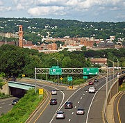
Interstate 84
is an East–West Interstate highway
across the state of Connecticut
into Danbury
, Waterbury
, Hartford
and Union
.
 The interstate's first exit is at the state line, where it enters the city of Danbury
. Here it is designated the Yankee Expressway. Two miles to the east, where US 7
comes in from the south near Danbury Fair Mall
to join I-84, it turns to the north. At the next exit, routes 6
and 202
join the highway.
The four-way concurrency ends after 3 miles (4.8 km), when 7 and 202 split off north towards New Milford
. Route 6 leaves the interstate at the next exit, and I-84 continues east across the countryside. At Exit 11 it turns to the northeast and descends to cross the Housatonic River
on the Rochambeau Bridge, into New Haven County
, then climbs into higher ground to the city of Waterbury
, which it passes on an elevated viaduct
with the eastbound and westbound lanes on different levels. Here the CT 8
expressway intersects.
The eastern heading continues past Waterbury to Milldale
, where Interstate 691
splits off to the east. This section has many left-hand exits and entrances and sharp curves, which were built for a planned network of freeways. I-84 heads northeast towards New Britain
and Hartford
, the state capital and the largest community along its eastern length. After intersecting Interstate 91
, the road crosses the Connecticut River
on the Bulkeley Bridge
, oldest on the Interstate system, then becomes the Wilbur Cross Highway
and continues towards the northeast.
The last exit in Connecticut is Exit 74, an exit for Route 171. I-84 crosses the Massachusetts border in the town of Union
.
to Providence, Rhode Island
.
to Bolton, Connecticut
, then along a never-built section of freeway that would have connected to the US 6
bypass around Willimantic, Connecticut
. Another never-built freeway section would have connected it to Interstate 395 and extended I-84 onto State Road 695 in Connecticut, the easternmost portion of the Connecticut Turnpike
in Plainfield, Connecticut
. From there, it would have roughly followed US 6 through western Rhode Island
to connect to the present-day US 6 freeway in Johnston
. From there, a freeway from Olneyville Square
to the Interstate 95
–Interstate 195 interchange was briefly considered, but abandoned in favor of what later became the Route 6-10 Connector.
s in East Hartford. Another section through Danbury was widened from 4 lanes to 6 lanes in 1985 and 1986. Widening of the highway through Danbury was funded by Union Carbide
as part of building its world headquarters in Danbury.
, many issues remained in Rhode Island
, the biggest of which were major environmental concerns about how the freeway would affect the Scituate Reservoir
, which is the main drinking water supply for Providence
.
, a freeway has been added along the original route of Interstate 84 that will connect to the CT 695 freeway on the Rhode Island
–Connecticut
border.
(at the present-day junction with Interstate 384
) and Sturbridge, Massachusetts
(Interstate 90
) was for a time signed as Interstate 86 (unrelated to present-day Interstate 86
in New York
and Pennsylvania
). Signs stating "I-84 Ends, I-86 to Boston
" (eastbound) and "I-86 Ends, I-84 to Hartford" (westbound) were posted where the change took place. Exit numbering on I-86 was that of the road's predecessor, Route 15
, in a sequence beginning on New York's Hutchinson River Parkway
. Exits were renumbered to correspond with the rest of I-84 in Connecticut when the road was redesignated in 1984. The present I-384 as well as the present US 6 bypass near Willimantic, both of which were a part of what was then I-84's planned easterly continuation, were also numbered I-84 prior to 1984 even though they lacked any direct connection to the rest of I-84 at that time. (One had to use Silver Lane in East Hartford to travel between the two stretches of the highway.) These two sections were re-numbered I-384 and Rte 6 when what was then I-86 was re-numbered I-84.
and Cheshire, Connecticut
has been beset by cost overruns, delays, and construction defects involving storm drains, as state and federal officials have launched criminal investigations stemming from this project. This episode has waned local enthusiasm for a proposed $2 billion reconstruction of the Mixmaster interchange in downtown Waterbury. Cost estimates for the Mixmaster replacement have increased to $3 billion. CT Attorney General Richard Blumenthal
has begun a lawsuit against the contractor and an engineering firm in response to threats from the U.S. DOT to withhold funds from the project. On May 18, 2007, the Waterbury Republican-American
reported this area had defective light poles, while Governor M. Jodi Rell
released an audit report of the construction disaster. A number of DOT personnel were either fired or reprimanded following the scandal. Meanwhile the FBI and a federal grand jury are investigating the now-defunct construction company and the same DOT officials, which may eventually lead to criminal charges in the case.
 I-384
I-384
, a spur route into Manchester
.
Interstate 84 (east)
Interstate 84 is an Interstate Highway extending from Dunmore, Pennsylvania at an interchange with Interstate 81 to Sturbridge, Massachusetts, at an interchange with the Massachusetts Turnpike . I-84 has mile-log junction numbering in Pennsylvania; otherwise, exit numbers are roughly sequential...
is an East–West Interstate highway
Interstate Highway System
The Dwight D. Eisenhower National System of Interstate and Defense Highways, , is a network of limited-access roads including freeways, highways, and expressways forming part of the National Highway System of the United States of America...
across the state of Connecticut
Connecticut
Connecticut is a state in the New England region of the northeastern United States. It is bordered by Rhode Island to the east, Massachusetts to the north, and the state of New York to the west and the south .Connecticut is named for the Connecticut River, the major U.S. river that approximately...
into Danbury
Danbury, Connecticut
Danbury is a city in northern Fairfield County, Connecticut, United States. It had population at the 2010 census of 80,893. Danbury is the fourth largest city in Fairfield County and is the seventh largest city in Connecticut....
, Waterbury
Waterbury, Connecticut
Waterbury is a city in New Haven County, Connecticut, on the Naugatuck River, 33 miles southwest of Hartford and 77 miles northeast of New York City...
, Hartford
Hartford, Connecticut
Hartford is the capital of the U.S. state of Connecticut. The seat of Hartford County until Connecticut disbanded county government in 1960, it is the second most populous city on New England's largest river, the Connecticut River. As of the 2010 Census, Hartford's population was 124,775, making...
and Union
Union, Connecticut
Union is a town in Tolland County, Connecticut, United States. The population was 854 at the 2010 census, making it the least populous town in Connecticut and the second-least populous municipality in Connecticut; only the Borough of Fenwick has fewer people...
.
Route description
Danbury, Connecticut
Danbury is a city in northern Fairfield County, Connecticut, United States. It had population at the 2010 census of 80,893. Danbury is the fourth largest city in Fairfield County and is the seventh largest city in Connecticut....
. Here it is designated the Yankee Expressway. Two miles to the east, where US 7
U.S. Route 7 in Connecticut
In the state of Connecticut, U.S. Route 7 runs from Canaan to Norwalk.-Route description:U.S. 7 in Connecticut is mostly a surface road but has two short expressway sections in the Norwalk and Danbury areas. US 7 begins in Norwalk with a expressway to nearly the Wilton town line...
comes in from the south near Danbury Fair Mall
Danbury Fair Mall
As of 2011, Danbury Fair is the second largest shopping mall in Connecticut as well as the fifth largest in New England. It is located off of Interstate 84 and U.S...
to join I-84, it turns to the north. At the next exit, routes 6
U.S. Route 6 in Connecticut
U.S. Route 6 is the portion of the cross-country U.S. Route 6 within the state of Connecticut. West of Hartford, the route either closely parallels or runs along Interstate 84. Interstate 84 has largely supplanted Route 6 as a through route in western Connecticut. East of Hartford, the route serves...
and 202
U.S. Route 202 in Connecticut
In Connecticut, U.S. Route 202 is usually signed as an east–west route. It enters from the New York state line in Danbury overlapped with U.S. Route 6 and ends at the Massachusetts state line in Granby overlapped with Route 10. US 202 is overlapped with other routes for most of its...
join the highway.
The four-way concurrency ends after 3 miles (4.8 km), when 7 and 202 split off north towards New Milford
New Milford, Connecticut
New Milford is a town in southern Litchfield County, Connecticut, United States north of Danbury, on the Housatonic River. It is the largest town in the state in terms of land area at nearly . The population was 28,671 according to the Census Bureau's 2006 estimates...
. Route 6 leaves the interstate at the next exit, and I-84 continues east across the countryside. At Exit 11 it turns to the northeast and descends to cross the Housatonic River
Housatonic River
The Housatonic River is a river, approximately long, in western Massachusetts and western Connecticut in the United States. It flows south to southeast, and drains about of southwestern New England into Long Island Sound...
on the Rochambeau Bridge, into New Haven County
New Haven County, Connecticut
New Haven County is a county located in the south central part of the U.S. state of Connecticut. As of the 2010 Census, the county population is 862,477 making it the third most populated county in Connecticut. There are 1,340 people per square mile...
, then climbs into higher ground to the city of Waterbury
Waterbury, Connecticut
Waterbury is a city in New Haven County, Connecticut, on the Naugatuck River, 33 miles southwest of Hartford and 77 miles northeast of New York City...
, which it passes on an elevated viaduct
Viaduct
A viaduct is a bridge composed of several small spans. The term viaduct is derived from the Latin via for road and ducere to lead something. However, the Ancient Romans did not use that term per se; it is a modern derivation from an analogy with aqueduct. Like the Roman aqueducts, many early...
with the eastbound and westbound lanes on different levels. Here the CT 8
Route 8 (Connecticut)
Route 8 is the portion of the multistate New England Route 8 within the state of Connecticut. It is a state highway running north–south from Bridgeport, through Waterbury, all the way to the Massachusetts state line where it continues as Route 8...
expressway intersects.
The eastern heading continues past Waterbury to Milldale
Milldale, Connecticut
Milldale is a neighborhood in the incorporated town of Southington, Hartford County, Connecticut.-Geography:Milldale is located at geographical coordinates 41° 33′ 57" North, 72° 53′ 30" West .-External links:*...
, where Interstate 691
Interstate 691
Interstate 691 is a portion of the Interstate Highway System in Connecticut beginning at Interstate 91 in Meriden and ending at Interstate 84 near the Cheshire-Southington town line. It is in length, including of the exit ramp to the merge with westbound I-84.I-691 is also known as the Henry D...
splits off to the east. This section has many left-hand exits and entrances and sharp curves, which were built for a planned network of freeways. I-84 heads northeast towards New Britain
New Britain, Connecticut
New Britain is a city in Hartford County, Connecticut, United States. It is located approximately 9 miles southwest of Hartford. According to 2006 Census Bureau estimates, the population of the city is 71,254....
and Hartford
Hartford, Connecticut
Hartford is the capital of the U.S. state of Connecticut. The seat of Hartford County until Connecticut disbanded county government in 1960, it is the second most populous city on New England's largest river, the Connecticut River. As of the 2010 Census, Hartford's population was 124,775, making...
, the state capital and the largest community along its eastern length. After intersecting Interstate 91
Interstate 91
Interstate 91 is an Interstate Highway in the New England region of the United States. It provides the primary north–south thoroughfare in the western part of New England...
, the road crosses the Connecticut River
Connecticut River
The Connecticut River is the largest and longest river in New England, and also an American Heritage River. It flows roughly south, starting from the Fourth Connecticut Lake in New Hampshire. After flowing through the remaining Connecticut Lakes and Lake Francis, it defines the border between the...
on the Bulkeley Bridge
Bulkeley Bridge
The Bulkeley Bridge is a stone arch bridge composed of nine spans located in Hartford, Connecticut. The bridge carries Interstate 84, U.S. Route 6 and U.S. Route 44 across the Connecticut River, connecting Hartford to East Hartford...
, oldest on the Interstate system, then becomes the Wilbur Cross Highway
Wilbur Cross Highway
The Wilbur Cross Highway is the designation for the portion of old Route 15 from Wethersfield in Connecticut, through Hartford and Manchester, to the Massachusetts Turnpike in Sturbridge, Massachusetts. The highway was built in the 1940s before the Interstate Highway era...
and continues towards the northeast.
The last exit in Connecticut is Exit 74, an exit for Route 171. I-84 crosses the Massachusetts border in the town of Union
Union, Connecticut
Union is a town in Tolland County, Connecticut, United States. The population was 854 at the 2010 census, making it the least populous town in Connecticut and the second-least populous municipality in Connecticut; only the Borough of Fenwick has fewer people...
.
Road to Providence
Interstate 84 was originally to head east from Hartford, ConnecticutHartford, Connecticut
Hartford is the capital of the U.S. state of Connecticut. The seat of Hartford County until Connecticut disbanded county government in 1960, it is the second most populous city on New England's largest river, the Connecticut River. As of the 2010 Census, Hartford's population was 124,775, making...
to Providence, Rhode Island
Providence, Rhode Island
Providence is the capital and most populous city of Rhode Island and was one of the first cities established in the United States. Located in Providence County, it is the third largest city in the New England region...
.
Original route
The original route of Interstate 84 would have used present-day Interstate 384Interstate 384
Interstate 384 is an Interstate Highway located entirely within the state of Connecticut. It runs east to west, going from Interstate 84 in East Hartford to U.S. Route 6/U.S...
to Bolton, Connecticut
Bolton, Connecticut
Bolton is a town in Tolland County, Connecticut, United States. The population was 5,017 at the 2000 census. Bolton was incorporated in October 1720 and is governed by town meeting.-History:...
, then along a never-built section of freeway that would have connected to the US 6
U.S. Route 6
U.S. Route 6 , also called the Grand Army of the Republic Highway, a name that honors an American Civil War veterans association, is a main route of the U.S. Highway system, running east-northeast from Bishop, California to Provincetown, Massachusetts. Until 1964, it continued south from Bishop to...
bypass around Willimantic, Connecticut
Willimantic, Connecticut
Willimantic is a census-designated place and former city located in the town of Windham in Windham County, Connecticut, United States. The population was estimated at 15,823 at the 2000 census. It is home to Eastern Connecticut State University, as well as the Windham Textile and History Museum....
. Another never-built freeway section would have connected it to Interstate 395 and extended I-84 onto State Road 695 in Connecticut, the easternmost portion of the Connecticut Turnpike
Connecticut Turnpike
The Connecticut Turnpike, known now as the Governor John Davis Lodge Turnpike, is a freeway in Connecticut that runs from Greenwich to Killingly. It is signed as Interstate 95 from the New York state line at Greenwich to East Lyme, and then as Interstate 395 from East Lyme to Plainfield...
in Plainfield, Connecticut
Plainfield, Connecticut
Plainfield is a town in Windham County, Connecticut, United States. The population was 14,619 at the 2000 census. The town comprises four villages: Plainfield , Moosup , Wauregan , and Central Village . Each village has their own respective United States Post Office and fire department...
. From there, it would have roughly followed US 6 through western Rhode Island
Rhode Island
The state of Rhode Island and Providence Plantations, more commonly referred to as Rhode Island , is a state in the New England region of the United States. It is the smallest U.S. state by area...
to connect to the present-day US 6 freeway in Johnston
Johnston, Rhode Island
Johnston is a town in Providence County, Rhode Island, United States. The population was 28,769 at the 2010 census. Johnston is the site of the Clemence Irons House a stone-ender museum and the only landfill in Rhode Island...
. From there, a freeway from Olneyville Square
Olneyville Square
Olneyville is a neighborhood in Providence, Rhode Island bordered by Atwells Avenue to the north, U.S. Route 6 to the south and Rhode Island Route 10 to the east. The Woonasquatucket River runs through the southern portion of the neighborhood...
to the Interstate 95
Interstate 95 in Rhode Island
Interstate 95, the main north–south Interstate Highway on the east coast of the United States, runs generally southwest-northeast through the U.S. state of Rhode Island. It runs from the border with Connecticut near Westerly through Warwick and Providence and to the Massachusetts state line...
–Interstate 195 interchange was briefly considered, but abandoned in favor of what later became the Route 6-10 Connector.
Upgrades
Sections of I-84 in Connecticut were reconstructed and widened in the 1980s. The former I-86 portion from East Hartford to the Massachusetts state line was completely rebuilt from a narrow 4-lane freeway to a much wider profile ranging from 6 lanes at the Massachusetts state line, expanding to 8 lanes in Vernon, to 12 lanes with HOV laneHigh-occupancy vehicle lane
In transportation engineering and transportation planning, a high-occupancy vehicle lane is a lane reserved for vehicles with a driver and one or more passengers...
s in East Hartford. Another section through Danbury was widened from 4 lanes to 6 lanes in 1985 and 1986. Widening of the highway through Danbury was funded by Union Carbide
Union Carbide
Union Carbide Corporation is a wholly owned subsidiary of The Dow Chemical Company. It currently employs more than 2,400 people. Union Carbide primarily produces chemicals and polymers that undergo one or more further conversions by customers before reaching consumers. Some are high-volume...
as part of building its world headquarters in Danbury.
Environmental concerns
Though the route was basically set in stone in ConnecticutConnecticut
Connecticut is a state in the New England region of the northeastern United States. It is bordered by Rhode Island to the east, Massachusetts to the north, and the state of New York to the west and the south .Connecticut is named for the Connecticut River, the major U.S. river that approximately...
, many issues remained in Rhode Island
Rhode Island
The state of Rhode Island and Providence Plantations, more commonly referred to as Rhode Island , is a state in the New England region of the United States. It is the smallest U.S. state by area...
, the biggest of which were major environmental concerns about how the freeway would affect the Scituate Reservoir
Scituate Reservoir
The Scituate Reservoir is the largest inland body of water in the state of Rhode Island. It has an aggregate capacity of and a surface area of 5.3 square miles...
, which is the main drinking water supply for Providence
Providence, Rhode Island
Providence is the capital and most populous city of Rhode Island and was one of the first cities established in the United States. Located in Providence County, it is the third largest city in the New England region...
.
Long-range plans
In the 1992 long-range transportation plan released by the Rhode Island Department of TransportationRhode Island Department of Transportation
The Rhode Island Department of Transportation is a Rhode Island state government agency charged with construction, maintenance and inspection of a wide range of transportation infrastructure. These include 1,102 miles of state roads and highways, 772 bridges, and 777 traffic signals...
, a freeway has been added along the original route of Interstate 84 that will connect to the CT 695 freeway on the Rhode Island
Rhode Island
The state of Rhode Island and Providence Plantations, more commonly referred to as Rhode Island , is a state in the New England region of the United States. It is the smallest U.S. state by area...
–Connecticut
Connecticut
Connecticut is a state in the New England region of the northeastern United States. It is bordered by Rhode Island to the east, Massachusetts to the north, and the state of New York to the west and the south .Connecticut is named for the Connecticut River, the major U.S. river that approximately...
border.
I-86 relation
The section of I-84 between East Hartford, ConnecticutEast Hartford, Connecticut
East Hartford is a town in Hartford County, Connecticut, United States. The population was 51,252 at the 2010 census.-Geography:...
(at the present-day junction with Interstate 384
Interstate 384
Interstate 384 is an Interstate Highway located entirely within the state of Connecticut. It runs east to west, going from Interstate 84 in East Hartford to U.S. Route 6/U.S...
) and Sturbridge, Massachusetts
Sturbridge, Massachusetts
Sturbridge is a town in Worcester County, Massachusetts, United States. It is home to Old Sturbridge Village living history museum and other sites of historical interest such as Tantiusques.The population was 9,268 at the 2010 census...
(Interstate 90
Interstate 90
Interstate 90 is the longest Interstate Highway in the United States at . It is the northernmost coast-to-coast interstate, and parallels US 20 for the most part. Its western terminus is in Seattle, at Edgar Martinez Drive S. near Safeco Field and CenturyLink Field, and its eastern terminus is in...
) was for a time signed as Interstate 86 (unrelated to present-day Interstate 86
Interstate 86 (east)
Interstate 86 is an Interstate Highway that extends for through northwestern Pennsylvania and southern New York in the United States...
in New York
New York
New York is a state in the Northeastern region of the United States. It is the nation's third most populous state. New York is bordered by New Jersey and Pennsylvania to the south, and by Connecticut, Massachusetts and Vermont to the east...
and Pennsylvania
Pennsylvania
The Commonwealth of Pennsylvania is a U.S. state that is located in the Northeastern and Mid-Atlantic regions of the United States. The state borders Delaware and Maryland to the south, West Virginia to the southwest, Ohio to the west, New York and Ontario, Canada, to the north, and New Jersey to...
). Signs stating "I-84 Ends, I-86 to Boston
Boston
Boston is the capital of and largest city in Massachusetts, and is one of the oldest cities in the United States. The largest city in New England, Boston is regarded as the unofficial "Capital of New England" for its economic and cultural impact on the entire New England region. The city proper had...
" (eastbound) and "I-86 Ends, I-84 to Hartford" (westbound) were posted where the change took place. Exit numbering on I-86 was that of the road's predecessor, Route 15
Route 15 (Connecticut)
Route 15 is a state highway in the U.S. state of Connecticut that runs from a connection with New York's Hutchinson River Parkway in Greenwich, Connecticut to its northern terminus intersecting with Interstate 84 in East Hartford, Connecticut...
, in a sequence beginning on New York's Hutchinson River Parkway
Hutchinson River Parkway
The Hutchinson River Parkway is a north–south parkway in southern New York, United States. It extends for from the massive Bruckner Interchange in the Throgs Neck section of the Bronx to the New York – Connecticut state line at Rye Brook...
. Exits were renumbered to correspond with the rest of I-84 in Connecticut when the road was redesignated in 1984. The present I-384 as well as the present US 6 bypass near Willimantic, both of which were a part of what was then I-84's planned easterly continuation, were also numbered I-84 prior to 1984 even though they lacked any direct connection to the rest of I-84 at that time. (One had to use Silver Lane in East Hartford to travel between the two stretches of the highway.) These two sections were re-numbered I-384 and Rte 6 when what was then I-86 was re-numbered I-84.
Widening projects in Waterbury
A widening project along the congested stretch of I-84 through WaterburyWaterbury, Connecticut
Waterbury is a city in New Haven County, Connecticut, on the Naugatuck River, 33 miles southwest of Hartford and 77 miles northeast of New York City...
and Cheshire, Connecticut
Cheshire, Connecticut
Cheshire is a town in New Haven County, Connecticut, United States. The population was 28,543 at the 2000 census. The center of population of Connecticut is located in Cheshire. In 2009 Cheshire was ranked 72 in Money Magazine's 100 Best Places to Live.Likewise, in 2011 Cheshire was ranked 73 in...
has been beset by cost overruns, delays, and construction defects involving storm drains, as state and federal officials have launched criminal investigations stemming from this project. This episode has waned local enthusiasm for a proposed $2 billion reconstruction of the Mixmaster interchange in downtown Waterbury. Cost estimates for the Mixmaster replacement have increased to $3 billion. CT Attorney General Richard Blumenthal
Richard Blumenthal
Richard Blumenthal is the junior United States Senator from Connecticut and a member of the Democratic Party. Previously, he served as Attorney General of Connecticut....
has begun a lawsuit against the contractor and an engineering firm in response to threats from the U.S. DOT to withhold funds from the project. On May 18, 2007, the Waterbury Republican-American
Waterbury Republican-American
The Republican-American, headquartered in Waterbury, Connecticut is the United States' 193rd-largest newspaper with an average Sunday circulation of 61,100...
reported this area had defective light poles, while Governor M. Jodi Rell
M. Jodi Rell
Mary Jodi Rell is a Republican politician and was the 87th Governor of the U.S. state of Connecticut from 2004 until 2011. She was the Lieutenant Governor of Connecticut under Governor John G. Rowland, who resigned during a corruption investigation. Rell is Connecticut's second female Governor,...
released an audit report of the construction disaster. A number of DOT personnel were either fired or reprimanded following the scandal. Meanwhile the FBI and a federal grand jury are investigating the now-defunct construction company and the same DOT officials, which may eventually lead to criminal charges in the case.
Exit list
| Town New England town The New England town is the basic unit of local government in each of the six New England states. Without a direct counterpart in most other U.S. states, New England towns are conceptually similar to civil townships in other states, but are incorporated, possessing powers like cities in other... |
HOV High-occupancy vehicle lane In transportation engineering and transportation planning, a high-occupancy vehicle lane is a lane reserved for vehicles with a driver and one or more passengers... |
# Exit number An exit number is a number assigned to a road junction, usually an exit from a freeway. It is usually marked on the same sign as the destinations of the exit, as well as a sign in the gore.... |
Destinations | Notes |
|---|---|---|---|---|
| Danbury Danbury, Connecticut Danbury is a city in northern Fairfield County, Connecticut, United States. It had population at the 2010 census of 80,893. Danbury is the fourth largest city in Fairfield County and is the seventh largest city in Connecticut.... |
1 | Saw Mill Rd. – Ridgebury | ||
| 2 | Old Ridgebury Rd. – Ridgebury, Mill Plain | Access to the Connecticut Welcome Center eastbound | ||
| 3 | West end of US 7 overlap | |||
| 4 | West end of US 6/US 202 overlap | |||
| 5 | ||||
| 6 | Westbound exit and eastbound entrance | |||
| 7 | East end of US 7/US 202 overlap | |||
| Danbury Danbury, Connecticut Danbury is a city in northern Fairfield County, Connecticut, United States. It had population at the 2010 census of 80,893. Danbury is the fourth largest city in Fairfield County and is the seventh largest city in Connecticut.... /Bethel Bethel, Connecticut Bethel is a town in Fairfield County, Connecticut, United States, about sixty miles from New York City. Its population was 18,584 at the 2010 census. The town center is defined by the U.S. Census Bureau as a census-designated place... |
8 | East end of US 6 overlap | ||
| Newtown Newtown, Connecticut Newtown is a town in Fairfield County, Connecticut, United States. The population was 27,560 at the 2010 census. Newtown was founded in 1705 and incorporated in 1711.-Government:... |
9 | |||
| 10 | West end of US 6 overlap | |||
| 11 | Connection to Route 34 is SSR 490 |
|||
| Rochambeau Bridge over the Housatonic River Housatonic River The Housatonic River is a river, approximately long, in western Massachusetts and western Connecticut in the United States. It flows south to southeast, and drains about of southwestern New England into Long Island Sound... |
||||
| Southbury Southbury, Connecticut Southbury is a town located in western New Haven County, Connecticut, USA. Southbury is located north of Oxford and Newtown; it also is east of Brookfield. Southbury's population was 18,567 at the 2000 census.... |
||||
| 13 | River Road – Southbury Southbury, Connecticut Southbury is a town located in western New Haven County, Connecticut, USA. Southbury is located north of Oxford and Newtown; it also is east of Brookfield. Southbury's population was 18,567 at the 2000 census.... |
Eastbound exit and westbound entrance | ||
| 14 | ||||
| 15 | East end of US 6 overlap | |||
| 16 | ||||
| Middlebury Middlebury, Connecticut Middlebury is a town in New Haven County, Connecticut, United States. The population was 6,451 at the 2000 census.-Geography:According to the United States Census Bureau, the town has a total area of , of which, of it is land and of it is water.... |
17 | Eastbound exit and westbound entrance | ||
| Waterbury Waterbury, Connecticut Waterbury is a city in New Haven County, Connecticut, on the Naugatuck River, 33 miles southwest of Hartford and 77 miles northeast of New York City... |
17 | Westbound exit and eastbound entrance | ||
| 18 | Chase Parkway (SR 845) – Waterbury Waterbury, Connecticut Waterbury is a city in New Haven County, Connecticut, on the Naugatuck River, 33 miles southwest of Hartford and 77 miles northeast of New York City... |
Eastbound exit and westbound entrance | ||
| 18 | West Main St., Highland Ave. – Waterbury Waterbury, Connecticut Waterbury is a city in New Haven County, Connecticut, on the Naugatuck River, 33 miles southwest of Hartford and 77 miles northeast of New York City... |
Westbound exit and eastbound entrance | ||
| 19 | ||||
| 20 | ||||
| 21 | Meadow Street, Bank Street, Mixmaster Mixmaster Mixmaster may refer to:*Mixmaster, a brand of Sunbeam Products electric kitchen mixer*The Mixmaster anonymous remailer, a Type II anonymous remailer which sends messages in fixed-size packets and reorders them, preventing anyone watching the messages go in and out of remailers from tracing... |
|||
| 22 | Baldwin Street – Downtown Waterbury Waterbury, Connecticut Waterbury is a city in New Haven County, Connecticut, on the Naugatuck River, 33 miles southwest of Hartford and 77 miles northeast of New York City... |
|||
| 22 | Union Street – Downtown Waterbury Waterbury, Connecticut Waterbury is a city in New Haven County, Connecticut, on the Naugatuck River, 33 miles southwest of Hartford and 77 miles northeast of New York City... |
|||
| 23 | ||||
| 24 | Harpers Ferry Rd. | No entrance ramps; signed as exit 25 eastbound | ||
| 25 | Reidville Rd., E. Main St., Scott Rd. | Eastbound exit is via exit 25 (Harpers Ferry Road) | ||
| 25A | Austin Rd. – Waterbury Waterbury, Connecticut Waterbury is a city in New Haven County, Connecticut, on the Naugatuck River, 33 miles southwest of Hartford and 77 miles northeast of New York City... , Prospect Prospect, Connecticut Prospect is a town in New Haven County, Connecticut, United States. The population was 8,707 at the 2000 census.-Geography:According to the United States Census Bureau, the town has a total area of , of which, of it is land and of it is water... |
|||
| Cheshire Cheshire, Connecticut Cheshire is a town in New Haven County, Connecticut, United States. The population was 28,543 at the 2000 census. The center of population of Connecticut is located in Cheshire. In 2009 Cheshire was ranked 72 in Money Magazine's 100 Best Places to Live.Likewise, in 2011 Cheshire was ranked 73 in... |
26 | |||
| 27 | ||||
| Southington Southington, Connecticut Southington is a town in Hartford County, Connecticut, United States. It is part of Connecticut's 1st congressional district. It is situated about 20 miles southwest of Hartford, about 80 miles northeast of New York City, 105 miles southwest of Boston and 77 miles west of Providence... |
||||
| 28 | ||||
| 29 | Westbound exit and eastbound entrance; connection is SR 597 | |||
| 30 | W. Main St., Marion Ave. – Downtown Southington Southington, Connecticut Southington is a town in Hartford County, Connecticut, United States. It is part of Connecticut's 1st congressional district. It is situated about 20 miles southwest of Hartford, about 80 miles northeast of New York City, 105 miles southwest of Boston and 77 miles west of Providence... , Plantsville Plantsville, Connecticut Plantsville is a neighborhood and census-designated place in the town of Southington, Hartford County, Connecticut. It is centered at the merger between South Main Street and West Main Street... |
|||
| 31 | ||||
| 32 | ||||
| Plainville Plainville, Connecticut Plainville is a town in Hartford County, Connecticut, United States. The population was 17,328 at the 2000 census.-Geography:According to the United States Census Bureau, the town has a total area of 9.8 square miles , of which 9.8 square miles is land and 0.1 square miles is water... |
33 | West end of Route 72 overlap | ||
| 34 | No westbound exit | |||
| Plainville Plainville, Connecticut Plainville is a town in Hartford County, Connecticut, United States. The population was 17,328 at the 2000 census.-Geography:According to the United States Census Bureau, the town has a total area of 9.8 square miles , of which 9.8 square miles is land and 0.1 square miles is water... /New Britain New Britain, Connecticut New Britain is a city in Hartford County, Connecticut, United States. It is located approximately 9 miles southwest of Hartford. According to 2006 Census Bureau estimates, the population of the city is 71,254.... |
35 | East end of Route 72 overlap | ||
| New Britain New Britain, Connecticut New Britain is a city in Hartford County, Connecticut, United States. It is located approximately 9 miles southwest of Hartford. According to 2006 Census Bureau estimates, the population of the city is 71,254.... |
36 | Slater Road | ||
| Farmington Farmington, Connecticut Farmington is a town located in Hartford County in the Farmington Valley area of central Connecticut in the United States. The population was 25,340 at the 2010 census. It is home to the world headquarters of several large corporations including Carrier Corporation, Otis Elevator Company, and Carvel... |
37 | Fienemann Rd. – New Britain New Britain, Connecticut New Britain is a city in Hartford County, Connecticut, United States. It is located approximately 9 miles southwest of Hartford. According to 2006 Census Bureau estimates, the population of the city is 71,254.... , Farmington Farmington, Connecticut Farmington is a town located in Hartford County in the Farmington Valley area of central Connecticut in the United States. The population was 25,340 at the 2010 census. It is home to the world headquarters of several large corporations including Carrier Corporation, Otis Elevator Company, and Carvel... |
||
| 38 | West end of US 6 overlap | |||
| 39 | Connection is SR 508 | |||
| 39A | ||||
| West Hartford West Hartford, Connecticut West Hartford is a town located in Hartford County, Connecticut, United States. The town was incorporated in 1854. Prior to that date, the town was a parish of Hartford.... |
40 | (EB) Ridgewood Ave. – West Hartford West Hartford, Connecticut West Hartford is a town located in Hartford County, Connecticut, United States. The town was incorporated in 1854. Prior to that date, the town was a parish of Hartford.... (WB) |
||
| 41 | ||||
| 42 | Trout Brook Drive – Elmwood West Hartford, Connecticut West Hartford is a town located in Hartford County, Connecticut, United States. The town was incorporated in 1854. Prior to that date, the town was a parish of Hartford.... |
Westbound exit and eastbound entrance | ||
| 43 | Park Road – West Hartford Center West Hartford, Connecticut West Hartford is a town located in Hartford County, Connecticut, United States. The town was incorporated in 1854. Prior to that date, the town was a parish of Hartford.... |
Connection is SR 501 | ||
| 44 | Caya Ave., Prospect Ave. (EB) Kane St. (WB) |
|||
| Hartford Hartford, Connecticut Hartford is the capital of the U.S. state of Connecticut. The seat of Hartford County until Connecticut disbanded county government in 1960, it is the second most populous city on New England's largest river, the Connecticut River. As of the 2010 Census, Hartford's population was 124,775, making... |
||||
| 45 | Flatbush Avenue | Westbound exit and eastbound entrance; connection is SR 504 | ||
| 46 | Sisson Avenue | Connection is SR 503 | ||
| 47 | Sigourney Street | Westbound exit and eastbound entrance | ||
| 48A | Asylum Street | Signed as exit 48 westbound | ||
| 48B | Capitol Avenue | Eastbound exit and westbound entrance | ||
| 49 | Ann Uccello Street | Eastbound exit and westbound entrance. | ||
| 50 | West end of US 44 overlap | |||
| 51 | ||||
| 52 | Eastbound exit and westbound entrance | |||
| Bulkeley Bridge Bulkeley Bridge The Bulkeley Bridge is a stone arch bridge composed of nine spans located in Hartford, Connecticut. The bridge carries Interstate 84, U.S. Route 6 and U.S. Route 44 across the Connecticut River, connecting Hartford to East Hartford... over the Connecticut River Connecticut River The Connecticut River is the largest and longest river in New England, and also an American Heritage River. It flows roughly south, starting from the Fourth Connecticut Lake in New Hampshire. After flowing through the remaining Connecticut Lakes and Lake Francis, it defines the border between the... |
||||
| East Hartford East Hartford, Connecticut East Hartford is a town in Hartford County, Connecticut, United States. The population was 51,252 at the 2010 census.-Geography:... |
||||
| 53 | East end of US 44 overlap; no westbound exit; also connects with East River Drive | |||
| 54 | Westbound exit and eastbound entrance | |||
| 55 | ||||
| 56 | Governor Street – Downtown East Hartford East Hartford, Connecticut East Hartford is a town in Hartford County, Connecticut, United States. The population was 51,252 at the 2010 census.-Geography:... |
Connection is SR 500 | ||
| 57 | Westbound exit and eastbound entrance. | |||
| 58 | Roberts Street (SR 518), Silver Lane (SR 502) – E. Hartford East Hartford, Connecticut East Hartford is a town in Hartford County, Connecticut, United States. The population was 51,252 at the 2010 census.-Geography:... |
|||
| 59 | ||||
| Manchester Manchester, Connecticut Manchester is a township and city in Hartford County, Connecticut, United States. As of the 2010 census, the town had a total population of 58,241.- History :... |
60 | East end of US 6 overlap; westbound exit combined with exit 62 | ||
| 61 | ||||
| 62 | Buckland St. – S. Windsor South Windsor, Connecticut -History:In 1659, Thomas Burnham purchased the tract of land now covered by the towns of South Windsor and East Hartford from Tantinomo, chief sachem of the Podunk Indians. Burnham lived on the land and later willed it to his nine children... , Manchester Manchester, Connecticut Manchester is a township and city in Hartford County, Connecticut, United States. As of the 2010 census, the town had a total population of 58,241.- History :... |
|||
| 63 | ||||
| Vernon Vernon, Connecticut Vernon is a town in Tolland County, Connecticut, United States. The population was 29,179 at the 2010 census.Vernon was incorporated in October, 1808, from Bolton. Vernon contains the former city of Rockville, incorporated in January, 1889. The town of Vernon and city of Rockville consolidated as a... |
64 | Eastbound exit 65 leaves I-84 on the same ramp as exit 64 | ||
| 65 | Eastbound exit is combined with exit 64 | |||
| 66 | Tunnel Road – Vernon Vernon, Connecticut Vernon is a town in Tolland County, Connecticut, United States. The population was 29,179 at the 2010 census.Vernon was incorporated in October, 1808, from Bolton. Vernon contains the former city of Rockville, incorporated in January, 1889. The town of Vernon and city of Rockville consolidated as a... , Bolton Bolton, Connecticut Bolton is a town in Tolland County, Connecticut, United States. The population was 5,017 at the 2000 census. Bolton was incorporated in October 1720 and is governed by town meeting.-History:... |
|||
| 67 | ||||
| Tolland Tolland, Connecticut Tolland is a town in Tolland County, Connecticut, United States. The population was 13,146 at the 2000 census.Tolland was named in May, 1715, and incorporated in May, 1722. According to some, the town derives its name from being a toll station on the old road between Boston and New York. ... |
68 | University of Connecticut | ||
| 69 | ||||
| Willington Willington, Connecticut Willington is a town in Tolland County, Connecticut, United States. The population was 5,959 at the 2000 census.The Willimantic River borders the town on the west. Willington is about 25 miles northeast of Hartford on Interstate 84, which also provides a connection to Boston, via the Massachusetts... |
70 | |||
| 71 | ||||
| Ashford Ashford, Connecticut President George Washington, returning from his tour of the country in the fall of 1789, was chagrined to be involuntarily abandoned in the village on a Sunday... /Union Union, Connecticut Union is a town in Tolland County, Connecticut, United States. The population was 854 at the 2010 census, making it the least populous town in Connecticut and the second-least populous municipality in Connecticut; only the Borough of Fenwick has fewer people... |
72 | |||
| Union Union, Connecticut Union is a town in Tolland County, Connecticut, United States. The population was 854 at the 2010 census, making it the least populous town in Connecticut and the second-least populous municipality in Connecticut; only the Borough of Fenwick has fewer people... |
||||
| 73 | ||||
| 74 | , Holland | |||
Auxiliary route
I-384Interstate 384
Interstate 384 is an Interstate Highway located entirely within the state of Connecticut. It runs east to west, going from Interstate 84 in East Hartford to U.S. Route 6/U.S...
, a spur route into Manchester
Manchester, Connecticut
Manchester is a township and city in Hartford County, Connecticut, United States. As of the 2010 census, the town had a total population of 58,241.- History :...
.