
Viaduct
Encyclopedia
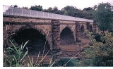
A viaduct is a bridge
composed of several small spans. The term viaduct is derived from the Latin
via for road and ducere to lead something. However, the Ancient Romans
did not use that term per se; it is a modern derivation from an analogy with aqueduct
. Like the Roman aqueduct
s, many early viaducts comprised a series of arches of roughly equal length. Viaducts may span land or water or both.
The longest viaduct in antiquity
may have been the Pont Serme
which crossed wide marshes in southern France. Viaducts are commonly used in many cities which are railroad centers, such as Chicago
, Atlanta, Birmingham
, London
, and Manchester
. These viaducts cross the large railroad yards that are needed for freight trains there, and also cross the multi-track railroad lines that are needed for heavy railroad traffic. These viaducts keep highway
and city street traffic from having to be continually interrupted by the train
traffic. Likewise, some viaducts carry railroads over large valleys, or they carry railroads over cities with lots of cross-streets and avenues. The example of Viaduct on Expressways are Alabang Viaduct in South Luzon Expressway
in Muntinlupa City
, Philippines
that crosses Alabang-Zapote Road in Barangay Alabang the viaduct reaches until Filinvest Interchange. In the north the Pulilan-Apalit Viaduct known as Candaba viaduct in North Luzon Expressway
in Philippines
is raised over the Candaba swamp from Pulilan, Bulacan
until it reaches Apalit, Pampanga
. This keeps the highway open to traffic, even when the swamp gets flooded during the rainy season. It has a view of Mt. Arayat, which is the lone mountain in Central Plain of Luzon.
Many viaducts over land connect points of similar height in a landscape, usually by bridging a river valley
or other eroded opening in an otherwise flat area. Often such valleys had roads descending either side (with a small bridge over the river, where necessary) that become inadequate for the traffic load, necessitating a viaduct for "through" traffic. Such bridges also lend themselves for use by rail
traffic, which requires straighter and flatter routes. Some viaducts have more than one deck, such that one deck has vehicular traffic and another deck having rail traffic. One example of this is the Prince Edward Viaduct
in Toronto
, Canada
, that carries motor traffic on the top deck as Bloor Street
, and metro as the Bloor-Danforth subway line
on the lower deck, over the steep Don River valley
. Others were built to span settled areas and crossed over roads beneath - the reason for many viaducts in London.
Viaducts over water are often combined with other types of bridges or tunnels to cross navigable waters. The viaduct sections, while less expensive to design and build than tunnels or bridges with larger spans, typically lack sufficient horizontal and vertical clearance for large ships. See the Chesapeake Bay Bridge-Tunnel
.
The Millau Viaduct
is a cable-stayed road-bridge that spans the valley of the River Tarn near Millau
in southern France. Designed by the French bridge engineer Michel Virlogeux
, in collaboration with architect Norman Robert Foster, it is the tallest vehicular bridge in the world, with one pier's summit at 343 metres (1,125 ft)—slightly taller than the Eiffel Tower
and only 38 m (125 ft) shorter than the Empire State Building
. It was formally dedicated on 14 December 2004 and opened to traffic two days later. The viaduct Danyang–Kunshan Grand Bridge
in China is the longest bridge in the world according to Guinness World Records
.
In Romance languages
, the word viaduct refers to a bridge which spans only land. A bridge spanning water is called ponte
.
(Central Artery
), Seoul
, Tokyo
, Toronto
(Gardiner Expressway
). But some were demolished because they were ugly and divided the city. However in developing nations such as Thailand
, India
(Delhi-Gurgaon Expressway
), China
, Bangladesh
, Pakistan
, elevated expressways have been built and more are under construction to improve traffic flow, particularly as a workaround of land shortage when built atop surface roads.
Bridge
A bridge is a structure built to span physical obstacles such as a body of water, valley, or road, for the purpose of providing passage over the obstacle...
composed of several small spans. The term viaduct is derived from the Latin
Latin
Latin is an Italic language originally spoken in Latium and Ancient Rome. It, along with most European languages, is a descendant of the ancient Proto-Indo-European language. Although it is considered a dead language, a number of scholars and members of the Christian clergy speak it fluently, and...
via for road and ducere to lead something. However, the Ancient Romans
Ancient Rome
Ancient Rome was a thriving civilization that grew on the Italian Peninsula as early as the 8th century BC. Located along the Mediterranean Sea and centered on the city of Rome, it expanded to one of the largest empires in the ancient world....
did not use that term per se; it is a modern derivation from an analogy with aqueduct
Aqueduct
An aqueduct is a water supply or navigable channel constructed to convey water. In modern engineering, the term is used for any system of pipes, ditches, canals, tunnels, and other structures used for this purpose....
. Like the Roman aqueduct
Roman aqueduct
The Romans constructed numerous aqueducts to serve any large city in their empire, as well as many small towns and industrial sites. The city of Rome had the largest concentration of aqueducts, with water being supplied by eleven aqueducts constructed over a period of about 500 years...
s, many early viaducts comprised a series of arches of roughly equal length. Viaducts may span land or water or both.
The longest viaduct in antiquity
Ancient history
Ancient history is the study of the written past from the beginning of recorded human history to the Early Middle Ages. The span of recorded history is roughly 5,000 years, with Cuneiform script, the oldest discovered form of coherent writing, from the protoliterate period around the 30th century BC...
may have been the Pont Serme
Pont Serme
The Pont Serme or Pons Selinus, later called the Pons Septimus, was a Roman bridge of the Via Domitia in Hérault, southern France. The approximately 1500 m long viaduct crossed the wide marshes of the Orb River and the Etang de Capestang west of Béziers, surpassing in terms of length even the...
which crossed wide marshes in southern France. Viaducts are commonly used in many cities which are railroad centers, such as Chicago
Chicago
Chicago is the largest city in the US state of Illinois. With nearly 2.7 million residents, it is the most populous city in the Midwestern United States and the third most populous in the US, after New York City and Los Angeles...
, Atlanta, Birmingham
Birmingham, Alabama
Birmingham is the largest city in Alabama. The city is the county seat of Jefferson County. According to the 2010 United States Census, Birmingham had a population of 212,237. The Birmingham-Hoover Metropolitan Area, in estimate by the U.S...
, London
London
London is the capital city of :England and the :United Kingdom, the largest metropolitan area in the United Kingdom, and the largest urban zone in the European Union by most measures. Located on the River Thames, London has been a major settlement for two millennia, its history going back to its...
, and Manchester
Manchester
Manchester is a city and metropolitan borough in Greater Manchester, England. According to the Office for National Statistics, the 2010 mid-year population estimate for Manchester was 498,800. Manchester lies within one of the UK's largest metropolitan areas, the metropolitan county of Greater...
. These viaducts cross the large railroad yards that are needed for freight trains there, and also cross the multi-track railroad lines that are needed for heavy railroad traffic. These viaducts keep highway
Highway
A highway is any public road. In American English, the term is common and almost always designates major roads. In British English, the term designates any road open to the public. Any interconnected set of highways can be variously referred to as a "highway system", a "highway network", or a...
and city street traffic from having to be continually interrupted by the train
Train
A train is a connected series of vehicles for rail transport that move along a track to transport cargo or passengers from one place to another place. The track usually consists of two rails, but might also be a monorail or maglev guideway.Propulsion for the train is provided by a separate...
traffic. Likewise, some viaducts carry railroads over large valleys, or they carry railroads over cities with lots of cross-streets and avenues. The example of Viaduct on Expressways are Alabang Viaduct in South Luzon Expressway
South Luzon Expressway
The South Luzon Expressway ', which is formerly called the South Superhighway ', and officially known as Radial Road 3 or R-3, is a network of three expressways that connects Metro Manila to the provinces of the CALABARZON region in the Philippines...
in Muntinlupa City
Muntinlupa City
The City of Muntinlupa is the southernmost city in Philippine National Capital Region. It is bordered on the north by Taguig City; to the northwest by Parañaque City; by Las Piñas City to the west; to the southwest by the city of Bacoor, Cavite; by the city of San Pedro, Laguna; and by Laguna de...
, Philippines
Philippines
The Philippines , officially known as the Republic of the Philippines , is a country in Southeast Asia in the western Pacific Ocean. To its north across the Luzon Strait lies Taiwan. West across the South China Sea sits Vietnam...
that crosses Alabang-Zapote Road in Barangay Alabang the viaduct reaches until Filinvest Interchange. In the north the Pulilan-Apalit Viaduct known as Candaba viaduct in North Luzon Expressway
North Luzon Expressway
The North Luzon Expressway , and which is formerly called the North Diversion Road, and officially known as Radial Road 8 is a 4 to 8-lane limited-access toll expressway that connects Metro Manila to the provinces of the Central Luzon region in the Philippines...
in Philippines
Philippines
The Philippines , officially known as the Republic of the Philippines , is a country in Southeast Asia in the western Pacific Ocean. To its north across the Luzon Strait lies Taiwan. West across the South China Sea sits Vietnam...
is raised over the Candaba swamp from Pulilan, Bulacan
Pulilan, Bulacan
Pulilan is a 1st class urban municipality in the province of Bulacan, Philippines. According to the latest census, it has a population of 85,008 inhabitants in 13,948 households...
until it reaches Apalit, Pampanga
Apalit, Pampanga
Apalit is a Philippine municipality in the province of Pampanga, Philippines. It is situated in the Luzon Island. According to the latest census, it has a population of 97,296 inhabitants in 15,072 households....
. This keeps the highway open to traffic, even when the swamp gets flooded during the rainy season. It has a view of Mt. Arayat, which is the lone mountain in Central Plain of Luzon.
Many viaducts over land connect points of similar height in a landscape, usually by bridging a river valley
Valley
In geology, a valley or dale is a depression with predominant extent in one direction. A very deep river valley may be called a canyon or gorge.The terms U-shaped and V-shaped are descriptive terms of geography to characterize the form of valleys...
or other eroded opening in an otherwise flat area. Often such valleys had roads descending either side (with a small bridge over the river, where necessary) that become inadequate for the traffic load, necessitating a viaduct for "through" traffic. Such bridges also lend themselves for use by rail
Rail transport
Rail transport is a means of conveyance of passengers and goods by way of wheeled vehicles running on rail tracks. In contrast to road transport, where vehicles merely run on a prepared surface, rail vehicles are also directionally guided by the tracks they run on...
traffic, which requires straighter and flatter routes. Some viaducts have more than one deck, such that one deck has vehicular traffic and another deck having rail traffic. One example of this is the Prince Edward Viaduct
Prince Edward Viaduct
The Prince Edward Viaduct System, commonly referred to as the Bloor Viaduct or the viaduct, is the name of a truss arch bridge system in Toronto, Ontario, Canada that connects Bloor Street East, on the west side of the system, with Danforth Avenue on the east...
in Toronto
Toronto
Toronto is the provincial capital of Ontario and the largest city in Canada. It is located in Southern Ontario on the northwestern shore of Lake Ontario. A relatively modern city, Toronto's history dates back to the late-18th century, when its land was first purchased by the British monarchy from...
, Canada
Canada
Canada is a North American country consisting of ten provinces and three territories. Located in the northern part of the continent, it extends from the Atlantic Ocean in the east to the Pacific Ocean in the west, and northward into the Arctic Ocean...
, that carries motor traffic on the top deck as Bloor Street
Bloor Street
Bloor Street is a major east–west residential and commercial thoroughfare in Toronto, in the Canadian province of Ontario. Bloor Street runs from the Prince Edward Viaduct westward into Mississauga, where it ends at Central Parkway. East of the viaduct, Danforth Avenue continues along the same...
, and metro as the Bloor-Danforth subway line
Toronto subway and RT
The Toronto subway and RT is a rapid transit system in Toronto, Ontario, Canada, consisting of both underground and elevated railway lines, operated by the Toronto Transit Commission . It was Canada's first completed subway system, with the first line being built under Yonge Street, which opened in...
on the lower deck, over the steep Don River valley
Toronto ravine system
The Toronto ravine system is one of the most distinctive features of the geography of Toronto, Ontario, Canada. It is a network of deep ravines that form a large urban forest that runs throughout much of the city...
. Others were built to span settled areas and crossed over roads beneath - the reason for many viaducts in London.
Viaducts over water are often combined with other types of bridges or tunnels to cross navigable waters. The viaduct sections, while less expensive to design and build than tunnels or bridges with larger spans, typically lack sufficient horizontal and vertical clearance for large ships. See the Chesapeake Bay Bridge-Tunnel
Chesapeake Bay Bridge-Tunnel
The Chesapeake Bay Bridge-Tunnel is a long fixed link crossing the mouth of the Chesapeake Bay and connecting the Delmarva Peninsula's Eastern Shore of Virginia with Virginia Beach and the metropolitan area of Hampton Roads, Virginia...
.
The Millau Viaduct
Millau Viaduct
The Millau Viaduct is a cable-stayed road-bridge that spans the valley of the river Tarn near Millau in southern France. Designed by the British architect Norman Foster and French structural engineer Michel Virlogeux, it is the tallest bridge in the world, with one mast's summit at . It is the...
is a cable-stayed road-bridge that spans the valley of the River Tarn near Millau
Millau
Millau is a commune in the Aveyron department in southern France. It is located at the confluence of the Tarn and Dourbie rivers.-History:...
in southern France. Designed by the French bridge engineer Michel Virlogeux
Michel Virlogeux
Dr. Michel Virlogeux is a French structural engineer and bridge specialist.-Career:Michel Virlogeux graduated from the École Polytechnique in 1967 and from the École Nationale des Ponts et Chaussées in 1970...
, in collaboration with architect Norman Robert Foster, it is the tallest vehicular bridge in the world, with one pier's summit at 343 metres (1,125 ft)—slightly taller than the Eiffel Tower
Eiffel Tower
The Eiffel Tower is a puddle iron lattice tower located on the Champ de Mars in Paris. Built in 1889, it has become both a global icon of France and one of the most recognizable structures in the world...
and only 38 m (125 ft) shorter than the Empire State Building
Empire State Building
The Empire State Building is a 102-story landmark skyscraper and American cultural icon in New York City at the intersection of Fifth Avenue and West 34th Street. It has a roof height of 1,250 feet , and with its antenna spire included, it stands a total of 1,454 ft high. Its name is derived...
. It was formally dedicated on 14 December 2004 and opened to traffic two days later. The viaduct Danyang–Kunshan Grand Bridge
Danyang–Kunshan Grand Bridge
The Danyang–Kunshan Grand Bridge is the world's longest bridge. It is a long viaduct on the Beijing–Shanghai High-Speed Railway.-Bridge:The bridge is located between Shanghai and Nanjing in East China’s Jiangsu province. It includes a long section over water that crosses Yangcheng Lake in Suzhou....
in China is the longest bridge in the world according to Guinness World Records
Guinness World Records
Guinness World Records, known until 2000 as The Guinness Book of Records , is a reference book published annually, containing a collection of world records, both human achievements and the extremes of the natural world...
.
In Romance languages
Romance languages
The Romance languages are a branch of the Indo-European language family, more precisely of the Italic languages subfamily, comprising all the languages that descend from Vulgar Latin, the language of ancient Rome...
, the word viaduct refers to a bridge which spans only land. A bridge spanning water is called ponte
Ponte
Ponte, a word meaning bridge in Italian, Portuguese and Galician languages, may refer to:-Italy:Municipalities*Ponte , in the Province of Benevento*Ponte Buggianese, in the Province of Pistoia*Ponte dell'Olio, in the Province of Piacenza...
.
Past and future
Elevated expressways were built in rich cities such as BostonBoston
Boston is the capital of and largest city in Massachusetts, and is one of the oldest cities in the United States. The largest city in New England, Boston is regarded as the unofficial "Capital of New England" for its economic and cultural impact on the entire New England region. The city proper had...
(Central Artery
Central Artery
The John F. Fitzgerald Expressway, known locally as the Central Artery, is a section of freeway in downtown Boston, Massachusetts, designated as Interstate 93, U.S. Route 1 and Route 3. It was initially constructed in the 1950s as a partly elevated and partly tunneled divided highway...
), Seoul
Seoul
Seoul , officially the Seoul Special City, is the capital and largest metropolis of South Korea. A megacity with a population of over 10 million, it is the largest city proper in the OECD developed world...
, Tokyo
Tokyo
, ; officially , is one of the 47 prefectures of Japan. Tokyo is the capital of Japan, the center of the Greater Tokyo Area, and the largest metropolitan area of Japan. It is the seat of the Japanese government and the Imperial Palace, and the home of the Japanese Imperial Family...
, Toronto
Toronto
Toronto is the provincial capital of Ontario and the largest city in Canada. It is located in Southern Ontario on the northwestern shore of Lake Ontario. A relatively modern city, Toronto's history dates back to the late-18th century, when its land was first purchased by the British monarchy from...
(Gardiner Expressway
Gardiner Expressway
The Frederick G. Gardiner Expressway, colloquially referred to as "the Gardiner", is a municipal expressway in the Canadian province of Ontario, connecting downtown Toronto with its western suburbs...
). But some were demolished because they were ugly and divided the city. However in developing nations such as Thailand
Thailand
Thailand , officially the Kingdom of Thailand , formerly known as Siam , is a country located at the centre of the Indochina peninsula and Southeast Asia. It is bordered to the north by Burma and Laos, to the east by Laos and Cambodia, to the south by the Gulf of Thailand and Malaysia, and to the...
, India
India
India , officially the Republic of India , is a country in South Asia. It is the seventh-largest country by geographical area, the second-most populous country with over 1.2 billion people, and the most populous democracy in the world...
(Delhi-Gurgaon Expressway
Delhi-Gurgaon Expressway
Delhi-Gurgaon Expressway is a long access-controlled toll expressway connecting Delhi, the national capital of India, and Gurgaon, an important satellite city of Haryana....
), China
China
Chinese civilization may refer to:* China for more general discussion of the country.* Chinese culture* Greater China, the transnational community of ethnic Chinese.* History of China* Sinosphere, the area historically affected by Chinese culture...
, Bangladesh
Bangladesh
Bangladesh , officially the People's Republic of Bangladesh is a sovereign state located in South Asia. It is bordered by India on all sides except for a small border with Burma to the far southeast and by the Bay of Bengal to the south...
, Pakistan
Pakistan
Pakistan , officially the Islamic Republic of Pakistan is a sovereign state in South Asia. It has a coastline along the Arabian Sea and the Gulf of Oman in the south and is bordered by Afghanistan and Iran in the west, India in the east and China in the far northeast. In the north, Tajikistan...
, elevated expressways have been built and more are under construction to improve traffic flow, particularly as a workaround of land shortage when built atop surface roads.