
.gif)
Hurricane Kyle (2002)
Encyclopedia
Hurricane Kyle was the fourth longest-lived Atlantic
tropical
or subtropical cyclone
on record. The eleventh named storm and third hurricane of the 2002 Atlantic hurricane season
, Kyle developed as a subtropical cyclone on September 20 to the east-southeast of Bermuda
. Looping westward, it transitioned into a tropical cyclone and became a hurricane on September 25. For the next two weeks, Kyle tracked generally westward, oscillating in strength several times because of fluctuations in environmental conditions. On October 11, the cyclone turned northeastward and made landfalls
near Charleston, South Carolina
, and Long Beach, North Carolina
, at tropical storm status. After lasting as a cyclone for 22 days, Kyle dissipated on October 12 as it was absorbed by an approaching cold front.
The hurricane brought light precipitation to Bermuda, but no significant damage was reported there. Moderate rainfall accompanied its two landfalls in the United States, causing localized flash flooding and road closures. Floodwaters forced the evacuation of a nursing home and several mobile homes in South Carolina. Kyle spawned at least four tornadoes, the costliest of which struck Georgetown, South Carolina
; it damaged 106 buildings and destroyed seven others, causing eight injuries. Overall damage totaled about $5 million (2002 USD, $ USD), and no direct deaths were reported. However, the remnants of Kyle contributed to one indirect death in the British Isles
.
stalled and began weakening to the southeast of Bermuda
on September 15, degenerating into a low pressure area
by September 18. A stationary circulation developed by September 19, which was believed to have been aided by a trough
to its west. Convection
developed into narrow banding features far from the center, and the overall structure gradually organized. It is estimated the system developed into Subtropical Depression Twelve late on September 20, about 825 miles (1330 km) southeast of Bermuda; it was classified subtropical because of the distance of the convection from the center. The cyclone tracked northward within the weak steering flow between an upper-level low to its south and a trough to its north. Strengthening gradually, the depression attained subtropical storm status early on September 21, and as such was named Kyle by the National Hurricane Center
.
After being named, Subtropical Storm Kyle tracked north-northeastward, gradually executing a clockwise loop. Initially, the circulation center remained partly exposed to the south and west of the deep convection. On September 22, convection increased around the center as the system developed a warm thermal core
, and as such it was re-classified as a tropical cyclone
. A building anticyclone
to its northwest turned Kyle to the southwest. After briefly weakening, previously moderate wind shear
began decreasing, which allowed convection to deepen and for outflow
to further develop. Tracking over progressively warmer waters, Kyle began developing a banding eye feature
late on September 24. Slow strengthening continued, and the storm attained hurricane status at 1200 UTC
on September 25. The next day, Kyle reached peak winds of 85 mph (130 km/h) about 490 miles (790 km/h) east-southeast of Bermuda.
 After maintaining peak intensity for about 24 hours, Kyle began weakening on September 27 as increased upper-level shear restricted outflow and distorted the convection envelop; drier air also contributed to the weakening. On September 28, after turning west-northwestward, the hurricane weakened to tropical storm status, and by the next day the center had become exposed from the deep convection. A trough passing to its north and a developing ridge to its west left the storm nearly stationary for several days. The weakening rate of Kyle was temporarily halted when thunderstorms re-developed on September 29 and again early the next day, though late on September 30 the storm weakened to tropical depression status. The circulation had become elongated from northeast to southwest. The northeast portion became associated with the approaching frontal zone, and was briefly monitored for signs of development. However, the southwestern portion re-developed convection and became the dominant circulation.
Remaining a tropical depression for about 18 hours, Kyle re-intensified to tropical storm status on October 1, after redeveloping some thunderstorms southeast of the center. Despite unfavorable wind shear, the convection became better organized, developing into rain bands and wrapping into the mid-level circulation of the storm. Late on October 2, Kyle developed an eye feature in the center of the storm, and the winds increased to about 65 mph (105 km/h); operationally it was forecast to regain hurricane status. However, the storm encountered further wind shear, which left the center exposed from the convection by early on October 4. Convection became intermittent and separated from the circulation, and Kyle again weakened to tropical depression status on October 5. By then, the storm had begun a steady west-northwest motion, which was followed by a slow turn to the north-northeast. On October 6, a decrease in wind shear allowed the cyclone to again reach tropical storm status, about 295 miles (475 km) west-northwest of Bermuda. Around the same time, the system was located in an area of weak steering currents; a ridge was to its northeast and southwest, an upper-level low was to its east-southeast, and a broad trough was to its northwest. By October 7, it began a slow southwestward motion around a ridge to its west. The circulation became elongated as dry air limited convection, and after shear increased on October 8, Kyle weakened to tropical depression status.
By early on October 9, the depression consisted of a circulation center without any of the associated deep convection that is one of the prerequisites of being a tropical cyclone. Several hurricane forecast models predicted Kyle to weaken until dissipation
. After 24 hours without significant convection, thunderstorms reformed to the southeast of the center on October 10 as the depression entered an area of warmer water temperatures. Environmental conditions became more favorable, with weakening wind shear and decreasing dry air. The depression continued tracking around a ridge, turning to the west and west-northwest toward the coast of Florida
. Convection increased markedly early on October 11 as it turned northward ahead of an approaching cold front
, and Kyle regained tropical storm status about 35 miles (60 km) east of the border between Florida and Georgia
.
 After re-attaining tropical storm status, Kyle turned more to the northeast and parallel to the coastline, making landfall
near McClellanville, South Carolina
as a minimal tropical storm. The storm briefly moved over open waters before again making landfall near Long Beach, North Carolina
late on October 11. By early on October 12, the storm had weakened to tropical depression status. At the time of it moving ashore, there was a separate non-tropical low to the northeast of the depression, and shear had greatly increased, which made re-intensification unlikely. However, convection redeveloped baroclinically
with the approaching cold front, and Kyle attained tropical storm status for the fifth time over the eastern Pamlico Sound
. The restrengthening was short-lived, as the wind field expanded while the convection transitioned into that of a frontal band. After emerging into the western Atlantic Ocean, Tropical Storm Kyle merged with a cold front late on October 12. The remnants of Kyle continued eastward, executing a loop on October 14 before turning northeastward and impacting the Azores
on October 17. The next day, the remnants of Kyle were absorbed by an extratropical cyclone
to its northwest, which continued northeastward and moved near the British Isles
on October 23.
posted a tropical storm watch
for the island on September 30; it was discontinued the following day.
As Kyle approached the coast of Florida, a tropical storm watch was issued between Cocoa Beach, Florida
and Brunswick, Georgia
, and later was extended northward to Edisto Beach, South Carolina
. Early on October 11, a tropical storm warning was put in place between Brunswick, Georgia and Cape Fear, North Carolina, which was later amended to include the Pamlico Sound
and the coastline through Surf City, North Carolina
. Prior to it making landfall, the National Weather Service
office in Wilmington, North Carolina
issued a flood watch for much of the coastline that was ultimately affected; in South Carolina, a flood warning was issued for the counties of Florence
, Williamsburg, and Georgetown. States of emergencies were declared for ten South Carolina counties.
 On Bermuda
, the combination of the storm and a cold front to its north produced 2.19 inches (55.6 mm) of rainfall in the first two days of October, which was about half of the monthly rainfall total.
While passing near the northeast coast of Florida, Kyle produced a storm surge
of 1.31 feet (0.4 m) in Fernandina Beach
. Winds were light, with gusts peaking at 32 mph (52 km/h) in St. Augustine, and precipitation reached 2.05 inches (52 mm) in Fernandina Beach. Along the Georgia
coastline, the storm dropped moderate rainfall that peaked at 5.35 inches (136 mm) at Hunter Army Airfield
. Most of the precipitation fell in a 12 hour period, which flooded roads and low-lying areas; several roads were closed, and numerous vehicles stalled in the floodwaters.
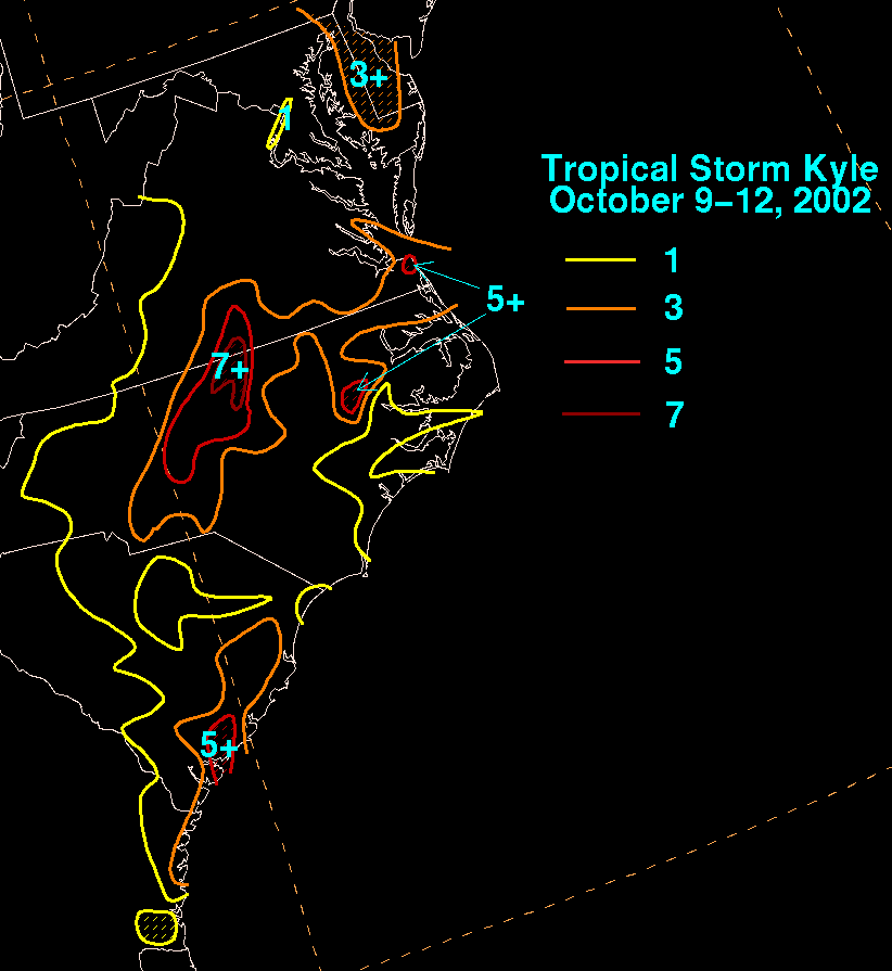
Moderate rainfall from Kyle in South Carolina peaked at 6.35 inches (161 mm) in Edisto Beach
, with the precipitation resulting in minor urban flooding. In and around St. Stephen
, flooding reached several feet in depth in roads and buildings; there, a nursing home had to be evacuated because of flooding. High waters in Manning
severely damaged 17 mobile homes, forcing about 50 people to move to shelters. Ten car accidents were reported in Florence
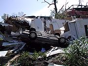
. The tropical storm spawned an F2
tornado
in Georgetown
that remained on the ground for about 1.25 miles (2 km). At its peak strength, the tornado overturned five mobile homes and a car. The tornado destroyed seven homes and damaged 106 buildings, 28 severely. Eight people were injured by the tornado.
 In North Carolina
, above-normal tides caused minor beach erosion. Rainfall near the coastline reached 5.6 inches (142 mm) in Greenville
. Moisture from the storm led to increased rainfall further inland, peaking at 8.72 inches (221 mm) in Butner
. Raleigh-Durham
recorded a two-day rainfall total of 5.79 inches (147 mm), which was the highest two-day total at the station since Hurricane Floyd
in 1999. Heavy rainfall caused flash flooding in Martin County
, where several roads were closed. Moderate winds were reported in the state, with gusts peaking at 49 mph (79 km/h) on Bald Head Island
. The storm spawned at least three tornadoes in the state, including an F2 twister near Pantego
that damaged two houses and a farm.
Moisture from Kyle extended into the Mid-Atlantic states and southern New York
. The precipitation alleviated rainfall deficits throughout the region. Overall damage amounted to about $5 million (2002 USD, $ USD). While no deaths were reported directly from Kyle, its remnants contributed to one death in stormy seas off the British Isles
.
with 27.25 days and Hurricane Inga
in the 1969 season
with 24.75 days. However, an update to the Atlantic hurricane best track in 2004 led to the San Ciriaco Hurricane
of 1899 to be re-analyzed
as the longest-lived Atlantic tropical cyclone on record, and as a result Kyle was dropped to the fourth longest-lived. Kyle was the only Atlantic tropical cyclone on record to attain tropical storm status on five occasions.
Atlantic hurricane
North Atlantic tropical cyclones usually form in the northern hemisphere summer or fall. Tropical cyclones can be categorized by intensity. Tropical storms have one-minute maximum sustained winds of at least 39 mph , while hurricanes have one-minute maximum sustained exceeding 74 mph...
tropical
Tropical cyclone
A tropical cyclone is a storm system characterized by a large low-pressure center and numerous thunderstorms that produce strong winds and heavy rain. Tropical cyclones strengthen when water evaporated from the ocean is released as the saturated air rises, resulting in condensation of water vapor...
or subtropical cyclone
Subtropical cyclone
A subtropical cyclone is a weather system that has some characteristics of a tropical and an extratropical cyclone. As early as the 1950s, meteorologists were unclear whether they should be characterized as tropical or extratropical cyclones. They were officially recognized by the National...
on record. The eleventh named storm and third hurricane of the 2002 Atlantic hurricane season
2002 Atlantic hurricane season
The 2002 Atlantic hurricane season was an average Atlantic hurricane season, officially starting on June 1, 2002 and ending on November 30, dates which conventionally limit the period of each year when tropical cyclones in the Atlantic Ocean tend to form...
, Kyle developed as a subtropical cyclone on September 20 to the east-southeast of Bermuda
Bermuda
Bermuda is a British overseas territory in the North Atlantic Ocean. Located off the east coast of the United States, its nearest landmass is Cape Hatteras, North Carolina, about to the west-northwest. It is about south of Halifax, Nova Scotia, Canada, and northeast of Miami, Florida...
. Looping westward, it transitioned into a tropical cyclone and became a hurricane on September 25. For the next two weeks, Kyle tracked generally westward, oscillating in strength several times because of fluctuations in environmental conditions. On October 11, the cyclone turned northeastward and made landfalls
Landfall (meteorology)
Landfall is the event of a tropical cyclone or a waterspout coming onto land after being over water. When a waterspout makes landfall it is reclassified as a tornado, which can then cause damage inland...
near Charleston, South Carolina
Charleston, South Carolina
Charleston is the second largest city in the U.S. state of South Carolina. It was made the county seat of Charleston County in 1901 when Charleston County was founded. The city's original name was Charles Towne in 1670, and it moved to its present location from a location on the west bank of the...
, and Long Beach, North Carolina
Long Beach, North Carolina
Long Beach, North Carolina is a coastal neighborhood that is incorporated into Oak Island, North Carolina in the year of 1955. Located on Oak Island, it is well known for the total devastation it sustained during Hurricane Hazel in 1954; only five of the 357 buildings survived the storm...
, at tropical storm status. After lasting as a cyclone for 22 days, Kyle dissipated on October 12 as it was absorbed by an approaching cold front.
The hurricane brought light precipitation to Bermuda, but no significant damage was reported there. Moderate rainfall accompanied its two landfalls in the United States, causing localized flash flooding and road closures. Floodwaters forced the evacuation of a nursing home and several mobile homes in South Carolina. Kyle spawned at least four tornadoes, the costliest of which struck Georgetown, South Carolina
Georgetown, South Carolina
Georgetown is the third oldest city in the U.S. state of South Carolina and the county seat of Georgetown County, in the Low Country. Located on Winyah Bay at the confluence of the Great Pee Dee River, Waccamaw River, and Sampit River, Georgetown is the second largest seaport in South Carolina,...
; it damaged 106 buildings and destroyed seven others, causing eight injuries. Overall damage totaled about $5 million (2002 USD, $ USD), and no direct deaths were reported. However, the remnants of Kyle contributed to one indirect death in the British Isles
British Isles
The British Isles are a group of islands off the northwest coast of continental Europe that include the islands of Great Britain and Ireland and over six thousand smaller isles. There are two sovereign states located on the islands: the United Kingdom of Great Britain and Northern Ireland and...
.
Meteorological history
A cold frontCold front
A cold front is defined as the leading edge of a cooler mass of air, replacing a warmer mass of air.-Development of cold front:The cooler and denser air wedges under the less-dense warmer air, lifting it...
stalled and began weakening to the southeast of Bermuda
Bermuda
Bermuda is a British overseas territory in the North Atlantic Ocean. Located off the east coast of the United States, its nearest landmass is Cape Hatteras, North Carolina, about to the west-northwest. It is about south of Halifax, Nova Scotia, Canada, and northeast of Miami, Florida...
on September 15, degenerating into a low pressure area
Low pressure area
A low-pressure area, or "low", is a region where the atmospheric pressure at sea level is below that of surrounding locations. Low-pressure systems form under areas of wind divergence which occur in upper levels of the troposphere. The formation process of a low-pressure area is known as...
by September 18. A stationary circulation developed by September 19, which was believed to have been aided by a trough
Trough (meteorology)
A trough is an elongated region of relatively low atmospheric pressure, often associated with fronts.Unlike fronts, there is not a universal symbol for a trough on a weather chart. The weather charts in some countries or regions mark troughs by a line. In the United States, a trough may be marked...
to its west. Convection
Convection
Convection is the movement of molecules within fluids and rheids. It cannot take place in solids, since neither bulk current flows nor significant diffusion can take place in solids....
developed into narrow banding features far from the center, and the overall structure gradually organized. It is estimated the system developed into Subtropical Depression Twelve late on September 20, about 825 miles (1330 km) southeast of Bermuda; it was classified subtropical because of the distance of the convection from the center. The cyclone tracked northward within the weak steering flow between an upper-level low to its south and a trough to its north. Strengthening gradually, the depression attained subtropical storm status early on September 21, and as such was named Kyle by the National Hurricane Center
National Hurricane Center
The National Hurricane Center , located at Florida International University in Miami, Florida, is the division of the National Weather Service responsible for tracking and predicting weather systems within the tropics between the Prime Meridian and the 140th meridian west poleward to the 30th...
.
After being named, Subtropical Storm Kyle tracked north-northeastward, gradually executing a clockwise loop. Initially, the circulation center remained partly exposed to the south and west of the deep convection. On September 22, convection increased around the center as the system developed a warm thermal core
Tropical cyclogenesis
Tropical cyclogenesis is the term that describes the development and strengthening of a tropical cyclone in the atmosphere. The mechanisms through which tropical cyclogenesis occurs are distinctly different from those through which mid-latitude cyclogenesis occurs...
, and as such it was re-classified as a tropical cyclone
Tropical cyclone
A tropical cyclone is a storm system characterized by a large low-pressure center and numerous thunderstorms that produce strong winds and heavy rain. Tropical cyclones strengthen when water evaporated from the ocean is released as the saturated air rises, resulting in condensation of water vapor...
. A building anticyclone
Anticyclone
An anticyclone is a weather phenomenon defined by the United States' National Weather Service's glossary as "[a] large-scale circulation of winds around a central region of high atmospheric pressure, clockwise in the Northern Hemisphere, counterclockwise in the Southern Hemisphere"...
to its northwest turned Kyle to the southwest. After briefly weakening, previously moderate wind shear
Wind shear
Wind shear, sometimes referred to as windshear or wind gradient, is a difference in wind speed and direction over a relatively short distance in the atmosphere...
began decreasing, which allowed convection to deepen and for outflow
Outflow (meteorology)
Outflow, in meteorology, is air that flows outwards from a storm system. It is associated with ridging, or anticyclonic flow. In the low levels of the troposphere, outflow radiates from thunderstorms in the form of a wedge of rain-cooled air, which is visible as a thin rope-like cloud on weather...
to further develop. Tracking over progressively warmer waters, Kyle began developing a banding eye feature
Eye (cyclone)
The eye is a region of mostly calm weather found at the center of strong tropical cyclones. The eye of a storm is a roughly circular area and typically 30–65 km in diameter. It is surrounded by the eyewall, a ring of towering thunderstorms where the second most severe weather of a cyclone...
late on September 24. Slow strengthening continued, and the storm attained hurricane status at 1200 UTC
Coordinated Universal Time
Coordinated Universal Time is the primary time standard by which the world regulates clocks and time. It is one of several closely related successors to Greenwich Mean Time. Computer servers, online services and other entities that rely on having a universally accepted time use UTC for that purpose...
on September 25. The next day, Kyle reached peak winds of 85 mph (130 km/h) about 490 miles (790 km/h) east-southeast of Bermuda.
Remaining a tropical depression for about 18 hours, Kyle re-intensified to tropical storm status on October 1, after redeveloping some thunderstorms southeast of the center. Despite unfavorable wind shear, the convection became better organized, developing into rain bands and wrapping into the mid-level circulation of the storm. Late on October 2, Kyle developed an eye feature in the center of the storm, and the winds increased to about 65 mph (105 km/h); operationally it was forecast to regain hurricane status. However, the storm encountered further wind shear, which left the center exposed from the convection by early on October 4. Convection became intermittent and separated from the circulation, and Kyle again weakened to tropical depression status on October 5. By then, the storm had begun a steady west-northwest motion, which was followed by a slow turn to the north-northeast. On October 6, a decrease in wind shear allowed the cyclone to again reach tropical storm status, about 295 miles (475 km) west-northwest of Bermuda. Around the same time, the system was located in an area of weak steering currents; a ridge was to its northeast and southwest, an upper-level low was to its east-southeast, and a broad trough was to its northwest. By October 7, it began a slow southwestward motion around a ridge to its west. The circulation became elongated as dry air limited convection, and after shear increased on October 8, Kyle weakened to tropical depression status.
By early on October 9, the depression consisted of a circulation center without any of the associated deep convection that is one of the prerequisites of being a tropical cyclone. Several hurricane forecast models predicted Kyle to weaken until dissipation
Dissipation
In physics, dissipation embodies the concept of a dynamical system where important mechanical models, such as waves or oscillations, lose energy over time, typically from friction or turbulence. The lost energy converts into heat, which raises the temperature of the system. Such systems are called...
. After 24 hours without significant convection, thunderstorms reformed to the southeast of the center on October 10 as the depression entered an area of warmer water temperatures. Environmental conditions became more favorable, with weakening wind shear and decreasing dry air. The depression continued tracking around a ridge, turning to the west and west-northwest toward the coast of Florida
Florida
Florida is a state in the southeastern United States, located on the nation's Atlantic and Gulf coasts. It is bordered to the west by the Gulf of Mexico, to the north by Alabama and Georgia and to the east by the Atlantic Ocean. With a population of 18,801,310 as measured by the 2010 census, it...
. Convection increased markedly early on October 11 as it turned northward ahead of an approaching cold front
Cold front
A cold front is defined as the leading edge of a cooler mass of air, replacing a warmer mass of air.-Development of cold front:The cooler and denser air wedges under the less-dense warmer air, lifting it...
, and Kyle regained tropical storm status about 35 miles (60 km) east of the border between Florida and Georgia
Georgia (U.S. state)
Georgia is a state located in the southeastern United States. It was established in 1732, the last of the original Thirteen Colonies. The state is named after King George II of Great Britain. Georgia was the fourth state to ratify the United States Constitution, on January 2, 1788...
.
Landfall (meteorology)
Landfall is the event of a tropical cyclone or a waterspout coming onto land after being over water. When a waterspout makes landfall it is reclassified as a tornado, which can then cause damage inland...
near McClellanville, South Carolina
McClellanville, South Carolina
McClellanville is a small fishing town in Charleston County, South Carolina, United States. The population was 459 at the 2000 census. It is situated on the Atlantic coast, on land surrounded by Francis Marion National Forest and has traditionally derived its livelihood from the sea and coastal...
as a minimal tropical storm. The storm briefly moved over open waters before again making landfall near Long Beach, North Carolina
Long Beach, North Carolina
Long Beach, North Carolina is a coastal neighborhood that is incorporated into Oak Island, North Carolina in the year of 1955. Located on Oak Island, it is well known for the total devastation it sustained during Hurricane Hazel in 1954; only five of the 357 buildings survived the storm...
late on October 11. By early on October 12, the storm had weakened to tropical depression status. At the time of it moving ashore, there was a separate non-tropical low to the northeast of the depression, and shear had greatly increased, which made re-intensification unlikely. However, convection redeveloped baroclinically
Baroclinity
In fluid dynamics, the baroclinity of a stratified fluid is a measure of how misaligned the gradient of pressure is from the gradient of density in a fluid...
with the approaching cold front, and Kyle attained tropical storm status for the fifth time over the eastern Pamlico Sound
Pamlico Sound
Pamlico Sound in North Carolina, is the largest lagoon along the U.S. East Coast, being long and 24 to 48 km wide. It is a body of water separated from the Atlantic Ocean by the Outer Banks, a row of low, sandy barrier islands, including Cape Hatteras. The Neuse and Pamlico rivers flow in...
. The restrengthening was short-lived, as the wind field expanded while the convection transitioned into that of a frontal band. After emerging into the western Atlantic Ocean, Tropical Storm Kyle merged with a cold front late on October 12. The remnants of Kyle continued eastward, executing a loop on October 14 before turning northeastward and impacting the Azores
Azores
The Archipelago of the Azores is composed of nine volcanic islands situated in the middle of the North Atlantic Ocean, and is located about west from Lisbon and about east from the east coast of North America. The islands, and their economic exclusion zone, form the Autonomous Region of the...
on October 17. The next day, the remnants of Kyle were absorbed by an extratropical cyclone
Extratropical cyclone
Extratropical cyclones, sometimes called mid-latitude cyclones or wave cyclones, are a group of cyclones defined as synoptic scale low pressure weather systems that occur in the middle latitudes of the Earth having neither tropical nor polar characteristics, and are connected with fronts and...
to its northwest, which continued northeastward and moved near the British Isles
British Isles
The British Isles are a group of islands off the northwest coast of continental Europe that include the islands of Great Britain and Ireland and over six thousand smaller isles. There are two sovereign states located on the islands: the United Kingdom of Great Britain and Northern Ireland and...
on October 23.
Preparations
Because of uncertainties in its track, the government of BermudaBermuda
Bermuda is a British overseas territory in the North Atlantic Ocean. Located off the east coast of the United States, its nearest landmass is Cape Hatteras, North Carolina, about to the west-northwest. It is about south of Halifax, Nova Scotia, Canada, and northeast of Miami, Florida...
posted a tropical storm watch
Tropical cyclone warnings and watches
Warnings and watches are two levels of alert issued by national weather forecasting bodies to coastal areas threatened by the imminent approach of a tropical cyclone of tropical storm or hurricane intensity. They are notices to the local population and civil authorities to make appropriate...
for the island on September 30; it was discontinued the following day.
As Kyle approached the coast of Florida, a tropical storm watch was issued between Cocoa Beach, Florida
Cocoa Beach, Florida
Cocoa Beach is a city in Brevard County, Florida, United States. The population was 12,482 at the 2000 census. According to the U.S. Census Bureau estimates of 2008, the city had a population of 11,920...
and Brunswick, Georgia
Brunswick, Georgia
Brunswick is the major urban and economic center in southeastern Georgia in the United States. The municipality is located on a harbor near the Atlantic Ocean, approximately 30 miles north of Florida and 70 miles south of South Carolina. Brunswick is bordered on the east by the Atlantic...
, and later was extended northward to Edisto Beach, South Carolina
Edisto Beach, South Carolina
Edisto Beach is a town in Colleton County, South Carolina, United States. The population was 641 at the 2000 census. The town limits include only the coastal area of Edisto Island .-History:Edisto Beach was originally settled by the Edisto Indians and was discovered...
. Early on October 11, a tropical storm warning was put in place between Brunswick, Georgia and Cape Fear, North Carolina, which was later amended to include the Pamlico Sound
Pamlico Sound
Pamlico Sound in North Carolina, is the largest lagoon along the U.S. East Coast, being long and 24 to 48 km wide. It is a body of water separated from the Atlantic Ocean by the Outer Banks, a row of low, sandy barrier islands, including Cape Hatteras. The Neuse and Pamlico rivers flow in...
and the coastline through Surf City, North Carolina
Surf City, North Carolina
Surf City is a town in Pender and Onslow counties in the U.S. state of North Carolina. The population was 2,057 at the 2008 census. It is located on Topsail Island....
. Prior to it making landfall, the National Weather Service
National Weather Service
The National Weather Service , once known as the Weather Bureau, is one of the six scientific agencies that make up the National Oceanic and Atmospheric Administration of the United States government...
office in Wilmington, North Carolina
Wilmington, North Carolina
Wilmington is a port city in and is the county seat of New Hanover County, North Carolina, United States. The population is 106,476 according to the 2010 Census, making it the eighth most populous city in the state of North Carolina...
issued a flood watch for much of the coastline that was ultimately affected; in South Carolina, a flood warning was issued for the counties of Florence
Florence County, South Carolina
Florence is a county located in the U.S. state of South Carolina. In 2000, its population was recorded to be 125,761; in 2005, the U.S. Census Bureau estimated that its population had reached 131,097. Its county seat is Florence. The county's population is about 60% urban and it comprises part of...
, Williamsburg, and Georgetown. States of emergencies were declared for ten South Carolina counties.
Impact
Bermuda
Bermuda is a British overseas territory in the North Atlantic Ocean. Located off the east coast of the United States, its nearest landmass is Cape Hatteras, North Carolina, about to the west-northwest. It is about south of Halifax, Nova Scotia, Canada, and northeast of Miami, Florida...
, the combination of the storm and a cold front to its north produced 2.19 inches (55.6 mm) of rainfall in the first two days of October, which was about half of the monthly rainfall total.
While passing near the northeast coast of Florida, Kyle produced a storm surge
Storm surge
A storm surge is an offshore rise of water associated with a low pressure weather system, typically tropical cyclones and strong extratropical cyclones. Storm surges are caused primarily by high winds pushing on the ocean's surface. The wind causes the water to pile up higher than the ordinary sea...
of 1.31 feet (0.4 m) in Fernandina Beach
Fernandina Beach, Florida
Fernandina Beach is a city in Nassau County in the state of Florida in the United States of America and on Amelia Island. It is a part of Greater Jacksonville and is among Florida's northernmost cities. The area was first inhabited by the Timucuan Indian tribe...
. Winds were light, with gusts peaking at 32 mph (52 km/h) in St. Augustine, and precipitation reached 2.05 inches (52 mm) in Fernandina Beach. Along the Georgia
Georgia (U.S. state)
Georgia is a state located in the southeastern United States. It was established in 1732, the last of the original Thirteen Colonies. The state is named after King George II of Great Britain. Georgia was the fourth state to ratify the United States Constitution, on January 2, 1788...
coastline, the storm dropped moderate rainfall that peaked at 5.35 inches (136 mm) at Hunter Army Airfield
Hunter Army Airfield
Hunter Army Airfield , located in Savannah, Georgia, United States, is a military airfield and subordinate installation to Fort Stewart.Hunter features a runway that is 11,375 feet long and an aircraft parking area that is more than 350 acres...
. Most of the precipitation fell in a 12 hour period, which flooded roads and low-lying areas; several roads were closed, and numerous vehicles stalled in the floodwaters.
Moderate rainfall from Kyle in South Carolina peaked at 6.35 inches (161 mm) in Edisto Beach
Edisto Beach, South Carolina
Edisto Beach is a town in Colleton County, South Carolina, United States. The population was 641 at the 2000 census. The town limits include only the coastal area of Edisto Island .-History:Edisto Beach was originally settled by the Edisto Indians and was discovered...
, with the precipitation resulting in minor urban flooding. In and around St. Stephen
St. Stephen, South Carolina
St. Stephen is a town in Berkeley County, South Carolina, United States. The population was 1,776 at the 2000 census.As defined by the U.S. Office of Management and Budget, and used by the U.S. Census Bureau for statistical purposes only, St. Stephen is included within the Charleston-North...
, flooding reached several feet in depth in roads and buildings; there, a nursing home had to be evacuated because of flooding. High waters in Manning
Manning, South Carolina
Manning is a city in South Carolina and the county seat of Clarendon County in the Southeastern United States, located in the center of the county, just to the east of Interstate 95 and at the intersection of U.S. 301 and U.S. 521. The population was estimated to be 3,943 as of 2008, down 2% from...
severely damaged 17 mobile homes, forcing about 50 people to move to shelters. Ten car accidents were reported in Florence
Florence, South Carolina
-Municipal government and politics:The City of Florence has a council-manager form of government. The mayor and city council are elected every four years, with no term limits...
. The tropical storm spawned an F2
Fujita scale
The Fujita scale , or Fujita-Pearson scale, is a scale for rating tornado intensity, based primarily on the damage tornadoes inflict on human-built structures and vegetation...
tornado
Tornado
A tornado is a violent, dangerous, rotating column of air that is in contact with both the surface of the earth and a cumulonimbus cloud or, in rare cases, the base of a cumulus cloud. They are often referred to as a twister or a cyclone, although the word cyclone is used in meteorology in a wider...
in Georgetown
Georgetown, South Carolina
Georgetown is the third oldest city in the U.S. state of South Carolina and the county seat of Georgetown County, in the Low Country. Located on Winyah Bay at the confluence of the Great Pee Dee River, Waccamaw River, and Sampit River, Georgetown is the second largest seaport in South Carolina,...
that remained on the ground for about 1.25 miles (2 km). At its peak strength, the tornado overturned five mobile homes and a car. The tornado destroyed seven homes and damaged 106 buildings, 28 severely. Eight people were injured by the tornado.
North Carolina
North Carolina is a state located in the southeastern United States. The state borders South Carolina and Georgia to the south, Tennessee to the west and Virginia to the north. North Carolina contains 100 counties. Its capital is Raleigh, and its largest city is Charlotte...
, above-normal tides caused minor beach erosion. Rainfall near the coastline reached 5.6 inches (142 mm) in Greenville
Greenville, North Carolina
Greenville is the county seat of Pitt County and principal city of the Greenville, North Carolina metropolitan area. Greenville is the health, entertainment, and educational hub of North Carolina's Tidewater and Coastal Plain and in 2008 was listed as the Tenth Largest City in North Carolina...
. Moisture from the storm led to increased rainfall further inland, peaking at 8.72 inches (221 mm) in Butner
Butner, North Carolina
Butner is a town in Granville County, North Carolina, United States. The population was 7,591 at the 2010 census]. Butner was managed by the state of North Carolina from 1947 through 2007. A bill passed by the North Carolina General Assembly incorporating the town was signed by Gov. Mike Easley on...
. Raleigh-Durham
The Triangle (North Carolina)
The Research Triangle, also known as Raleigh-Durham and commonly referred to as simply "The Triangle", is a region in the Piedmont of North Carolina in the United States, anchored by North Carolina State University, Duke University, University of North Carolina at Chapel Hill, and cities of...
recorded a two-day rainfall total of 5.79 inches (147 mm), which was the highest two-day total at the station since Hurricane Floyd
Hurricane Floyd
Hurricane Floyd was the sixth named storm, fourth hurricane, and third major hurricane in the 1999 Atlantic hurricane season. Floyd triggered the third largest evacuation in US history when 2.6 million coastal residents of five states were ordered from their homes as it approached...
in 1999. Heavy rainfall caused flash flooding in Martin County
Martin County, North Carolina
-Politics:Martin County has tended to vote in line with the rest of the country in presidential elections. In 2008, Barack Obama won the county with 52.2% of the vote. This was very similar to his national figure of 52.91%.-Demographics:...
, where several roads were closed. Moderate winds were reported in the state, with gusts peaking at 49 mph (79 km/h) on Bald Head Island
Bald Head Island, North Carolina
Bald Head Island is a village located on the east side of the Cape Fear River in Brunswick County, North Carolina, United States. Compared to the city of Wilmington to the north, the village of Bald Head Island is small and somewhat remote. It is only accessible by ferry from the nearby town of...
. The storm spawned at least three tornadoes in the state, including an F2 twister near Pantego
Pantego, North Carolina
Pantego is a town in Beaufort County, North Carolina, United States. The population was 170 at the 2000 census.-Geography:Pantego is located at ....
that damaged two houses and a farm.
Moisture from Kyle extended into the Mid-Atlantic states and southern New York
New York
New York is a state in the Northeastern region of the United States. It is the nation's third most populous state. New York is bordered by New Jersey and Pennsylvania to the south, and by Connecticut, Massachusetts and Vermont to the east...
. The precipitation alleviated rainfall deficits throughout the region. Overall damage amounted to about $5 million (2002 USD, $ USD). While no deaths were reported directly from Kyle, its remnants contributed to one death in stormy seas off the British Isles
British Isles
The British Isles are a group of islands off the northwest coast of continental Europe that include the islands of Great Britain and Ireland and over six thousand smaller isles. There are two sovereign states located on the islands: the United Kingdom of Great Britain and Northern Ireland and...
.
Records
Lasting for a total of 22 days, Hurricane Kyle was operationally considered the third longest-lived tropical cyclone in the Atlantic basin; Kyle was behind Hurricane Ginger in the 1971 season1971 Atlantic hurricane season
The 1971 Atlantic hurricane season was fairly active with several notable storms. Hurricane Edith, the strongest of the season, was a Category 5 on the Saffir-Simpson scale, the highest category on the scale. It struck Nicaragua at peak intensity, killing dozens, and later hit southern Louisiana...
with 27.25 days and Hurricane Inga
Hurricane Inga (1969)
Hurricane Inga is the third longest-lived Atlantic hurricane on record. The 11th tropical cyclone and 9th named storm of the 1969 Atlantic hurricane season, Inga developed on September 20 in the central Atlantic and tracked westward. After attaining tropical storm status, the system deteriorated...
in the 1969 season
1969 Atlantic hurricane season
The 1969 Atlantic hurricane season officially began on June 1, 1969, and lasted until November 30, 1969. These dates conventionally delimit the period of each year when most tropical cyclones form in the Atlantic basin. The season was among the most active on record, with 18 tropical cyclones, 12...
with 24.75 days. However, an update to the Atlantic hurricane best track in 2004 led to the San Ciriaco Hurricane
1899 Hurricane San Ciriaco
1899 San Ciriaco hurricane, also known as the 1899 Puerto Rico Hurricane, was the longest-lived Atlantic hurricane and the eleventh deadliest tropical cyclone in the basin. It was an intense and long-lived Atlantic Cape Verde-type hurricane which crossed Puerto Rico over the two day period August 8...
of 1899 to be re-analyzed
Atlantic hurricane reanalysis
Atlantic hurricane reanalysis is an ongoing project within the National Oceanic and Atmospheric Administration which seeks to correct and add new information about past Atlantic tropical cyclones...
as the longest-lived Atlantic tropical cyclone on record, and as a result Kyle was dropped to the fourth longest-lived. Kyle was the only Atlantic tropical cyclone on record to attain tropical storm status on five occasions.
See also
- Other tropical cyclones named Kyle
- List of tropical cyclones
- List of Florida hurricanes (2000–present)
- List of North Carolina hurricanes (1980–present)