
Surf City, North Carolina
Encyclopedia
Surf City is a town in Pender
and Onslow
counties in the U.S. state
of North Carolina
. The population was 2,057 at the 2008 census. It is located on Topsail Island
.
The Onslow County portion of Surf City is part of the Jacksonville
Metropolitan Statistical Area
, while the Pender County portion is part of the Wilmington
Metropolitan Statistical Area.
According to the United States Census Bureau
, the town has a total area of 5.3 square miles (13.7 km²).4.2 square miles (10.9 km²) of it is land and 1.1 square miles (2.8 km²) of it (20.45%) is water.
Recent annexations have extended the Town limits on the mainland to highway 17.
of 2000, there were 1,393 people, 689 households, and 403 families residing in the town. The population density
was 331.6 people per square mile (128.1/km²). There were 2,578 housing units at an average density of 613.7 per square mile (237.0/km²). The racial makeup of the town was 97.77% White, 0.43% African American, 0.07% Native American, 0.72% Asian, 0.14% Pacific Islander, 0.22% from other races
, and 0.65% from two or more races. Hispanic or Latino of any race were 1.01% of the population.
There were 689 households out of which 12.6% had children under the age of 18 living with them, 51.5% were married couples
living together, 4.9% had a female householder with no husband present, and 41.4% were non-families. 32.4% of all households were made up of individuals and 7.7% had someone living alone who was 65 years of age or older. The average household size was 2.02 and the average family size was 2.51.
In the town the population was spread out with 12.6% under the age of 18, 6.2% from 18 to 24, 25.4% from 25 to 44, 39.6% from 45 to 64, and 16.3% who were 65 years of age or older. The median age was 48 years. For every 100 females there were 102.2 males. For every 100 females age 18 and over, there were 104.7 males.
The median income for a household in the town was $40,521, and the median income for a family was $48,854. Males had a median income of $36,600 versus $30,000 for females. The per capita income
for the town was $25,242. About 9.9% of families and 15.4% of the population were below the poverty line, including 43.3% of those under age 18 and 3.9% of those age 65 or over.
Pender County, North Carolina
-Demographics:As of the census of 2000, there were 41,082 people, 16,054 households, and 11,719 families residing in the county. The population density was 47 people per square mile . There were 20,798 housing units at an average density of 24 per square mile...
and Onslow
Onslow County, North Carolina
-Demographics:As of the census of 2000, there were 150,355 people, 48,122 households, and 36,572 families residing in the county. The population density was 196 people per square mile . There were 55,726 housing units at an average density of 73 per square mile...
counties in the U.S. state
U.S. state
A U.S. state is any one of the 50 federated states of the United States of America that share sovereignty with the federal government. Because of this shared sovereignty, an American is a citizen both of the federal entity and of his or her state of domicile. Four states use the official title of...
of North Carolina
North Carolina
North Carolina is a state located in the southeastern United States. The state borders South Carolina and Georgia to the south, Tennessee to the west and Virginia to the north. North Carolina contains 100 counties. Its capital is Raleigh, and its largest city is Charlotte...
. The population was 2,057 at the 2008 census. It is located on Topsail Island
Topsail Island
Topsail Island is a 26-mile long barrier island off the coast of North Carolina, USA just south of Camp Lejeune, the Bogue Banks, and the Outer Banks. It contains the communities of North Topsail Beach, Surf City and Topsail Beach. Along with its thick maritime forests, Topsail Island is also a...
.
The Onslow County portion of Surf City is part of the Jacksonville
Jacksonville, North Carolina
Jacksonville, North Carolina, is a city in Onslow County, North Carolina, United States. As of the 2010 United States census, the population stood at 70,145, which makes Jacksonville the 14th largest city in North Carolina...
Metropolitan Statistical Area
Jacksonville, North Carolina metropolitan area
The Jacksonville Metropolitan Statistical Area, as defined by the United States Census Bureau, is an area consisting of one county – Onslow – in North Carolina, anchored by the city of Jacksonville...
, while the Pender County portion is part of the Wilmington
Wilmington, North Carolina
Wilmington is a port city in and is the county seat of New Hanover County, North Carolina, United States. The population is 106,476 according to the 2010 Census, making it the eighth most populous city in the state of North Carolina...
Metropolitan Statistical Area.
Geography
Surf City is located at 34°25′41"N 77°32′36"W (34.428137, -77.543198).According to the United States Census Bureau
United States Census Bureau
The United States Census Bureau is the government agency that is responsible for the United States Census. It also gathers other national demographic and economic data...
, the town has a total area of 5.3 square miles (13.7 km²).4.2 square miles (10.9 km²) of it is land and 1.1 square miles (2.8 km²) of it (20.45%) is water.
Recent annexations have extended the Town limits on the mainland to highway 17.
Demographics
As of the censusCensus
A census is the procedure of systematically acquiring and recording information about the members of a given population. It is a regularly occurring and official count of a particular population. The term is used mostly in connection with national population and housing censuses; other common...
of 2000, there were 1,393 people, 689 households, and 403 families residing in the town. The population density
Population density
Population density is a measurement of population per unit area or unit volume. It is frequently applied to living organisms, and particularly to humans...
was 331.6 people per square mile (128.1/km²). There were 2,578 housing units at an average density of 613.7 per square mile (237.0/km²). The racial makeup of the town was 97.77% White, 0.43% African American, 0.07% Native American, 0.72% Asian, 0.14% Pacific Islander, 0.22% from other races
Race (United States Census)
Race and ethnicity in the United States Census, as defined by the Federal Office of Management and Budget and the United States Census Bureau, are self-identification data items in which residents choose the race or races with which they most closely identify, and indicate whether or not they are...
, and 0.65% from two or more races. Hispanic or Latino of any race were 1.01% of the population.
There were 689 households out of which 12.6% had children under the age of 18 living with them, 51.5% were married couples
Marriage
Marriage is a social union or legal contract between people that creates kinship. It is an institution in which interpersonal relationships, usually intimate and sexual, are acknowledged in a variety of ways, depending on the culture or subculture in which it is found...
living together, 4.9% had a female householder with no husband present, and 41.4% were non-families. 32.4% of all households were made up of individuals and 7.7% had someone living alone who was 65 years of age or older. The average household size was 2.02 and the average family size was 2.51.
In the town the population was spread out with 12.6% under the age of 18, 6.2% from 18 to 24, 25.4% from 25 to 44, 39.6% from 45 to 64, and 16.3% who were 65 years of age or older. The median age was 48 years. For every 100 females there were 102.2 males. For every 100 females age 18 and over, there were 104.7 males.
The median income for a household in the town was $40,521, and the median income for a family was $48,854. Males had a median income of $36,600 versus $30,000 for females. The per capita income
Per capita income
Per capita income or income per person is a measure of mean income within an economic aggregate, such as a country or city. It is calculated by taking a measure of all sources of income in the aggregate and dividing it by the total population...
for the town was $25,242. About 9.9% of families and 15.4% of the population were below the poverty line, including 43.3% of those under age 18 and 3.9% of those age 65 or over.
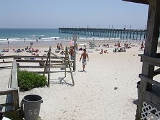
Piers (from west to east)
- Surf City
- Barnacle Bill's (destroyed by Hurricane FranHurricane FranHurricane Fran was a powerful Cape Verde-type hurricane of the 1996 Atlantic hurricane season that made landfall near Cape Fear in North Carolina at Category 3 strength. Throughout the eastern United States, early statistics on Fran reported 27 deaths and $3.2 billion in damage...
) - Scotch Bonnet (destroyed by Hurricane FranHurricane FranHurricane Fran was a powerful Cape Verde-type hurricane of the 1996 Atlantic hurricane season that made landfall near Cape Fear in North Carolina at Category 3 strength. Throughout the eastern United States, early statistics on Fran reported 27 deaths and $3.2 billion in damage...
) - Ocean City (destroyed by Hurricane FranHurricane FranHurricane Fran was a powerful Cape Verde-type hurricane of the 1996 Atlantic hurricane season that made landfall near Cape Fear in North Carolina at Category 3 strength. Throughout the eastern United States, early statistics on Fran reported 27 deaths and $3.2 billion in damage...
)