

Hurricane Ginny
Encyclopedia
Hurricane Ginny in the 1963 Atlantic hurricane season
was the latest Atlantic hurricane
on record to affect the U.S. state
of Maine
. It developed on October 16 over the Bahamas, although it was not initially a fully tropical cyclone
. As it moved to the north and later northwest, Ginny intensified to hurricane status as it became more tropical. For eight days, it was located within 250 mi (402.3 km) of the United States coastline. After approaching North Carolina, Ginny looped to the southwest and approached within 50 mi (80.5 km) of the Florida coastline. It turned to the north, to the east, and later to the northeast, strengthening late in its duration to peak winds of 110 mph (175 km/h). Ginny became an extratropical cyclone
shortly before striking Nova Scotia
on October 29.
Although it remained close to the United States coastline, its impact was minor. Beach erosion and light rainfall was reported along much of the coastline, although the precipitation was beneficial in ending droughts in South Carolina and New England. High waves destroyed one house in North Carolina. Damage was heaviest in New England, where several buildings were damaged and thousands were left without power. The passage of Ginny resulted in a snow storm across eastern New England, particularly in northern Maine, where it killed two people. In Atlantic Canada, the extratropical storm produced high wind and waves, causing damage to boats and resulting in power outages.
that extended from the Bahamas to Bermuda
in the middle of October. On October 16, a depression formed near the Turks and Caicos islands after a tropical wave
interacted with the trough, although initially it was not tropical
in nature due to the widespread presence of cold air. The system initially moved generally northward, attaining gale–force winds on October 19 as it turned to the northwest. For several days, Ginny maintained a hybrid-type structure
, and although it attained winds of 75 mph (120.7 km/h) on October 20, it was not a true hurricane. It closely approached the North Carolina coastline, passing 135 mi (220 km) southeast of Cape Lookout
before turning abruptly to the northeast. It executed a small loop and began a steady motion to the southeast while located over the Gulf Stream
. This motion was due to a large ridge
located over New England
. On October 21, the hurricane became better organized and began transitioning
into a tropical cyclone. By early on October 22, Hurricane Hunters
indicated that Ginny completed the transition into a fully tropical cyclone, observing an eye
20 mi (32 km) in diameter.
On October 23, Ginny briefly weakened to tropical storm status as it was moving toward Florida, although within 10 hours it regained hurricane intensity. Its motion to the southwest was unusual but not unique, and resembled the tracks of the 1935 Yankee hurricane
and Hurricane Able
in 1951. On October 24, it turned sharply northeastward off the northeast Florida coast, coming within 50 mi (80.5 km) of Daytona Beach
. The hurricane continued paralleling the coast of the Southeastern United States, turning northeast away from Georgia
and South Carolina
. On October 26, Ginny turned to the east away from the United States, having been located within 250 mi (402.3 km) of the country's coast for eight consecutive days. The next day, the hurricane began a motion to the northeast, accelerating in advance of an approaching trough
. It gradually intensified, reaching peak winds of 110 mph (175 km/h) on October 29. Later that day, Ginny became extratropical
before making landfall
on southwestern Nova Scotia
; its remnants dissipated on October 30 in the Gulf of Saint Lawrence
.
 Early in its duration, the precursor to Ginny dropped high amounts of rainfall. Monción
in the Dominican Republic
reported 6.83 in (173.5 mm), and Green Turtle Cay
in the Bahamas reported 4.2 in (106.7 mm).
Despite Ginny's proximity to the United States for over a week, a hurricane warning
was only issued from Charleston, South Carolina
and Cape Fear, North Carolina, as well as Cape Hatteras
. This represented about one-sixth of the entire coastline that was threatened by the storm. In Jacksonville, Florida
, Ginny produced winds of 40 mph (64.4 km/h). Rainfall in the state peaked at 1.32 in (33.5 mm) at Saint Augustine. Tides in Daytona Beach were 3 ft (0.9144 m) above normal, which caused beach erosion and minor property damage. Further north, minor damage and beach erosion was likewise reported in Georgia. Along the South Carolina coast, Ginny dropped beneficial rainfall, which alleviated the state's worst drought conditions on record. The rainfall peaked at 5.06 in (128.5 mm) in Isle of Pines.
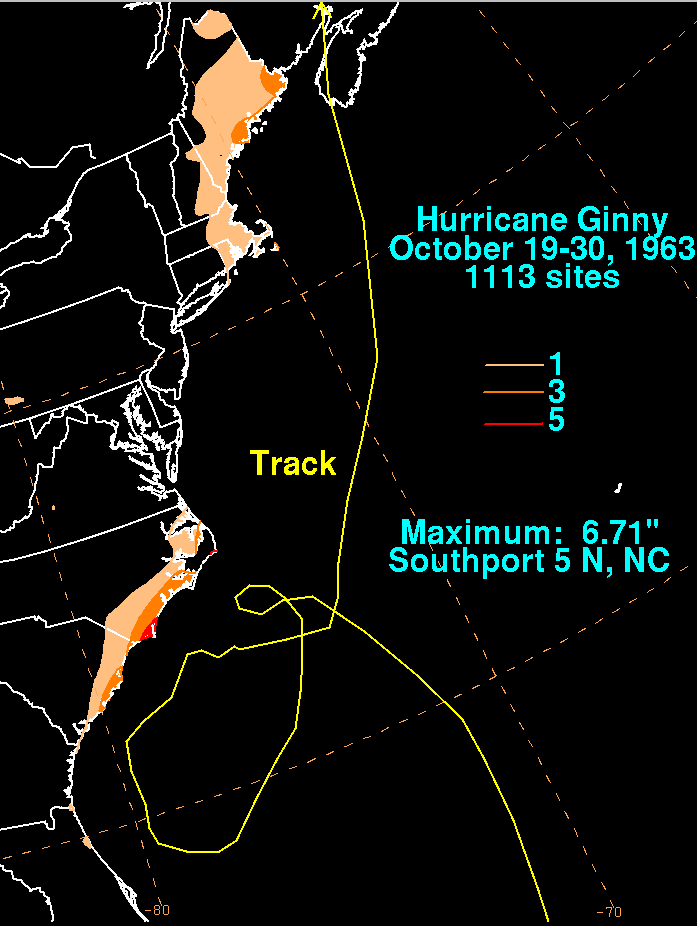
The hurricane approached North Carolina twice. During the second time, residents in low-lying areas and along the coast evacuated. As it passed the area, Ginny produced sustained winds that were estimated at 70 mph (112.7 km/h) on Cape Fear, with gusts to 100 mph (160 km/h). These were the highest winds related to the hurricane, although they may have been over-estimated. In addition, the heaviest rainfall related to the storm occurred near Southport
, where 6.71 in (170.4 mm) of precipitation fell. Tides along the coast were 4 ft (1.2 m) above normal, which caused minor flooding and destroyed one house in Carolina Beach
. In Virginia, the hurricane caused minor flooding and minimal beach erosion. During Ginny's first approach through the region, it produced gale force winds along the Virginia coast, although it did not do so during its second approach.
Later, a gale warning was issued for New England due to Ginny's threat, as well as a hurricane watch for Long Island
and southern New England. Across the region, the strongest winds on land were 65 mph (104.6 km/h) along Nantucket, where a gust of 76 mph (122.3 km/h) was also reported. However, a boat offshore Portland, Maine
reported 40 ft (12.2 m) seas and winds of at least 105 mph (169 km/h). In New York City
, the outskirts of the storm dropped 0.1 in (2.5 mm) of precipitation, and tides were 1 ft (0.3048 m) above normal. Rainfall in eastern New England surpassed 1 in (25.4 mm), peaking at 3.92 in (99.6 mm) in Machias, Maine. The rainfall was beneficial across the region, ending a 28–day drought. Along Cape Cod
and in Maine, high winds from the storm downed several trees, some of which fell onto power lines. About 1,000 homes in Chatham, Massachusetts
lost power. In Nantucket, high waves caused additional erosion in an area affected by Hurricane Esther
two years prior. Damage was heavier in Maine, where many boats were damaged or broke from their moorings. One person died from a heart attack while trying to rescue his boat. Several small buildings in the state were destroyed, and the post office in Calais, Maine
lost its roof. Ginny was the latest hurricane on record to affect Maine., During its passage, Ginny brought an influx of cold air over New England that produced the first snowfall of the season across Massachusetts, Maine, and New Hampshire. In most locations, the snow quickly melted, although higher totals occurred in northern Maine, the highest being 4 ft (1.2 m) on Mount Katahdin
. The snow killed a mountain climber and a park ranger. Damage from Ginny in the United States was estimated at $400,000.
As the remnants of Ginny moved across Atlantic Canada, they produced heavy rainfall, peaking at 4.53 in (113 mm) in southern New Brunswick
. Winds peaked at 99 mph (160 km/h) in Greenwood, Nova Scotia. The winds blew down trees in the Halifax area, and there were power outages reported there and in Antigonish
. High waves broke boats from their moorings, causing them to either wash ashore or float out to sea. Ferry service across the region was canceled. In neighboring New Brunswick, the storm caused outages to telephone and electric services. Several injuries were reported, although there were no fatalities. The entirety of Prince Edward Island
was also left without power.
episode "Unscheduled Departure" when the crew flies through the storm while flying from New York
to Caracas, Venezuela.
1963 Atlantic hurricane season
The 1963 Atlantic hurricane season was a below average Atlantic hurricane season, with nine named storms. Although the season officially began on June 1, the first storm did not form until nearly a month later. Hurricane Cindy made landfall in Texas before dissipating in the southern portion of the...
was the latest Atlantic hurricane
Atlantic hurricane
North Atlantic tropical cyclones usually form in the northern hemisphere summer or fall. Tropical cyclones can be categorized by intensity. Tropical storms have one-minute maximum sustained winds of at least 39 mph , while hurricanes have one-minute maximum sustained exceeding 74 mph...
on record to affect the U.S. state
U.S. state
A U.S. state is any one of the 50 federated states of the United States of America that share sovereignty with the federal government. Because of this shared sovereignty, an American is a citizen both of the federal entity and of his or her state of domicile. Four states use the official title of...
of Maine
Maine
Maine is a state in the New England region of the northeastern United States, bordered by the Atlantic Ocean to the east and south, New Hampshire to the west, and the Canadian provinces of Quebec to the northwest and New Brunswick to the northeast. Maine is both the northernmost and easternmost...
. It developed on October 16 over the Bahamas, although it was not initially a fully tropical cyclone
Tropical cyclone
A tropical cyclone is a storm system characterized by a large low-pressure center and numerous thunderstorms that produce strong winds and heavy rain. Tropical cyclones strengthen when water evaporated from the ocean is released as the saturated air rises, resulting in condensation of water vapor...
. As it moved to the north and later northwest, Ginny intensified to hurricane status as it became more tropical. For eight days, it was located within 250 mi (402.3 km) of the United States coastline. After approaching North Carolina, Ginny looped to the southwest and approached within 50 mi (80.5 km) of the Florida coastline. It turned to the north, to the east, and later to the northeast, strengthening late in its duration to peak winds of 110 mph (175 km/h). Ginny became an extratropical cyclone
Extratropical cyclone
Extratropical cyclones, sometimes called mid-latitude cyclones or wave cyclones, are a group of cyclones defined as synoptic scale low pressure weather systems that occur in the middle latitudes of the Earth having neither tropical nor polar characteristics, and are connected with fronts and...
shortly before striking Nova Scotia
Nova Scotia
Nova Scotia is one of Canada's three Maritime provinces and is the most populous province in Atlantic Canada. The name of the province is Latin for "New Scotland," but "Nova Scotia" is the recognized, English-language name of the province. The provincial capital is Halifax. Nova Scotia is the...
on October 29.
Although it remained close to the United States coastline, its impact was minor. Beach erosion and light rainfall was reported along much of the coastline, although the precipitation was beneficial in ending droughts in South Carolina and New England. High waves destroyed one house in North Carolina. Damage was heaviest in New England, where several buildings were damaged and thousands were left without power. The passage of Ginny resulted in a snow storm across eastern New England, particularly in northern Maine, where it killed two people. In Atlantic Canada, the extratropical storm produced high wind and waves, causing damage to boats and resulting in power outages.
Meteorological history
The origins of Hurricane Ginny were from a troughTrough (meteorology)
A trough is an elongated region of relatively low atmospheric pressure, often associated with fronts.Unlike fronts, there is not a universal symbol for a trough on a weather chart. The weather charts in some countries or regions mark troughs by a line. In the United States, a trough may be marked...
that extended from the Bahamas to Bermuda
Bermuda
Bermuda is a British overseas territory in the North Atlantic Ocean. Located off the east coast of the United States, its nearest landmass is Cape Hatteras, North Carolina, about to the west-northwest. It is about south of Halifax, Nova Scotia, Canada, and northeast of Miami, Florida...
in the middle of October. On October 16, a depression formed near the Turks and Caicos islands after a tropical wave
Tropical wave
Tropical waves, easterly waves, or tropical easterly waves, also known as African easterly waves in the Atlantic region, are a type of atmospheric trough, an elongated area of relatively low air pressure, oriented north to south, which move from east to west across the tropics causing areas of...
interacted with the trough, although initially it was not tropical
Tropical cyclone
A tropical cyclone is a storm system characterized by a large low-pressure center and numerous thunderstorms that produce strong winds and heavy rain. Tropical cyclones strengthen when water evaporated from the ocean is released as the saturated air rises, resulting in condensation of water vapor...
in nature due to the widespread presence of cold air. The system initially moved generally northward, attaining gale–force winds on October 19 as it turned to the northwest. For several days, Ginny maintained a hybrid-type structure
Subtropical cyclone
A subtropical cyclone is a weather system that has some characteristics of a tropical and an extratropical cyclone. As early as the 1950s, meteorologists were unclear whether they should be characterized as tropical or extratropical cyclones. They were officially recognized by the National...
, and although it attained winds of 75 mph (120.7 km/h) on October 20, it was not a true hurricane. It closely approached the North Carolina coastline, passing 135 mi (220 km) southeast of Cape Lookout
Cape Lookout (North Carolina)
This article is about the Cape Lookout in North Carolina. See Cape Lookout for other places with a similar name. Cape Lookout is southern point of the Core Banks, one of the natural barrier islands on the Atlantic coast of North Carolina, USA. delimits Onslow Bay to the west from Raleigh Bay to...
before turning abruptly to the northeast. It executed a small loop and began a steady motion to the southeast while located over the Gulf Stream
Gulf Stream
The Gulf Stream, together with its northern extension towards Europe, the North Atlantic Drift, is a powerful, warm, and swift Atlantic ocean current that originates at the tip of Florida, and follows the eastern coastlines of the United States and Newfoundland before crossing the Atlantic Ocean...
. This motion was due to a large ridge
Ridge (meteorology)
A ridge is an elongated region of relatively high atmospheric pressure, the opposite of a trough....
located over New England
New England
New England is a region in the northeastern corner of the United States consisting of the six states of Maine, New Hampshire, Vermont, Massachusetts, Rhode Island, and Connecticut...
. On October 21, the hurricane became better organized and began transitioning
Tropical cyclogenesis
Tropical cyclogenesis is the term that describes the development and strengthening of a tropical cyclone in the atmosphere. The mechanisms through which tropical cyclogenesis occurs are distinctly different from those through which mid-latitude cyclogenesis occurs...
into a tropical cyclone. By early on October 22, Hurricane Hunters
Hurricane Hunters
The Hurricane Hunters are aircraft that fly into tropical cyclones in the North Atlantic Ocean and Northeastern Pacific Ocean for the specific purpose of directly measuring weather data in and around those storms. In the United States, the Air Force, Navy, and NOAA units have all participated in...
indicated that Ginny completed the transition into a fully tropical cyclone, observing an eye
Eye (cyclone)
The eye is a region of mostly calm weather found at the center of strong tropical cyclones. The eye of a storm is a roughly circular area and typically 30–65 km in diameter. It is surrounded by the eyewall, a ring of towering thunderstorms where the second most severe weather of a cyclone...
20 mi (32 km) in diameter.
On October 23, Ginny briefly weakened to tropical storm status as it was moving toward Florida, although within 10 hours it regained hurricane intensity. Its motion to the southwest was unusual but not unique, and resembled the tracks of the 1935 Yankee hurricane
1935 Yankee hurricane
The Yankee Hurricane of 1935 was a rare Category 1 hurricane that affected the Bahamas and South Florida in November. It remains the only tropical cyclone to affect Miami from the northeast in November. The sixth tropical cyclone and fifth hurricane of the 1935 Atlantic hurricane season, it...
and Hurricane Able
Hurricane Able (1951)
Hurricane Able was the strongest recorded hurricane outside of the typical Atlantic hurricane season. The first tropical cyclone in 1951, Able developed from a trough of low pressure on May 15 about 300 miles south of Bermuda...
in 1951. On October 24, it turned sharply northeastward off the northeast Florida coast, coming within 50 mi (80.5 km) of Daytona Beach
Daytona Beach, Florida
Daytona Beach is a city in Volusia County, Florida, USA. According to 2008 U.S. Census Bureau estimates, the city has a population of 64,211. Daytona Beach is a principal city of the Deltona – Daytona Beach – Ormond Beach, Florida Metropolitan Statistical Area, which the census bureau estimated had...
. The hurricane continued paralleling the coast of the Southeastern United States, turning northeast away from Georgia
Georgia (U.S. state)
Georgia is a state located in the southeastern United States. It was established in 1732, the last of the original Thirteen Colonies. The state is named after King George II of Great Britain. Georgia was the fourth state to ratify the United States Constitution, on January 2, 1788...
and South Carolina
South Carolina
South Carolina is a state in the Deep South of the United States that borders Georgia to the south, North Carolina to the north, and the Atlantic Ocean to the east. Originally part of the Province of Carolina, the Province of South Carolina was one of the 13 colonies that declared independence...
. On October 26, Ginny turned to the east away from the United States, having been located within 250 mi (402.3 km) of the country's coast for eight consecutive days. The next day, the hurricane began a motion to the northeast, accelerating in advance of an approaching trough
Trough (meteorology)
A trough is an elongated region of relatively low atmospheric pressure, often associated with fronts.Unlike fronts, there is not a universal symbol for a trough on a weather chart. The weather charts in some countries or regions mark troughs by a line. In the United States, a trough may be marked...
. It gradually intensified, reaching peak winds of 110 mph (175 km/h) on October 29. Later that day, Ginny became extratropical
Extratropical cyclone
Extratropical cyclones, sometimes called mid-latitude cyclones or wave cyclones, are a group of cyclones defined as synoptic scale low pressure weather systems that occur in the middle latitudes of the Earth having neither tropical nor polar characteristics, and are connected with fronts and...
before making landfall
Landfall (meteorology)
Landfall is the event of a tropical cyclone or a waterspout coming onto land after being over water. When a waterspout makes landfall it is reclassified as a tornado, which can then cause damage inland...
on southwestern Nova Scotia
Nova Scotia
Nova Scotia is one of Canada's three Maritime provinces and is the most populous province in Atlantic Canada. The name of the province is Latin for "New Scotland," but "Nova Scotia" is the recognized, English-language name of the province. The provincial capital is Halifax. Nova Scotia is the...
; its remnants dissipated on October 30 in the Gulf of Saint Lawrence
Gulf of Saint Lawrence
The Gulf of Saint Lawrence , the world's largest estuary, is the outlet of North America's Great Lakes via the Saint Lawrence River into the Atlantic Ocean...
.
Impact
Monción
Monción is one of the three municipality of the Santiago Rodríguez province in the Dominican Republic.As of the 2002 census the municipality had 11,663 inhabitants, 6,757 living in the town itself and 4,906 in its rural districts .For comparison with other municipalities and municipal districts...
in the Dominican Republic
Dominican Republic
The Dominican Republic is a nation on the island of La Hispaniola, part of the Greater Antilles archipelago in the Caribbean region. The western third of the island is occupied by the nation of Haiti, making Hispaniola one of two Caribbean islands that are shared by two countries...
reported 6.83 in (173.5 mm), and Green Turtle Cay
Green Turtle Cay
Green Turtle Cay is an island in The Bahamas. It is located in the "Abaco Out Islands" and is long and 1/2 mile wide. It was named after the abundance of green turtles that inhabited the area. The population of the island is about 450 and its main settlement is New Plymouth which was founded in...
in the Bahamas reported 4.2 in (106.7 mm).
Despite Ginny's proximity to the United States for over a week, a hurricane warning
Tropical cyclone warnings and watches
Warnings and watches are two levels of alert issued by national weather forecasting bodies to coastal areas threatened by the imminent approach of a tropical cyclone of tropical storm or hurricane intensity. They are notices to the local population and civil authorities to make appropriate...
was only issued from Charleston, South Carolina
Charleston, South Carolina
Charleston is the second largest city in the U.S. state of South Carolina. It was made the county seat of Charleston County in 1901 when Charleston County was founded. The city's original name was Charles Towne in 1670, and it moved to its present location from a location on the west bank of the...
and Cape Fear, North Carolina, as well as Cape Hatteras
Cape Hatteras
Cape Hatteras is a cape on the coast of North Carolina. It is the point that protrudes the farthest to the southeast along the northeast-to-southwest line of the Atlantic coast of North America...
. This represented about one-sixth of the entire coastline that was threatened by the storm. In Jacksonville, Florida
Jacksonville, Florida
Jacksonville is the largest city in the U.S. state of Florida in terms of both population and land area, and the largest city by area in the contiguous United States. It is the county seat of Duval County, with which the city government consolidated in 1968...
, Ginny produced winds of 40 mph (64.4 km/h). Rainfall in the state peaked at 1.32 in (33.5 mm) at Saint Augustine. Tides in Daytona Beach were 3 ft (0.9144 m) above normal, which caused beach erosion and minor property damage. Further north, minor damage and beach erosion was likewise reported in Georgia. Along the South Carolina coast, Ginny dropped beneficial rainfall, which alleviated the state's worst drought conditions on record. The rainfall peaked at 5.06 in (128.5 mm) in Isle of Pines.
The hurricane approached North Carolina twice. During the second time, residents in low-lying areas and along the coast evacuated. As it passed the area, Ginny produced sustained winds that were estimated at 70 mph (112.7 km/h) on Cape Fear, with gusts to 100 mph (160 km/h). These were the highest winds related to the hurricane, although they may have been over-estimated. In addition, the heaviest rainfall related to the storm occurred near Southport
Southport, North Carolina
Southport is a city in Brunswick County, North Carolina, near the mouth of the Cape Fear River. It is part of the Wilmington Metropolitan Statistical Area...
, where 6.71 in (170.4 mm) of precipitation fell. Tides along the coast were 4 ft (1.2 m) above normal, which caused minor flooding and destroyed one house in Carolina Beach
Carolina Beach, North Carolina
Carolina Beach is a town in New Hanover County, North Carolina, United States. The population was 4,701 at the 2000 census. It is located on part of the Wilmington metropolitan area...
. In Virginia, the hurricane caused minor flooding and minimal beach erosion. During Ginny's first approach through the region, it produced gale force winds along the Virginia coast, although it did not do so during its second approach.
Later, a gale warning was issued for New England due to Ginny's threat, as well as a hurricane watch for Long Island
Long Island
Long Island is an island located in the southeast part of the U.S. state of New York, just east of Manhattan. Stretching northeast into the Atlantic Ocean, Long Island contains four counties, two of which are boroughs of New York City , and two of which are mainly suburban...
and southern New England. Across the region, the strongest winds on land were 65 mph (104.6 km/h) along Nantucket, where a gust of 76 mph (122.3 km/h) was also reported. However, a boat offshore Portland, Maine
Portland, Maine
Portland is the largest city in Maine and is the county seat of Cumberland County. The 2010 city population was 66,194, growing 3 percent since the census of 2000...
reported 40 ft (12.2 m) seas and winds of at least 105 mph (169 km/h). In New York City
New York City
New York is the most populous city in the United States and the center of the New York Metropolitan Area, one of the most populous metropolitan areas in the world. New York exerts a significant impact upon global commerce, finance, media, art, fashion, research, technology, education, and...
, the outskirts of the storm dropped 0.1 in (2.5 mm) of precipitation, and tides were 1 ft (0.3048 m) above normal. Rainfall in eastern New England surpassed 1 in (25.4 mm), peaking at 3.92 in (99.6 mm) in Machias, Maine. The rainfall was beneficial across the region, ending a 28–day drought. Along Cape Cod
Cape Cod
Cape Cod, often referred to locally as simply the Cape, is a cape in the easternmost portion of the state of Massachusetts, in the Northeastern United States...
and in Maine, high winds from the storm downed several trees, some of which fell onto power lines. About 1,000 homes in Chatham, Massachusetts
Chatham, Massachusetts
Chatham is a town in Barnstable County, Massachusetts, United States, Barnstable County being coextensive with Cape Cod. The population was 6,625 at the 2000 census...
lost power. In Nantucket, high waves caused additional erosion in an area affected by Hurricane Esther
Hurricane Esther (1961)
Hurricane Esther was the fifth named storm and fifth hurricane of the 1961 Atlantic hurricane season. A long-lived Category 4 Cape Verde-type hurricane, Esther spent its lifetime offshore, before moving up the East Coast of the United States...
two years prior. Damage was heavier in Maine, where many boats were damaged or broke from their moorings. One person died from a heart attack while trying to rescue his boat. Several small buildings in the state were destroyed, and the post office in Calais, Maine
Calais, Maine
Calais is a city in Washington County, Maine, United States. The city has three United States border crossings or also known as a Port of entry with the busiest being on the St. Croix River bordering St. Stephen, New Brunswick, Canada...
lost its roof. Ginny was the latest hurricane on record to affect Maine., During its passage, Ginny brought an influx of cold air over New England that produced the first snowfall of the season across Massachusetts, Maine, and New Hampshire. In most locations, the snow quickly melted, although higher totals occurred in northern Maine, the highest being 4 ft (1.2 m) on Mount Katahdin
Mount Katahdin
Mount Katahdin is the highest mountain in Maine at . Named Katahdin by the Penobscot Indians, the term means "The Greatest Mountain". Katahdin is the centerpiece of Baxter State Park: a steep, tall mountain formed from underground magma. The flora and fauna on the mountain are typical of those...
. The snow killed a mountain climber and a park ranger. Damage from Ginny in the United States was estimated at $400,000.
As the remnants of Ginny moved across Atlantic Canada, they produced heavy rainfall, peaking at 4.53 in (113 mm) in southern New Brunswick
New Brunswick
New Brunswick is one of Canada's three Maritime provinces and is the only province in the federation that is constitutionally bilingual . The provincial capital is Fredericton and Saint John is the most populous city. Greater Moncton is the largest Census Metropolitan Area...
. Winds peaked at 99 mph (160 km/h) in Greenwood, Nova Scotia. The winds blew down trees in the Halifax area, and there were power outages reported there and in Antigonish
Antigonish, Nova Scotia
Antigonish is a Canadian town in Antigonish County, Nova Scotia. The town is home to St. Francis Xavier University and the oldest continuous highland games in North America.-History:...
. High waves broke boats from their moorings, causing them to either wash ashore or float out to sea. Ferry service across the region was canceled. In neighboring New Brunswick, the storm caused outages to telephone and electric services. Several injuries were reported, although there were no fatalities. The entirety of Prince Edward Island
Prince Edward Island
Prince Edward Island is a Canadian province consisting of an island of the same name, as well as other islands. The maritime province is the smallest in the nation in both land area and population...
was also left without power.
Popular References
Hurricane Ginny is mentioned in the Pan AmPan Am (TV series)
Pan Am is an American period drama television series created by writer Jack Orman. Named for the iconic Pan American World Airways, the series focuses on the pilots and stewardesses of the airline as it operated in the early 1960s at the beginning of the commercial jet age.Sony licensed the rights...
episode "Unscheduled Departure" when the crew flies through the storm while flying from New York
New York
New York is a state in the Northeastern region of the United States. It is the nation's third most populous state. New York is bordered by New Jersey and Pennsylvania to the south, and by Connecticut, Massachusetts and Vermont to the east...
to Caracas, Venezuela.