

Westport, Massachusetts
Encyclopedia
Westport is a town
in Bristol County
, Massachusetts
, United States
. The population was 15,532 at the 2010 census.
The village of North Westport
lies in the town.
, was first settled in 1670, as a part of the town of Dartmouth
by members of the Sisson family. The river, and the land around it, was called "Coaksett" in the original deed; the name now spelled "Acoaxet," lives on in the southwestern community along the western branch of the Westport River. Like many areas, Westport was affected by invading Wampanoags during King Phillip's War. Several small mills were built along the Westport River, and in 1787, the town, along with the town of New Bedford
, seceded from Dartmouth. It turns out, that Dartmouth is one of Westport's huge rivals in high school sports.
There were several cotton mills along the river, the largest of which was at the junction of the river with Lake Noquochoke on the Dartmouth town line. The Macomber turnip traces its ancestry to turnips sowed in Westport shortly after 1876. During the Second World War
, a coastal defense installation was raised on Gooseberry Island. The town is now mostly residential, with a large farming community. Horseneck Beach State Reservation
, located to the north and west of Gooseberry Island, is a popular summer destination for many in the area.
 According to the United States Census Bureau
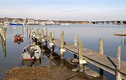
, the town has a total area of 64.4 square miles (166.8 km²), of which, 50.1 square miles (129.8 km²) of the area is land and 14.3 square miles (37 km²) of it (22.27%) is water. The majority of that water area is from the Watuppa Ponds along the Fall River line, as well as Westport Harbor, where the two branches of the Westport River
meet before emptying into Buzzards Bay
. Westport is bordered by Fall River to the northwest and west, Dartmouth to the east, Buzzards Bay to the south, and Little Compton
and Tiverton, Rhode Island
to the west. There are several unofficial localities within town; the most prominent of these are Acoaxet, Head of Westport, South Westport, Westport Point, and Westport Factory. It is the southwestern town of Bristol County. Acoaxet is unique among them, in that because of the west branch of the Westport River, it is inaccessible by land except by passing through neighboring Little Compton. Westport is approximately thirty miles southeast of Providence
, Rhode Island
, and approximately sixty miles south of Boston.
Spring: Season effects begin in the end of March and end in mid May with mostly rain in March and April and sun/ rain in May. Day temperatures: High's in the high 50's/ 60's. Night temperatures: Low's in the high 40's/ 50's.
Summer: Season effects begin in the end of May and end in mid September with mostly sunny conditions. Most rain comes at night, but you can see a few rain days. Hurricanes/ tropical storms usually hit or come close to Westport during late August and September. Day temperatures: High's in the 80's. Nigh temperatures: Low's in the 60's and 70's. The hottest time of the year in Westport occurs in the summer which is in mid July which we usually see one random day of high temperatures at or near 100 degrees (F) and get a one week stretch of temperatures in the low 90's.
Fall/ Autumn: Season effects begin in the end of September and end in the end of November with mostly sunny crisp, cool days. Day temperatures: High's in the 50's. Night temperatures: Low's in the high 30's and 40's.
Hurricanes: Tropical systems usually hit Westport or come close to Westport in the end of August and the entire month of September. The last tropical system to hit Westport was Tropical Storm Irene on Sunday, August 28, 2011 which hit here at about 70 mph and brought mostly wind which knocked down many tree's and tree branches. The storm also did huge damage to Westport's East Beach and East Beach Road as the powerful waves ripped apart the entire street. Tropical Storm Irene which previously got up to a category 3 hurricane, then downgrated to a category 2 when hitting the Carolina's and Virginia, and hit New Jersey as a category 1 before downgrading by only 5 mph to a tropical storm hitting Westport.
Other natural disasters: Usually hurricanes are the only natural disasters to effect Westport. A tornado was never spotted in Westport, but in the early parts of summer, some tornadoes can touch down in western parts of Massachusetts near Springfield, MA and Worcester, MA. A major earthquake has never really been felt in Westport, but about every five years a very weak earthquake may be felt or sometimes not felt at all. Tsunami's are also very much possible here in Westport especially since Westport a coastal town, but a tsunami has never been recorded here.
Westport Middle School also has school sports teams such as boys and girls soccer, field hockey, boys basketball, girls basketball, baseball and softball. These teams travel around Southeastern Massachusetts, no farther than Bridgewater, MA which is a few miles south of Boston.
The town also has their own organized sports program, the Westport Youth Athletics Association (WYAA) which serves sports from as soon as even three years old, all the way up until 10th grade. The WYAA's goal is to give kids the chance to play any sport they want no matter what athletic standers they meet. The WYAA offers boys basketball, girls basketball, soccer, baseball and softball. Boys basketball is the sport that goes all the way up to 10th grade with the prep division which 9th and 10th graders, usually at Westport High School play. Go to wyaa.net to get more information.
, U.S. Route 6
, and Route 177, which has its eastern terminus at its intersection at Route 6. Route 88
, the longest state highway in Massachusetts to be entirely located within one town, serves as an access from I-195 to Horseneck Beach State Reservation via Exit 10.
There is bus service along Route 6 provided by the Southeastern Regional Transit Authority (SRTA). During the summer, service is extended to Horseneck Beach. Regional bus service can be reached in Fall River, and regional rail service can be reached in Providence. Recently plans have been in the works to bring commuter rail service to Fall River; however, the plans have not yet been finalized. The nearest airport is in New Bedford Regional Airport, 8 miles away. National airline service can be reached at T.F. Green Airport in Warwick, Rhode Island, 36 miles away.
, which is represented by Barney Frank
. The state's senior (Class II) Senator, re-elected in 2008, is John Kerry
. The other Senator is Scott Brown, elected in 2010. Westport is patrolled by the 3rd (Dartmouth) Barracks of Troop D of the Massachusetts State Police
.
Westport is governed by an open town meeting
, led by a board of selectmen
. There is a central police department located directly south of the Town Hall in Central Village. Westport has a Full Time Fire Department, along with call firefighters, the town has two fire stations located in the north and south of town. The Fire Department also staffs 2 Advanced Life Support Ambulances 24 hours a day. There are four post offices for the town's two ZIP code
s; The main post office on Route 6, a smaller branch near the Head of Westport, and the branch in Central Village serve the zipcode 02790, while 02791 (Westport Point) is served by the Central Village station and at the point itself. The town's library is located next to Westport Elementary School and Westport Middle School, directly west of the Head of Westport.
Westport High School is also home to the only daily high school newspaper in the country, The Villager. Produced by the students of the high school, the publication is ranked as one of the best high school papers in the country and is often entered in competitions with college newspapers throughout the U.S.
In addition to their schools, high school students may choose to attend Diman Regional Vocational Technical High School in Fall River or Bristol County Agricultural High School in Dighton, free of charge. They may also choose Bishop Stang High School in Dartmouth or Bishop Connolly High School in Fall River which includes a yearly fee of between $5,000 and $10,000. Juniors and Seniors may opt to take college classes at UMass Dartmouth in Dartmouth or Bristol Community College in Fall River to earn both high school and college credits. Internships and independent study are offered as well.
There is one private school in the town, Montessori School of the Angels which serves grades 1-8, located in the Westport Factory neighborhood. It was formerly known as Saint Joseph's Montessori, and was located in Fall River; the school building itself was formerly the Saint George's School, which closed due to lack of funding and declining attendance. Several students also attend private and charter schools in Fall River
and Dartmouth, including Bishop Connolly High School and Bishop Stang High School.
of 2010, there were 15,532 people, 5,386 households, and 4,082 families residing in the town. The population density
was 283.4 people per square mile (109.4/km²). There were 6,143 housing units at an average density of 122.7 per square mile (47.4/km²). The racial makeup of the town was 98.01% White, 0.17% African American, 0.14% Native American, 0.49% Asian, 0.02% Pacific Islander, 0.37% from other races
, and 0.79% from two or more races. Hispanic or Latino of any race were 0.69% of the population.
There were 5,386 households out of which 29.0% had children under the age of 18 living with them, 62.9% were married couples
living together, 9.0% had a female householder with no husband present, and 24.2% were non-families. 19.7% of all households were made up of individuals and 8.9% had someone living alone who was 65 years of age or older. The average household size was 2.62 and the average family size was 3.01.
In the town the population was spread out with 21.6% under the age of 18, 6.7% from 18 to 24, 28.0% from 25 to 44, 29.0% from 45 to 64, and 14.6% who were 65 years of age or older. The median age was 41 years. For every 100 females there were 96.0 males. For every 100 females age 18 and over, there were 95.2 males.
The median income for a household in the town was $55,436, and the median income for a family was $64,568. Males had a median income of $41,890 versus $30,921 for females. The per capita income
for the town was $25,281. About 3.7% of families and 4.9% of the population were below the poverty line, including 5.5% of those under age 18 and 7.9% of those age 65 or over.
Black Francis - Lead Singer and Rhythm Guitarist of the Pixies
Allen Levrault- Former Major League Baseball Player (Milwaukee Brewers from 2001-2003, and the Florida Marlins in 2003)
Wendi Nix - ESPN analyst who appear's on ESPN's Baseball Tonight show.
New England town
The New England town is the basic unit of local government in each of the six New England states. Without a direct counterpart in most other U.S. states, New England towns are conceptually similar to civil townships in other states, but are incorporated, possessing powers like cities in other...
in Bristol County
Bristol County, Massachusetts
-Demographics:As of the census of 2000, there were 534,678 people, 205,411 households, and 140,706 families residing in the county. The population density was 962 people per square mile . There were 216,918 housing units at an average density of 390 per square mile...
, Massachusetts
Massachusetts
The Commonwealth of Massachusetts is a state in the New England region of the northeastern United States of America. It is bordered by Rhode Island and Connecticut to the south, New York to the west, and Vermont and New Hampshire to the north; at its east lies the Atlantic Ocean. As of the 2010...
, United States
United States
The United States of America is a federal constitutional republic comprising fifty states and a federal district...
. The population was 15,532 at the 2010 census.
The village of North Westport
North Westport, Massachusetts
North Westport is a census-designated place in the town of Westport in Bristol County, Massachusetts, United States. The population was 4,533 at the 2000 census.-Geography:North Westport is located at ....
lies in the town.
History
Westport, so named because it was the westernmost port in the Massachusetts Bay ColonyMassachusetts Bay Colony
The Massachusetts Bay Colony was an English settlement on the east coast of North America in the 17th century, in New England, situated around the present-day cities of Salem and Boston. The territory administered by the colony included much of present-day central New England, including portions...
, was first settled in 1670, as a part of the town of Dartmouth
Dartmouth, Massachusetts
Dartmouth is a town in Bristol County, Massachusetts, United States established in 1664. The population was 30,665 at the 2000 census. It is the location of the University of Massachusetts Dartmouth....
by members of the Sisson family. The river, and the land around it, was called "Coaksett" in the original deed; the name now spelled "Acoaxet," lives on in the southwestern community along the western branch of the Westport River. Like many areas, Westport was affected by invading Wampanoags during King Phillip's War. Several small mills were built along the Westport River, and in 1787, the town, along with the town of New Bedford
New Bedford, Massachusetts
New Bedford is a city in Bristol County, Massachusetts, United States, located south of Boston, southeast of Providence, Rhode Island, and about east of Fall River. As of the 2010 census, the city had a total population of 95,072, making it the sixth-largest city in Massachusetts...
, seceded from Dartmouth. It turns out, that Dartmouth is one of Westport's huge rivals in high school sports.
There were several cotton mills along the river, the largest of which was at the junction of the river with Lake Noquochoke on the Dartmouth town line. The Macomber turnip traces its ancestry to turnips sowed in Westport shortly after 1876. During the Second World War
World War II
World War II, or the Second World War , was a global conflict lasting from 1939 to 1945, involving most of the world's nations—including all of the great powers—eventually forming two opposing military alliances: the Allies and the Axis...
, a coastal defense installation was raised on Gooseberry Island. The town is now mostly residential, with a large farming community. Horseneck Beach State Reservation
Horseneck Beach State Reservation
The Horseneck Beach State Reservation is a large public state beach reservation on Westport River, Westport Harbor, Horseneck Channel, The Let, Rhode Island Sound, and Buzzards Bay, in the southern portion of the town of Westport, Massachusetts, USA....
, located to the north and west of Gooseberry Island, is a popular summer destination for many in the area.
Geography
United States Census Bureau
The United States Census Bureau is the government agency that is responsible for the United States Census. It also gathers other national demographic and economic data...
, the town has a total area of 64.4 square miles (166.8 km²), of which, 50.1 square miles (129.8 km²) of the area is land and 14.3 square miles (37 km²) of it (22.27%) is water. The majority of that water area is from the Watuppa Ponds along the Fall River line, as well as Westport Harbor, where the two branches of the Westport River
Westport River
The Westport River lies between Narragansett Bay and Buzzards Bay in Westport, Massachusetts.-Description:The Westport River has two branches. The smaller West Branch is approximately long, rising from a confluence of brooks near the village of Adamsville, Rhode Island...
meet before emptying into Buzzards Bay
Buzzards Bay
Buzzards Bay is a bay along the southern edge of Massachusetts in the United States. The name may also refer to:*Buzzards Bay, Massachusetts, a village in Bourne, Massachusetts*Buzzards Bay , the name of the horse that won the 2005 Santa Anita Derby...
. Westport is bordered by Fall River to the northwest and west, Dartmouth to the east, Buzzards Bay to the south, and Little Compton
Little Compton, Rhode Island
Little Compton is a town in Newport County, Rhode Island, United States. Its population was 3,492 at the time of the 2010 census. Little Compton is located in southeastern Rhode Island, between the Sakonnet River and the Massachusetts state border...
and Tiverton, Rhode Island
Rhode Island
The state of Rhode Island and Providence Plantations, more commonly referred to as Rhode Island , is a state in the New England region of the United States. It is the smallest U.S. state by area...
to the west. There are several unofficial localities within town; the most prominent of these are Acoaxet, Head of Westport, South Westport, Westport Point, and Westport Factory. It is the southwestern town of Bristol County. Acoaxet is unique among them, in that because of the west branch of the Westport River, it is inaccessible by land except by passing through neighboring Little Compton. Westport is approximately thirty miles southeast of Providence
Providence, Rhode Island
Providence is the capital and most populous city of Rhode Island and was one of the first cities established in the United States. Located in Providence County, it is the third largest city in the New England region...
, Rhode Island
Rhode Island
The state of Rhode Island and Providence Plantations, more commonly referred to as Rhode Island , is a state in the New England region of the United States. It is the smallest U.S. state by area...
, and approximately sixty miles south of Boston.
Weather
Winter: Season effects begin in early December and end in mid March with snowy conditions. The snowiest times of the winter season here in Westport is in January and February. Day temperatures: High's in the 30's. Nigh temperatures: Low's in the 20's. The coldest time of the year in Westport occurs in the winter which is in the beginning of January which we can see about a random week stretch of temperatures in the 10's and can even hit 0 degrees (F) at night (rare).Spring: Season effects begin in the end of March and end in mid May with mostly rain in March and April and sun/ rain in May. Day temperatures: High's in the high 50's/ 60's. Night temperatures: Low's in the high 40's/ 50's.
Summer: Season effects begin in the end of May and end in mid September with mostly sunny conditions. Most rain comes at night, but you can see a few rain days. Hurricanes/ tropical storms usually hit or come close to Westport during late August and September. Day temperatures: High's in the 80's. Nigh temperatures: Low's in the 60's and 70's. The hottest time of the year in Westport occurs in the summer which is in mid July which we usually see one random day of high temperatures at or near 100 degrees (F) and get a one week stretch of temperatures in the low 90's.
Fall/ Autumn: Season effects begin in the end of September and end in the end of November with mostly sunny crisp, cool days. Day temperatures: High's in the 50's. Night temperatures: Low's in the high 30's and 40's.
Hurricanes: Tropical systems usually hit Westport or come close to Westport in the end of August and the entire month of September. The last tropical system to hit Westport was Tropical Storm Irene on Sunday, August 28, 2011 which hit here at about 70 mph and brought mostly wind which knocked down many tree's and tree branches. The storm also did huge damage to Westport's East Beach and East Beach Road as the powerful waves ripped apart the entire street. Tropical Storm Irene which previously got up to a category 3 hurricane, then downgrated to a category 2 when hitting the Carolina's and Virginia, and hit New Jersey as a category 1 before downgrading by only 5 mph to a tropical storm hitting Westport.
Other natural disasters: Usually hurricanes are the only natural disasters to effect Westport. A tornado was never spotted in Westport, but in the early parts of summer, some tornadoes can touch down in western parts of Massachusetts near Springfield, MA and Worcester, MA. A major earthquake has never really been felt in Westport, but about every five years a very weak earthquake may be felt or sometimes not felt at all. Tsunami's are also very much possible here in Westport especially since Westport a coastal town, but a tsunami has never been recorded here.
Sports
Westport, Massachusetts is a huge basketball and baseball town. Westport has multiple sports offered at Westport High School, which their sports team name is called the Westport Wildcats. Westport High School's sports teams there have won many awards and trophies in the past fifty years (about). Westport High School has boys basketball, girls basketball, field hockey, boys soccer, boys golf, girls volleyball, baseball, softball, and tennis (boys and girls). While Westport does not have their own football team, students from WHS can go to Bishop Connolly High School in Fall River to play football, girls soccer, boys lacrosse, and track (boys and girls). All teams usually have a successful season every year, and play to win. These teams travel locally for the most part around Southeastern Massachusetts, Rhode Island, and also a few cities up near Boston.Westport Middle School also has school sports teams such as boys and girls soccer, field hockey, boys basketball, girls basketball, baseball and softball. These teams travel around Southeastern Massachusetts, no farther than Bridgewater, MA which is a few miles south of Boston.
The town also has their own organized sports program, the Westport Youth Athletics Association (WYAA) which serves sports from as soon as even three years old, all the way up until 10th grade. The WYAA's goal is to give kids the chance to play any sport they want no matter what athletic standers they meet. The WYAA offers boys basketball, girls basketball, soccer, baseball and softball. Boys basketball is the sport that goes all the way up to 10th grade with the prep division which 9th and 10th graders, usually at Westport High School play. Go to wyaa.net to get more information.
Transportation
The town is accessible via Interstate 195Interstate 195 (Rhode Island-Massachusetts)
Interstate 195 is an Interstate Highway running a combined 40.1 miles in the U.S. states of Massachusetts and Rhode Island. It travels from a junction with Interstate 95 in Providence, Rhode Island east to a junction with Interstate 495 and Route 25 in Wareham, Massachusetts...
, U.S. Route 6
U.S. Route 6
U.S. Route 6 , also called the Grand Army of the Republic Highway, a name that honors an American Civil War veterans association, is a main route of the U.S. Highway system, running east-northeast from Bishop, California to Provincetown, Massachusetts. Until 1964, it continued south from Bishop to...
, and Route 177, which has its eastern terminus at its intersection at Route 6. Route 88
Route 88 (Massachusetts)
Route 88, is a north–south state highway in the town of Westport insoutheastern Massachusetts. At just over 11 miles, it is the longest Massachusetts state route to be situated in only one town.-Route description:...
, the longest state highway in Massachusetts to be entirely located within one town, serves as an access from I-195 to Horseneck Beach State Reservation via Exit 10.
There is bus service along Route 6 provided by the Southeastern Regional Transit Authority (SRTA). During the summer, service is extended to Horseneck Beach. Regional bus service can be reached in Fall River, and regional rail service can be reached in Providence. Recently plans have been in the works to bring commuter rail service to Fall River; however, the plans have not yet been finalized. The nearest airport is in New Bedford Regional Airport, 8 miles away. National airline service can be reached at T.F. Green Airport in Warwick, Rhode Island, 36 miles away.
Government
On the state level, Westport is located in the Eighth Bristol state representative district, which includes parts of Fall River. The town is represented by Senator Joan M. Menard (D-Fall River), Assistant Majority Leader in the state senate in the First Bristol and Plymouth district, which also includes Fall River, Freetown, Rochester, Somerset and Swansea. On the national level, the town is part of Massachusetts's 4th congressional districtMassachusetts's 4th congressional district
Massachusetts's 4th congressional district is mostly in southern Massachusetts and includes the South Coast region. It is represented by Barney Frank, who has served the district since January 1981....
, which is represented by Barney Frank
Barney Frank
Barney Frank is the U.S. Representative for . A member of the Democratic Party, he is the former chairman of the House Financial Services Committee and is considered the most prominent gay politician in the United States.Born and raised in New Jersey, Frank graduated from Harvard College and...
. The state's senior (Class II) Senator, re-elected in 2008, is John Kerry
John Kerry
John Forbes Kerry is the senior United States Senator from Massachusetts, the 10th most senior U.S. Senator and chairman of the Senate Foreign Relations Committee. He was the presidential nominee of the Democratic Party in the 2004 presidential election, but lost to former President George W...
. The other Senator is Scott Brown, elected in 2010. Westport is patrolled by the 3rd (Dartmouth) Barracks of Troop D of the Massachusetts State Police
Massachusetts State Police
The Massachusetts State Police is an agency of the Commonwealth of Massachusetts' Executive Office of Public Safety and Security responsible for criminal law enforcement and traffic vehicle regulation across the state...
.
Westport is governed by an open town meeting
Open town meeting
An open town meeting is a form of town meeting in which all registered voters of a town may vote . This form of government is typical of smaller municipalities in the New England region of the United States....
, led by a board of selectmen
Board of selectmen
The board of selectmen is commonly the executive arm of the government of New England towns in the United States. The board typically consists of three or five members, with or without staggered terms.-History:...
. There is a central police department located directly south of the Town Hall in Central Village. Westport has a Full Time Fire Department, along with call firefighters, the town has two fire stations located in the north and south of town. The Fire Department also staffs 2 Advanced Life Support Ambulances 24 hours a day. There are four post offices for the town's two ZIP code
ZIP Code
ZIP codes are a system of postal codes used by the United States Postal Service since 1963. The term ZIP, an acronym for Zone Improvement Plan, is properly written in capital letters and was chosen to suggest that the mail travels more efficiently, and therefore more quickly, when senders use the...
s; The main post office on Route 6, a smaller branch near the Head of Westport, and the branch in Central Village serve the zipcode 02790, while 02791 (Westport Point) is served by the Central Village station and at the point itself. The town's library is located next to Westport Elementary School and Westport Middle School, directly west of the Head of Westport.
Education
Westport has its own school system. There are four schools: Alice A. Macomber School, in the north of town, provides pre-school (pre-kindergarten) and kindergarten classes; Westport Elementary, near the Head of Westport, serves grades 1-4; Westport Middle, next to Westport Elementary, serves grades 5-8; and Westport High School, which serves grades 9-12. Westport High is unique in that it sometimes refers to it's arts and music departments as a separate "academy". Students who graduate from Westport with enough credits in certain fields of study will earn special academy certificates, in addition to their high school diplomas. This was modelled after University-style degrees. Their team name is the Westport Wildcats who have won multiple championships in the Mayflower League. The Wildcats are one of the very few teams in the Mayflower League who have won multiple championships in every sport. Their mascot is the Wildcat, and their colors are brown and white (a legacy of when Westport was in a different league that used Ivy League colors - Westport using Brown University's brown and white). The school is a member of the Mayflower League, and competes against smaller schools in the region.Westport High School is also home to the only daily high school newspaper in the country, The Villager. Produced by the students of the high school, the publication is ranked as one of the best high school papers in the country and is often entered in competitions with college newspapers throughout the U.S.
In addition to their schools, high school students may choose to attend Diman Regional Vocational Technical High School in Fall River or Bristol County Agricultural High School in Dighton, free of charge. They may also choose Bishop Stang High School in Dartmouth or Bishop Connolly High School in Fall River which includes a yearly fee of between $5,000 and $10,000. Juniors and Seniors may opt to take college classes at UMass Dartmouth in Dartmouth or Bristol Community College in Fall River to earn both high school and college credits. Internships and independent study are offered as well.
There is one private school in the town, Montessori School of the Angels which serves grades 1-8, located in the Westport Factory neighborhood. It was formerly known as Saint Joseph's Montessori, and was located in Fall River; the school building itself was formerly the Saint George's School, which closed due to lack of funding and declining attendance. Several students also attend private and charter schools in Fall River
Fall River
-Cities and towns:In Canada:*Fall River, Nova ScotiaIn the United States:*Fall River, Kansas*Fall River, Massachusetts, the largest city with this name*Fall River, Tennessee*Fall River, Wisconsin*Fall River County, South Dakota-Rivers:In Canada:...
and Dartmouth, including Bishop Connolly High School and Bishop Stang High School.
Demographics
As of the censusCensus
A census is the procedure of systematically acquiring and recording information about the members of a given population. It is a regularly occurring and official count of a particular population. The term is used mostly in connection with national population and housing censuses; other common...
of 2010, there were 15,532 people, 5,386 households, and 4,082 families residing in the town. The population density
Population density
Population density is a measurement of population per unit area or unit volume. It is frequently applied to living organisms, and particularly to humans...
was 283.4 people per square mile (109.4/km²). There were 6,143 housing units at an average density of 122.7 per square mile (47.4/km²). The racial makeup of the town was 98.01% White, 0.17% African American, 0.14% Native American, 0.49% Asian, 0.02% Pacific Islander, 0.37% from other races
Race (United States Census)
Race and ethnicity in the United States Census, as defined by the Federal Office of Management and Budget and the United States Census Bureau, are self-identification data items in which residents choose the race or races with which they most closely identify, and indicate whether or not they are...
, and 0.79% from two or more races. Hispanic or Latino of any race were 0.69% of the population.
There were 5,386 households out of which 29.0% had children under the age of 18 living with them, 62.9% were married couples
Marriage
Marriage is a social union or legal contract between people that creates kinship. It is an institution in which interpersonal relationships, usually intimate and sexual, are acknowledged in a variety of ways, depending on the culture or subculture in which it is found...
living together, 9.0% had a female householder with no husband present, and 24.2% were non-families. 19.7% of all households were made up of individuals and 8.9% had someone living alone who was 65 years of age or older. The average household size was 2.62 and the average family size was 3.01.
In the town the population was spread out with 21.6% under the age of 18, 6.7% from 18 to 24, 28.0% from 25 to 44, 29.0% from 45 to 64, and 14.6% who were 65 years of age or older. The median age was 41 years. For every 100 females there were 96.0 males. For every 100 females age 18 and over, there were 95.2 males.
The median income for a household in the town was $55,436, and the median income for a family was $64,568. Males had a median income of $41,890 versus $30,921 for females. The per capita income
Per capita income
Per capita income or income per person is a measure of mean income within an economic aggregate, such as a country or city. It is calculated by taking a measure of all sources of income in the aggregate and dividing it by the total population...
for the town was $25,281. About 3.7% of families and 4.9% of the population were below the poverty line, including 5.5% of those under age 18 and 7.9% of those age 65 or over.
Notable residents
Michael Houghton- Former CEO of Polaroid CorporationPolaroid Corporation
Polaroid Corporation is an American-based international consumer electronics and eyewear company, originally founded in 1937 by Edwin H. Land. It is most famous for its instant film cameras, which reached the market in 1948, and continued to be the company's flagship product line until the February...
Black Francis - Lead Singer and Rhythm Guitarist of the Pixies
Allen Levrault- Former Major League Baseball Player (Milwaukee Brewers from 2001-2003, and the Florida Marlins in 2003)
Wendi Nix - ESPN analyst who appear's on ESPN's Baseball Tonight show.