
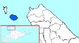
Rishiri Island
Encyclopedia
Sea of Japan
The Sea of Japan is a marginal sea of the western Pacific Ocean, between the Asian mainland, the Japanese archipelago and Sakhalin. It is bordered by Japan, North Korea, Russia and South Korea. Like the Mediterranean Sea, it has almost no tides due to its nearly complete enclosure from the Pacific...
off the coast of Hokkaidō
Hokkaido
, formerly known as Ezo, Yezo, Yeso, or Yesso, is Japan's second largest island; it is also the largest and northernmost of Japan's 47 prefectural-level subdivisions. The Tsugaru Strait separates Hokkaido from Honshu, although the two islands are connected by the underwater railway Seikan Tunnel...
, Japan
Japan
Japan is an island nation in East Asia. Located in the Pacific Ocean, it lies to the east of the Sea of Japan, China, North Korea, South Korea and Russia, stretching from the Sea of Okhotsk in the north to the East China Sea and Taiwan in the south...
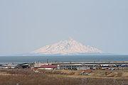
. The island is formed by the cone-shaped extinct volcanic peak of Mount Rishiri
Mount Rishiri
Mount Rishiri is a quaternary stratovolcano located off the coast of Hokkaidō, Japan in the Sea of Japan. The extinct volcano rises out of the sea forming Rishiri Island. Because its cone shape resembles Mount Fuji it is sometimes referred to as Rishiri Fuji...
. Along with Rebun
Rebun Island
Rebun Island lies in the Sea of Japan off the northwestern tip of Hokkaidō, Japan. Rebun stretches 29 kilometers in the north-south direction and 8 kilometers east-west, covering about 80 square kilometers. The island is known for its alpine flowers and the 8-Hour Hiking Course which runs from one...
and the coastal area of Sarobetsu
Sarobetsu plain
, derived from the Ainu sar and pet , is a coastal plain and low-lying moor in northwestern Hokkaidō, Japan. With an area of approximately 20,000 ha, it forms part of the Rishiri-Rebun-Sarobetsu National Park, and its wetlands are a Ramsar Site....
, Rishiri forms the Rishiri-Rebun-Sarobetsu National Park
Rishiri-Rebun-Sarobetsu National Park
is a national park on the Rishiri Island, Rebun Island, coasts of Wakkanai and Wakkasakanai and Sarobetsu Plain and the north-western edge of Hokkaidō, Japan.-External links:* http://www.biodic.go.jp/english/jpark/np/risiri_e.html...
. The main industries of Rishiri are tourism and fishing. The island is about 63 km in circumference and covers 183 km².
Other features of Rishiri Island include:
- Cape Peshi on the East side of the port Oshidomari
- Cape Senhoshi
- Neguma (Sleeping Bear) Rock
- Jimmen Rock
- Ponmoshiri Island
- Hime Marsh
- Menūshoro Marsh
- Otatomari Marsh
Communities
The island and its communities belong to the Rishiri DistrictRishiri District, Hokkaido
is a district located in Sōya Subprefecture, Hokkaidō, Japan. The district consists of Rishiri Island, in the Sea of Japan to the west of the northern tip of Hokkaidō....
and Rishirifujiin Sōya Subprefecture
Soya Subprefecture
is a subprefecture of Hokkaidō, Japan. Its population is estimated to be 77,500 as of July 31, 2004 and its area is 4,050.84 km². It is the northernmost subprefecture of Japan.Wakkanai Airport is located in Wakkanai...
. The districts consist of the towns of the same name:
- Rishiri TownRishiri, Hokkaidois a town located on Rishiri Island in Rishiri District, Sōya, Hokkaidō, Japan.As of 2008, the town has an estimated population of 2,684 and a density of 35.1 persons per km². The total area is 76.49 km².Rishiri Airport is located in nearby Rishirifuji....
- Rishirifuji TownRishirifuji, Hokkaidois a town located on Rishiri Island in Rishiri District, Sōya, Hokkaidō, Japan.As of 2008, the town has an estimated population of 2,954 and a density of 28.5 persons per km². The total area is 105.69 km².-Geography:...
These towns include the following communities, listed from the North side of the island, clockwise around:
- Oshidomari
- Himenuma
- Oniwaki
- Numaura
- Misaki, Rishiri
- Senposhi
- Kusure
- Randomari
- Kutsugata
- Shinminato, Rishiri
- Motodomari
Transportation
- Ferry service to RebunRebun IslandRebun Island lies in the Sea of Japan off the northwestern tip of Hokkaidō, Japan. Rebun stretches 29 kilometers in the north-south direction and 8 kilometers east-west, covering about 80 square kilometers. The island is known for its alpine flowers and the 8-Hour Hiking Course which runs from one...
, Wakkanai, and Otaru - Air link to Wakkanai
A bus runs the circuit route around the island.
Rishiri Airport is located in Rishirifuji
Rishirifuji, Hokkaido
is a town located on Rishiri Island in Rishiri District, Sōya, Hokkaidō, Japan.As of 2008, the town has an estimated population of 2,954 and a density of 28.5 persons per km². The total area is 105.69 km².-Geography:...
.