
History of Saskatoon
Encyclopedia
Saskatoon
Saskatoon is a city in central Saskatchewan, Canada, on the South Saskatchewan River. Residents of the city of Saskatoon are called Saskatonians. The city is surrounded by the Rural Municipality of Corman Park No. 344....
, Saskatchewan
Saskatchewan
Saskatchewan is a prairie province in Canada, which has an area of . Saskatchewan is bordered on the west by Alberta, on the north by the Northwest Territories, on the east by Manitoba, and on the south by the U.S. states of Montana and North Dakota....
, Canada
Canada
Canada is a North American country consisting of ten provinces and three territories. Located in the northern part of the continent, it extends from the Atlantic Ocean in the east to the Pacific Ocean in the west, and northward into the Arctic Ocean...
, in 1883 when Toronto
Toronto
Toronto is the provincial capital of Ontario and the largest city in Canada. It is located in Southern Ontario on the northwestern shore of Lake Ontario. A relatively modern city, Toronto's history dates back to the late-18th century, when its land was first purchased by the British monarchy from...
Methodists, wanting to escape the liquor trade in that city, decided to set up a "dry" community in the rapidly-growing prairie
Canadian Prairies
The Canadian Prairies is a region of Canada, specifically in western Canada, which may correspond to several different definitions, natural or political. Notably, the Prairie provinces or simply the Prairies comprise the provinces of Alberta, Saskatchewan, and Manitoba, as they are largely covered...
region. As of 1882 this area was a part of the provisional district
Districts of Northwest Territories
The vastness of Canada's Northwest Territories meant that for much of its history it was divided into several districts for ease of administration. The number and size of these territorial districts varied as other provinces and territories of Canada were created and expanded...
named Saskatchewan
District of Saskatchewan
The District of Saskatchewan was a regional administrative district of Canada's Northwest Territories. Much of the area was incorporated into the province of Saskatchewan. The western part became part of Alberta, and the eastern part is now part of Manitoba. Its capital was Prince Albert...
, North-West Territories
Territorial evolution of Canada
The federation of Canada was created in 1867 when three colonies of British North America were united. One of these colonies split into two new provinces, three other colonies joined later...
. Their organization, the Temperance Colonization Society, first examined this area in 1882 and found that it would make an excellent location to found their community based on the ideals of the temperance movement
Temperance movement
A temperance movement is a social movement urging reduced use of alcoholic beverages. Temperance movements may criticize excessive alcohol use, promote complete abstinence , or pressure the government to enact anti-alcohol legislation or complete prohibition of alcohol.-Temperance movement by...
. The settlers, led by John Neilson Lake
John Neilson Lake
John Neilson Lake was originally a preacher for the Methodist Church in Canada and eventually selected the site that became the city of Saskatoon, Saskatchewan, Canada...
, arrived on the site of what is now Saskatoon by traveling by railway from Ontario
Ontario
Ontario is a province of Canada, located in east-central Canada. It is Canada's most populous province and second largest in total area. It is home to the nation's most populous city, Toronto, and the nation's capital, Ottawa....
to Moose Jaw, Saskatchewan
Moose Jaw, Saskatchewan
Moose Jaw is a city in south-central Saskatchewan, Canada on the Moose Jaw River. It is situated on the Trans-Canada Highway, west of Regina. Residents of Moose Jaw are known as Moose Javians. It is best known as a retirement and tourist city that serves as a hub to the hundreds of small towns...
, and then completing the final leg via horse-drawn cart (the railway had yet to be completed to Saskatoon). The plan for the Temperance Colony soon failed as the group was unable to obtain a large block of land within the community. Nonetheless, John Lake is commonly identified as the founder of Saskatoon; a public school, a park and two streets are named after him (Lake Crescent, which was developed in the 1960s, and Eastlake Avenue, originally Lake Avenue (as testified on the first map of Saskatoon from 1883), but later changed for reasons unknown).
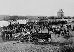
North-West Rebellion
The North-West Rebellion of 1885 was a brief and unsuccessful uprising by the Métis people of the District of Saskatchewan under Louis Riel against the Dominion of Canada...
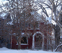
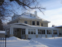
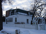
. One house, the Marr Residence
Marr Residence
The Marr Residence is a historic site located in the Nutana neighborhood of Saskatoon, Saskatchewan, Canada and was part of the original temperance colony that predated the city. Built in 1884 by stonemason Alexander "Sandy" Marr, it is the oldest building in Saskatoon on its original site...
, is currently a heritage site run by the Meewasin Valley Authority
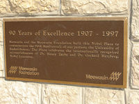
Meewasin Valley Authority
The Meewasin Valley Authority is a conservation organization created by the Provincial Government of Saskatchewan in Canada and is dedicated to conserving the cultural and natural resources of the South Saskatchewan River Valley. The authorities activities include education, development and...
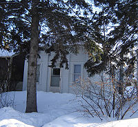
. The first school, Victoria School, opened for classes at the corner of 11th Street and Broadway Avenue in 1888. This small school, now called the "Little Stone Schoolhouse
Victoria School (Saskatoon)
The original Victoria School is a designated historic building in Saskatoon, Saskatchewan, Canada. The stone school house built in 1888 by stonemason Alexander Marr as the first school house of the temperance colony...
", now sits on the campus of the University of Saskatchewan
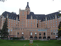
University of Saskatchewan
The University of Saskatchewan is a Canadian public research university, founded in 1907, and located on the east side of the South Saskatchewan River in Saskatoon, Saskatchewan, Canada. An "Act to establish and incorporate a University for the Province of Saskatchewan" was passed by the...
.
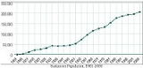
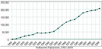
| Rate of Population Change | |||
|---|---|---|---|
| 1901–2006 | |||
| Census Year | Population | Population Change |
5-year Change |
| 1901 | 311 | ||
| 1906 | 3,011 | 2,700 | 868% |
| 1911 | 12,004 | 8,993 | 299% |
| 1916 | 21,054 | 9,050 | 75% |
| 1921 | 25,739 | 4,685 | 22% |
| 1926 | 31,234 | 5,495 | 21% |
| 1931 | 43,291 | 12,057 | 39% |
| 1936 | 41,734 | (1,557) | -4% |
| 1941 | 43,027 | 1,293 | 3% |
| 1946 | 46,028 | 3,001 | 7% |
| 1951 | 53,268 | 7,240 | 16% |
| 1956 | 72,858 | 19,590 | 37% |
| 1961 | 95,526 | 22,668 | 31% |
| 1966 | 115,247 | 19,721 | 21% |
| 1971 | 126,450 | 11,203 | 10% |
| 1976 | 133,750 | 7,300 | 6% |
| 1981 | 154,210 | 20,460 | 15% |
| 1986 | 177,641 | 23,431 | 15% |
| 1991 | 186,058 | 8,417 | 4.74% |
| 1996 | 193,647 | 7,589 | 4% |
| 2001 | 196,811 | 3,164 | 2% |
| 2006* | 206,500 | 9,689 | 5% |
| *The 2006 population number and five-year population change numbers are estimates based on Census data. |
|||
Hub city and agricultural boom
The Qu'Appelle, Long Lake and Saskatchewan RailwayQu'Appelle, Long Lake and Saskatchewan Railroad and Steamboat Company
The Qu'Appelle, Long Lake and Saskatchewan Railroad and Steamboat Company was a railway that operated between Regina, Saskatchewan and Prince Albert, Saskatchewan, Canada via Craik, Saskatoon and Rosthern....
reached Saskatoon in 1890 and crossed the South Saskatchewan River where the Senator Sid Buckwold Bridge now stands, causing a boom in development on the west side of the river. In 1901, Saskatoon's population hit 113. A third settlement, Riversdale
Riversdale, Saskatoon
Riversdale is an older inner city neighbourhood located near the center of Saskatoon, Saskatchewan, Canada. It includes the business district of 20th Street. It consists mostly of low-density, single detached dwellings. As of 2006, the area is home to 2,335 residents...
, also began just southwest of Saskatoon.
1903 saw an economic boom for Saskatoon with the encampment of Barr colonists
History of Saskatchewan
History of Saskatchewan encompasses the study of past human events and activities of the province of Saskatchewan, the middle of Canada's three prairie provinces. Archaeological studies give some clues as to the history and lifestyles of the Palaeo-Indian, Taltheilei, and Shield Archaic Traditions...
on their way to the Brittania colony. A town charter for the west side of the river was obtained in 1903; Nutana became a village in the same year.
Ice dam
An ice dam occurs when water builds up behind a blockage of ice. Ice dams can occur in various ways.-Caused by a glacier:Sometimes a glacier flows down a valley to a confluence where the other branch carries an unfrozen river...
on the South Saskatchewan River
South Saskatchewan River
The South Saskatchewan River is a major river in Canada that flows through the provinces of Alberta and Saskatchewan....
. The Grand Trunk Pacific Railway system survey proposed Hanley as its northern terminal between Regina and Prince Albert. Saskatoon's Board of Trade sent delegates from Saskatoon to Ottawa
Ottawa
Ottawa is the capital of Canada, the second largest city in the Province of Ontario, and the fourth largest city in the country. The city is located on the south bank of the Ottawa River in the eastern portion of Southern Ontario...
to discuss the river crossing and proposed city bridges. Their mission resulted in the selection of Saskatoon as the divisional centre for both the Canadian Pacific Railway
Canadian Pacific Railway
The Canadian Pacific Railway , formerly also known as CP Rail between 1968 and 1996, is a historic Canadian Class I railway founded in 1881 and now operated by Canadian Pacific Railway Limited, which began operations as legal owner in a corporate restructuring in 2001...
and the Grand Trunk Pacific Railway
Grand Trunk Pacific Railway
The Grand Trunk Pacific Railway was a historical Canadian railway.A wholly owned subsidiary of the Grand Trunk Railway , the GTPR was constructed by GTR using loans provided by the Government of Canada. The company was formed in 1903 with a mandate to build west from Winnipeg, Manitoba to the...
; both of these built bridges near the town by 1907. The QLL&SR bridge was rebuilt in 1905, and again after a train fell through it in March 1914; it was demolished in 1965 to make way for the Senator Sid Buckwold Bridge and the Idylwyld Freeway.
In 1906 Saskatoon became a city with a population of 4,500, which included the communities of Saskatoon, Riversdale
Riversdale, Saskatoon
Riversdale is an older inner city neighbourhood located near the center of Saskatoon, Saskatchewan, Canada. It includes the business district of 20th Street. It consists mostly of low-density, single detached dwellings. As of 2006, the area is home to 2,335 residents...
, and Nutana
Nutana, Saskatoon
Nutana is a primarily residential neighbourhood located near the center of Saskatoon, Saskatchewan, Canada. It includes the business district of Broadway Avenue. It comprises a nearly even mixture of low-density, single detached dwellings and apartment-style multiple unit dwellings. As of 2009,...
.
Following the formation of the Province of Saskatchewan
Saskatchewan
Saskatchewan is a prairie province in Canada, which has an area of . Saskatchewan is bordered on the west by Alberta, on the north by the Northwest Territories, on the east by Manitoba, and on the south by the U.S. states of Montana and North Dakota....
September 1, 1905, premier Hon. Walter Scott
Thomas Walter Scott
Thomas Walter Scott – known less formally as Walter Scott – was the first Premier of the province of Saskatchewan in Canada .-Background:...
focused on the creation of a provincial university and agricultural college. Moose Jaw
Moose Jaw, Saskatchewan
Moose Jaw is a city in south-central Saskatchewan, Canada on the Moose Jaw River. It is situated on the Trans-Canada Highway, west of Regina. Residents of Moose Jaw are known as Moose Javians. It is best known as a retirement and tourist city that serves as a hub to the hundreds of small towns...
, Prince Albert
Prince Albert, Saskatchewan
Prince Albert is the third-largest city in Saskatchewan, Canada. It is situated in the centre of the province on the banks of the North Saskatchewan River. The city is known as the "Gateway to the North" because it is the last major centre along the route to the resources of northern Saskatchewan...
, Saskatoon, Regina
Regina, Saskatchewan
Regina is the capital city of the Canadian province of Saskatchewan. The city is the second-largest in the province and a cultural and commercial centre for southern Saskatchewan. It is governed by Regina City Council. Regina is the cathedral city of the Roman Catholic and Romanian Orthodox...
, Qu'Appelle
Qu'Appelle, Saskatchewan
Qu'Appelle, Saskatchewan, is a small village and formerly in ecclesiastical terms a city, with considerable historic significance located on Trans-Canada Highway and the Canadian Pacific Railway mainline, some east of the provincial capital of Regina.Qu'Appelle was for a time the terminus of the...
, Indian Head
Indian Head, Saskatchewan
Indian Head is a town in southeast Saskatchewan, Canada, east of Regina. The town is directly north of the Trans-Canada Highway. The town is known for its federally-operated Prairie Farm Rehabilitation Administration experimental farm and tree nursery that produces seedlings for shelter...
and Battleford were all under consideration for this location. President Walter Murray
Walter Charles Murray
Walter Charles Murray was the first President of the University of Saskatchewan.-Biography:Born in Kings County, New Brunswick, he received a Bachelor of Arts degree from the University of New Brunswick in 1886. In 1891, he received a Master of Arts degree from the University of Edinburgh...
and the Board of University Governors voted in favour of Saskatoon on April 7, 1907.
Grand Trunk Bridge (Saskatoon)
The Grand Trunk Bridge is a Canadian steel trestle railway bridge that spans the South Saskatchewan River in Saskatoon, Saskatchewan. It was built in 1908 as part of the Grand Trunk Pacific Railway project...
. The geographical barrier: South Saskatchewan River
South Saskatchewan River
The South Saskatchewan River is a major river in Canada that flows through the provinces of Alberta and Saskatchewan....
between Nutana and West Saskatoon was overcome with the building of the Traffic Bridge, which opened in 1907. The physical barrier of the CNR rail yards isolated Riversdale and Saskatoon. Road underpasses below the rail line were built at 19th and 23rd Streets, and a wooden pedestrian overpass at 20th Street.
From the end of the Louis Riel Rebellion
North-West Rebellion
The North-West Rebellion of 1885 was a brief and unsuccessful uprising by the Métis people of the District of Saskatchewan under Louis Riel against the Dominion of Canada...
to 1913, Saskatoon was celebrating boom years. The main contributing factors of the exponential growth were:
- Temperance colony settlement of the late 19th century.
- Economic surge created by the Barr colonists 1903.
- Saskatoon becoming western Canada's railway network hub.
- Acquisition of the University of SaskatchewanUniversity of SaskatchewanThe University of Saskatchewan is a Canadian public research university, founded in 1907, and located on the east side of the South Saskatchewan River in Saskatoon, Saskatchewan, Canada. An "Act to establish and incorporate a University for the Province of Saskatchewan" was passed by the...
.
Post-War years
After World War IWorld War I
World War I , which was predominantly called the World War or the Great War from its occurrence until 1939, and the First World War or World War I thereafter, was a major war centred in Europe that began on 28 July 1914 and lasted until 11 November 1918...
, the Dirty Thirties
Dust Bowl
The Dust Bowl, or the Dirty Thirties, was a period of severe dust storms causing major ecological and agricultural damage to American and Canadian prairie lands from 1930 to 1936...
and Depression
Great Depression in Canada
Canada was hit hard by the Great Depression. Between 1929 and 1939, the gross national product dropped 40% . Unemployment reached 27% at the depth of the Depression in 1933...
years saw migration away from bankrupt farms and towards a hope of employment in the cities. The socio-economic changes brought about by World War II
World War II
World War II, or the Second World War , was a global conflict lasting from 1939 to 1945, involving most of the world's nations—including all of the great powers—eventually forming two opposing military alliances: the Allies and the Axis...
and the industrial revolution saw a shift from rural life to urban living. Saskatoon was not only a centre for the British Commonwealth Air Training Plan
British Commonwealth Air Training Plan
The British Commonwealth Air Training Plan , known in some countries as the Empire Air Training Scheme , was a massive, joint military aircrew training program created by the United Kingdom, Canada, Australia and New Zealand, during the Second World War...
during the 1940s, but also became a major regional distribution and service centre. Saskatoon experienced a severe shortage of residential dwellings between 1945 and 1960.
During the 1960s, the CNR rail yards were relocated to Chappell Drive, making room for the Idylwyld Freeway and Midtown Plaza
Midtown Plaza (Saskatoon)
Midtown Plaza is a shopping mall in Downtown Saskatoon, Saskatchewan, Canada, that is owned by the Oxford Properties Group. The two main anchors are Sears Canada and The Bay and the shopping centre has a total store count of approximately 130 stores, making it the largest shopping centre in...
in the first Saskatoon Downtown
Central Business District, Saskatoon
The Central Business District is one of seven suburban development districts in Saskatoon, Saskatchewan, Canada. The central business district is Ward 6 of a Mayor-Council government represented by councillor Charlie Clark. Formerly called West Saskatoon, this area arose when the steam engines...
revitalisation project.
In 1906, the boundaries of Saskatoon were Clarence Avenue to the east, Taylor Street to the south, Avenue P to the west, and 33rd Street East to the north. This area is roughly the same as the core neighborhood suburban development area
Core Neighbourhoods SDA, Saskatoon
Core Neighbourhoods Suburban Development Area is an area in Saskatoon, Saskatchewan, Canada. It is a part of the west and the east side community of Saskatoon, straddling the South Saskatchewan River...
. These boundaries remained basically the same for approximately 40 years until Saskatoon reached financial stability during World War II
World War II
World War II, or the Second World War , was a global conflict lasting from 1939 to 1945, involving most of the world's nations—including all of the great powers—eventually forming two opposing military alliances: the Allies and the Axis...
.
The following suburban development areas saw neighborhoods developed between 1940 and 1980: Nutana SDA on the east side; on the west side Confederation SDA and Lawson SDA.
In 1955, Montgomery Place and in 1956 the neighboring town of Sutherland were annexed
Annexation
Annexation is the de jure incorporation of some territory into another geo-political entity . Usually, it is implied that the territory and population being annexed is the smaller, more peripheral, and weaker of the two merging entities, barring physical size...
by the quickly-growing City of Saskatoon This growth continued until the mid-1980s.
Technological, educational and cultural amenities have also expanded to meet the increased demand in this growing city.
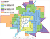
| Annexation of Saskatoon Neighbourhoods by year, 1911–2005. | |||
|---|---|---|---|
| 1911 | Adelaide Avalon Avalon, Saskatoon Avalon is a mostly residential neighbourhood located in south-central Saskatoon, Saskatchewan, Canada. It is a suburban subdivision, consisting mostly of low-density, single detached dwellings. As of 2007, the area is home to 3,214 residents... Exhibition Exhibition, Saskatoon The Exhibition subdivision of Saskatoon, Saskatchewan, Canada, is located on the banks of the South Saskatchewan River and was developed between the two major World Wars. To the west is the Diefenbaker Management Area which boasts the Diefenbaker park and Pioneer Cemetery... |
Grosvenor Park Grosvenor Park, Saskatoon Grosvenor Park is a mostly residential neighbourhood located in east-central Saskatoon, Saskatchewan, Canada. It is a suburban subdivision, composed of a near-even mix of low-density, single detached dwellings and apartment-style units. As of 2006, the area is home to 1,697 residents... Holliston Holliston, Saskatoon Holliston is a primarily residential neighbourhood located in the southeast part of Saskatoon, Saskatchewan, Canada. It includes part of the 8th Street business district. Just over half of its dwellings are single detached houses, with a sizeable minority of duplex or apartment-style multiple unit... Mayfair Mayfair, Saskatoon Mayfair is currently a neighborhood in the city of Saskatoon, Saskatchewan, Canada. Mayfair started out as a community outside of the villages of Riversdale, Nutana and Saskatoon and appears as its own place name on a map of 1907. In 1909 there were 60 residences built in Mayfair, and in 1911,... |
Mount Royal Mount Royal, Saskatoon Mount Royal is a neighbourhood on the westside of Saskatoon, Saskatchewan in the Confederation SDA. Having a population of 4.259 residents, the neighborhood consists of 3 elementary schools and 2 sister secondary schools.-Demographics:... East North Park North Park, Saskatoon North Park is a community which is just to the north of the Meewasin Riverworks observation area and the CPR Bridge. It has access along its eastern perimeter to the scenic walking trails along the South Saskatchewan River developed by the Meewasin Valley Authority. The average home selling... Nutana Park Nutana Park, Saskatoon Nutana Park is a mostly residential neighbourhood located in south-central Saskatoon, Saskatchewan, Canada. It is a suburban subdivision, consisting mostly of low-density, single detached dwellings. As of 2007, the area is home to 2,748 residents... Pleasant Hill Pleasant Hill, Saskatoon Pleasant Hill is a neighborhood of Saskatoon, Saskatchewan, Canada. The Governments are undertaking a major re-vitalization project of Pleasant Hill. $3.5 million dollars is being invested in the business, and residential areas as well as in St. Mary's School... Varsity View Varsity View, Saskatoon Varsity View is a mostly residential neighbourhood located near the center of Saskatoon, Saskatchewan, Canada. It is immediately south of the University of Saskatchewan campus. It is an older suburban subdivision, comprising a mixture of low-density, single detached dwellings, detached duplexes and... Westview Westview, Saskatoon Westview is a suburban community in the Confederation Suburban Development Area of Saskatoon, Saskatchewan. Originally named "Tuxedo Park" by real estate developers in 1912, the area remained undeveloped until the 1960s... |
| 1955-59 | Brevoort Park Brevoort Park, Saskatoon Brevoort Park is a primarily residential neighbourhood located in the southeast part of Saskatoon, Saskatchewan, Canada. It includes part of the 8th Street business district. Just over half of its dwellings are single detached houses, with a sizeable minority of duplex or apartment-style multiple... College Park College Park, Saskatoon College Park is a primarily residential neighbourhood located in the east-central part of Saskatoon, Saskatchewan, Canada. The majority of its residents live in single-family detached dwellings, with a sizable minority of high-density, multiple-unit dwellings. As of 2007, the area is home to 5,255... Eastview Eastview, Saskatoon Eastview is a mostly residential neighbourhood located in south-central Saskatoon, Saskatchewan, Canada. It is a suburban subdivision, consisting of low-density, single detached dwellings, low-rise apartment buildings and semi-detached houses. As of 2007, the area is home to 3,566 residents... Forest Grove Forest Grove, Saskatoon Forest Grove is a primarily residential neighbourhood located in northeast Saskatoon, Saskatchewan, Canada. It is mostly made up of low-density single detached dwellings, with a sizeable minority of multiple-unit apartment dwellings. As of 2006, the area is home to 5,767 residents... |
Greystone Heights Greystone Heights, Saskatoon Greystone Heights is a mostly residential neighbourhood located in east-central Saskatoon, Saskatchewan, Canada. It is a suburban subdivision, consisting mostly of low-density, single detached dwellings and a sizeable minority of apartment-style multiple-unit dwellings. As of 2007, the area is home... Hudson Bay Industrial Hudson Bay Industrial, Saskatoon Hudson Bay Industrial Saskatoon, Saskatchewan, is in the Northwest section of the North West Industrial SDA. Now named Hudson Bay Industrial, in the early days of the Saskatoon's history, the area between 56th Street and 60th Street was originally to have been Swastika Park... Meadow Green |
Montgomery Place Montgomery Place, Saskatoon Montgomery Place, is a post World War II community erected for veterans outside of the city of Saskatoon, Saskatchewan, which consists primarily of residential homes. It was amalgamated within the city of Saskatoon in 1956. Montgomery Place has an average household size of 3 persons, and... Mount Royal West Mount Royal, Saskatoon Mount Royal is a neighbourhood on the westside of Saskatoon, Saskatchewan in the Confederation SDA. Having a population of 4.259 residents, the neighborhood consists of 3 elementary schools and 2 sister secondary schools.-Demographics:... Richmond Heights Richmond Heights, Saskatoon Richmond Heights, adjacent to the South Saskatchewan River, features walking trails in the Meewasin Valley. G.D. Archibald Park North hosts baseball and soccer games. Luther Heights is a Luther care community for those aged 60 and over. The average home selling price in 2006 was $121,111, and... River Heights 1 River Heights, Saskatoon River Heights is a neighbourhood in Lawson Suburban Development Area, Saskatoon, Saskatchewan. Its eastern boundary borders the South Saskatchewan River. The suburb is just south of the Mall at Lawson Heights. Development of the neighbourhood began in the very early 1960s , with full build out... Silverspring Silverspring, Saskatoon Silverspring is a residential neighbourhood located in northeast Saskatoon, Saskatchewan, Canada. It is a typical suburban subdivision, composed mostly of low-density, single detached houses. As of 2007, the area is home to 4,936 residents... South West Industrial Sutherland U of S University of Saskatchewan The University of Saskatchewan is a Canadian public research university, founded in 1907, and located on the east side of the South Saskatchewan River in Saskatoon, Saskatchewan, Canada. An "Act to establish and incorporate a University for the Province of Saskatchewan" was passed by the... |
| 1960-64 | C.N. Industrial 1 Massey Place Massey Place, Saskatoon Massey Place, is a geographically localised subdivision of the Confederation Suburban Development Area in the city of Saskatoon, Saskatchewan which is nestled around Archibald McDonald Park. Mcdonald Park is centrally located along the northern perimeter of 33rd Street East... |
Confederation Suburban Ctr. Confederation Suburban Centre, Saskatoon Confederation Suburban Centre is a community in the city of Saskatoon, Saskatchewan, which consists primarily of commercial development.-Demographics:... Westview Westview, Saskatoon Westview is a suburban community in the Confederation Suburban Development Area of Saskatoon, Saskatchewan. Originally named "Tuxedo Park" by real estate developers in 1912, the area remained undeveloped until the 1960s... |
Fairhaven Fairhaven, Saskatoon Fairhaven is a neighbourhood in Saskatoon, Saskatchewan, Canada. It is close to both Catholic and public elementary schools. A strip mall is within the Fairhaven subdivision... |
| 1965-69 | Airport Industrial | C.N. Industrial 2 | South Nutana Park Nutana Park, Saskatoon Nutana Park is a mostly residential neighbourhood located in south-central Saskatoon, Saskatchewan, Canada. It is a suburban subdivision, consisting mostly of low-density, single detached dwellings. As of 2007, the area is home to 2,748 residents... |
| 1970-74 | Airport Confederation East College Park |
Fairhaven Fairhaven, Saskatoon Fairhaven is a neighbourhood in Saskatoon, Saskatchewan, Canada. It is close to both Catholic and public elementary schools. A strip mall is within the Fairhaven subdivision... Pacific Heights Pacific Heights, Saskatoon Pacific Heights is geographically located in north west Saskatoon. The main construction boom for this community was the 1970s, during which the City of Saskatoon annexed the land... River Heights 2 River Heights, Saskatoon River Heights is a neighbourhood in Lawson Suburban Development Area, Saskatoon, Saskatchewan. Its eastern boundary borders the South Saskatchewan River. The suburb is just south of the Mall at Lawson Heights. Development of the neighbourhood began in the very early 1960s , with full build out... |
Wildwood |
| 1975-79 | Briarwood Briarwood, Saskatoon Briarwood is a residential neighbourhood located in the southeast part of Saskatoon, Saskatchewan, Canada. The majority of its residents live in low-density, single detached dwellings. As of 2009, the area is home to 4,473 residents... Dundonald Dundonald, Saskatoon Dundonald is one of many subdivisions of the city of Saskatoon, Saskatchewan which was built in the 1980s, and until recently was the farthest northwest quarter of the city of Saskatoon. The North West Development area is some of the latest land to be annexed by the city of Saskatoon, however is... Hampton Village Hampton Village, Saskatoon -External links:****- References :*Bill Barry, Geographic Names of Saskatchewan... |
Hudson Bay Ind. Hudson Bay Industrial, Saskatoon Hudson Bay Industrial Saskatoon, Saskatchewan, is in the Northwest section of the North West Industrial SDA. Now named Hudson Bay Industrial, in the early days of the Saskatoon's history, the area between 56th Street and 60th Street was originally to have been Swastika Park... Lakeridge Lakeridge, Saskatoon Lakeridge is a residential neighbourhood located in the southeast part of Saskatoon, Saskatchewan, Canada. Almost all of its residents live in low-density, single detached houses. As of 2009, the area is home to 4,047 residents... Lakeview Lakeview, Saskatoon Lakeview is a primarily residential neighbourhood located in the southeast part of Saskatoon, Saskatchewan, Canada. The majority of its residents live in low-density, single detached dwellings, with a sizeable minority of semi-detached or apartment-style multiple unit dwellings. As of 2010, the... |
Lawson Heights Lawson Heights, Saskatoon Lawson Heights derived its origins when ReverendStephen George Lawson homesteaded here on the North east quarter of section 10 Township 37 Range 5 West of the 3rd Meridian. He had come from Prince Edward Island and was a Presbyterian minister.... Marquis Industrial Marquis Industrial, Saskatoon Marquis Industrial is an industrial park located in the North Industrial SDA Suburban Development Area of Saskatoon, Saskatchewan. Industrial parks are usually located close to transport facilities, especially where more than one transport modalities coincide. Sk Hwy 11, and Sk Hwy 12 are all... Parkridge Parkridge, Saskatoon Parkridge is a residential community in western Saskatoon, Saskatchewan, located on land annexed by the city between 1975 and 1979. Development of the subdivision Parkridge is a residential community in western Saskatoon, Saskatchewan, located on land annexed by the city between 1975 and 1979. ... Silverwood Heights Silverwood Heights, Saskatoon Silverwood Heights is a mostly residential neighbourhood located in north-central Saskatoon, Saskatchewan, Canada. It is a suburban subdivision, composed mostly of single detached dwellings and some multiple-unit apartment and semi-detached dwellings. As of 2009, the area is home to 10,786 residents... Wildwood Wildwood, Saskatoon Wildwood is a primarily residential neighbourhood located in the southeast part of Saskatoon, Saskatchewan, Canada. It includes part of the 8th Street business district. The majority of its residents live in townhouse or apartment-style multiple unit dwellings, with a sizeable minority of... Willowgrove Willowgrove, Saskatoon Willowgrove is a primarily residential neighbourhood located in northeast Saskatoon, Saskatchewan, Canada. It comprises a mix of single-family detached houses and multiple-unit dwellings. As of 2006, the area is home to 443 residents... University Heights S.C. University Heights Suburban Centre, Saskatoon University Heights Suburban Centre is a mixed-development neighbourhood located in northeast Saskatoon, Saskatchewan, Canada. It is a classified as a "suburban centre" subdivision, composed of medium to high-density multiple-unit dwellings, commercial areas and civic facilities. As of 2009, the... |
| 1980-84 | Agriplace Agriplace, Saskatoon Agriplace is an industrial park located in the North Industrial SDA Suburban Development Area of Saskatoon, Saskatchewan. Industrial parks are usually located close to transport facilities, especially where more than one transport modalities coincide. Sk Hwy 16, the Yellowhead, Sk Hwy 11, and Sk... Arbor Creek Arbor Creek, Saskatoon Arbor Creek is a primarily residential neighbourhood located in northeast Saskatoon, Saskatchewan, Canada. It is mostly made up of low-density single detached dwellings. As of 2006, the area is home to 4,654 residents... Briarwood Briarwood, Saskatoon Briarwood is a residential neighbourhood located in the southeast part of Saskatoon, Saskatchewan, Canada. The majority of its residents live in low-density, single detached dwellings. As of 2009, the area is home to 4,473 residents... |
Erindale Erindale, Saskatoon Erindale is a primarily residential neighbourhood located in northeast Saskatoon, Saskatchewan, Canada. It is mostly made up of low-density single detached dwellings. As of 2006, the area is home to 4,359 residents... Marquis Industrial Marquis Industrial, Saskatoon Marquis Industrial is an industrial park located in the North Industrial SDA Suburban Development Area of Saskatoon, Saskatchewan. Industrial parks are usually located close to transport facilities, especially where more than one transport modalities coincide. Sk Hwy 11, and Sk Hwy 12 are all... Montgomery Extension |
Willowgrove Willowgrove, Saskatoon Willowgrove is a primarily residential neighbourhood located in northeast Saskatoon, Saskatchewan, Canada. It comprises a mix of single-family detached houses and multiple-unit dwellings. As of 2006, the area is home to 443 residents... Lakewood SDA Lakewood SDA, Saskatoon Lakewood Suburban Development Area is an area in Saskatoon, Saskatchewan, Canada. It is a part of the east side community of Saskatoon. It lies north of the outskirts of the City and the Rural Municipality of Corman Park No. 344, west of outskirts of the City and the Rural Municipality of... (Rosewood) |
| 1985-89 | Stonebridge | ||
| 1990-94 | Marquis Industrial | ||
| 2000-04 | Hampton Village | Willows | University Heights SDA University Heights SDA, Saskatoon University Heights Suburban Development Area is an area in Saskatoon, Saskatchewan . It is a part of the east side community of Saskatoon. It lies south of the outskirts of the City and the Rural Municipality of Corman Park No... |
| 2005 | Blairmore | Marquis Industrial (Akzo) |
Sask-a-boom
Saskatoon's first growth spurt gained Saskatoon the nickname Hub City, whereas the latest growth phenomenon has been termed Sask-a-boom. The 10-year capital deficiency discussion paper for 2007-2016 has recently been updated for 2007. The new priority for the civic government are infrastructure needs and proposed new capital projects for the population increases and for the physical geographical growth. The phenomenal retail sector increase, new neighborhoods and communities place a demand upon the city to provide additional firehalls, transit buses, police headquarters, libraries, water plants, electrical power plants, bridges interchanges and roadways. Brookside, Rosewood, Stonebridge, The Willows, Willowgrove, University Heights Suburban Centre, Hampton Village, Hudson Bay Industrial, Marquis Industrial, Blairmore Suburban Centre, and another 10 unnamed proposed neighborhoods are being developed or are currently under construction.A further annexation of extensive areas to the north, northeast and east of the city took place in July 2010.http://www.saskatoon.ca/DEPARTMENTS/Community%20Services/PlanningDevelopment/FutureGrowth/Pages/BoundaryAlterationProposal.aspx
On August 24, 2010, the Traffic Bridge, which symbolized the uniting of Saskatoon, Nutana and Riversdale into one city, was closed indefinitely due to structural integrity concerns were raised. The future of the historic bridge is expected to be decided by Saskatoon City Council in October 2010.
Location in relation to neighbouring communities
Saskatoon became a city with the amalgamation with the above three communities, however the current size of Saskatoon has meant that the geographical presence of Saskatoon has encompassed several other early communities.- North Saskatoon is now known as North ParkNorth Park, SaskatoonNorth Park is a community which is just to the north of the Meewasin Riverworks observation area and the CPR Bridge. It has access along its eastern perimeter to the scenic walking trails along the South Saskatchewan River developed by the Meewasin Valley Authority. The average home selling...
.
- West Saskatoon was a post office from 1900, which changed its name to Saskatoon in 1902. This area is currently referred to as the Central Business DistrictCentral Business District, SaskatoonThe Central Business District is one of seven suburban development districts in Saskatoon, Saskatchewan, Canada. The central business district is Ward 6 of a Mayor-Council government represented by councillor Charlie Clark. Formerly called West Saskatoon, this area arose when the steam engines...
.
- Chappell was a CNR station west of Saskatoon, located near the present-day location of Montgomery PlaceMontgomery Place, SaskatoonMontgomery Place, is a post World War II community erected for veterans outside of the city of Saskatoon, Saskatchewan, which consists primarily of residential homes. It was amalgamated within the city of Saskatoon in 1956. Montgomery Place has an average household size of 3 persons, and...
.
- There was also a community known as Brownell near North Saskatoon; it was located near present-day 51st Street and Miners Avenue, in the present-day neighborhood of Hudson Bay IndustrialHudson Bay Industrial, SaskatoonHudson Bay Industrial Saskatoon, Saskatchewan, is in the Northwest section of the North West Industrial SDA. Now named Hudson Bay Industrial, in the early days of the Saskatoon's history, the area between 56th Street and 60th Street was originally to have been Swastika Park...
.
- McNab Park was built 1967 as a Royal Canadian Air ForceRoyal Canadian Air ForceThe history of the Royal Canadian Air Force begins in 1920, when the air force was created as the Canadian Air Force . In 1924 the CAF was renamed the Royal Canadian Air Force and granted royal sanction by King George V. The RCAF existed as an independent service until 1968...
station and is located in the Airport Business AreaAirport Business Area, SaskatoonAirport Business Area is an industrial park located in the North Industrial SDA Suburban Development Area of Saskatoon, Saskatchewan. Industrial parks are usually located close to transport facilities, especially where more than one transport modalities coincide...
. It has been used as a low-income housing development for many years, although it is due to be redeveloped.
- The "Magic City" of Factoria is now the neighborhood of Silverwood HeightsSilverwood Heights, SaskatoonSilverwood Heights is a mostly residential neighbourhood located in north-central Saskatoon, Saskatchewan, Canada. It is a suburban subdivision, composed mostly of single detached dwellings and some multiple-unit apartment and semi-detached dwellings. As of 2009, the area is home to 10,786 residents...
. Billy Silverwood, a horse breeder and spring water bottler, owned land 2 miles (3 km) north of the 1912 Saskatoon city limits. The enterprises of horse breeding and bottling water, where an uncontaminated water supply was needed, were not a good combination. R.E. Glass, a ChicagoChicagoChicago is the largest city in the US state of Illinois. With nearly 2.7 million residents, it is the most populous city in the Midwestern United States and the third most populous in the US, after New York City and Los Angeles...
entrepreneur, had a vision of an industrial community and purchased the Silverwood Bottling Company. He foresaw extending the rail line to service factories, breweries, flour mills, and expanded bottling works. The rail line came in 1913, and the beginnings of businesses lined the track, however World War IWorld War IWorld War I , which was predominantly called the World War or the Great War from its occurrence until 1939, and the First World War or World War I thereafter, was a major war centred in Europe that began on 28 July 1914 and lasted until 11 November 1918...
and the coming of electricity in 1918 made the venture unsuccessful.
- Caswell HillCaswell Hill, SaskatoonCaswell Hill is a district in the Canadian city of Saskatoon. It derives its name from an early homesteader Robert Caswell one of the Temperance Colonists of 1883. It is an area of beautiful character homes first built c 1905, tiny war-time houses, and newer houses...
was a hill located in the homesteadDominion Lands ActThe Dominion Lands Act was an 1872 Canadian law that aimed to encourage the settlement of Canada's Prairie provinces. It was closely based on the United States Homestead Act, setting conditions in which the western lands could be settled and their natural resources developed...
of Robert Caswell; it was developed as Saskatoon's first suburb and is prominent in early photographs of the west side of Saskatoon.
- Crescent Heights was a proposed subdivision from 1912. It would have been located five miles (8 km) from the Saskatoon city limits, at the location of Battleford Trail Road, which remains outside the city limits to this day.
- West of Saskatoon were a number of CNR and CPR stations closely spaced together along their parallel tracks. The closest was Yorath, on the CNR line just west of the river, near Yorath Island and approximately where the landfill is located today. Garfield was the closest CPR station, approximately where the present-day neighbourhoods of Fairhaven, SaskatoonFairhaven, SaskatoonFairhaven is a neighbourhood in Saskatoon, Saskatchewan, Canada. It is close to both Catholic and public elementary schools. A strip mall is within the Fairhaven subdivision...
and Parkridge, SaskatoonParkridge, SaskatoonParkridge is a residential community in western Saskatoon, Saskatchewan, located on land annexed by the city between 1975 and 1979. Development of the subdivision Parkridge is a residential community in western Saskatoon, Saskatchewan, located on land annexed by the city between 1975 and 1979. ...
are located. About three miles (5 km) farther out were Cory (CPR), Farley (CNR), and Eaton (CNR branch line toward VanscoyVanscoy, Saskatchewan-Sites of Interest:Within 19 kilometers or 12 miles of Vanscoy is the Otapasoo Trails Recreation Site. Pike Lake Provincial Park has hiking trails, boating, and marsh land conservation area, and is located 16 kilometers or 10 miles to the south east of Vanscoy. Vade, Hawker, Hawoods, Farley,...
), in approximately a north-south line; Eaton was renamed Hawker, as the post office was confused with EatoniaEatonia, Saskatchewan-External links:*...
, and is now the location of the Saskatchewan Railway MuseumSaskatchewan Railway MuseumThe Saskatchewan Railway Museum is a railway museum located west of Saskatoon, Saskatchewan at the intersection of the Pike Lake Highway and the Canadian National Railway tracks...
. Eaton was also used briefly as an Ukrainian Canadian internment during World War IWorld War IWorld War I , which was predominantly called the World War or the Great War from its occurrence until 1939, and the First World War or World War I thereafter, was a major war centred in Europe that began on 28 July 1914 and lasted until 11 November 1918...
.
- Smithville Cemetery is just west of Saskatoon on Highway 14Saskatchewan Highway 14Highway 14 is a highway in the Canadian province of Saskatchewan. It runs from the intersection of Idylwyld Drive and 22nd Street in downtown Saskatoon, westward to the Albertan border where it becomes Highway 13. It is approximately 261 km long.Prior to the 1970's, Highway 14 ran the width...
just west of the city, although it is now within the city limits.
- East of Saskatoon, Newcross (north of Grasswood, earlier called South Saskatoon) and Duro were CNR stations between Saskatoon and ClavetClavet, Saskatchewan-External links:*...
, while Engen and FloralFloral, SaskatchewanFloral, Saskatchewan is a small unincorporated village located in the southeast city limits of Saskatoon, just east of Highway 16 off the Floral Road exit in the province of Saskatchewan, Canada. Floral is part of rural municipality Corman Park No. 344, Saskatchewan...
were east of Saskatoon on the CPR line.
- In 1904, the Grand Trunk Railway GTR built a station named Earl 3 three miles (5 km) south of the boundaries of Saskatoon at that time. This is presently the CN Industrial area.
Legal land locations
| Location name | Section | Township | Range west of Third Meridian Dominion Land Survey The Dominion Land Survey is the method used to divide most of Western Canada into one-square-mile sections for agricultural and other purposes. It is based on the layout of the Public Land Survey System used in the United States, but has several differences... |
Notes |
| Haultain | 36 | 34 | 5 | 1916 post office |
| Smithville | NE 28 | 36 | 6 | |
| Garfield | 38 | 7 | ||
| Diova S.D. | 36 | 7 | ||
| Diova P.O. | 24 | 36 | 8 | |
| Grandora S.D. | 36 | 8 | ||
| Grandora P.O. | 19 | 36 | 8 | |
| Brownell | SE 16 | 37 | 5 | |
| West Saskatoon | 28 | 36 | 5 | |
| Sutherland | 35 | 36 | 5 | |
| Nutana Nutana, Saskatoon Nutana is a primarily residential neighbourhood located near the center of Saskatoon, Saskatchewan, Canada. It includes the business district of Broadway Avenue. It comprises a nearly even mixture of low-density, single detached dwellings and apartment-style multiple unit dwellings. As of 2009,... |
28 | 36 | 5 | |
| Beckett | 25 | 37 | 7 | |
| Hawoods | 20 | 36 | 8 | |
| Dunfermline | 35 | 36 | 8 | |
| Little Stone S.D. | 33 | 35 | 5 | |
| Nutana S.D. | 37 | 5 | ||
| Montgomery Place S.D. Montgomery Place, Saskatoon Montgomery Place, is a post World War II community erected for veterans outside of the city of Saskatoon, Saskatchewan, which consists primarily of residential homes. It was amalgamated within the city of Saskatoon in 1956. Montgomery Place has an average household size of 3 persons, and... |
36 | 6 | ||
| Gardenvilla S.D. | NE 13 | 37 | 5 |
Currently Saskatoon is considered to be located encompassing townships 36 and 37, range 5 and township 36, range 6, west of the Third Meridian. (See also Dominion Land Survey
Dominion Land Survey
The Dominion Land Survey is the method used to divide most of Western Canada into one-square-mile sections for agricultural and other purposes. It is based on the layout of the Public Land Survey System used in the United States, but has several differences...
- Each township is a 6 miles (10 km) square.)
Location relative to other historic communities in Saskatchewan
| Garfield | McNab Park Mayfair | North: Martensville Martensville, Saskatchewan Martensville is a city located in Saskatchewan, Canada, just north of Saskatoon, and south west of Clarkboro Ferry which crosses the South Saskatchewan River. Martensville is one of the fastest growing communities in Saskatchewan, with the population growing 25% between 1996 and 2001. It is... Warman Warman, Saskatchewan -History:The town of Warman was born when the Canadian National Railway running from Humboldt to North Battleford intersected with the Canadian Pacific Railway running from Regina to Prince Albert. This took place in the fall of 1904.... Clark's Crossing Brownell North Saskatoon Robert Caswell's homestead | CPR Bridge McDonald Bridge (Saskatoon) The CPR Bridge is a Canadian railway bridge that spans the South Saskatchewan River in Saskatoon, Saskatchewan.The bridge was built by the Canadian Pacific Railway in 1908 and is referred to by locals as the CPR Bridge or CP Railway Bridge, or simply the Train Bridge or Railway Bridge... | Gardenvilla S.D. 963 Sutherland | ||||
| Smithville |
| Saskatoon | Qu'Appelle, Long Lake & Saskatchewan RR or CNR Bridge | East: Nutana Nutana, Saskatoon Nutana is a primarily residential neighbourhood located near the center of Saskatoon, Saskatchewan, Canada. It includes the business district of Broadway Avenue. It comprises a nearly even mixture of low-density, single detached dwellings and apartment-style multiple unit dwellings. As of 2009,... | ||||
| Cory Farley | Eaton/Hawker Vanscoy Vanscoy, Saskatchewan -Sites of Interest:Within 19 kilometers or 12 miles of Vanscoy is the Otapasoo Trails Recreation Site. Pike Lake Provincial Park has hiking trails, boating, and marsh land conservation area, and is located 16 kilometers or 10 miles to the south east of Vanscoy. Vade, Hawker, Hawoods, Farley,... | South: Yorath Island Yorath Island Yorath Island is a small island, in size, in the South Saskatchewan River just outside the southern boundaries of the city of Saskatoon, Saskatchewan, Canada. The island is relatively new, and did not exist when the land was first surveyed in 1903... Maple Grove/Leisureland | Grand Trunk Pacific or C.N.R. Bridge Grand Trunk Bridge (Saskatoon) The Grand Trunk Bridge is a Canadian steel trestle railway bridge that spans the South Saskatchewan River in Saskatoon, Saskatchewan. It was built in 1908 as part of the Grand Trunk Pacific Railway project... | South Saskatoon Diefenbaker Management Area The Diefenbaker Management Area is an area of Saskatoon, to the east of the Exhibition subdivision. The area includes Diefenbaker Park and the Nutana Pioneer Cemetery... Newcross Duro Grasswood Haultain Strehlow Dundurn Dundurn, Saskatchewan -Sites of interest:Blackstrap Provincial park and Blackstrap Ski Hill a conservation area with man made lake as well as a man made mountain is located 7 kilometers or 5 miles to the east of town. In 1969, 1970 Mount Blackstrap was constructed to host the 1971 Canada Winter Games which were awarded... |
External links
- Saskatoon Gen Web Project - Saskatoon Dominion Land Grants Original Homesteaders Townships 36, 37. Ranges 5,6. West of the Third Meridian
- Populace Spring 2006
- City of Saskatoon - City Planning
- City of Saskatoon ; Departments · Community Services · City Planning · ZAM Maps
- The Saskatoon Heritage Society old site
- The Saskatoon Heritage Society new website
- Saskatoon Heritage Guide* City of Saskatoon · Departments · Community Services · Development MUNICIPALLY DESIGNATED HERITAGE PROPERTIES
- Saskatoon Gen Web Project - Narratives of Saskatoon 1882-1912