
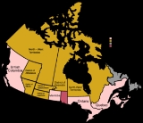
Districts of Northwest Territories
Encyclopedia
The vastness of Canada
's Northwest Territories
(spelled 'North-West Territories' from 1870 to 1905) meant that for much of its history it was divided into several districts for ease of administration. The number and size of these territorial districts varied as other provinces and territories of Canada
were created and expanded. The districts of the Northwest Territories were abolished in 1999 with the creation of Nunavut
territory and the contraction of the Northwest Territories to its current size.
In 1870 Canada gained control of the Rupert's Land
and the North-Western Territory
from the Hudson's Bay Company
. That same year, a small piece of Rupert's Land was formed into the province of Manitoba
, but the rest of the area was merged and renamed the North-West Territories. This region included the vast bulk of Canada's present day landmass and covered an area about the size of western Europe
.
In 1876 the North-West Territories contracted in size when a large area of 590932 km² (228,160.1 sq mi), between Manitoba and Ontario
and along the entire west coast of Hudson Bay
, was established by Canada as a territory named the District of Keewatin
. This autonomous territory is not to be confused with the 'districts' which would later be created within the North-West Territories.
In 1880 the Canadian Arctic Archipelago
was ceded to Canada by the United Kingdom
and this land was added to the North-West Territories.
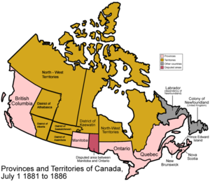 As the southern part of the North-West Territories became populated, four districts were created in 1882 for ease of administration; unlike Keewatin, these areas remained a part of the North-West Territories, and thus were formally called provisional districts:
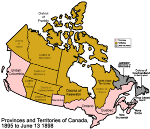 In 1895 the northern portion of the North-West Territories was divided into four more internal districts for ease of administration.:
necessitated the conversion of the District of Yukon into the autonomous Yukon Territory.
The three remaining districts continued to be used for a number of decades, but as control over the territory was moved from departments of the federal government to a centralized government in Yellowknife, they began to have far less use. Although the Districts of Franklin, Mackenzie and Keewatin continued to appear on many maps, the governance of the Northwest Territories was divided into four administrative regions: Inuvik
, Fort Smith
, Keewatin
and Baffin
. A fifth region, the Central Arctic Region and subsequently called the Kitikmeot
, was later carved out of the Fort Smith Region.
. The former District of Keewatin, most of the Arctic Islands of the District of Franklin, and a northwest portion of the District of Mackenzie now form Nunavut, with the remainder of Franklin and the majority of Mackenzie forming the current version of the Northwest Territories.
Canada
Canada is a North American country consisting of ten provinces and three territories. Located in the northern part of the continent, it extends from the Atlantic Ocean in the east to the Pacific Ocean in the west, and northward into the Arctic Ocean...
's Northwest Territories
Northwest Territories
The Northwest Territories is a federal territory of Canada.Located in northern Canada, the territory borders Canada's two other territories, Yukon to the west and Nunavut to the east, and three provinces: British Columbia to the southwest, and Alberta and Saskatchewan to the south...
(spelled 'North-West Territories' from 1870 to 1905) meant that for much of its history it was divided into several districts for ease of administration. The number and size of these territorial districts varied as other provinces and territories of Canada
Provinces and territories of Canada
The provinces and territories of Canada combine to make up the world's second-largest country by area. There are ten provinces and three territories...
were created and expanded. The districts of the Northwest Territories were abolished in 1999 with the creation of Nunavut
Nunavut
Nunavut is the largest and newest federal territory of Canada; it was separated officially from the Northwest Territories on April 1, 1999, via the Nunavut Act and the Nunavut Land Claims Agreement Act, though the actual boundaries had been established in 1993...
territory and the contraction of the Northwest Territories to its current size.
North-West Territories pre-'districts'
The North-West Territories were administered as a single entity, with no districts, from 1870 to 1882.In 1870 Canada gained control of the Rupert's Land
Rupert's Land
Rupert's Land, or Prince Rupert's Land, was a territory in British North America, consisting of the Hudson Bay drainage basin that was nominally owned by the Hudson's Bay Company for 200 years from 1670 to 1870, although numerous aboriginal groups lived in the same territory and disputed the...
and the North-Western Territory
North-Western Territory
The North-Western Territory was a region of British North America until 1870. Named for where it lay in relation to Rupert's Land, the territory at its greatest extent covered what is now Yukon, mainland Northwest Territories, northwestern mainland Nunavut, northwestern Saskatchewan, northern...
from the Hudson's Bay Company
Hudson's Bay Company
The Hudson's Bay Company , abbreviated HBC, or "The Bay" is the oldest commercial corporation in North America and one of the oldest in the world. A fur trading business for much of its existence, today Hudson's Bay Company owns and operates retail stores throughout Canada...
. That same year, a small piece of Rupert's Land was formed into the province of Manitoba
Manitoba
Manitoba is a Canadian prairie province with an area of . The province has over 110,000 lakes and has a largely continental climate because of its flat topography. Agriculture, mostly concentrated in the fertile southern and western parts of the province, is vital to the province's economy; other...
, but the rest of the area was merged and renamed the North-West Territories. This region included the vast bulk of Canada's present day landmass and covered an area about the size of western Europe
Western Europe
Western Europe is a loose term for the collection of countries in the western most region of the European continents, though this definition is context-dependent and carries cultural and political connotations. One definition describes Western Europe as a geographic entity—the region lying in the...
.
In 1876 the North-West Territories contracted in size when a large area of 590932 km² (228,160.1 sq mi), between Manitoba and Ontario
Ontario
Ontario is a province of Canada, located in east-central Canada. It is Canada's most populous province and second largest in total area. It is home to the nation's most populous city, Toronto, and the nation's capital, Ottawa....
and along the entire west coast of Hudson Bay
Hudson Bay
Hudson Bay , sometimes called Hudson's Bay, is a large body of saltwater in northeastern Canada. It drains a very large area, about , that includes parts of Ontario, Quebec, Saskatchewan, Alberta, most of Manitoba, southeastern Nunavut, as well as parts of North Dakota, South Dakota, Minnesota,...
, was established by Canada as a territory named the District of Keewatin
District of Keewatin
The District of Keewatin was a territory of Canada and later an administrative district of the Northwest Territories.The name "Keewatin" comes from Algonquian roots—either kīwēhtin in Cree or giiwedin in Ojibwe—both of which mean north wind in their respective languages...
. This autonomous territory is not to be confused with the 'districts' which would later be created within the North-West Territories.
In 1880 the Canadian Arctic Archipelago
Canadian Arctic Archipelago
The Canadian Arctic Archipelago, also known as the Arctic Archipelago, is a Canadian archipelago north of the Canadian mainland in the Arctic...
was ceded to Canada by the United Kingdom
United Kingdom of Great Britain and Ireland
The United Kingdom of Great Britain and Ireland was the formal name of the United Kingdom during the period when what is now the Republic of Ireland formed a part of it....
and this land was added to the North-West Territories.
1882
- The District of AlbertaDistrict of AlbertaThe District of Alberta was one of four districts of the Northwest Territories created in 1882. It was styled the Alberta Provisional District to distinguish it from the District of Keewatin which had a more autonomous relationship from the NWT administration...
was where the southwestern part of the province of AlbertaAlbertaAlberta is a province of Canada. It had an estimated population of 3.7 million in 2010 making it the most populous of Canada's three prairie provinces...
is today, east of British ColumbiaBritish ColumbiaBritish Columbia is the westernmost of Canada's provinces and is known for its natural beauty, as reflected in its Latin motto, Splendor sine occasu . Its name was chosen by Queen Victoria in 1858...
, west of the line between ranges 10 and 11 of the Dominion Land SurveyDominion Land SurveyThe Dominion Land Survey is the method used to divide most of Western Canada into one-square-mile sections for agricultural and other purposes. It is based on the layout of the Public Land Survey System used in the United States, but has several differences...
(about 112° west) and north of the AmericanUnited StatesThe United States of America is a federal constitutional republic comprising fifty states and a federal district...
border. - The District of AthabascaDistrict of AthabascaThe District of Athabasca is a former district of Canada. Its northern boundary was the current southern boundary of the Northwest Territories and extended south to 55° north latitude. The westernmost part is now part of Alberta and most of the eastern part is now in Saskatchewan. The very...
covered the northern half of what is today Alberta. - The District of Assiniboia was where the southernmost quarter of SaskatchewanSaskatchewanSaskatchewan is a prairie province in Canada, which has an area of . Saskatchewan is bordered on the west by Alberta, on the north by the Northwest Territories, on the east by Manitoba, and on the south by the U.S. states of Montana and North Dakota....
is today (south of the Ninth Correction Line, about 51.97° north), but stretched somewhat further west into what is today Alberta. - The District of SaskatchewanDistrict of SaskatchewanThe District of Saskatchewan was a regional administrative district of Canada's Northwest Territories. Much of the area was incorporated into the province of Saskatchewan. The western part became part of Alberta, and the eastern part is now part of Manitoba. Its capital was Prince Albert...
was to the north of Assiniboia extending halfway up modern Saskatchewan. It stretched further east than Assiniboia, running all the way to the shore of Lake WinnipegLake WinnipegLake Winnipeg is a large, lake in central North America, in the province of Manitoba, Canada, with its southern tip about north of the city of Winnipeg...
and the Nelson RiverNelson RiverThe Nelson River is a river of north-central North America, in the Canadian province of Manitoba. Its full length is , it has mean discharge of , and has a drainage basin of , of which is in the United States...
. It also stretched west into what is now Alberta.
1895
- The District of FranklinDistrict of FranklinThe District of Franklin was a regional administrative district of Canada's Northwest Territories. The district consisted of the Canadian high Arctic Islands, notably Ellesmere Island, Baffin Island, and Victoria Island...
was made up of the Arctic islands. - The District of UngavaDistrict of UngavaThe District of Ungava was a regional administrative district of Canada's Northwest Territories from 1895 to 1912. It covered the northern portion of what is today Quebec, the interior of Labrador and the offshore islands to the west and north, which are now part of the Nunavut.The continental...
was made up of what is today northern QuebecQuebecQuebec or is a province in east-central Canada. It is the only Canadian province with a predominantly French-speaking population and the only one whose sole official language is French at the provincial level.... - The District of Yukon was made up of what is today the YukonYukonYukon is the westernmost and smallest of Canada's three federal territories. It was named after the Yukon River. The word Yukon means "Great River" in Gwich’in....
. - The District of MackenzieDistrict of MackenzieThe District of Mackenzie was a regional administrative district of Canada's Northwest Territories. The district consisted of the portion of the Northwest Territories directly north of British Columbia, Alberta, and Saskatchewan on Canada's mainland....
was the rest, stretching from the Yukon border in the west to the Keewatin border in the east, and containing none of the islands. - The District of AthabascaDistrict of AthabascaThe District of Athabasca is a former district of Canada. Its northern boundary was the current southern boundary of the Northwest Territories and extended south to 55° north latitude. The westernmost part is now part of Alberta and most of the eastern part is now in Saskatchewan. The very...
expanded and covered the northern half of what is today both Alberta and Saskatchewan.
1898
The North-West Territories shrunk in 1898 when the Klondike Gold RushKlondike Gold Rush
The Klondike Gold Rush, also called the Yukon Gold Rush, the Alaska Gold Rush and the Last Great Gold Rush, was an attempt by an estimated 100,000 people to travel to the Klondike region the Yukon in north-western Canada between 1897 and 1899 in the hope of successfully prospecting for gold...
necessitated the conversion of the District of Yukon into the autonomous Yukon Territory.
1905
The North-West Territories experienced significant adjustments in 1905:- The Districts of Alberta, Assiniboia, Athabaska, and Saskatchewan were reorganized to form the provinces of Alberta and Saskatchewan.
- The original independent territory 'District of Keewatin', which had shrunk considerably from its 1876 size as large portions of its area had been converted into the expansion of Manitoba and Ontario, gave up its autonomy and became a district within the North-West Territories.
- A small eastern portion of the (now) defunct Districts of Saskatchewan and Athabaska were added to the District of Keewatin.
- A portion of the District of Mackenzie was added to the District of Keewatin.
- The hyphen was removed from North-West Territories, so that the area was now named the Northwest Territories.
- The Northwest Territories now consisted of the Districts of Franklin, Ungava, Mackenzie and Keewatin.
1912
The Northwest Territories experienced further attrition in 1912:- The entire District of Ungava was converted into the northern expansion of the province of Quebec
- Most of the District of Keewatin was converted into the northern expansion of the provinces of Ontario and Manitoba.
- The Northwest Territories now consisted of the Districts of Franklin, Mackenzie and Keewatin.
The three remaining districts continued to be used for a number of decades, but as control over the territory was moved from departments of the federal government to a centralized government in Yellowknife, they began to have far less use. Although the Districts of Franklin, Mackenzie and Keewatin continued to appear on many maps, the governance of the Northwest Territories was divided into four administrative regions: Inuvik
Inuvik Region, Northwest Territories
The Inuvik Region is one of five administrative regions in the Northwest Territories. The region consists of eight communities with the regional office situated in Inuvik...
, Fort Smith
Fort Smith Region, Northwest Territories
Fort Smith Region is one of Statistics Canada's two census divisions of the Northwest Territories, Canada. It contains more than 77 percent of the population and more than 54 percent of the land area of the Northwest Territories. Its main economic centre is the territorial capital of Yellowknife...
, Keewatin
Keewatin Region, Northwest Territories
The Keewatin Region was a region of the Northwest Territories, in use as an administrative and statistical division until the creation of Nunavut in 1999...
and Baffin
Baffin Region, Northwest Territories
The Baffin Region was a region of the Northwest Territories, in use as an administrative and statistical division until the creation of Nunavut in 1999. The large majority of Baffin Region fell on the Nunavut side of the boundary and was reconstituted within the new territory as the Qikiqtaaluk...
. A fifth region, the Central Arctic Region and subsequently called the Kitikmeot
Kitikmeot Region, Northwest Territories
The Kitikmeot Region was part of the Northwest Territories until division in April 1999 when most of the region became part of Nunavut. It consisted of Victoria Island with the adjacent part of the mainland as far as the Boothia Peninsula, together with King William Island and the southern portion...
, was later carved out of the Fort Smith Region.
1999
In 1999 the Northwest Territories was reduced to its current size - and the notion of the 'districts' was abolished - with the creation of the Canadian territory of NunavutNunavut
Nunavut is the largest and newest federal territory of Canada; it was separated officially from the Northwest Territories on April 1, 1999, via the Nunavut Act and the Nunavut Land Claims Agreement Act, though the actual boundaries had been established in 1993...
. The former District of Keewatin, most of the Arctic Islands of the District of Franklin, and a northwest portion of the District of Mackenzie now form Nunavut, with the remainder of Franklin and the majority of Mackenzie forming the current version of the Northwest Territories.
See also
- Former colonies and territories in CanadaFormer colonies and territories in CanadaFormer colonies, territories, boundaries, and claims in Canada prior to the current classification of provinces and territories. In North America, ethnographers commonly classify Aboriginals into ten geographical regions with shared cultural traits and by related linguistic dialects...
- Territorial evolution of CanadaTerritorial evolution of CanadaThe federation of Canada was created in 1867 when three colonies of British North America were united. One of these colonies split into two new provinces, three other colonies joined later...
- Politics of Northwest TerritoriesPolitics of Northwest TerritoriesThe Politics of Northwest Territories involves not only the governance of the Northwest Territories but also the social, economic and political issues specific to the territory...
- History of the Northwest Territories
- History of Northwest Territories capital citiesHistory of Northwest Territories capital citiesThe history of Northwest Territories capital cities begins with the purchase of the Territories by Canada from the Hudson's Bay Company in 1869 and includes a varied and often difficult evolution. Northwest Territories is unique amongst the other provinces and territories of Canada in that it has...
- Council of KeewatinCouncil of KeewatinThe Council of Keewatin was an unelected legislative body and territorial government for the now-defunct District of Keewatin in Canada. The District of Keewatin was created by the passage of the Keewatin Act on April 12, 1876 from a portion of Canada's North West Territories...
- List of Northwest Territories Legislative Assemblies