
Fairhaven, Saskatoon
Encyclopedia
| City of Saskatoon Neighbourhoods | |
|---|---|
| Fairhaven | |
| Confederation Suburban Development Area | |
 |
|
| Population: | 4,990 |
| Average Family Income: | $47,591 |
| Average Household Size: | 2.6 |
| Homeownership: | 49.9% |
| Average Home Selling Price: | $108,106 |
| Municipal Ward: | 3 |
| Statistics c2005 - | |
Fairhaven is a neighbourhood in Saskatoon
Saskatoon
Saskatoon is a city in central Saskatchewan, Canada, on the South Saskatchewan River. Residents of the city of Saskatoon are called Saskatonians. The city is surrounded by the Rural Municipality of Corman Park No. 344....
, Saskatchewan
Saskatchewan
Saskatchewan is a prairie province in Canada, which has an area of . Saskatchewan is bordered on the west by Alberta, on the north by the Northwest Territories, on the east by Manitoba, and on the south by the U.S. states of Montana and North Dakota....
, Canada. It is close to both Catholic and public elementary schools. A strip mall
Strip mall
A strip mall is an open-area shopping center where the stores are arranged in a row, with a sidewalk in front. Strip malls are typically developed as a unit and have large parking lots in front...
is within the Fairhaven subdivision. The Confederation Suburban Centre is to the north.
History
The community of Fairhaven first appeared on city mapCity map
A city map is a large-scale thematic map of a city created to enable the fastest possible orientation in an urban space. The graphic representation of objects on a city map is therefore usually greatly simplified, and reduced to generally understood symbology.Depending upon its target group or...
s circa 1971, and the layout of streets in the community underwent several revisions before development began in earnest in the mid-1970s, with most construction in the area complete by 1985, however there remains some undeveloped lots on the community's eastern periphery as of 2007, which have since been filled with the relocation of six-plex homes from the former McNab Park neighborhood.
Sarah Shatwell Pendygrasse arrived from England in 1887 and was awarded a dominion land grant patent at SE section 20 township 36 range 5 W of the 3rd meridian
106th meridian west
The meridian 106° west of Greenwich is a line of longitude that extends from the North Pole across the Arctic Ocean, North America, the Pacific Ocean, the Southern Ocean, and Antarctica to the South Pole....
, Saskatchewan provisional district, North West Territories on December 12, 1892. Her son Harold L. S. Pendygrasse homestead at NE Section 20 township 35 Range 3 W of the 3rd meridian. At 1919 St. Henry Avenue, Exhibition subdivision the Pendygrasse Home built by Harold Pendygrasse in 1910 has been declared a municipal heritage site. It is built on the banks of the South Saskatchewan river east side of Saskatoon.
When Fairhaven first appeared on the maps, the street names all had one thing in common: they all started with the letter F. When the community was re-plotted in the mid-1970s, this was abandoned (except for Fairlight Drive and Fairmont Drive) and most other streets in the area were named for prominent city officials of the past, such as former city councillors S.E. Bushe, E.H. Crimp, G.A. Forrester, J.J. Olmstead, and James Priel.
When the community of Parkridge was first planned to the west of Fairhaven, it was identified on maps as "Fairhaven II" or "Fairhaven West" until a unique name was given to the area.
Education
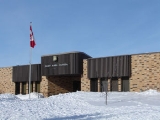
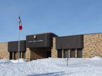
- St. Mark School Separate Elementary School
- Fairhaven School Public Elementary School
Area parks
- Herbert S. Sears Park 20.87 acres Herbert S. (Bert) Sears (1907-1993) was a mayor of Saskatoon 1972-76.
Layout
Fairmont Drive provides the eastern boundary of Fairhaven. Fairlight Drive arcs above to the north as well as the western edge. Lochrie Crescent and Barber Place, Terrace, and Court are connected to Pendygrasse road and are included within the southern perimeter of Fairhaven. The Canadian Pacific Railway delimits the southern edge. Prior to the construction of the Circle Drive and 22nd Street interchange, motorists were able to access the MeadowgreenMeadowgreen, Saskatoon
Meadowgreen community is a geographically localized subdivision of the Confederation Suburban Development Area in the city of Saskatoon, Saskatchewan, Canada. Meadowgreen is surrounded by an abundance of green space and walking trails without being a River side neighbourhood. The buffer zone...
neighborhood via Clancy Drive through a signalized grade crossing intersection at 18th Street and Circle Drive. When the initial plan called for the interchange having no access to eastbound 22nd Street from southbound Circle Drive, a re-drawing saw the western leg of Camponi Crescent and northbound Fairmont Drive become part of the interchange with access to 18th Street via Clancy Drive ceasing to exist, the signalized grade crossing intersection at Circle Drive and Clancy Drive remains as it was reconfigured to a layout similar to that of the intersection of Circle Drive & Laurier Drive following the closure of 18th Street. However if an overpass is proposed at Circle & Clancy, 18th Street could possibly be reconnected.
Life
Fairhaven Community Association provides recreational activities at both St. Mark and Fairhaven school, as well as using the common green space between them provided by Herbert S. Sears Park.Location
| North: Confederation Suburban Centre | ||
| West: Parkridge | Fairhaven | East: Confederation Suburban Centre |
| South: AgPro Industrial | Montgomery Place |