
Mayfair, Saskatoon
Encyclopedia
Mayfair is currently a neighborhood in the city
of Saskatoon
, Saskatchewan
, Canada
. Mayfair started out as a community outside of the villages of Riversdale, Nutana and Saskatoon and appears as its own place name on a map of 1907. In 1909 there were 60 residences built in Mayfair, and in 1911, the City of Saskatoon had grown large enough to encompass Mayfair. Homeownership amongst the residents is at 68.2%, with an average home selling price in 2006 of $78.757.
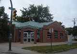
Prior to the completion of the first stage of Mayfair School, pupils of the district were accommodated in temporary frame structures. The basement for the brick school at Mayfair had been completed in 1914. However, further progress on construction was not resumed until six years later. In January 1919, the Board realized that the use of the framed buildings would no longer meet the accommodation needs of the Mayfair district. Tenders were called for the completion of the permanent structure. A. W. Cassidy and Company was offered the contract, and work commenced in August of that year. The amount of the tender and sub-trades was a total of $212,484.00. This first stage of the building structure provided ten classrooms.
In 1952 an addition of four classrooms and an auditorium, was completed in 1952 at a total cost of $133,393.00.
Building plans for the 1958-59 school year provided for an addition of four classrooms at Mayfair school. Architects, Webster, Forrester and Scott, and contractor W.C. Wells, were involved in the project which was opened in September 1959.
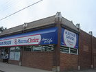 Shopping lines both sides of 33rd Street East.
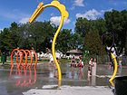
The park was built on land acquired by the City of Saskatoon for non-payment of taxes, It is located on 37th St. between Avenues D and F. It is a legacy of the pre-war boom and bust as land speculators found themselves unable to sell off their properties and in many cases simply allowed ownership to revert to the City.
The east half of the park (including the paddling pool) was built in 1955. In 1957 part of Avenue E was closed north of 37th and the park was extended west to Avenue F. Previously known informally as "Mayfair Park", it was now formally named in honour of long-time Parks Superintendent Alfred H. Browne. In 1980, with funding provided by the Mayfair Neighbourhood Improvement Plan (NIP) it was re-landscaped. A hill was built in the center, the ball diamond was moved and expanded and new playgrounds, a soccer pitch and basketball court were built.
has had many titles: Avenue A, (Highway 11
and most currently Louis Riel Trail). It is a main thoroughfare through the city connecting Regina
, Saskatoon
and Prince Albert, Saskatchewan
. It also connects west Saskatoon with the bedroom communities of Warman
and Martensville
City
A city is a relatively large and permanent settlement. Although there is no agreement on how a city is distinguished from a town within general English language meanings, many cities have a particular administrative, legal, or historical status based on local law.For example, in the U.S...
of Saskatoon
Saskatoon
Saskatoon is a city in central Saskatchewan, Canada, on the South Saskatchewan River. Residents of the city of Saskatoon are called Saskatonians. The city is surrounded by the Rural Municipality of Corman Park No. 344....
, Saskatchewan
Saskatchewan
Saskatchewan is a prairie province in Canada, which has an area of . Saskatchewan is bordered on the west by Alberta, on the north by the Northwest Territories, on the east by Manitoba, and on the south by the U.S. states of Montana and North Dakota....
, Canada
Canada
Canada is a North American country consisting of ten provinces and three territories. Located in the northern part of the continent, it extends from the Atlantic Ocean in the east to the Pacific Ocean in the west, and northward into the Arctic Ocean...
. Mayfair started out as a community outside of the villages of Riversdale, Nutana and Saskatoon and appears as its own place name on a map of 1907. In 1909 there were 60 residences built in Mayfair, and in 1911, the City of Saskatoon had grown large enough to encompass Mayfair. Homeownership amongst the residents is at 68.2%, with an average home selling price in 2006 of $78.757.
Location
Within the Lawson Suburban Development Area (West Side), the neighbourhood of Mayfair is bounded to the south by 33rd Street East, the north by Circle Drive. The width is determined by Idylwyld Drive (Avenue A) and Avenue H.History
Mayfair Streets in 1912 were named differently.- 33rd Street East was previously named “Albert”
- 34th Street East was previously named “James”
- 35th Street East was previously named“Charles”
- 36th Street East was previously named “Lily”
- 37th Street East was previously named “Frisco”
- Book about Mayfair: City of Saskatoon Planning Dept. Mayfair: a Plan for Neighborhood Improvement
Layout
Streets are laid out east and west, avenues are laid out running north and south. Streets increment in number as travel heads northward. Avenues increment alphabetically as travel proceeds west. The whole of the Mayfair community is also laid out in a grid pattern.Education
- Mayfair School Public Elementary School opened January, 1921.
Prior to the completion of the first stage of Mayfair School, pupils of the district were accommodated in temporary frame structures. The basement for the brick school at Mayfair had been completed in 1914. However, further progress on construction was not resumed until six years later. In January 1919, the Board realized that the use of the framed buildings would no longer meet the accommodation needs of the Mayfair district. Tenders were called for the completion of the permanent structure. A. W. Cassidy and Company was offered the contract, and work commenced in August of that year. The amount of the tender and sub-trades was a total of $212,484.00. This first stage of the building structure provided ten classrooms.
In 1952 an addition of four classrooms and an auditorium, was completed in 1952 at a total cost of $133,393.00.
Building plans for the 1958-59 school year provided for an addition of four classrooms at Mayfair school. Architects, Webster, Forrester and Scott, and contractor W.C. Wells, were involved in the project which was opened in September 1959.
Shopping
- Mayfair Hardware opened June 1949
- Christie's Mayfair Bakery opened 1933
- Safeway Inc.Safeway Inc.Safeway Inc. , a Fortune 500 company, is North America's second largest supermarket chain after The Kroger Co., with, as of December 2010, 1,694 stores located throughout the western and central United States and western Canada. It also operates some stores in the Mid-Atlantic region of the Eastern...
- Mayfair Sporting Goods Inc.
Area Parks
- A.H. Browne Park 4.83 acres (19,546.3 m²). The park features a seasonal water park/padding pool, baseball diamond, tobaggon hill, and soccer/football field.
The park was built on land acquired by the City of Saskatoon for non-payment of taxes, It is located on 37th St. between Avenues D and F. It is a legacy of the pre-war boom and bust as land speculators found themselves unable to sell off their properties and in many cases simply allowed ownership to revert to the City.
The east half of the park (including the paddling pool) was built in 1955. In 1957 part of Avenue E was closed north of 37th and the park was extended west to Avenue F. Previously known informally as "Mayfair Park", it was now formally named in honour of long-time Parks Superintendent Alfred H. Browne. In 1980, with funding provided by the Mayfair Neighbourhood Improvement Plan (NIP) it was re-landscaped. A hill was built in the center, the ball diamond was moved and expanded and new playgrounds, a soccer pitch and basketball court were built.
Transportation
Idylwyld DriveIdylwyld Drive
Idylwyld Drive is an arterial road in Saskatoon, Saskatchewan. It is one of the main roads in and out of the downtown area of the city.On the south side of the Senator Sid Buckwold Bridge, it is a freeway and is known as the Idylwyld Freeway. It eventually turns into Circle Drive, just east of...
has had many titles: Avenue A, (Highway 11
Saskatchewan Highway 11
Highway 11 is a major north-south highway in Saskatchewan, Canada that connects the province's three largest cities: Regina, Saskatoon and Prince Albert. It is a structural pavement major arterial highway which is approximately long. It is also known as the Louis Riel Trail after the 19th century...
and most currently Louis Riel Trail). It is a main thoroughfare through the city connecting Regina
Regina, Saskatchewan
Regina is the capital city of the Canadian province of Saskatchewan. The city is the second-largest in the province and a cultural and commercial centre for southern Saskatchewan. It is governed by Regina City Council. Regina is the cathedral city of the Roman Catholic and Romanian Orthodox...
, Saskatoon
Saskatoon
Saskatoon is a city in central Saskatchewan, Canada, on the South Saskatchewan River. Residents of the city of Saskatoon are called Saskatonians. The city is surrounded by the Rural Municipality of Corman Park No. 344....
and Prince Albert, Saskatchewan
Prince Albert, Saskatchewan
Prince Albert is the third-largest city in Saskatchewan, Canada. It is situated in the centre of the province on the banks of the North Saskatchewan River. The city is known as the "Gateway to the North" because it is the last major centre along the route to the resources of northern Saskatchewan...
. It also connects west Saskatoon with the bedroom communities of Warman
Warman, Saskatchewan
-History:The town of Warman was born when the Canadian National Railway running from Humboldt to North Battleford intersected with the Canadian Pacific Railway running from Regina to Prince Albert. This took place in the fall of 1904....
and Martensville
Martensville, Saskatchewan
Martensville is a city located in Saskatchewan, Canada, just north of Saskatoon, and south west of Clarkboro Ferry which crosses the South Saskatchewan River. Martensville is one of the fastest growing communities in Saskatchewan, with the population growing 25% between 1996 and 2001. It is...
Life
Kelsey Community Association provides leisure activities for various age groups and they are made available for area residents at Mayfair community school.Location
| North: Airport Business Area | ||
| West: Hudson Bay Park | Mayfair Mayfair Mayfair is an area of central London, within the City of Westminster.-History:Mayfair is named after the annual fortnight-long May Fair that took place on the site that is Shepherd Market today... | East: Kelsey-Woodlawn |
| South: Caswell Hill |