
Parkridge, Saskatoon
Encyclopedia
| City of Saskatoon Neighbourhoods | |
|---|---|
| Parkridge | |
| Confederation Suburban Development Area | |
 |
|
| Population: | 4,500 |
| Average Family Income: | $58,944 |
| Average Household Size: | 3.2 |
| Homeownership: | 72.0% |
| Average Home Selling Price: | $124,107 |
| Municipal Ward: | 3 |
| Statistics c2005 - | |

Saskatoon
Saskatoon is a city in central Saskatchewan, Canada, on the South Saskatchewan River. Residents of the city of Saskatoon are called Saskatonians. The city is surrounded by the Rural Municipality of Corman Park No. 344....
, Saskatchewan
Saskatchewan
Saskatchewan is a prairie province in Canada, which has an area of . Saskatchewan is bordered on the west by Alberta, on the north by the Northwest Territories, on the east by Manitoba, and on the south by the U.S. states of Montana and North Dakota....
, located on land annexed by the city between 1975 and 1979. Development of the subdivision (initially called "Fairhaven II" after the neighbouring community to the east, began in the early 1980s and as of 2007 the community remains incomplete, with the extreme western end remaining undeveloped (however construction of this final phase is expected to coincide with development of the adjacent Blairmore Suburban Centre). Whereas the majority of residents are employed in the sales and service sector, the next highest employer is business, finance and administration. The two main age groups are those in their 40's and teenagers as of 2005. Until recently Parkridge was the farthest western neighbourhood of Saskatoon south of 22nd Street. However, new construction will soon see Neighbourhood 2 of the Blairmore SDA bear that claim to fame. In comparison the neighbourhood of Parkridge with a 2001 census population of 4,505 is larger than the Saskatchewan city of Melville
Melville, Saskatchewan
Melville is a small Canadian city located in the east-central portion of Saskatchewan. It was declared a city by the province in 1960. The city is north east of the provincial capital of Regina and south west of Yorkton. According to The World Gazetteer, it has a 2004 population of approximately...
which had a population of 4,149 in 2006, and 4,453 in 2001 and Parkridge is a little smaller than the provincial city of Humboldt
Humboldt, Saskatchewan
Humboldt is a Canadian city located in the province of Saskatchewan, 113 km east of Saskatoon at the junction of Highway 5 and Highway 20. The city is surrounded by the Rural Municipality of Humboldt No...
which was 4,998 in 2006, and 5,161 in 2001. In Saskatchewan rural towns must maintain a population above 5,000 to apply for city status.
History
The roadways are to the most part named after those people who contributed significantly to the City of Saskatoon.| List of Parkridge Roadways | ||
|---|---|---|
| Street Name | Resident | Contribution |
| Postnikoff Cres. | ||
| Grooper Cres. | ||
| Blue Place | ||
| Poth Way, Cres. | ||
| Gooding Pl, Cres. | ||
| Heise Cres. | ||
| Fairburn Crt | ||
| Fusedale Terr. | ||
| Needham Cres., Way | Needham, C.A. (1928–1929) | City councillor |
| Neatby Cres., Pl. | Hilda Neatby | Head of the Dept. of History (1958–69) |
| Podiluk Crt. | Dr. Walter Podiluk, C.M., LL.D. (Hon.) | Saskatoon Catholic schools board of Education |
| Strumm Terr. | Strumm, Gil | Saskatoon Sports Hall of Fame in 1986. |
| Cory Pl. | ||
| Arrand Cres. | James and Walter Arrand | Saskatoon contractors |
| Batoche Cr. | Xavier Letendre dit Batoche | Village founder |
| Blackley Pl. | David Blackley | Temperance Colony Pioneer |
| Skuce Pl. | ||
| Caldwell Pl. Crt. Cres. | Jessie Caldwell, B.Sc. | Canadian Achiever by the Government of Canada |
| Smith Cr., Pl., Road | ||
| Borland Pl. | ||
| Whitecap Terr. Pl. Cres. | Chief Whitecap (Wapahska) | Friend and guide of Saskatoon founder John Lake |
| Sherry Cres., Way, Pl. Crt. | ||
| McCormack Road | ||
| Wrigley Cres. | James Brooke Wrigley; Eleanor Wrigley | real estate business, J.P. & etc. |
| Streb Cres. Way | ||
| Statistics c2005 - | ||
Education
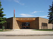
- James L. Alexander School Public Elementary School
- St. Marguerite School Separate Elementary School
City Transit
Parkridge is serviced by three Saskatoon TransitSaskatoon Transit
Saskatoon Transit is the public transport arm of the City of Saskatoon, Saskatchewan, Canada. It operates a fleet of diesel buses. A total of 23 bus routes serve every area of the city, carrying approximately 11 million passengers in 2008...
routes: Route #3 (Riversdale/College Park services the neighborhood boundary on Fairlight Drive while Route #5 (Fairhaven/Briarwood) services McCormack Road and Route #22 (McCormack Rd./City Centre) also services McCormack during peak hours.
Layout
Saskatchewan Highway 7
Saskatchewan Highway 7 is a major paved undivided provincial highway in the Canadian province of Saskatchewan, running from the Alberta border to Saskatoon...
. 22nd Street
Saskatchewan Highway 14
Highway 14 is a highway in the Canadian province of Saskatchewan. It runs from the intersection of Idylwyld Drive and 22nd Street in downtown Saskatoon, westward to the Albertan border where it becomes Highway 13. It is approximately 261 km long.Prior to the 1970's, Highway 14 ran the width...
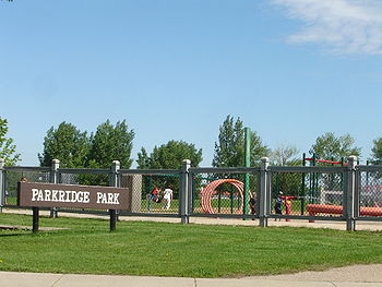
is the northern most limit for this neighbourhood. CPR rail line is as far south as this neighbourhood will venture. Fairlight Drive creates a cruved eastern boundary. The neighbourhood is of uneven shape, and even though there are main thoroughfares west, south and north, the community nestles around Parkridge Park with courts and crescents. Parkridge Park is centrally located with James L Alexander School at the north end, and Sainte Marguerite School at the southern edge of the park. The community's main access road, McCormack Road, winds through the district, including the extreme western portion that has been left undeveloped. Development of the far west end (specifically around Kinloch Crescent which has been on the maps for a quarter century without ever being constructed, technically leaving Kinloch a paper street
Paper street
A paper street is a road or street that appears on maps but does not exist in reality. Paper streets generally occur when city planners or subdivision developers lay out and dedicate streets that are never built...
) is expected to occur in conjunction with the opening of the adjacent Blairmore Suburban Centre. In 2009, the city honored a request to convert the Kinloch development from a crescent to two cul-de-sac
Cul-de-sac
A cul-de-sac is a word of French origin referring to a dead end, close, no through road or court meaning dead-end street with only one inlet/outlet...
streets.
Shopping
The neighbouring subdivision of Fairhaven hosts a few neighbourhood convenience stores, and a strip mall alongside Confederation Inn. Confederation Suburban Centre is nearby, and commercial development is expected to occur in the Blairmore Suburban Centre to the immediate north.Life
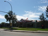
Parkridge Centre is a long term care facility for 240 resident who vary in age from pre-school to elderly.Location
| North: Pacific Heights | ||
| West: Blairmore SDA | Parkridge | East: Fairhaven |
| South: AgPro Industrial |