

Hazara Pakistan
Encyclopedia
Pakistan
Pakistan , officially the Islamic Republic of Pakistan is a sovereign state in South Asia. It has a coastline along the Arabian Sea and the Gulf of Oman in the south and is bordered by Afghanistan and Iran in the west, India in the east and China in the far northeast. In the north, Tajikistan...
. It comprises six districts: Abbottabad District
Abbottabad District
Abbottabad is a district in the Khyber Pakhtunkhwa province of Pakistan. The district covers an area of 1,969 km with the city of Abbottabad being the principal town...
, Battagram District, Haripur District
Haripur District
Haripur is a district in the Hazara region of Khyber-Pukhtunkhwa, province of Pakistan with an altitude of around above sea level. Haripur District has the highest Human Development Index of all the districts in the Hazara....
, Kohistan District, Mansehra District
Mansehra District
Mansehra District is in the Khyber Pakhtunkhwa province of Pakistan, an area still unofficially known as the Northwest Frontier. Mansehra district and town are named after Man Singh, a leading general of Mughal Emperor Akbar...
and now, since 28 January 2011, the new Tor Ghar District. It is dominated mainly by the Hindko-speaking
Hindko language
Hindko , also Hindku, or Hinko, is the sixth main regional language of Pakistan. It forms a subgroup of Indo-Aryan languages spoken by Hindkowans in Pakistan and northern India, some Pashtun tribes in Pakistan, as well as by the Hindki people of Afghanistan...
Hindkowan people, who are the native ethnic group of the region and often called the "Hazarewal
Hazarewal
Hazarewal or Hazarawal is another name or term for the Hindkowan people, a Hindko speaking community who belong to the Hazara region of Khyber Pakhtunkhwa ,Pakistan. The Hazarewal/Hindkowan/s are not to be confused with the ethnic Hazara people inhabiting parts of Baluchistan province in Pakistan...
."
Name
"The origin of the name Hazāra is obscure." This respected source continues: "It has been identified with Abisāra, the country of AbisaresAbisares
Abisares , called Embisarus by Diodorus, was an Indian king of abhira descent beyond the river Hydaspes, whose territory lay in the mountains, sent embassies to Alexander the Great both before and after the conquest of Porus in 326 BC, although inclined to espouse the side of the latter...
, the chief of the Indian mountaineers at the time of Alexander's invasion.
The name Hazara has also been derived from Urasā, or 'Urasha', an ancient Sanskrit
Sanskrit
Sanskrit , is a historical Indo-Aryan language and the primary liturgical language of Hinduism, Jainism and Buddhism.Buddhism: besides Pali, see Buddhist Hybrid Sanskrit Today, it is listed as one of the 22 scheduled languages of India and is an official language of the state of Uttarakhand...
name for this region, according to Prof. Aurel Stein. Some distinguished Indologists
Indology
Indology is the academic study of the history and cultures, languages, and literature of the Indian subcontinent , and as such is a subset of Asian studies....
including Dr H. C. Raychaudhury, Dr B. N. Mukerjee, Dr B. C. Law, Dr J. C. Vidyalankar, Dr M. Witzel, Dr M. R. Singh and Prof K. N. Dhar concur with Prof. Stein's identification of modern Hazara with ancient Urasa.
Evidence from the seventh century Chinese
China
Chinese civilization may refer to:* China for more general discussion of the country.* Chinese culture* Greater China, the transnational community of ethnic Chinese.* History of China* Sinosphere, the area historically affected by Chinese culture...
traveller Hiuen Tsang,
in combination with much earlier evidence from the celebrated Indian epic
Indian epic poetry
Indian epic poetry is the epic poetry written in the Indian subcontinent, traditionally called Kavya . The Ramayana and Mahabharata, originally composed in Sanskrit and translated thereafter into many other Indian languages, are some of the oldest surviving epic poems on earth and form part of...
, the Mahabharata
Mahabharata
The Mahabharata is one of the two major Sanskrit epics of ancient India and Nepal, the other being the Ramayana. The epic is part of itihasa....
, attests that Poonch and Hazara District of Kashmir
Kashmir
Kashmir is the northwestern region of the Indian subcontinent. Until the mid-19th century, the term Kashmir geographically denoted only the valley between the Great Himalayas and the Pir Panjal mountain range...
had formed parts of ancient state of Kamboja
Kambojas
The Kambojas were a kshatriya tribe of Iron Age India, frequently mentioned in Sanskrit and Pali literature.They were an Indo-Iranian tribe situated at the boundary of the Indo-Aryans and the Iranians, and appear to have moved from the Iranian into the Indo-Aryan sphere over time.The Kambojas...
, whose rulers followed a republican
Republicanism
Republicanism is the ideology of governing a nation as a republic, where the head of state is appointed by means other than heredity, often elections. The exact meaning of republicanism varies depending on the cultural and historical context...
form of government.
Although the region was called Hazara earlier, it was only made a district of that name, when under the British.
Alexander the Great and Ashoka
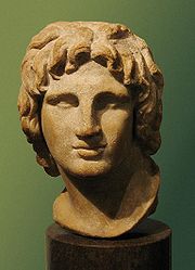
Abisares
Abisares , called Embisarus by Diodorus, was an Indian king of abhira descent beyond the river Hydaspes, whose territory lay in the mountains, sent embassies to Alexander the Great both before and after the conquest of Porus in 326 BC, although inclined to espouse the side of the latter...
(Αβισαρης), the Raja of Poonch state.
Hazara remained a part of the Taxila
Taxila
Taxila is a Tehsil in the Rawalpindi District of Punjab province of Pakistan. It is an important archaeological site.Taxila is situated about northwest of Islamabad Capital Territory and Rawalpindi in Panjab; just off the Grand Trunk Road...
administration during the rule of the Maurya dynasty. Ashoka the Great was the Governor of this area when he was a prince. After the death of his father Bindusara
Bindusara
Bindusara was the second Mauryan emperor after Chandragupta Maurya. During his reign, the empire expanded southwards. He had two well-known sons, Susima and Ashoka, who were the viceroys of Taxila and Ujjain...
around 272 B.C., Ashoka inherited the throne and ruled this area as well as Gandhara
Gandhara
Gandhāra , is the name of an ancient kingdom , located in northern Pakistan and eastern Afghanistan. Gandhara was located mainly in the vale of Peshawar, the Potohar plateau and on the Kabul River...
. Today, the Edicts of Ashoka inscribed on three large boulders near Bareri Hill serve as evidence of his rule here. The Mansehra rocks record fourteen of Ashoka's edicts, presenting aspects of the emperor's dharma or righteous law, and represent the earliest irrefutable evidence of writing in South Asia. Dating to middle of the third century BC, they are written from right to left in the Kharosthi script.
Hazara has several places of significance for the Hindu
Hindu
Hindu refers to an identity associated with the philosophical, religious and cultural systems that are indigenous to the Indian subcontinent. As used in the Constitution of India, the word "Hindu" is also attributed to all persons professing any Indian religion...
s related to the Pandavas.
In the 2nd century CE, a mythical king Raja Risalu, son of Raja Salbahan of Sialkot
Sialkot
Sialkot is a city in Pakistan situated in the north-east of the Punjab province at the foothills of snow-covered peaks of Kashmir near the Chenab river. It is the capital of Sialkot District. The city is about north-west of Lahore and only a few kilometers from Indian-controlled Jammu.The...
, supposedly brought the area under his control. The local people consider him as a popular folk hero. When a Chinese pilgrim, Hiun-Tsang
Xuanzang
Xuanzang was a famous Chinese Buddhist monk, scholar, traveler, and translator who described the interaction between China and India in the early Tang period...
, visited this area, it was under the control of Raja Durlabhavardhana, the ruler of Kashmir
Kashmir
Kashmir is the northwestern region of the Indian subcontinent. Until the mid-19th century, the term Kashmir geographically denoted only the valley between the Great Himalayas and the Pir Panjal mountain range...
.
The Shahi
Shahi
The Shahi , Sahi, also called Shahiya dynasties ruled one of the Middle kingdoms of India which included portions of the Kabulistan and the old province of Gandhara , from the decline of the Kushan Empire in the 3rd century to the early 9th century...
Dynasties ruled Hazara one after another. Among the Hindu Shahi dynasty rulers, Raja Jayapala
Jayapala
Jayapala Janjua Shahi, the son of Asatapala and father of Anandapal, was the first king and founder of the Hindushahi dynasty of Afghanistan and Northwest Pakistan. He succeeded the last Brahman Shahi king Bhimadeva in about 964 CE, and thus began the Janjua Rajput phase of Shahiya Dynasties...
is the best known. Mehmood of Ghazni
Mahmud of Ghazni
Mahmud of Ghazni , actually ', was the most prominent ruler of the Ghaznavid dynasty who ruled from 997 until his death in 1030 in the eastern Iranian lands. Mahmud turned the former provincial city of Ghazni into the wealthy capital of an extensive empire which covered most of today's Iran,...
defeated Raja Jayapala during his first campaign. However, there is no historical evidence that Mehmood of Ghazni ever visited or passed through Mansehra. After the fall of the Shahi dynasty, in the 11th century, the Kashmiris took control of this area under the leadership of Kalashan (1063 to 1089). From 1112 to 1120, King Susala ruled this area. In the 12th century, Asalat Khan captured this area but soon after Mohammad of Ghor's death the Kashmiris once again regained control of Hazara.
Amb
AMB
Amb may refer to:* Amb , a town in the Azad Kashmir, Pakistan* Amb, India, a town Himachal Pradesh, India* Amb , a region in the former Indian Empire* Amb special form, a nondeterministic programming construct using continuations...
and its surrounding areas of Hazara have a long history which can be traced to Alexander the Great's invasion of India. Arrian
Arrian
Lucius Flavius Arrianus 'Xenophon , known in English as Arrian , and Arrian of Nicomedia, was a Roman historian, public servant, a military commander and a philosopher of the 2nd-century Roman period...
, Alexander's historian, did not indicate the exact location of Embolina, but since it is known that Aoronos was on the right bank of the River Indus, the town chosen to serve as Alexander's base of supplies may with good reason be also looked for there. The mention in Ptolemy's Geography of Embolima as a town of Indo-Scythia situated on the Indus supports this theory.
In 1854 Major James Abbott, the British frontier officer from whom Abbottabad, administrative centre of Hazara, takes its name, discussed his location of Aornos on the Mahaban range south of Buner. He proposed, as M. Court, one of Ranjit Singh's French generals had done before him in 1839, to recognize Embolima in the present village of Amb situated on the right bank of the Indus. It lies about eight miles to the east of Mahaban and is the place from which the later Nawabs of Amb take their title.
Turk Rule
During the Mughal rule, the local Turkish chiefs acknowledged Mughal authority. In fact, Hazara (PakhliPakhli
Pakhli was an ancient sarkar of the Mughal Subah of Punjab, now part of Hazara, Pakistan. It roughly corresponds to the ancient Urasa, the Aρσa or Οΰaρσa which Ptolemy placed between the Bidaspes and the Indus....
) provided the main route to Kashmir and was the most commonly used route for Emperor Akbar to travel to Kashmir. During the last days of Emperor Akbar's rule, the Turkish Chief Sultan Hussain Khan revolted against the Mughals. He claimed that the Mughals were interfering with his internal affairs. After this complaint, he was exiled by the Mughals, but later was pardoned and given back some part of his lands.
In 1703, the Turk rule came to end and large number of Karlugh Turks migrated to nearby Kashmir. Today, the tribe has a very small population in Hazara but they are still considered an important caste in the area.
Durrani Rule
Hazara remained part of the Durrani AfghanAfghan
Afghan may refer to:* The country of Afghanistan, as abbreviated in reports as Afghan, or Afg.* Someone or something related to Afghanistan, see also Demography of Afghanistan* Afghan cuisine...
kingdom, from the mid-18th to the early 19th centuries. The lower Hazara plain was a separate administrative region attached to the Chacch and Attock areas of Northern Punjab
Punjab region
The Punjab , also spelled Panjab |water]]s"), is a geographical region straddling the border between Pakistan and India which includes Punjab province in Pakistan and the states of the Punjab, Haryana, Himachal Pradesh, Chandigarh and some northern parts of the National Capital Territory of Delhi...
whereas most of upper Hazara was attached to the Durrani 'Subah' or governorship of Kashmir
Kashmir
Kashmir is the northwestern region of the Indian subcontinent. Until the mid-19th century, the term Kashmir geographically denoted only the valley between the Great Himalayas and the Pir Panjal mountain range...
, with the exception of the Tanawal 'Ilaqa' or area, which enjoyed semi-independent status, with the Tanoli
Tanoli
The Tanoli are a Hazarewal tribe of the Tanawal valley, Hazara region of Khyber Pakhtunkhwa province of Pakistan. Although not usually acknowledged as Pashtuns, the Tanoli have to an extent assimilated many Pashtun cultural features and become Pashtunified. Tribally allied with the Pathans,. The...
leaders accepting token Durrani Rule and paying simple liege homage, at the same time looting the Durrani caravans which passed through Tanawal. The most important Tanoli chief then, Mir Navab Khan, fought the Durranis in a number of small battles and ultimately met his death at the hands of Sardar Azim Khan Durrani in 1818.
Sikh rule
DurraniDurrani
Durrani or Abdali is the name of a chief Pashtun tribal confederation in Afghanistan and Pakistan. Originally known by their ancient name Abdali later as Durrani they have been called Durrani since the beginning of the Durrani Empire in 1747. The number of Durranis are estimated to be roughly 16%...
rule had weakened considerably at the beginning of the 19th century. The Sikhs annexed Hazara in two stages. Lower Hazara except Karlal country became tributary to the Sikhs, with the exception of the ongoing struggle against the Sikhs led by the likes of Sardar Muhammad Khan Tarin, Shaheed, Bostan Khan Tarin and others of this tribe .Eventually, Ranjit Singh himself then attacked Hazara and reduced the warring tribes into submission, carrying the Tarin chief Muhammad Khan with him, as a prisoner, while the Karlals fled to the higher mountains for refuge; and the Sikhs were thus able to subdue the entire Lower Hazara . The Upper Hazara suffered a similar fate when the Sikhs took Kashmir
Kashmir
Kashmir is the northwestern region of the Indian subcontinent. Until the mid-19th century, the term Kashmir geographically denoted only the valley between the Great Himalayas and the Pir Panjal mountain range...
from the Barakzai Durranis in 1819, with the exception of the Tanawal area, under the leadership of Mir Painda Khan
Mir Painda Khan
Mir Painda Khan, was a powerful Tanoli chief, son of Mir Nawab Khan, famed for his rebellion against Maharaja Ranjit Singh's governors of Hazara. Painda Khan "played a considerable part in the history of his time and vigorously opposed the Sikhs."...
, who was the tribal chief of the Hindwal section of Tanolis at the time and kept up a staunch rebellion against Maharaja Ranjit Singh's Governors of Hazara, which he continued after most of the resistance had gradually ceased in other parts from about 1819,and his son Mir Jehandad Khan
Mir Jehandad Khan
Mir Jehandad Khan was a tribal chief of the Hazara region of northwestern Pakistan. It was said, "Of all the tribal chiefs of Hazara, the most powerful [was] said to be Jehandad Khan of the Tanoli." His territories laid on both banks of the Indus, and, as the son of Painda Khan, Jehandad Khan was...
later followed in his footsteps, and when Sikh power was on the decline in 1845 Jehandad Khan blockaded the garrisons of no less than 22 Sikh posts in Upper Tanawal ; and when they surrendered, he spared their lives, as the servants of a fallen Empire. These Tanoli chiefs were the actual founders of Amb (princely state)
Amb (princely state)
Amb was a princely state of the former British Indian Empire. In 1947, by the Indian Independence Act 1947, the British abandoned their supremacy, and following the Partition of India Amb's Nawab decided to give up his state's independence by acceding to the new country of Pakistan...
.
British rule
After the First Sikh War, under the terms of the Treaty of Lahore, the area was governed by Major James Abbott. Abbott managed to secure and pacify the area within a year. During the Second Sikh WarSecond Anglo-Sikh War
The Second Anglo-Sikh War took place in 1848 and 1849, between the Sikh Empire and the British East India Company. It resulted in the subjugation of the Sikh Empire, and the annexation of the Punjab and what subsequently became the North-West Frontier Province by the East India Company.-Background...
Abbott and his men were cut off by the Sikh army from supplies and reinforcements from the rest of the British Army, but were able to maintain their position.
By 1849, the British had gained control of all of Hazara. However, the western Pashtun
Pashtun people
Pashtuns or Pathans , also known as ethnic Afghans , are an Eastern Iranic ethnic group with populations primarily between the Hindu Kush mountains in Afghanistan and the Indus River in Pakistan...
tribes were occasionally rebellious. These tribes included the clans of Allai
Allai
Allai is an administrative subdivision of Batagram District in the Khyber-Pakhtunkhwa province of Pakistan - that also contains the Allai Valley.- History :...
, Batagram
Batagram
Battagram is the capital city of Battagram District in Khyber Pukhtoonkhwa Province of Pakistan. It is located at 34°41'N 73°1'E and has an altitude of 1038 metres .-Administration:...
in the Nandhiar valley, and the tribes inhabiting both slopes of the Black Mountain of Hazara
Black Mountain of Hazara
Tor Ghar District or تور غر in Pushto , is one of the 25 districts of Khyber Pakhtunkhwa, Pakistan...
.The British sent many expeditions against these tribes to crush several uprisings between 1852 and the 1920s.
The British divided Hazara District
Hazara District
Hazara District was a district of Peshawar Division in the North-West Frontier Province of Pakistan until 1976.The Imperial Gazetteer of India described the district as follows..-Khatris and Khokhran:...
into three Tehsils (administrative subdivisions) : Mansehra, Abbottabad
Abbottabad District
Abbottabad is a district in the Khyber Pakhtunkhwa province of Pakistan. The district covers an area of 1,969 km with the city of Abbottabad being the principal town...
, and Haripur
Haripur District
Haripur is a district in the Hazara region of Khyber-Pukhtunkhwa, province of Pakistan with an altitude of around above sea level. Haripur District has the highest Human Development Index of all the districts in the Hazara....
and annexed it to the Punjab
Punjab (British India)
Punjab was a province of British India, it was one of the last areas of the Indian subcontinent to fall under British rule. With the end of British rule in 1947 the province was split between West Punjab, which went to Pakistan, and East Punjab, which went to India...
. In 1901, when the North-West Frontier Province (now Khyber Pakhtunkhwa) was formed, Hazara was separated from Punjab and made a part of NWFP. Throughout their rule in Mansehra, the British met fierce resistance from the local tribes and declared martial law. Meanwhile, the people of Mansehra's many villages largely governed themselves. Many of Mansehra's citizens joined the Khilafat movement and several were imprisoned for this.
From the 1930s onwards, the people of Hazara gradually became active in the freedom movement for an independent Pakistan. The presence of the All-India Muslim League was not widespread in Hazara initially, as only a few individuals were its members prior to 1935-36, most notably Khan Sb Abdul Majid Khan Tarin
Abdul Majid Khan Tarin
Abdul Majid Khan Tarin , Khan-Sahib, OBE, was a prominent magistrate, MLA and philanthropist of the North West Frontier Province of former British India.-Early Life and Education:...
, OBE, of Talokar (1877–1939), who remained a close friend and associate of Sahibzada Sir Abdul Qayyum Khan, and an early member of the (then) Frontier Legislative Assembly. Even before the All-India Muslim League started its movement for Pakistan in 1937, after the historic Lucknow Session of October that year, the Hazara Muslim League was properly formed and convened at the residence of Noor-Ud-Din Qureshi in Abbottabad in 1936. In this meeting the leaders of the All-India Muslim League, Nawab Bhadur Yar Jang, Mulana Shoukat Ali, Hamid Badayuni and others, came from India. The local people joined the movement in large numbers. In Mansehra in the same year the Muslim League was organised by Ali Gohar Khan and Hakim Abdul Karim, who were elected the first president and general secretary of the tehsil Mansehra Muslim League. During the final phase of the movement for the creation of Pakistan, Capt Sardar Zain Muhammad Khan, OBI, and Syed Jalal Baba defeated their Congress rivals in the elections of 1946 from their respective rural and urban Constituencies, and politically routed the All India Congress from the region. The Muslim League captured all the Hazara District assembly seats except one in the crucial elections of 1946. In the Delhi Convention of Muslim League parliamentarians chaired by Quaid-e-Azam Muhammad Ali Jinnah, which finally voted for the division of India and the creation of Pakistan, Capt Sardar Zain Muhammad Khan represented Hazara. These Muslim League Leaders were also able to mobilize the people of this area in favour of the referendum for the creation of Pakistan.
Sometime before the time of Partition/Independence, Nawab Sir Muhammad Farid Khan (KBE) of Amb
AMB
Amb may refer to:* Amb , a town in the Azad Kashmir, Pakistan* Amb, India, a town Himachal Pradesh, India* Amb , a region in the former Indian Empire* Amb special form, a nondeterministic programming construct using continuations...
State developed good relations with Jinnah and Nawabzada Liaqat Ali Khan. His contributions to the Pakistan movement have been acknowledged in letters from Jinnah..
Independence
During British ruleBritish Raj
British Raj was the British rule in the Indian subcontinent between 1858 and 1947; The term can also refer to the period of dominion...
, the region of Hazara had formed part of Punjab province
Punjab (British India)
Punjab was a province of British India, it was one of the last areas of the Indian subcontinent to fall under British rule. With the end of British rule in 1947 the province was split between West Punjab, which went to Pakistan, and East Punjab, which went to India...
, until the western parts of that province were separated to form the new NWFP. The areas around Abbottabad and Mansehra became the Hazara District
Hazara District
Hazara District was a district of Peshawar Division in the North-West Frontier Province of Pakistan until 1976.The Imperial Gazetteer of India described the district as follows..-Khatris and Khokhran:...
of Peshawar Division
Peshawar Division
Peshawar Division was an administrative division of the Khyber Pakhtunkhwa province of Pakistan until the reforms of 2000 abolished the third tier of government. At independence in 1947, the Khyber Pakhtunkhwa was split into two divisions, Dera Ismail Khan and Peshawar...
, whilst areas to the north of this became the Hazara Tribal Agency
Hazara Tribal Agency
During colonial rule, agencies were administrative sub-divisions of British India.- Hazara :The Hazara region was split into the following four parts:# Kohistan Tribal Area# Hazara Tribal Area# Princely State of Amb...
and the Kohistan Tribal Agency. Sandwiched between Hazara Tribal Agency and Hazara District were the small princely state
Princely state
A Princely State was a nominally sovereign entitity of British rule in India that was not directly governed by the British, but rather by an Indian ruler under a form of indirect rule such as suzerainty or paramountcy.-British relationship with the Princely States:India under the British Raj ...
s of Amb and Phulra
State of Phulra
Phulra was a minor princely state of both Pakistan and British India, located in the former North West Frontier province now Khyber-Pakhtunkhwa. It was situated east of the nearby princely Amb. In 1950, Phulra was merged into the NWFP as was some territory of Amb...
. This system of administration continued until 1950, when these two small states were incorporated into the Hazara district.
From 1955 to 1970, NWFP province became part of West Pakistan
West Pakistan
West Pakistan , common name West-Pakistan , in the period between its establishment on 22 November 1955 to disintegration on December 16, 1971. This period, during which, Pakistan was divided, ended when East-Pakistan was disintegrated and succeeded to become which is now what is known as Bangladesh...
under the One Unit policy, with the Hazara district forming part of the Peshawar division of West Pakistan.
Kashmir Conflict
Kashmir was the first biggest challenge for Pakistan, right after Pakistan's creation; the Maharaja of Kashmir, signed the Instruement of Accession of his state 'Jammu and Kashmir' in favor of India.This was not acceptable to the majority of Muslims in Kasmir. Thus a freedom struggle started right after the independence.
From Hazara Nawab Muhammad Farid Khan
Muhammad Farid Khan
Muhammad Farid Khan K.B.E. succeeded his father Nawab Khanizaman Khan. He had had a very good relationship with The Quaid e Azam Muhammad Ali Jinnah and Nawabzada Liaquat Ali Khan. His contributions to the Pakistan movement have been acknowledged by letters from The Quaid e Azam...
sent an army of 1500 Amb State soldiers under the leadership of Subedar Major Shah Zaman Khan
Subedar Major Shah Zaman Khan
Subedar-Major Shah Zaman Khan was Tanoli of the Bujal sub tribe. He was a resident of village Kaneer, Thana Kriplian, Amb , Hazara District of the North West Frontier. He joined the British India Army at the age of 19 in 1914 and pensioned from the British Indian Army in 1934...
to take part in the Kashmir Liberation Movement from 1947 to 1948 (Kashmir Conflict). The Amb State force carried its own artillery to the battle. They fought bravely alongside other frontier tribesmen and came under fire by the Indian airforce just three kilometers from Baramulla sector. Around 200 Amb State soldiers lost their lives in the battle.
Kashmir Conflict is still under dispute.
Hazara Division 1970-2000
On the dissolution of West Pakistan in 1970, Hazara District and the two tribal agencies were merged to form the new Hazara Division with its capital at Abbottabad. The division was initially composed of three districts (Abbottabad, Kohistan and Mansehra) but within a few years, Haripur district was spun off from Abbottabad District and Batagram District was spun off from Mansehra District.Hazara remained a District right up to its conversion into a Division in 1976. In October 1976, Mansehra was given the status of a full fledged District, which consisted of Mansehra and Batagram Tehsils. Subsequently in July 1991, Haripur Tehsil was separated from Abbottabad and made into a District. Thus only the old Tehsil of Abbottabad remained, which was declared as Abbottabad District.
In 2000, administrative divisions were abolished and the fourth tier districts were raised to become the new third tier of government in Pakistan.
Geography and climate
Hazara is bounded on the north and east by the Northern AreasNorthern Areas
Gilgit-Baltistan , is the northernmost political entity within Pakistan. It borders Pakistan's Khyber Pukhtunkhwa province to the west, Afghanistan's Wakhan Corridor to the north, China to the east and northeast, Azad Kashmir to the southwest, and Indian-administered Jammu and Kashmir to the...
and Azad Kashmir
Azad Kashmir
Azad Jammu and Kashmir or Azad Kashmir for short, is the southernmost political entity within the Pakistani-administered part of the former princely state of Jammu and Kashmir...
. To the south are the Islamabad Capital Territory
Islamabad Capital Territory
The Islamabad Capital Territory is one of the two federal territories of Pakistan. It includes Islamabad, the capital city of Pakistan, and covers an area of 1,165.5 km² of which 906 km² is Islamabad proper...
and the province of Punjab
Punjab (Pakistan)
Punjab is the most populous province of Pakistan, with approximately 45% of the country's total population. Forming most of the Punjab region, the province is bordered by Kashmir to the north-east, the Indian states of Punjab and Rajasthan to the east, the Pakistani province of Sindh to the...
, whilst to the west lies the rest of Khyber Pakhtunkhwa. The river Indus
Indus River
The Indus River is a major river which flows through Pakistan. It also has courses through China and India.Originating in the Tibetan plateau of western China in the vicinity of Lake Mansarovar in Tibet Autonomous Region, the river runs a course through the Ladakh district of Jammu and Kashmir and...
runs through the division in a north-south line, forming much of the western border of the division. The total area of Hazara is 18,013 km².
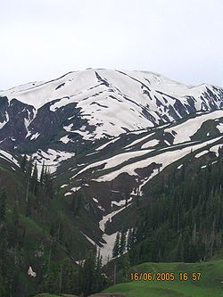
Because it lies immediately south of the main Himalaya Range, and is exposed to moist winds from the Arabian Sea
Arabian Sea
The Arabian Sea is a region of the Indian Ocean bounded on the east by India, on the north by Pakistan and Iran, on the west by the Arabian Peninsula, on the south, approximately, by a line between Cape Guardafui in northeastern Somalia and Kanyakumari in India...
, Hazara is the wettest part of Pakistan. At Abbottabad, annual rainfall averages around 1200 millimetres (47.2 in) but has been as high as 1800 millimetres (70.9 in) , whilst in parts of Mansehra District such as Balakot
Balakot
Balakot , is a town in Mansehra District in the Khyber-Pakhtunkhwa province of Pakistan. The town was destroyed during the 2005 earthquake and later rebuilt with the assistance of the Government of Pakistan and Saudi Public Assistance for Pakistan Earthquake Victims , a Saudi relief organization...
the mean annual rainfall is as high as 1750 millimetres (68.9 in) . Due to its location on the boundary between the monsoonal summer rainfall regime of East Asia
East Asia
East Asia or Eastern Asia is a subregion of Asia that can be defined in either geographical or cultural terms...
and the winter-dominant Mediterranean climate
Mediterranean climate
A Mediterranean climate is the climate typical of most of the lands in the Mediterranean Basin, and is a particular variety of subtropical climate...
of West Asia, Hazara has an unusual bimodal rainfall regime, with one peak in February or March associated with frontal southwest cloudbands and another monsoonal peak in July and August. The driest months are October to December, though in the wettest parts even these months average around 40 millimetres (1.6 in) .
Due to the high altitude, temperatures in Hazara are cooler than on the plains, though Abbottabad at 1200 metres (3,937 ft) still has maxima around 32°C (90°F) with high humidity in June and July. Further up, temperatures are cooler, often cooler than the Northern Areas
Northern Areas
Gilgit-Baltistan , is the northernmost political entity within Pakistan. It borders Pakistan's Khyber Pukhtunkhwa province to the west, Afghanistan's Wakhan Corridor to the north, China to the east and northeast, Azad Kashmir to the southwest, and Indian-administered Jammu and Kashmir to the...
valleys due to the cloudiness. In winter, temperatures are cold, with minima in January around 0°C (32°F) and much lower in the high mountains. Snowfalls are not uncommon even at lower levels.
Hazara lies close to the crossroads formed by the river Indus and the Grand Trunk Road
Grand Trunk Road
The Grand Trunk Road also formerly known as Uttarapatha, Shah Rah-e-Azam or Sadak-e-Azam or Badshahi Sadak is one of South Asia's oldest and longest major roads...
. The Karakoram Highway
Karakoram Highway
The Karakoram Highway is the highest paved international road in the world, but at its peak at the China-Pakistan border it is only paved on the Chinese side. It connects China and Pakistan across the Karakoram mountain range, through the Khunjerab Pass, at an altitude of as confirmed by both...
begins at the town of Havelian and goes north through the division towards China
China
Chinese civilization may refer to:* China for more general discussion of the country.* Chinese culture* Greater China, the transnational community of ethnic Chinese.* History of China* Sinosphere, the area historically affected by Chinese culture...
via the Northern Areas.
Population
The population of the Hazara region was estimated to be over 4.5 million in 2005. The total area of Hazara is 18013 km²: See table below.| District | Area (km²) | Population (Millions) |
| Abbottabad Abbottabad District Abbottabad is a district in the Khyber Pakhtunkhwa province of Pakistan. The district covers an area of 1,969 km with the city of Abbottabad being the principal town... |
1802 | 2 |
| Batagram Batagram District Battagram is a district of Hazara in the Khyber Pakhtunkhwa province of Pakistan. It has a total land area of 1301 square kilometres and the estimated population of Battagram District in 2004-2005 was 361,000. .-Etymology:Battagram in Sanskrit means Village of the Brahmins... |
1310 | 1.5 |
| Haripur Haripur District Haripur is a district in the Hazara region of Khyber-Pukhtunkhwa, province of Pakistan with an altitude of around above sea level. Haripur District has the highest Human Development Index of all the districts in the Hazara.... |
1763 | 1 |
| Kohistan | 7581 | 0.8 |
| Mansehra Mansehra District Mansehra District is in the Khyber Pakhtunkhwa province of Pakistan, an area still unofficially known as the Northwest Frontier. Mansehra district and town are named after Man Singh, a leading general of Mughal Emperor Akbar... |
5957 | 2.4 |
Demographics and society
Pashto language
Pashto , known as Afghani in Persian and Pathani in Punjabi , is the native language of the indigenous Pashtun people or Afghan people who are found primarily between an area south of the Amu Darya in Afghanistan and...
. Pashto is spoken in Batagram and Toorghar district, 70% of the population of Mansehra speaks Hindko while most of the remaining speak Pashto. Kohistani
Kohistani language
Kohistani is a Dardic language spoken in Kohistan District, Khyber Pakhtunkhwa Province, Pakistan. Dardic languages are a branch of the Indo-Iranian language group, which in turn is branch of the Indo-European language family...
are spoken in Kohistan
Kohistan
Kohistan, also transliterated Kuhistan, Kuhiston, Quhistan , may refer to:in Afghanistan*Kohistan, Kapisa Province, Kapisa Province, a town and administrative center of Hesa Awal Kohistan District...
. In all the hilly areas of Abbottabad and Haripur districts most people speak Hinkdo, but Gujjar
Gujjar
The Gurjar are an ethnic group in India, Pakistan and Afghanistan. Alternative spellings include Gurjara, Gujar, Gurjjara and Gūrjara. The spelling Gurjara or Gurjar is preferable to the rest....
tribes speaks Gojri
Gojri
Gojri, also known as Gujari is a variety of Rajasthani spoken by the Gujjars of Northern-Pakistan, India and Afghanistan.Rajasthani, Marwari and Gujarati are evolved from Gujari. The language was known as Gujjar bhakha or Gurjar Apabhramsha lately. It was used as literary language as early as 12th...
and Abbasi tribe speaks Phari(Dhondi Dialect ),Karlals of Galliyat also speak Phari language (Karlali Dialect) In all, according to the 2001 Census of Pakistan, Hazara has an ethno-linguistic majority of Hindko-speakers of around 60% whereas about 40% speak Pashto and other languages (Gojri,Phari etc.
Main tribes
The main tribes in terms of population in Hazara are the Gujjar, Malik, Tanoli, Karlal, Turk, Abbasi(Dhunds), Syed(Sadaat), Awan, Swati, Jadoon, Sulemani, Ghakkar(Rajpoots), Maddakhel ,Kohistanis, Tarin (or Tareen), Qureshi, Mishawani, Paracha, Mir, Mughals, Tahirkheli, Kashmiri, Dilazak, shilmani and the Isazai tribe of Kala Dhaka.Afghan refugees, although predominantly Pashtun (including the Ghilzai and Durrani tribes), and other smaller groups are found throughout Hazara Division
Hazara Division
On the dissolution of West Pakistan in 1970, Hazara District and the two tribal agencies were merged to form the new Hazara Division with its capital at Abbottabad...
. There is also a considerable presence of Tajiks, Uzbeks
Uzbeks
The Uzbeks are a Turkic ethnic group in Central Asia. They comprise the majority population of Uzbekistan, and large populations can also be found in Afghanistan, Tajikstan, Kyrgyzstan, Turkmenistan, Kazakhstan, Russia, Pakistan, Mongolia and the Xinjiang Uyghur Autonomous Region of China...
, Kazakh and Hazara in the area. Pakistan has provided shelter to them for more than three decades. However now intense popular demand exists for repatriation of all Afghan refugees from Hazara and Pakistan. It is hoped that the Govenemnt has extended their stay for a final time up to the end of 2012.
The population of Hazara was estimated to be over 4.5 million in 2005.
Economy
Hazara has one of the major industrial areas of NWFP, including Telephone Industry of Pakistan (TIP) and the HattarHattar
Hattar is one of the 44 union councils, administrative subdivions, of Haripur District in the Khyber Pakhtunkhwa province of Pakistan. It is located south of the district capital, Haripur, at 33°51'1N 72°51'8E and borders Taxila Tehsil of Punjab province....
Industrial Zone. The region includes Tarbela Dam
Tarbela Dam
Tarbela Dam on the Indus River in Pakistan is the second largest dam in the world by structural volume. It is located in Haripur District, Khyber Pakhtunkhwa, about northwest of Islamabad.The dam is high above the riverbed. The dam forms the Tarbela Reservoir, with a surface area of approximately...
, which is the largest earth filled dam in the world and generates most of the hydro electricity generated in Pakistan. The Karakoram Highway
Karakoram Highway
The Karakoram Highway is the highest paved international road in the world, but at its peak at the China-Pakistan border it is only paved on the Chinese side. It connects China and Pakistan across the Karakoram mountain range, through the Khunjerab Pass, at an altitude of as confirmed by both...
passes through Hazara.
The Pakistan Military Academy
Pakistan Military Academy
The Pakistan Military Academy is a four-year coeducational federal service military academy. It is located at Kakul near Abbottabad in Khyber-Pakhtunkhwa, Pakistan....
at Kakul
Kakul
Kakul is a town situated in the Kakul Valley at an elevation of 1300 metres, 5 km northeast of Abbottabad city near the Thandiani Hills, in Khyber-Pakhtunkhwa province of Pakistan. The population is around 30,000.-History:...
, Abbottabad, is where all military officers of Pakistan are trained. The region has tea plantations and the best grade tobacco in Pakistan, in Mansehra
Mansehra District
Mansehra District is in the Khyber Pakhtunkhwa province of Pakistan, an area still unofficially known as the Northwest Frontier. Mansehra district and town are named after Man Singh, a leading general of Mughal Emperor Akbar...
.
Movement for Hazara Province
Like the movement of Saraiki speaking people in Punjab, the people of Hazara also raised a voice of the same kind. This movement, founded in 1987, is named "Hazara Qaumi Mahaz" (HQM). The movement which has members across the country recently rose to prominence again with leaders again raising a demand for separate Hazara Province.In April 2010, it was announced that through an amendment in the Constitution of Pakistan, the name of NWFP would be changed to 'Khyber Pakhtunkhwa' leading to protests across the Hazara region, where Hindko
Hindko language
Hindko , also Hindku, or Hinko, is the sixth main regional language of Pakistan. It forms a subgroup of Indo-Aryan languages spoken by Hindkowans in Pakistan and northern India, some Pashtun tribes in Pakistan, as well as by the Hindki people of Afghanistan...
and Gojri
Gojri
Gojri, also known as Gujari is a variety of Rajasthani spoken by the Gujjars of Northern-Pakistan, India and Afghanistan.Rajasthani, Marwari and Gujarati are evolved from Gujari. The language was known as Gujjar bhakha or Gurjar Apabhramsha lately. It was used as literary language as early as 12th...
speakers are dominant as compared to the Pashto
Pashto language
Pashto , known as Afghani in Persian and Pathani in Punjabi , is the native language of the indigenous Pashtun people or Afghan people who are found primarily between an area south of the Amu Darya in Afghanistan and...
speakers. The announcement of the new name also led to calls from Hazara for a new separate province. Ten persons died, and nearly two hundred were hurt during the rallies and protest all over Hazara region against NWFP and creation of new province Hazara in April, 2010 and a complete wheel-jam and shutter-down strike was again observed in the Hazara on 2nd May, 2010,in support of this demand. Large public meetings in this regard as well as public protests have been regularly organised by the HQM and 'Tehreek I Hazara' movement, since; but the name of the NWF Province has been duly changed to 'Khyber Pakhtunkwha' and is a 'fait accompli'. The leadership of the Hazara movement, however, have vowed to continue their struggle until the achievement of their aims via peaceful and constitutional means.