

Black Mountain of Hazara
Encyclopedia
Pakistan
Pakistan , officially the Islamic Republic of Pakistan is a sovereign state in South Asia. It has a coastline along the Arabian Sea and the Gulf of Oman in the south and is bordered by Afghanistan and Iran in the west, India in the east and China in the far northeast. In the north, Tajikistan...
. Formerly a tribal area, it also became a settle area under Article 246 of the Constitution, when it official became a district on 28th January 2011.
Topography
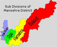
It lies between 34º32' and 34º50' N, and 72º48' and 72º58' E. It is bounded on the east by AgrorAgror
The Agror valley is located in Mansehra District, Hazara in the Khyber-Pakhtunkhwa province of Pakistan. It consists of three mountain glens, in length and in breadth, located between and .- Environment :...
and on the south by Tanawal; to the west it is bounded by Buner
Buner
Chinglai Buner may refer to:* Buner Valley in Pakistan.* Buner District in Pakistan....
, to the northeast it borders with Batagram
Batagram
Battagram is the capital city of Battagram District in Khyber Pukhtoonkhwa Province of Pakistan. It is located at 34°41'N 73°1'E and has an altitude of 1038 metres .-Administration:...
. The range has a length of 25 to 30 miles from north to south and an elevation of 8,000 feet above sea level. This area has also been called Chagharzai, because of adjoining Chagharzai areas of Buner District. Opposite Kala Dhaka (officially 'Kala Dhaka' has been renamed 'Tor Ghar'), across the River Indus is Shangla District
Shangla District
Shangla District ' is located in the Khyber-Pakhtunkhwa province of Pakistan.The district headquarters are located at Alpuri. It was previously a subdivision of Swat District, but was upgraded to the status of a district on July 10, 1995 by the then Chief Minister Aftab Khan Sherpao. The total...
, mainly the area belonging to Tehsil Martung
Martung
Martung , Mārtung or Martoong is a highland village and sub tehsil of Shangla District, Khyber Pakhtunkhwa , Pakistan included in Puran Subdivision. Central Martung is 982 meters above sea level., Being not plain area, some parts of Martung are even more than 1800 meters above mean sea level...
.
The Indus washes its northern extremity and then turns due south. Between the river and the crest of the range the western slopes are occupied by Yusufzai Pakhtoons. The rest of the range is held by Swatis tribal group of Pakhtoons. The Black Mountain forms a long, narrow ridge, with higher peaks at intervals and occasional deep passes. The highest peak is known as "Machay Sar" and is visible from Agror and other adjoining areas. Numerous spurs project from its sides, forming narrow gorges in which lie the villages of the tribes. The upper parts of the ridge and spurs are covered with thick forests of pine, oak, sycamore, horse-chestnut, and wild cherry; but the slopes are stony and barren.
Administration
Tor Ghar is a district of Khyber Pakhtoonkhwa. It cover an area of 497 km2 (25,8125 acres) and is divided into 11 Union CouncilsUnion Councils of Pakistan
A sherwan or village council in Pakistan is an elected local government body consisting of 21 councillors, and headed by a nazim and a naib nazim...
.
History
The Tor Ghar (Black Mountain) massif was a series of spurs running up to a central, dominating ridge line, which reached 9817 feet at its highest peak, the peak of Machai Sar. Along this ridge ran the line beyond which the British writ did not run, though the local tribes lived on both sides regardless. The area was not on road to anywhere and the British had been happy to let it be; unfortunately the inhabitants were not inclined to let them do so. These were unusually mixed group of tribes, not particularly large or powerful, but warlike, and in some cases, religiously motivated against the British. Politically, they were nominally under the influence of two independent princelings, the Nawab of AmbAMB
Amb may refer to:* Amb , a town in the Azad Kashmir, Pakistan* Amb, India, a town Himachal Pradesh, India* Amb , a region in the former Indian Empire* Amb special form, a nondeterministic programming construct using continuations...
and the Wali of Swat, but these exercised little real power in the hills. On the eastern mountain, nearest British territory, lived the Swatis.
The British
United Kingdom
The United Kingdom of Great Britain and Northern IrelandIn the United Kingdom and Dependencies, other languages have been officially recognised as legitimate autochthonous languages under the European Charter for Regional or Minority Languages...
sent more than four expeditions to subdue the Black Mountain tribes between 1852 and 1892 because Ata Mohammad Khan Swati, the Khan of Agror
Agror
The Agror valley is located in Mansehra District, Hazara in the Khyber-Pakhtunkhwa province of Pakistan. It consists of three mountain glens, in length and in breadth, located between and .- Environment :...
and Arsala Khan of Allai
Allai
Allai is an administrative subdivision of Batagram District in the Khyber-Pakhtunkhwa province of Pakistan - that also contains the Allai Valley.- History :...
, and his sons intrigued against the British government
British Empire
The British Empire comprised the dominions, colonies, protectorates, mandates and other territories ruled or administered by the United Kingdom. It originated with the overseas colonies and trading posts established by England in the late 16th and early 17th centuries. At its height, it was the...
.
In 1851 two officers of the British Customs (Salt) department within the borders of Tanawal were killed, allegedly by the Hasanzai sect of the Yusufzai. The British then sent an expedition under Colonel Mackeson, which destroyed a number of tribal strongholds. In 1868 the Yusufzai, instigated by the Khan of Agror, who resented the establishment of the police post at Oghi in the Agror valley, attacked that post in force, but were repulsed. Further attacks on the troops of the Khan of Tanawal, who remained loyal, followed. This culminated in a general advance of the Black Mountain tribes against the British position. It was repulsed, but not until 21 British villages had been burnt, and a second expedition under General Wilde had overrun the Black Mountain and secured the full submission of the tribes.
"The Black Mountain adjoins the territory of the Wali of Swat. It is so called from the dark forests of that cover its slopes. The eastern sides are held by the original people of Swat. They are not Pathans at all. The western ridge is the homeland of Yousafzai tribes. The Black Mountain tribes are less warlike and weak in number. There is constant struggle among small tribal chiefs. The most important of these is the Nawab of Amb
AMB
Amb may refer to:* Amb , a town in the Azad Kashmir, Pakistan* Amb, India, a town Himachal Pradesh, India* Amb , a region in the former Indian Empire* Amb special form, a nondeterministic programming construct using continuations...
. He enjoys the unique distinction of being an independent chief across the Indus. The Nawab of Amb has an arms factory. He manufactures rifled cannon. This cannon can throw a solid ball 3000 yards. It is a useful weapon for pounding to pieces a tribal fortress."
In 1888 the British blockaded the area due to the raids by the Hasanzai and Akazai aided by the Madda Khel into the Agror valley. While more stringent measures were being organized, Major Battye and Captain Urmston and some sepoys of the Fifth Gurkhas were surprised and killed by Gujar dependents of the Akazai. Hashim Ali, the head of the Hasanzai and Akazai, was suspected of having instigated the attack. An expedition was sent in the same year, with the result that the tribes paid the fines imposed upon them, and agreed to the removal of Hashim Ali from Tor Ghar and the appointment in his place of his near relative and enemy Ibrahim Khan (Hasanzai Tribe Elder). In 1890 the tribe opposed the march of troops along the crest of the Black Mountain, and an expedition was sent against them in the spring of 1891. Immediately after the withdrawal of the troops, the Hindustanis and Madda Khel broke their agreement with the British Government by permitting the return of Hashim Ali Hasanzai. A second expedition was dispatched in 1892 which resulted in the complete pacification of the Black Mountain border.
Earthquake 2005
Tor Ghar was badly affected by the 2005 Pakistan earthquake, according to a report in Time magazine:Regions that remain inaccessible have one thing in common: fear of the unknown can create legends and stereotypes that spread. Tor Ghar has not been immune to this. For example, the highway was diverted around this region because engineers were unwilling to be put in rifle range of these tribesmen. A British journalist who went to the region reported its recent history:
Here are the impressions of an outsider about Tor Ghar who happened to visit the area as a member of relief organisation after October 8, 2005 earthquake.
Geography
The Black Mountain itself has a total length of 20 to 25 miles, and an average height of 8,000 ft. It rises from the Indus basin near the village of Kiara up to its watershed by Bruddur, then it runs northwest by north to the point on the crest known as Chittabut. From Chittabut the range runs due north, finally descending by two large spurs to the Indus again.The only road that traverses Tor Ghar from Darband to Thakot is 84 kilometres Long. This road connects the area with the outer world.
Thakot is on the Karakoram Highway
Karakoram Highway
The Karakoram Highway is the highest paved international road in the world, but at its peak at the China-Pakistan border it is only paved on the Chinese side. It connects China and Pakistan across the Karakoram mountain range, through the Khunjerab Pass, at an altitude of as confirmed by both...
and thus coming out of Kaladhaka Via Thakot is a much better route as compared to choosing the Darband Route. The Karakoram Highway is in a much better shape from Thakot down to Abbottabad
Abbottabad
Abbottabad is a city located in the Hazara region of the Khyber Pakhtunkhwa province, in Pakistan. The city is situated in the Orash Valley, northeast of the capital Islamabad and east of Peshawar at an altitude of and is the capital of the Abbottabad District...
. The road that traverses through Tor Ghar keeps in touch with the left bank of the River Indus almost throughout its course.
Tor Ghar is also called F. R. Mansehra. F. R. denotes Frontier Region. This tribal area is administered by Administrator Tor Ghar on the behalf of Provincial Govt. who is based at Mansehra. There is also a political agent/political tehsildar
Tehsildar
A tehsildar is a revenue administrative officer in Pakistan and India in charge of obtaining taxation from a tehsil. The term is of imperial Mughal origin made of "tahsil", an Islamic administrative derived from Arabic, meaning "revenue generating; collection" and "dar", Persian for "holder of a...
who is usually based at Oghi Town (Ogai).
Roads
- Darband To Thakot Road.
- Khanano Dheri (Buner District) to Manjakot (not completed yet)
- Petao Amazai (Distt: Shangla) To Mada Khel (not completed yet)
- Shugli Bandi Oghi To Tilli Saydan Hasanzai
- Oghi Choor Kalam To Machai Sar
- Gijborri (Batagram District) To Mangri & Kamasir
- Kotgala (Batagram District) to Bartooni
- Topi (District Swabi) to Teetay Madakhail (the best way to travel to Tor Ghar)
- Dilbori to Miran and Beland Kot to Sonchal
Tribes
On the western slopes most people in Tor Ghar (Black Mountain) are Pukhtoons from Mada Khel, Hasanzai, Akazai, Nusrat Khel and Basi Khel the divisions of Isazai and Malizai sub-clans of the Yousufzai tribe, while eastern slopes are dominated by the Swati clans, some Hindko speaking people can be found at the fringes of the region.The Black Mountain (Tor Ghar) Tribes
The Black Mountain (Tor Ghar) Tribes
The original name of the Black Mountain is Tor Ghar, which is a Pushto word which means Tor Ghar . Tor Ghar is situated in Hazara division of the Khyber Pakhtunkhwa province of Pakistan. Tor Ghar is lying to the east of the Indus river from Thakot to Darband...
have a more certain origin among the people of Mansehra district. They belong to the Isazai and Malazai clans of the Yousafzai tribe. The Isazai sub-clan is further divided into three sub-clans: Mada Khel, Hassanzai and Akazai. The Malazai sub-clan is divided into two sub-clans: Basi Khel and Nasrat Khel. Basikhel is the largest group, consisting of 37% of the population of Tor Ghar while Nusrat Khel and Akazai constitute 12% each; the populations of Hasanzai and Mada Khel are 18.5% and 20% respectively. Basi Khel, Nusrat Khel and Akazai inhabit the left bank of the Indus while the Mada Khel tribe resides on the right side and the Hassanzai
Hassanzai
The Hassanzai is a Pakhtoon/Pashtoon/Pathan tribe. It is one of the division of Isazai clan of the Yousafzai tribe which is one of the most powerful, famous and respected tribe of Pashtoons...
are situated on both the sides of river Indus.
Population
| Tribes | Population (thousands) |
| Mada Khel Mada Khel The Mada Khel is a Pakhtoon/Pashtoon/Pathan tribe. It is one of the division of Isazai clan of the Yousafzai tribe which is one of the most powerful, famous and respected tribe of Pashtoons... |
approximately 24,000 |
| Hassanzai Hassanzai The Hassanzai is a Pakhtoon/Pashtoon/Pathan tribe. It is one of the division of Isazai clan of the Yousafzai tribe which is one of the most powerful, famous and respected tribe of Pashtoons... |
approximately 35,000 |
| Akazai Akazai The Akazai is a Pakhtoon/Pashtoon/Pathan tribe. It is one of the division of Isazai clan of the Yousafzai tribe which is one of the most powerful, famous and respected tribe of Pashtoons. Colonel Wylly, Harold Carmichael, 1858–1932, has described these great people in just one sentence; laeving no... |
approximately 35,000 |
| Nusrat Khel | approximately 12,000 |
| Basi Khel | approximately 85,000 |
Total population of five major tribes = 185,000