
Tarbela Dam
Encyclopedia
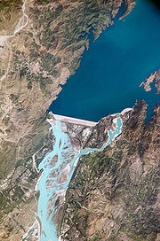
Tarbela Dam on the Indus River
in Pakistan
is the second largest dam in the world by structural volume. It is located in Haripur District
, Khyber Pakhtunkhwa, about 50 kilometres (31.1 mi) northwest of Islamabad
.The dam is 485 feet (147.8 m) high above the riverbed. The dam forms the Tarbela Reservoir, with a surface area of approximately 250 square kilometres (96.5 sq mi). The dam was completed in 1974 and was designed to store water from the Indus River for irrigation
, flood control
, and the generation of hydroelectric power
.
s, located on the auxiliary dams, in turn consist of two parts. The main spillway has a discharge capacity of 18406 m3/s and the auxiliary spillway, 24070 m3/s. The outlet works
are a group of four tunnels that have been cut through the valley wall at river right, for uses of hydropower generation and flow control. These tunnels were originally used to divert the Indus River while the dam was being constructed.
A hydroelectric power plant on the right side of the main dam houses 14 generators fed with water from outlet tunnels 1, 2, and 3. There are four 175 MW generators on tunnel 1, six 175 MW generators on tunnel 2, and four 432 MW generators on tunnel 3, for a total generating capacity of 3,478 MW. Tarbela Reservoir is 80.5 kilometres (50 mi) long, with a surface area of 250 square kilometres (96.5 sq mi). The reservoir holds 11600000 acre.ft of water, with a live storage of 9700000 acre.ft. The catchment area upriver of the Tarbela Dam is spread over 168000 square kilometres (64,865.2 sq mi) of land largely supplemented by snow and glacier melt from the southern slopes of the Himalayas
. There are two main Indus River tributaries upstream of the Tarbela Dam. These are the Shyok River
, joining near Skardu
, and the Siran River near Tarbela
.
The Tarbela Dam is the second largest in terms of dam volume in the world.
Many affectees of the Tarbela Dam have still not been settled and not been given land as compensataion by the Government of Pakistan, accordance with its contractual obligations with World Bank.
, the river carries huge amounts of sediment
. The annual suspended sediment load is about 430 million tons. This means that, over time, the reservoir will fill. The useful life of the dam and reservoir was estimated to be somewhere around fifty years, since the dam's completion in 1976, meaning that the reservoir would have been full of sediment by 2030.
However, sedimentation has been much lower than predicted, and it is now estimated that the useful lifespan of the dam will be 85 years, to about 2060.
Indus River
The Indus River is a major river which flows through Pakistan. It also has courses through China and India.Originating in the Tibetan plateau of western China in the vicinity of Lake Mansarovar in Tibet Autonomous Region, the river runs a course through the Ladakh district of Jammu and Kashmir and...
in Pakistan
Pakistan
Pakistan , officially the Islamic Republic of Pakistan is a sovereign state in South Asia. It has a coastline along the Arabian Sea and the Gulf of Oman in the south and is bordered by Afghanistan and Iran in the west, India in the east and China in the far northeast. In the north, Tajikistan...
is the second largest dam in the world by structural volume. It is located in Haripur District
Haripur District
Haripur is a district in the Hazara region of Khyber-Pukhtunkhwa, province of Pakistan with an altitude of around above sea level. Haripur District has the highest Human Development Index of all the districts in the Hazara....
, Khyber Pakhtunkhwa, about 50 kilometres (31.1 mi) northwest of Islamabad
Islamabad
Islamabad is the capital of Pakistan and the tenth largest city in the country. Located within the Islamabad Capital Territory , the population of the city has grown from 100,000 in 1951 to 1.7 million in 2011...
.The dam is 485 feet (147.8 m) high above the riverbed. The dam forms the Tarbela Reservoir, with a surface area of approximately 250 square kilometres (96.5 sq mi). The dam was completed in 1974 and was designed to store water from the Indus River for irrigation
Irrigation
Irrigation may be defined as the science of artificial application of water to the land or soil. It is used to assist in the growing of agricultural crops, maintenance of landscapes, and revegetation of disturbed soils in dry areas and during periods of inadequate rainfall...
, flood control
Flood control
In communications, flood control is a feature of many communication protocols designed to prevent overwhelming of a destination receiver. Such controls can be implemented either in software or in hardware, and will often request that the message be resent after the receiver has finished...
, and the generation of hydroelectric power
Hydroelectricity
Hydroelectricity is the term referring to electricity generated by hydropower; the production of electrical power through the use of the gravitational force of falling or flowing water. It is the most widely used form of renewable energy...
.
Description
The project is located at a narrow spot in the Indus River valley, at Tarbela in Haripur, shortly located at the point from where the District Swabi starts. Here the river formerly split around a large island close to the left bank. The main dam wall, built of earth and rock fill, stretches 2743 metres (8,999.3 ft) from the island to river right, standing 148 metres (485.6 ft) high. A pair of concrete auxiliary dams spans the river from the island to river left. The spillwaySpillway
A spillway is a structure used to provide the controlled release of flows from a dam or levee into a downstream area, typically being the river that was dammed. In the UK they may be known as overflow channels. Spillways release floods so that the water does not overtop and damage or even destroy...
s, located on the auxiliary dams, in turn consist of two parts. The main spillway has a discharge capacity of 18406 m3/s and the auxiliary spillway, 24070 m3/s. The outlet works
Outlet works
A set of outlet works is a device used to release and regulate water flow from a dam. Such devices usually consist of one or more pipes or tunnels through the embankment of the dam, directing water usually under high pressure to the river downstream...
are a group of four tunnels that have been cut through the valley wall at river right, for uses of hydropower generation and flow control. These tunnels were originally used to divert the Indus River while the dam was being constructed.
A hydroelectric power plant on the right side of the main dam houses 14 generators fed with water from outlet tunnels 1, 2, and 3. There are four 175 MW generators on tunnel 1, six 175 MW generators on tunnel 2, and four 432 MW generators on tunnel 3, for a total generating capacity of 3,478 MW. Tarbela Reservoir is 80.5 kilometres (50 mi) long, with a surface area of 250 square kilometres (96.5 sq mi). The reservoir holds 11600000 acre.ft of water, with a live storage of 9700000 acre.ft. The catchment area upriver of the Tarbela Dam is spread over 168000 square kilometres (64,865.2 sq mi) of land largely supplemented by snow and glacier melt from the southern slopes of the Himalayas
Himalayas
The Himalaya Range or Himalaya Mountains Sanskrit: Devanagari: हिमालय, literally "abode of snow"), usually called the Himalayas or Himalaya for short, is a mountain range in Asia, separating the Indian subcontinent from the Tibetan Plateau...
. There are two main Indus River tributaries upstream of the Tarbela Dam. These are the Shyok River
Shyok River
The Shyok River flows through northern Ladakh in India and the Northern Areas of Pakistan , spanning some .The Shyok River, a tributary of the Indus River, originates from the Rimo Glacier, one of the tongues of Siachen Glacier. The river widens at the confluence with the Nubra River...
, joining near Skardu
Skardu
Skardu , is the main town of the region Baltistan and the capital of Skardu District, one of the districts making up Pakistan's Gilgit Baltistan....
, and the Siran River near Tarbela
Tarbela
Tarbela is one of the 44 union councils, administrative subdivision, of Haripur District in the Khyber Pakhtunkhwa province of Pakistan....
.
The Tarbela Dam is the second largest in terms of dam volume in the world.
Settlement of Tarbela Dam affectees
It has a reservoir area of about 260 square kilometers and about 82,000 acres land was acquired for its construction. The large reservoir of the dam submerged 135 villages, which resulted in displacement of a population of about 96,000 people. For the land and built-up property acquired under the Land Acquisition Act of 1984, a cash compensation of Rs 469.65 million was paid to the affectees. In the absence of a national policy, resettlement concerns of the affectees of Tarbela Dam were addressed on ad hoc basis.Many affectees of the Tarbela Dam have still not been settled and not been given land as compensataion by the Government of Pakistan, accordance with its contractual obligations with World Bank.
Life Span
Because the source of the Indus River is glacial meltwater from the HimalayasHimalayas
The Himalaya Range or Himalaya Mountains Sanskrit: Devanagari: हिमालय, literally "abode of snow"), usually called the Himalayas or Himalaya for short, is a mountain range in Asia, separating the Indian subcontinent from the Tibetan Plateau...
, the river carries huge amounts of sediment
Sedimentation
Sedimentation is the tendency for particles in suspension to settle out of the fluid in which they are entrained, and come to rest against a barrier. This is due to their motion through the fluid in response to the forces acting on them: these forces can be due to gravity, centrifugal acceleration...
. The annual suspended sediment load is about 430 million tons. This means that, over time, the reservoir will fill. The useful life of the dam and reservoir was estimated to be somewhere around fifty years, since the dam's completion in 1976, meaning that the reservoir would have been full of sediment by 2030.
However, sedimentation has been much lower than predicted, and it is now estimated that the useful lifespan of the dam will be 85 years, to about 2060.