
Hampshire County, West Virginia
Encyclopedia
Hampshire County is a county located in the U.S. state
of West Virginia
. As of 2010, the population
was 23,964. Its county seat
is Romney
, West Virginia's oldest town
(1762). Hampshire County was created by the Virginia General Assembly
on December 13, 1753, from parts of Frederick
and Augusta
counties (Virginia
) and is the oldest county in the state of West Virginia. The county lies in both West Virginia's Eastern Panhandle and Potomac Highlands regions. Hampshire County is part of the Winchester, VA-WV Metropolitan Statistical Area (MSA)
.
 Although its creation was authorized in 1753, Hampshire County was not actually organized until 1757 because the area was not considered safe due to the outbreak of the French and Indian War
(1754–1763). According to Samuel Kercheval's A History of the Valley of Virginia (1833), the county was named in honor of its several prize hogs. The story goes that Thomas Fairfax, 6th Lord Fairfax of Cameron
(1693-1781), who owned the Royal Grant to the area, came upon some very large hogs in Winchester
and asked where they had been raised. He was told that they were from the South Branch Potomac River Valley (now Hampshire County). He remarked that when a county was formed west of Frederick
that he would name it in honor of the county Hampshire
, England
, famous for its very fat hogs.
 According to the U.S. Census Bureau
, the county has a total area of 645 square miles (1,670.5 km²), of which 642 square miles (1,662.8 km²) is land and 3 square miles (7.8 km²) (0.45%) is water.
>
Year
Population
1900
11,806
1910
11,694
1920
11,713
1930
11,836
1940
12,974
1950
12,577
1960
11,705
1970
11,710
1980
14,867
1990
16,498
2000
20,203
2010
23,964
As of the census
of 2000, there were 20,203 people, 7,955 households, and 5,640 families residing in the county. The population density
was 32 people per square mile (12/km²). There were 11,185 housing units at an average density of 17 per square mile (7/km²). The racial makeup of the county was 98.04% White
, 0.83% Black
or African American
, 0.24% Native American
, 0.16% Asian
, 0.02% Pacific Islander
, 0.12% from other races
, and 0.59% from two or more races. 0.55% of the population were Hispanic
or Latino
of any race.
There were 7,955 households out of which 31.30% had children under the age of 18 living with them, 56.70% were married couples
living together, 9.50% had a female householder with no husband present, and 29.10% were non-families. 24.60% of all households were made up of individuals and 10.60% had someone living alone who was 65 years of age or older. The average household size was 2.49 and the average family size was 2.94.
In the county, the population was spread out with 25.10% under the age of 18, 7.10% from 18 to 24, 27.60% from 25 to 44, 25.60% from 45 to 64, and 14.60% who were 65 years of age or older. The median age was 38 years. For every 100 females there were 99.70 males. For every 100 females age 18 and over, there were 97.30 males.
The median income for a household in the county was $31,666, and the median income for a family was $37,616. Males had a median income of $28,884 versus $19,945 for females. The per capita income
for the county was $14,851. About 12.90% of families and 16.30% of the population were below the poverty line, including 22.70% of those under age 18 and 13.10% of those age 65 or over.
was initially settled by hunters and traders around 1725. In 1738, John Pearsall (or Pearsoll) and his brother Job built homes and in 1758 a fort (Fort Pearsall
) for defense against Native Americans
in present-day Romney. Their settlement was then known as Pearsall's Flats. In 1748, Thomas Fairfax, 6th Lord Fairfax of Cameron
sent a surveying party, including 16 year-old George Washington
, to survey his lands along the Potomac
and South Branch Potomac river
s. Washington spent three summers and falls surveying Lord Fairfax's Northern Neck
estate, which included all of the present-day Eastern Panhandle of West Virginia
. In April 1748, he laid off several lots in an area known as the Trough
, about ten miles (16 km) south of Romney, and he is known to have been in present-day Romney on October 19, 1749. Oral traditions claimed that Washington laid present-day Romney out into lots at that time, but written records from that era indicate that Romney was surveyed and laid out into lots by James Genn
prior to Washington's arrival. Genn was also employed by Lord Fairfax.
was constructed on Job Pearsall's plantation for protection against Native American
raids and George Washington provisioned and garrisoned the Fort at various times until 1758. At that time, there were at least 100 people living in the general area. Following the end of hostilities in the area, Lord Fairfax recognized that more settlers would be interested in moving into the area and that he could earn some extra revenue by selling plots in the town. He sent a survey party to Romney in 1762 to formally lay out the town into 100 lots. At that time, he renamed the town Romney, in honor of the Cinque Ports
city on the English Channel
in Kent
.
Confusion ensued for several decades concerning land ownership within the town as counterclaims were made by the original settlers and those who purchased lots laid out by Lord Fairfax's surveyors.
The first meeting of the Hampshire County Court was held in 1757, at Fort Pleasant
, now Old Fields
in Hardy County, and was presided by the Right Honorable Thomas Bryan Martin
, Lord Fairfax's nephew. By that time, Hampshire County's population had fallen dramatically as most of the settlers had fled the county in fear of the Native Americans. The only families remaining lived near Fort Pearsall, near present-day Romney, and Fort Edwards
, at present-day Capon Bridge
on the Cacapon River
. The vast majority of the remaining settlers, however, were in the vicinity of present Old Fields-Moorefield-Petersburg and were protected by the several forts in the area, including Fort Pleasant
Once the Native Americans were defeated at the Battle of Point Pleasant
in 1774 settlers, once again, returned to the county. By 1790, when the first national census was taken, Hampshire County had 7,346 residents, making it the second most populous county in the present state of West Virginia at that time. Berkeley
was the most populous county, with 19,713 people. There were nine counties that comprised the present state, with a total population of 55,873 people.
During the Whiskey Rebellion
in 1794, many Hampshire County men volunteered to serve under Major General Daniel Morgan
to put down the insurrection. The men most likely volunteered at Moorefield
in Hardy County
and then marched north to Cumberland, Maryland
. Approximately 1,200 of the 12,950 men under Morgan's command came from the area that would later become West Virginia.
missionaries among a group of settlers moved to the Cacapon
and organized the first European church in the county. In 1771 the work of the Methodist Episcopal Church
was begun, in which later developments led to the formation of the Methodist Episcopal Church, South
. In 1753 Hampshire County had been formed into a parish by the Protestant Episcopal Church and in 1773 a missionary sent by that church began work. In 1787 a Primitive Baptist
church was established at North River. Soon after the American Revolution
there was preaching by the Presbyterians at different points in the county. In 1792 a Presbyterian church was organized at Romney and another, Mount Bethel Church
, at Three Churches
.
, and fields of wheat
and tobacco
surrounded the important truck-patch of the settler. The rolling uplands offered pasturage for horses, cattle, sheep, and hogs, which were driven across country to market at Winchester
. The streams abounded in fish and the mountains contained not only game but timber and stone for early settlers' homes. The limestone was burned for lime at Bloomery Gap, where remains of old lime-kilns give evidence of an early industry. Soon it was discovered that some of the strata contained iron ore. Much of it was transported to present-day Keyser
, from an area along South Branch Potomac River south of the present limits of the county. In Bloomery Gap, a ruined furnace still stands, mute evidence of another former industry. In the early days the increasing population stimulated not only farming and grazing but every industry of a new country.Hampshire County was also known for its many gunmakers,located on or near the main road from Winchester to Romney.Among them were,Henry Topper,Jacob Kline,George Young, Benjamin Shane,George Glaze,William Britton and the Sheetz Family.
 The building of the Northwestern Turnpike
(U.S. Route 50
) was an integral part of the development of Hampshire County. General Daniel Morgan first suggested the road be built in 1748, but his recommendations were not acted upon until the 1830s. Colonel Claudius Crozet
, a Frenchman who had previously worked for Napoleon Bonaparte, engineered the road which connected Parkersburg
with Winchester, Virginia. The turnpike traversed Hampshire County stretching through the communities of Capon Bridge, Loom
, Hanging Rock
, Pleasant Dale
, Augusta
, Frenchburg
, Shanks
, and Romney
. Through the years, Romney became an important rest stop for travelers on the turnpike. This aided the local economy as hotels and taverns began to appear in the area.
During the American Civil War
, the Hampshire Guards and Frontier Riflemen joined the Confederate Army
. Although there were no major battles in Hampshire County, Romney changed hands at least fifty-six times during the war. It was often a case of one army evacuating the area allowing the opposing army to move into the town. This places Romney second behind Winchester as the town that changed hands the most during the American Civil War. On June 11, 1861, it changed hands twice in the same day. Some local Hampshire County historians speculate that Romney actually changed hands more than Winchester but there are no surviving records to support the claim.
U.S. state
A U.S. state is any one of the 50 federated states of the United States of America that share sovereignty with the federal government. Because of this shared sovereignty, an American is a citizen both of the federal entity and of his or her state of domicile. Four states use the official title of...
of West Virginia
West Virginia
West Virginia is a state in the Appalachian and Southeastern regions of the United States, bordered by Virginia to the southeast, Kentucky to the southwest, Ohio to the northwest, Pennsylvania to the northeast and Maryland to the east...
. As of 2010, the population
Population
A population is all the organisms that both belong to the same group or species and live in the same geographical area. The area that is used to define a sexual population is such that inter-breeding is possible between any pair within the area and more probable than cross-breeding with individuals...
was 23,964. Its county seat
County seat
A county seat is an administrative center, or seat of government, for a county or civil parish. The term is primarily used in the United States....
is Romney
Romney, West Virginia
Romney is a city in and the county seat of Hampshire County, West Virginia, United States. The population was 1,940 at the 2000 census, while the area covered by the city's ZIP code had a population of 5,873. It is a city with a very historic background dating back to the 18th century...
, West Virginia's oldest town
West Virginia's oldest town
There has been a long-running dispute over which town in West Virginia is the oldest. The dispute between Shepherdstown and Romney goes back well before West Virginia even became a state....
(1762). Hampshire County was created by the Virginia General Assembly
Virginia General Assembly
The Virginia General Assembly is the legislative body of the Commonwealth of Virginia, and the oldest legislative body in the Western Hemisphere, established on July 30, 1619. The General Assembly is a bicameral body consisting of a lower house, the Virginia House of Delegates, with 100 members,...
on December 13, 1753, from parts of Frederick
Frederick County, Virginia
Frederick County is a county located in the Commonwealth of Virginia. It is included in the Winchester, Virginia-West Virginia Metropolitan Statistical Area. It was formed in 1743 by the splitting of Orange County. For ten years it was the home of George Washington. As of 2010, the population was...
and Augusta
Augusta County, Virginia
As of the census of 2000, there were 65,615 people, 24,818 households, and 18,911 families residing in the county. The population density was 68 people per square mile . There were 26,738 housing units at an average density of 28 per square mile...
counties (Virginia
Virginia
The Commonwealth of Virginia , is a U.S. state on the Atlantic Coast of the Southern United States. Virginia is nicknamed the "Old Dominion" and sometimes the "Mother of Presidents" after the eight U.S. presidents born there...
) and is the oldest county in the state of West Virginia. The county lies in both West Virginia's Eastern Panhandle and Potomac Highlands regions. Hampshire County is part of the Winchester, VA-WV Metropolitan Statistical Area (MSA)
Winchester, VA-WV MSA
Winchester, VA-WV MSA is a U.S. Metropolitan Statistical Area as defined by the United States Office of Management and Budget as of June, 2003. Its population as of 2008 U.S. Census Bureau estimates is 122,369....
.
Name
French and Indian War
The French and Indian War is the common American name for the war between Great Britain and France in North America from 1754 to 1763. In 1756, the war erupted into the world-wide conflict known as the Seven Years' War and thus came to be regarded as the North American theater of that war...
(1754–1763). According to Samuel Kercheval's A History of the Valley of Virginia (1833), the county was named in honor of its several prize hogs. The story goes that Thomas Fairfax, 6th Lord Fairfax of Cameron
Thomas Fairfax, 6th Lord Fairfax of Cameron
Thomas Fairfax, 6th Lord Fairfax of Cameron was the son of Thomas Fairfax, 5th Lord Fairfax of Cameron and of Catherine, daughter of Thomas Culpeper, 2nd Baron Culpeper of Thoresway....
(1693-1781), who owned the Royal Grant to the area, came upon some very large hogs in Winchester
Winchester, Virginia
Winchester is an independent city located in the northwestern portion of the Commonwealth of Virginia in the USA. The city's population was 26,203 according to the 2010 Census...
and asked where they had been raised. He was told that they were from the South Branch Potomac River Valley (now Hampshire County). He remarked that when a county was formed west of Frederick
Frederick County, Virginia
Frederick County is a county located in the Commonwealth of Virginia. It is included in the Winchester, Virginia-West Virginia Metropolitan Statistical Area. It was formed in 1743 by the splitting of Orange County. For ten years it was the home of George Washington. As of 2010, the population was...
that he would name it in honor of the county Hampshire
Hampshire
Hampshire is a county on the southern coast of England in the United Kingdom. The county town of Hampshire is Winchester, a historic cathedral city that was once the capital of England. Hampshire is notable for housing the original birthplaces of the Royal Navy, British Army, and Royal Air Force...
, England
England
England is a country that is part of the United Kingdom. It shares land borders with Scotland to the north and Wales to the west; the Irish Sea is to the north west, the Celtic Sea to the south west, with the North Sea to the east and the English Channel to the south separating it from continental...
, famous for its very fat hogs.
Geography
United States Census Bureau
The United States Census Bureau is the government agency that is responsible for the United States Census. It also gathers other national demographic and economic data...
, the county has a total area of 645 square miles (1,670.5 km²), of which 642 square miles (1,662.8 km²) is land and 3 square miles (7.8 km²) (0.45%) is water.
Major highways
|
 West Virginia Route 29 West Virginia Route 29 West Virginia Route 127 West Virginia Route 127 West Virginia Route 259 West Virginia Route 259 |
 U.S. Highway 50
 U.S. Highway 220
 West Virginia Route 9
 West Virginia Route 28
Adjacent counties
- Allegany County, MarylandAllegany County, MarylandAllegany County is a county located in the northwestern part of the US state of Maryland. It is part of the Cumberland, MD-WV Metropolitan Statistical Area. As of 2010, the population was 75,087. Its county seat is Cumberland...
(north) - Morgan CountyMorgan County, West VirginiaMorgan County is a county located in the U.S. state of West Virginia. As of 2010, it's population was 17,541. Its county seat is Berkeley Springs. The county is one of three in Hagerstown-Martinsburg, MD-WV Metropolitan Statistical Area...
(northeast) - Frederick County, VirginiaFrederick County, VirginiaFrederick County is a county located in the Commonwealth of Virginia. It is included in the Winchester, Virginia-West Virginia Metropolitan Statistical Area. It was formed in 1743 by the splitting of Orange County. For ten years it was the home of George Washington. As of 2010, the population was...
(east) - Hardy CountyHardy County, West VirginiaAs of the census of 2000, there were 12,669 people, 5,204 households, and 3,564 families residing in the county. The population density was 22 people per square mile . There were 7,115 housing units at an average density of 12 per square mile...
(south) - Mineral CountyMineral County, West VirginiaMineral County is a county located in the U.S. state of West Virginia. It is part of the Cumberland, MD-WV Metropolitan Statistical Area. As of 2010, the population was 28,212. Its county seat is Keyser.-Ancient history:...
(west)
Magisterial districts
- Bloomery Magisterial District
- Capon Bridge municipality
- Capon Magisterial District
- Gore Magisterial District
- Mill Creek Magisterial District
- Romney Magisterial District
- Romney municipality
- Sherman Magisterial District
- Springfield Magisterial District
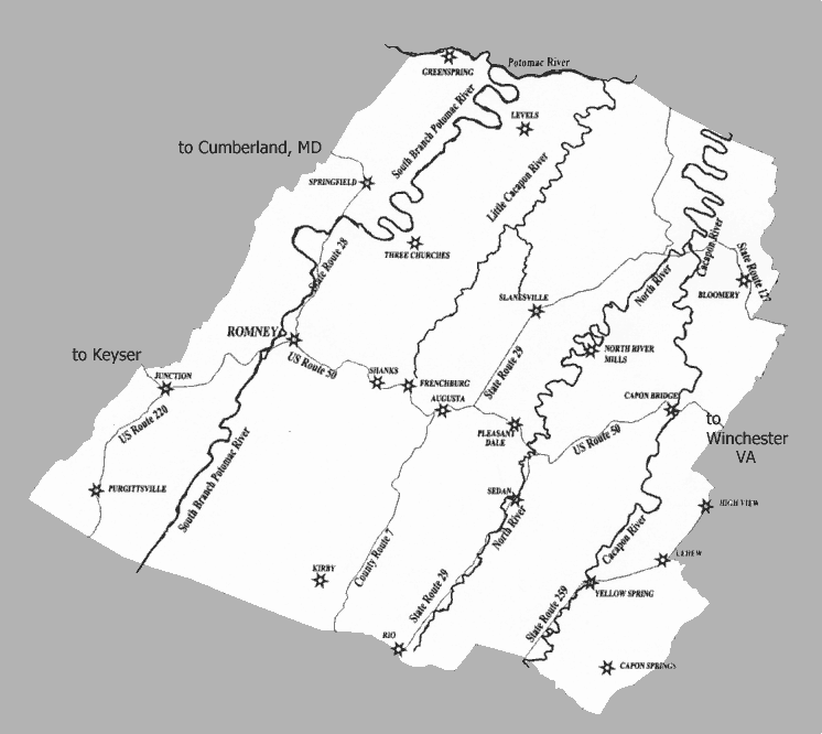
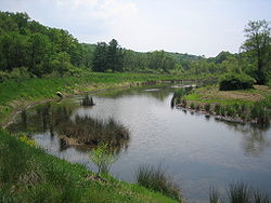
Rivers and streams
- Potomac RiverPotomac RiverThe Potomac River flows into the Chesapeake Bay, located along the mid-Atlantic coast of the United States. The river is approximately long, with a drainage area of about 14,700 square miles...
- Cacapon RiverCacapon RiverThe Cacapon River , located in the Appalachian Mountains of West Virginia's Eastern Panhandle region, is an river known for its fishing, boating, wildlife, and scenery...
- Capon Springs RunCapon Springs RunCapon Springs Run is a tributary stream of the Cacapon River in Hampshire County of West Virginia's Eastern Panhandle. Capon Springs Run is a shallow, stony, non-navigable stream fed by the famous "Capon Springs" at its source on the flanks of Great North Mountain east of the hamlet of Capon Springs...
- Dillons RunDillons RunDillons Run is a tributary stream of the Cacapon River, belonging to the Potomac River and Chesapeake Bay watersheds. The stream is located in Hampshire County in the U.S. state of West Virginia's Eastern Panhandle.-Headwaters and course:...
- Edwards RunEdwards RunEdwards Run is a tributary stream of the Cacapon River, belonging to the Potomac River and Chesapeake Bay watersheds. The stream is located in Hampshire County in the U.S. state of West Virginia's Eastern Panhandle. Edwards Run is named for Joseph Edwards and his family, whose plantation...
- Mill BranchMill Branch (Cacapon River)Mill Branch is a tributary stream of the Cacapon River, belonging to the Potomac River and Chesapeake Bay watersheds. The stream is located in eastern Hampshire County in West Virginia's Eastern Panhandle.-Headwaters and course:...
- North RiverNorth River (Cacapon River)North River is a tributary of the Cacapon River, belonging to the Potomac River and Chesapeake Bay watersheds. The river is located in Hampshire and Hardy counties in the U.S. state of West Virginia's Eastern Panhandle. The mouth of North River into the Cacapon is located at Forks of Cacapon...
- Grassy Lick RunGrassy Lick RunGrassy Lick Run is a tributary stream of the North River, itself a tributary of the Cacapon River, making it a part of the Potomac River and Chesapeake Bay watersheds. Grassy Lick Run flows south through the community of Kirby....
- Tearcoat CreekTearcoat CreekTearcoat Creek is an free-flowing tributary stream of the North River, itself a tributary of the Cacapon River, making it a part of the Potomac River and Chesapeake Bay watersheds. The creek is located in central Hampshire County, West Virginia...
- Bearwallow CreekBearwallow CreekBearwallow Creek is a tributary stream of Tearcoat Creek, itself a tributary of the North River, making it a part of the Potomac River and Chesapeake Bay watersheds. Bearwallow Creek is located in Hampshire County, West Virginia...
- Bearwallow Creek
- Grassy Lick Run
- Capon Springs Run
- Little Cacapon RiverLittle Cacapon RiverThe Little Cacapon River is a free-flowing tributary of the Potomac River in the center of Hampshire County, West Virginia. Via the Potomac River, its waters are part of the Chesapeake Bay watershed, leading to the Atlantic Ocean. The Little Cacapon at an elevation of near the community of...
- North Fork Little Cacapon River
- South Fork Little Cacapon River
- North Branch Potomac River
- Green Spring RunGreen Spring RunGreen Spring Run is an tributary stream of the North Branch Potomac River in Hampshire County in the U.S. state of West Virginia. Green Spring Run rises in Greenwood Hollow north of Springfield and meanders northeast through Green Spring Valley. The South Branch Valley Railroad and Green Spring...
- Green Spring Run
- South Branch Potomac River
- Big RunBig Run (South Branch Potomac River)Big Run is a tributary stream of the South Branch Potomac River, belonging to the Potomac River and Chesapeake Bay watersheds. Big Run flows through the city of Romney and the campus of the West Virginia Schools for the Deaf and Blind in Hampshire County, West Virginia...
- Buffalo CreekBuffalo Creek (South Branch Potomac River)Buffalo Creek is a free-flowing tributary stream of the South Branch Potomac River, itself a tributary of the Potomac River, making it a part of the Chesapeake Bay watershed. Buffalo Creek is located in west-central Hampshire County in the U.S. state of West Virginia...
- Mill CreekMill Creek (South Branch Potomac River)Mill Creek is a tributary stream of the South Branch Potomac River, belonging to the Potomac River and Chesapeake Bay watersheds. The stream is located in Hampshire County in West Virginia's Eastern Panhandle. Mill Creek flows into the South Branch west of Romney Bridge near Vanderlip along the...
- Mill RunMill Run (South Branch Potomac River)Mill Run is a tributary stream of the South Branch Potomac River, belonging to the Potomac River and Chesapeake Bay watersheds. The stream is located in Hampshire County in the Eastern Panhandle of the U.S. state of West Virginia...
- Big Run
- Cacapon River
Mountains
- South Branch MountainSouth Branch MountainSouth Branch Mountain is a mountain ridge that runs southwest to northeast through Hampshire and Hardy counties in the Eastern Panhandle of the U.S. state of West Virginia, rising to its greatest elevation of 3,028 feet above sea-level in the Nathaniel Mountain Wildlife Management Area...
, 3028 feet (922 m) - Pinnacle Ridge, 2844 feet (866.85 m)
- Nathaniel MountainNathaniel MountainNathaniel Mountain is a mountain ridge that runs southwest northeast through Hampshire County in West Virginia's Eastern Panhandle, rising to its greatest elevation of above sea-level. The mountain is bound at its western flank by the South Branch Potomac River and to its eastern flank by South...
, 2739 feet (834 m) - Mill Creek MountainMill Creek MountainMill Creek Mountain is a continuous mountain ridge that runs northeast through Hampshire and Hardy counties in the Eastern Panhandle region of the U.S. state of West Virginia. Rising to its greatest elevation of 2,648 feet above sea-level at High Knob, Mill Creek is a folded mountain ridge,...
, 2648 feet (807 m) - Cacapon MountainCacapon MountainCacapon Mountain runs northwest through Morgan and Hampshire counties in West Virginia's Eastern Panhandle, rising to its greatest elevation of 2,618 feet above sea-level at High Point. Cacapon Mountain is a folded mountain ridge, belonging to the Appalachian Ridge and Valley Province. Cacapon...
, 2618 feet (797 m) - Spring Mountain, 2436 feet (742.49 m)
- Spring Gap MountainSpring Gap MountainSpring Gap Mountain runs southwest northeast through Morgan and Hampshire counties in West Virginia's Eastern Panhandle, rising to its greatest elevation of north of "Spring Gap", from which the mountain takes its name...
, 2237 feet (681 m) - North River MountainNorth River MountainNorth River Mountain is a mountain ridge that runs southwest to northeast in Hampshire County, West Virginia, United States. Named for the North River that parallels its western flanks for its entire length, North River Mountain reaches its highest elevation of near the community of Delray. North...
, 2149 feet (655 m) - Cooper MountainCooper MountainCooper Mountain runs southwest northeast through Hampshire County in West Virginia's Eastern Panhandle, rising to its greatest elevation of above sea-level at Bens Knob. The mountain's other knob, Butchers Knob, has an elevation of . Cooper Mountain is flanked to its west by North River Mountain...
, 2028 feet (618 m) - Baker Mountain, 2024 feet (616 m)
- Patterson Creek MountainPatterson Creek MountainPatterson Creek Mountain is a mountain ridge that forms the border between Mineral and Hampshire counties and Grant and Hardy Counties in West Virginia's Eastern Panhandle. The mountain's namesake, Patterson Creek, parallels its western flank...
, 2005 feet (611 m) - Sideling HillSideling HillSideling Hill is a long, steep, narrow mountain ridge in the Ridge-and-Valley physiographic province of the Appalachian Mountains, located in Washington County in western Maryland and adjacent West Virginia and Pennsylvania, USA...
, 1930 feet (588 m) - Little Cacapon MountainLittle Cacapon MountainLittle Cacapon Mountain is a mountain ridge of the Ridge-and-valley Appalachians in Hampshire County, West Virginia, United States. The mountain takes its name from the Little Cacapon River, a Potomac River tributary that lies on its western flanks. Little Cacapon Mountain reaches its highest point...
, 1575 feet (480 m) - Ice MountainIce MountainIce Mountain is a mountain ridge and algific talus slope that is part of a preserve near the community of North River Mills in Hampshire County, West Virginia, United States....
, 1489 feet (453 m) - The Devil's NoseThe Devil's NoseThe Devil's Nose is a steep but small mountain ridge that spans southwest northeast between the Little Cacapon and Potomac rivers in northeastern Hampshire County, West Virginia. From its southern end near Neals Run on Johnsons Hollow, The Nose rises from the landscape curving along a bend in the...
, 1121 feet (341 m)
Other geological formations
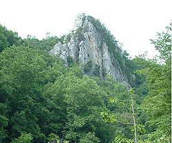
- Caudy's CastleCaudy's CastleCaudy's Castle is a rock pinnacle of Ridgeley sandstone that stands 1,400 feet above sea level over the Cacapon River near the Bloomery Pike south of Forks of Cacapon in Hampshire County, West Virginia...
- Hanging RocksHanging RocksHanging Rocks are perpendicular cliffs rising nearly above the South Branch Potomac River in Hampshire County in the U.S. state of West Virginia. Hanging Rocks are located four miles north of Romney at Wappocomo on West Virginia Route 28. Hanging Rocks has also been known throughout its history...
- Mechanicsburg GapMechanicsburg GapMechanicsburg Gap is a water gap mountain pass through Mill Creek Mountain in Hampshire County in the U.S. state of West Virginia....
- The TroughThe TroughThe Trough is a large river gorge carved by the South Branch Potomac River and situated in the Allegheny Mountains of Hampshire and Hardy Counties, West Virginia, USA...
Hampshire County maps
- Hampshire County's Original Boundaries
- Civil War Era Hampshire County
- Hampshire County in 1880
- Hampshire County in 1888
- WVDEP Modern Hampshire County Road Map
- Hampshire County in the 1755 Fry & Jefferson Map
Demographics
| > | Year | Population |
|---|---|
| 1790 | 7,346 |
| 1800 | 8,348 |
| 1810 | 9,784 |
| 1820 | 10,889 |
| 1830 | 11,279 |
| 1840 | 12,295 |
| 1850 | 14,036 |
| 1860 | 13,913 |
| 1870 | 7,643 |
| 1880 | 10,366 |
| 1890 | 11,419 |
As of the census
Census
A census is the procedure of systematically acquiring and recording information about the members of a given population. It is a regularly occurring and official count of a particular population. The term is used mostly in connection with national population and housing censuses; other common...
of 2000, there were 20,203 people, 7,955 households, and 5,640 families residing in the county. The population density
Population density
Population density is a measurement of population per unit area or unit volume. It is frequently applied to living organisms, and particularly to humans...
was 32 people per square mile (12/km²). There were 11,185 housing units at an average density of 17 per square mile (7/km²). The racial makeup of the county was 98.04% White
Race (United States Census)
Race and ethnicity in the United States Census, as defined by the Federal Office of Management and Budget and the United States Census Bureau, are self-identification data items in which residents choose the race or races with which they most closely identify, and indicate whether or not they are...
, 0.83% Black
Race (United States Census)
Race and ethnicity in the United States Census, as defined by the Federal Office of Management and Budget and the United States Census Bureau, are self-identification data items in which residents choose the race or races with which they most closely identify, and indicate whether or not they are...
or African American
Race (United States Census)
Race and ethnicity in the United States Census, as defined by the Federal Office of Management and Budget and the United States Census Bureau, are self-identification data items in which residents choose the race or races with which they most closely identify, and indicate whether or not they are...
, 0.24% Native American
Race (United States Census)
Race and ethnicity in the United States Census, as defined by the Federal Office of Management and Budget and the United States Census Bureau, are self-identification data items in which residents choose the race or races with which they most closely identify, and indicate whether or not they are...
, 0.16% Asian
Race (United States Census)
Race and ethnicity in the United States Census, as defined by the Federal Office of Management and Budget and the United States Census Bureau, are self-identification data items in which residents choose the race or races with which they most closely identify, and indicate whether or not they are...
, 0.02% Pacific Islander
Race (United States Census)
Race and ethnicity in the United States Census, as defined by the Federal Office of Management and Budget and the United States Census Bureau, are self-identification data items in which residents choose the race or races with which they most closely identify, and indicate whether or not they are...
, 0.12% from other races
Race (United States Census)
Race and ethnicity in the United States Census, as defined by the Federal Office of Management and Budget and the United States Census Bureau, are self-identification data items in which residents choose the race or races with which they most closely identify, and indicate whether or not they are...
, and 0.59% from two or more races. 0.55% of the population were Hispanic
Race (United States Census)
Race and ethnicity in the United States Census, as defined by the Federal Office of Management and Budget and the United States Census Bureau, are self-identification data items in which residents choose the race or races with which they most closely identify, and indicate whether or not they are...
or Latino
Race (United States Census)
Race and ethnicity in the United States Census, as defined by the Federal Office of Management and Budget and the United States Census Bureau, are self-identification data items in which residents choose the race or races with which they most closely identify, and indicate whether or not they are...
of any race.
There were 7,955 households out of which 31.30% had children under the age of 18 living with them, 56.70% were married couples
Marriage
Marriage is a social union or legal contract between people that creates kinship. It is an institution in which interpersonal relationships, usually intimate and sexual, are acknowledged in a variety of ways, depending on the culture or subculture in which it is found...
living together, 9.50% had a female householder with no husband present, and 29.10% were non-families. 24.60% of all households were made up of individuals and 10.60% had someone living alone who was 65 years of age or older. The average household size was 2.49 and the average family size was 2.94.
In the county, the population was spread out with 25.10% under the age of 18, 7.10% from 18 to 24, 27.60% from 25 to 44, 25.60% from 45 to 64, and 14.60% who were 65 years of age or older. The median age was 38 years. For every 100 females there were 99.70 males. For every 100 females age 18 and over, there were 97.30 males.
The median income for a household in the county was $31,666, and the median income for a family was $37,616. Males had a median income of $28,884 versus $19,945 for females. The per capita income
Per capita income
Per capita income or income per person is a measure of mean income within an economic aggregate, such as a country or city. It is calculated by taking a measure of all sources of income in the aggregate and dividing it by the total population...
for the county was $14,851. About 12.90% of families and 16.30% of the population were below the poverty line, including 22.70% of those under age 18 and 13.10% of those age 65 or over.
County parks
- Central Hampshire Park, Augusta
- Green Spring Recreational Park, Green Spring
- Hampshire Park & 4-H Camp, Romney
- Romney Recreation Center, Romney
- Shanks Roadside Park, Shanks
Wildlife management areas
- Edwards Run Wildlife Management AreaEdwards Run Wildlife Management AreaEdwards Run Wildlife Management Area is located on two miles north of Capon Bridge on Cold Stream Road near Cold Stream in Hampshire County, West Virginia...
- Fort Mill Ridge Wildlife Management AreaFort Mill Ridge Wildlife Management AreaThe Fort Mill Ridge Wildlife Management Area is located on two miles southwest of Romney in Hampshire County, West Virginia. Fort Mill Ridge WMA is owned by the West Virginia Division of Natural Resources...
- Nathaniel Mountain Wildlife Management AreaNathaniel Mountain Wildlife Management AreaNathaniel Mountain Wildlife Management Area is located on south of Romney in Hampshire County, West Virginia. The wildlife management area's principle access road is off of Grassy Lick Road . Nathaniel Mountain is one of West Virginia's largest and most important wildlife management areas...
- Short Mountain Wildlife Management AreaShort Mountain Wildlife Management AreaShort Mountain Wildlife Management Area is located on eight miles south of Augusta off Augusta-Ford Hill Road in Hampshire County, West Virginia...
- South Branch Wildlife Management AreaSouth Branch Wildlife Management AreaThe South Branch Wildlife Management Area is of mixed oak-hickory woodlands and pastures in Hampshire and Hardy Counties, West Virginia, USA. The South Branch WMA consists of four separate tracts along the South Branch Potomac River around and south of the river gorge known as The Trough...
- Wardensville Wildlife Management Area
Public schools
- Hampshire County SchoolsHampshire County SchoolsHampshire County Schools is the operating school district within Hampshire County, West Virginia. It is governed by the Hampshire County Board of Education.-High schools:Serves grades 9-12*Hampshire High School , Romney-Middle schools:Serves grades 6-8...
- West Virginia Schools for the Deaf and BlindWest Virginia Schools for the Deaf and BlindThe West Virginia Schools for the Deaf and Blind were established by an Act of the Legislature on March 3, 1870. The School for the Deaf and the School for the Blind offer comprehensive educational programs for hearing impaired and visually impaired students respectively. There is also a unit for...
Earliest European settlers
RomneyRomney, West Virginia
Romney is a city in and the county seat of Hampshire County, West Virginia, United States. The population was 1,940 at the 2000 census, while the area covered by the city's ZIP code had a population of 5,873. It is a city with a very historic background dating back to the 18th century...
was initially settled by hunters and traders around 1725. In 1738, John Pearsall (or Pearsoll) and his brother Job built homes and in 1758 a fort (Fort Pearsall
Fort Pearsall
Fort Pearsall was an early frontier fort constructed in 1756 in Romney, West Virginia to protect local settlers in the South Branch Potomac River valley against Native American raids...
) for defense against Native Americans
Native Americans in the United States
Native Americans in the United States are the indigenous peoples in North America within the boundaries of the present-day continental United States, parts of Alaska, and the island state of Hawaii. They are composed of numerous, distinct tribes, states, and ethnic groups, many of which survive as...
in present-day Romney. Their settlement was then known as Pearsall's Flats. In 1748, Thomas Fairfax, 6th Lord Fairfax of Cameron
Thomas Fairfax, 6th Lord Fairfax of Cameron
Thomas Fairfax, 6th Lord Fairfax of Cameron was the son of Thomas Fairfax, 5th Lord Fairfax of Cameron and of Catherine, daughter of Thomas Culpeper, 2nd Baron Culpeper of Thoresway....
sent a surveying party, including 16 year-old George Washington
George Washington
George Washington was the dominant military and political leader of the new United States of America from 1775 to 1799. He led the American victory over Great Britain in the American Revolutionary War as commander-in-chief of the Continental Army from 1775 to 1783, and presided over the writing of...
, to survey his lands along the Potomac
Potomac River
The Potomac River flows into the Chesapeake Bay, located along the mid-Atlantic coast of the United States. The river is approximately long, with a drainage area of about 14,700 square miles...
and South Branch Potomac river
River
A river is a natural watercourse, usually freshwater, flowing towards an ocean, a lake, a sea, or another river. In a few cases, a river simply flows into the ground or dries up completely before reaching another body of water. Small rivers may also be called by several other names, including...
s. Washington spent three summers and falls surveying Lord Fairfax's Northern Neck
Northern Neck
The Northern Neck is the northernmost of three peninsulas on the western shore of the Chesapeake Bay in the Commonwealth of Virginia. This peninsula is bounded by the Potomac River on the north and the Rappahannock River on the south. It encompasses the following Virginia counties: Lancaster,...
estate, which included all of the present-day Eastern Panhandle of West Virginia
Eastern Panhandle of West Virginia
The Eastern Panhandle of West Virginia is a narrow stretch of territory in the northeast of the state, bordering Maryland and Virginia, United States. The Eastern Panhandle Board of Realtors and other local civic organizations consider only the three Easternmost counties, Jefferson, Berkeley and...
. In April 1748, he laid off several lots in an area known as the Trough
The Trough
The Trough is a large river gorge carved by the South Branch Potomac River and situated in the Allegheny Mountains of Hampshire and Hardy Counties, West Virginia, USA...
, about ten miles (16 km) south of Romney, and he is known to have been in present-day Romney on October 19, 1749. Oral traditions claimed that Washington laid present-day Romney out into lots at that time, but written records from that era indicate that Romney was surveyed and laid out into lots by James Genn
James Genn
James Douglas Genn is a filmmaker, writer and director, born in Vancouver, British Columbia in 1972.He is the son of Canadian artist Robert Genn, the brother of musician Dave Genn, and is the twin brother to artist and musician Sara Genn...
prior to Washington's arrival. Genn was also employed by Lord Fairfax.
18th century Hampshire County
In 1756, Fort PearsallFort Pearsall
Fort Pearsall was an early frontier fort constructed in 1756 in Romney, West Virginia to protect local settlers in the South Branch Potomac River valley against Native American raids...
was constructed on Job Pearsall's plantation for protection against Native American
Native Americans in the United States
Native Americans in the United States are the indigenous peoples in North America within the boundaries of the present-day continental United States, parts of Alaska, and the island state of Hawaii. They are composed of numerous, distinct tribes, states, and ethnic groups, many of which survive as...
raids and George Washington provisioned and garrisoned the Fort at various times until 1758. At that time, there were at least 100 people living in the general area. Following the end of hostilities in the area, Lord Fairfax recognized that more settlers would be interested in moving into the area and that he could earn some extra revenue by selling plots in the town. He sent a survey party to Romney in 1762 to formally lay out the town into 100 lots. At that time, he renamed the town Romney, in honor of the Cinque Ports
Cinque Ports
The Confederation of Cinque Ports is a historic series of coastal towns in Kent and Sussex. It was originally formed for military and trade purposes, but is now entirely ceremonial. It lies at the eastern end of the English Channel, where the crossing to the continent is narrowest...
city on the English Channel
English Channel
The English Channel , often referred to simply as the Channel, is an arm of the Atlantic Ocean that separates southern England from northern France, and joins the North Sea to the Atlantic. It is about long and varies in width from at its widest to in the Strait of Dover...
in Kent
Kent
Kent is a county in southeast England, and is one of the home counties. It borders East Sussex, Surrey and Greater London and has a defined boundary with Essex in the middle of the Thames Estuary. The ceremonial county boundaries of Kent include the shire county of Kent and the unitary borough of...
.
Confusion ensued for several decades concerning land ownership within the town as counterclaims were made by the original settlers and those who purchased lots laid out by Lord Fairfax's surveyors.
The first meeting of the Hampshire County Court was held in 1757, at Fort Pleasant
Fort Pleasant
Fort Pleasant, also known as the Isaac Van Meter House, is a historic home located near the unincorporated community of Old Fields north of Moorefield, Hardy County, West Virginia. The residence was completed by Isaac Van Meter and his wife Elizabeth Inskeep Van Meter by the late 18th century, and...
, now Old Fields
Old Fields, West Virginia
Old Fields is an unincorporated community on the South Branch Potomac River in northern Hardy County, West Virginia, USA.According to the Geographic Names Information System, Old Fields has also been known throughout its history as Indian Old Field, Indian Old Fields, and Oldfields.-History:The...
in Hardy County, and was presided by the Right Honorable Thomas Bryan Martin
Thomas Bryan Martin
Colonel Thomas Bryan Martin was an early American jurist, legislator, and prominent landowner.-Biography:Martin was born in England to Denny Martin and his wife, Frances Fairfax , sister of Thomas Fairfax, 6th Lord Fairfax of Cameron , and arrived in Virginia from England in 1751...
, Lord Fairfax's nephew. By that time, Hampshire County's population had fallen dramatically as most of the settlers had fled the county in fear of the Native Americans. The only families remaining lived near Fort Pearsall, near present-day Romney, and Fort Edwards
Fort Edwards
Fort Edwards can refer to:* A French and Indian War fort near Capon Bridge, West Virginia* A 19th-century US Army and trading post near Warsaw, Illinois, discussed in Fort Johnson* A Boer War fort in South Africa discussed in Breaker Morant...
, at present-day Capon Bridge
Capon Bridge, West Virginia
Capon Bridge is a town located in eastern Hampshire County, West Virginia along the Northwestern Turnpike , approximately twenty miles west of Winchester, Virginia. As of the 2000 census, the town population was 2,178, 200 of which live within the town limits. Originally known as Glencoe, Capon...
on the Cacapon River
Cacapon River
The Cacapon River , located in the Appalachian Mountains of West Virginia's Eastern Panhandle region, is an river known for its fishing, boating, wildlife, and scenery...
. The vast majority of the remaining settlers, however, were in the vicinity of present Old Fields-Moorefield-Petersburg and were protected by the several forts in the area, including Fort Pleasant
Once the Native Americans were defeated at the Battle of Point Pleasant
Battle of Point Pleasant
The Battle of Point Pleasant, known as the Battle of Kanawha in some older accounts, was the only major battle of Dunmore's War. It was fought on October 10, 1774, primarily between Virginia militia and American Indians from the Shawnee and Mingo tribes...
in 1774 settlers, once again, returned to the county. By 1790, when the first national census was taken, Hampshire County had 7,346 residents, making it the second most populous county in the present state of West Virginia at that time. Berkeley
Berkeley County, West Virginia
Berkeley County is a county located in the Eastern Panhandle region of the U.S. state of West Virginia. As of 2010, the population is 104,169, making it the second-most populous county in West Virginia, behind Kanawha...
was the most populous county, with 19,713 people. There were nine counties that comprised the present state, with a total population of 55,873 people.
During the Whiskey Rebellion
Whiskey Rebellion
The Whiskey Rebellion, or Whiskey Insurrection, was a tax protest in the United States in the 1790s, during the presidency of George Washington. Farmers who sold their corn in the form of whiskey had to pay a new tax which they strongly resented...
in 1794, many Hampshire County men volunteered to serve under Major General Daniel Morgan
Daniel Morgan
Daniel Morgan was an American pioneer, soldier, and United States Representative from Virginia. One of the most gifted battlefield tacticians of the American Revolutionary War, he later commanded troops during the suppression of the Whiskey Rebellion.-Early years:Most authorities believe that...
to put down the insurrection. The men most likely volunteered at Moorefield
Moorefield, West Virginia
Moorefield is a town in Hardy County, West Virginia, USA. Moorefield is the county seat of Hardy County. It was originally chartered in 1777 and named for Conrad Moore, who owned the land upon which the town was laid out...
in Hardy County
Hardy County, West Virginia
As of the census of 2000, there were 12,669 people, 5,204 households, and 3,564 families residing in the county. The population density was 22 people per square mile . There were 7,115 housing units at an average density of 12 per square mile...
and then marched north to Cumberland, Maryland
Cumberland, Maryland
Cumberland is a city in the far western, Appalachian portion of Maryland, United States. It is the county seat of Allegany County, and the primary city of the Cumberland, MD-WV Metropolitan Statistical Area. At the 2010 census, the city had a population of 20,859, and the metropolitan area had a...
. Approximately 1,200 of the 12,950 men under Morgan's command came from the area that would later become West Virginia.
Early Churches
The early missionaries helped to sustain the religious faith of the early European inhabitants. In 1775 two BaptistBaptist
Baptists comprise a group of Christian denominations and churches that subscribe to a doctrine that baptism should be performed only for professing believers , and that it must be done by immersion...
missionaries among a group of settlers moved to the Cacapon
Cacapon River
The Cacapon River , located in the Appalachian Mountains of West Virginia's Eastern Panhandle region, is an river known for its fishing, boating, wildlife, and scenery...
and organized the first European church in the county. In 1771 the work of the Methodist Episcopal Church
Methodist Episcopal Church
The Methodist Episcopal Church, sometimes referred to as the M.E. Church, was a development of the first expression of Methodism in the United States. It officially began at the Baltimore Christmas Conference in 1784, with Francis Asbury and Thomas Coke as the first bishops. Through a series of...
was begun, in which later developments led to the formation of the Methodist Episcopal Church, South
Methodist Episcopal Church, South
The Methodist Episcopal Church, South, or Methodist Episcopal Church South, was the so-called "Southern Methodist Church" resulting from the split over the issue of slavery in the Methodist Episcopal Church which had been brewing over several years until it came out into the open at a conference...
. In 1753 Hampshire County had been formed into a parish by the Protestant Episcopal Church and in 1773 a missionary sent by that church began work. In 1787 a Primitive Baptist
Primitive Baptist
Primitive Baptists, also known as Hard Shell Baptists or Anti-Mission Baptists, are conservative, Calvinist Baptists adhering to beliefs that formed out of the controversy among Baptists in the early 1800’s over the appropriateness of mission boards, bible tract societies, and temperance...
church was established at North River. Soon after the American Revolution
American Revolution
The American Revolution was the political upheaval during the last half of the 18th century in which thirteen colonies in North America joined together to break free from the British Empire, combining to become the United States of America...
there was preaching by the Presbyterians at different points in the county. In 1792 a Presbyterian church was organized at Romney and another, Mount Bethel Church
Mount Bethel Church
Mount Bethel Church is a Presbyterian church located at the junction of County Route 5 and County Route 5/4 in the unincorporated community of Three Churches north of Romney in Hampshire County, West Virginia, United States.The Presbyterians established a church near here in 1792...
, at Three Churches
Three Churches, West Virginia
Three Churches is an unincorporated community in Hampshire County in the U.S. state of West Virginia. The town is located north of Romney along Jersey Mountain Road at a crossroads with Three Churches Hollow Road...
.
Early Industry
The wide lowlands of Hampshire County certainly invited agricultureAgriculture
Agriculture is the cultivation of animals, plants, fungi and other life forms for food, fiber, and other products used to sustain life. Agriculture was the key implement in the rise of sedentary human civilization, whereby farming of domesticated species created food surpluses that nurtured the...
, and fields of wheat
Wheat
Wheat is a cereal grain, originally from the Levant region of the Near East, but now cultivated worldwide. In 2007 world production of wheat was 607 million tons, making it the third most-produced cereal after maize and rice...
and tobacco
Tobacco
Tobacco is an agricultural product processed from the leaves of plants in the genus Nicotiana. It can be consumed, used as a pesticide and, in the form of nicotine tartrate, used in some medicines...
surrounded the important truck-patch of the settler. The rolling uplands offered pasturage for horses, cattle, sheep, and hogs, which were driven across country to market at Winchester
Winchester, Virginia
Winchester is an independent city located in the northwestern portion of the Commonwealth of Virginia in the USA. The city's population was 26,203 according to the 2010 Census...
. The streams abounded in fish and the mountains contained not only game but timber and stone for early settlers' homes. The limestone was burned for lime at Bloomery Gap, where remains of old lime-kilns give evidence of an early industry. Soon it was discovered that some of the strata contained iron ore. Much of it was transported to present-day Keyser
Keyser, West Virginia
Keyser is a city in and the county seat of Mineral County, West Virginia, United States. It is part of the Cumberland, MD-WV Metropolitan Statistical Area. The population was 5,303 at the 2000 census.- History :...
, from an area along South Branch Potomac River south of the present limits of the county. In Bloomery Gap, a ruined furnace still stands, mute evidence of another former industry. In the early days the increasing population stimulated not only farming and grazing but every industry of a new country.Hampshire County was also known for its many gunmakers,located on or near the main road from Winchester to Romney.Among them were,Henry Topper,Jacob Kline,George Young, Benjamin Shane,George Glaze,William Britton and the Sheetz Family.
19th century Hampshire County
Northwestern Turnpike
The Northwestern Turnpike is a historic road in West Virginia , important for being historically one of the major roads crossing the Appalachians, financed by the Virginia Board of Public Works in the 1830s. In modern times, west of Winchester, Virginia, U.S...
(U.S. Route 50
U.S. Route 50
U.S. Route 50 is a major east–west route of the U.S. Highway system, stretching just over from Ocean City, Maryland on the Atlantic Ocean to West Sacramento, California. Until 1972, when it was replaced by Interstate Highways west of the Sacramento area, it extended to San Francisco, near...
) was an integral part of the development of Hampshire County. General Daniel Morgan first suggested the road be built in 1748, but his recommendations were not acted upon until the 1830s. Colonel Claudius Crozet
Claudius Crozet
Benoit Claudius Crozet was an educator and civil engineer.Crozet was born in France. After serving in the French military, in 1816, he immigrated to the United States. He taught at the U.S. Military Academy at West Point, New York, and helped found the Virginia Military Institute at Lexington,...
, a Frenchman who had previously worked for Napoleon Bonaparte, engineered the road which connected Parkersburg
Parkersburg, West Virginia
As of the census of 2000, there were 33,099 people, 14,467 households, and 8,767 families residing in the city. In 2006 the U.S. Census Bureau estimated that Parkersburg's population had decreased 4.4% to 31,755. The population density was 2,800.5 people per square mile . There were 16,100 housing...
with Winchester, Virginia. The turnpike traversed Hampshire County stretching through the communities of Capon Bridge, Loom
Loom, West Virginia
Loom is an unincorporated community in Hampshire County, West Virginia, USA. Loom is located between Capon Bridge and Hanging Rock along the Northwestern Turnpike on the western flanks of Cooper Mountain...
, Hanging Rock
Hanging Rock, West Virginia
Hanging Rock is an unincorporated community in Hampshire County in the U.S. state of West Virginia. Hanging Rock is named for the "Hanging Rock" outcrop that hangs over the Northwestern Turnpike . It should not be confused with the plural "Hanging Rocks" over the South Branch Potomac River north of...
, Pleasant Dale
Pleasant Dale, West Virginia
Pleasant Dale is an unincorporated community in Hampshire County in the U.S. state of West Virginia. Pleasant Dale is located between Capon Bridge and Augusta on the Northwestern Turnpike . Tearcoat Creek flows through Pleasant Dale and offers whitewater rafting in the Spring from the U.S. Route 50...
, Augusta
Augusta, West Virginia
Augusta is an unincorporated community in central Hampshire County, West Virginia. It is located along the Northwestern Turnpike at the northern terminus of Augusta-Ford Hill Road between Shanks and Pleasant Dale, east of Romney...
, Frenchburg
Frenchburg, West Virginia
Frenchburg is an unincorporated community in Hampshire County in the U.S. state of West Virginia. Frenchburg is located along the Northwestern Turnpike where the Little Cacapon River is formed by the confluence of the North and South forks of the Little Cacapon east of Shanks...
, Shanks
Shanks, West Virginia
Shanks is an unincorporated community in Hampshire County in the U.S. state of West Virginia. According to the 2000 census, the Shanks community has a population of 806....
, and Romney
Romney, West Virginia
Romney is a city in and the county seat of Hampshire County, West Virginia, United States. The population was 1,940 at the 2000 census, while the area covered by the city's ZIP code had a population of 5,873. It is a city with a very historic background dating back to the 18th century...
. Through the years, Romney became an important rest stop for travelers on the turnpike. This aided the local economy as hotels and taverns began to appear in the area.
During the American Civil War
American Civil War
The American Civil War was a civil war fought in the United States of America. In response to the election of Abraham Lincoln as President of the United States, 11 southern slave states declared their secession from the United States and formed the Confederate States of America ; the other 25...
, the Hampshire Guards and Frontier Riflemen joined the Confederate Army
Confederate States of America
The Confederate States of America was a government set up from 1861 to 1865 by 11 Southern slave states of the United States of America that had declared their secession from the U.S...
. Although there were no major battles in Hampshire County, Romney changed hands at least fifty-six times during the war. It was often a case of one army evacuating the area allowing the opposing army to move into the town. This places Romney second behind Winchester as the town that changed hands the most during the American Civil War. On June 11, 1861, it changed hands twice in the same day. Some local Hampshire County historians speculate that Romney actually changed hands more than Winchester but there are no surviving records to support the claim.
Sites on the National Register of Historic Places
| Site | Year Built | Address | Community | Listed |
|---|---|---|---|---|
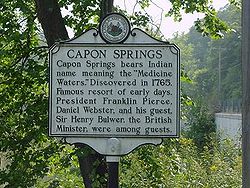
| Capon Springs Historic District Capon Springs Resort Capon Springs, also known as Frye's Springs and Watson Town, is a national historic district in Capon Springs, West Virginia that includes a number of resort buildings ranging in age from the mid-nineteenth century to the early twentieth century... |
18th-19th centuries | Capon Springs Road (CR 16) | Capon Springs Capon Springs, West Virginia Capon Springs is an unincorporated hamlet in Hampshire County, West Virginia, USA. According to the 2000 census, the Capon Springs community has a population of 95.... |
1993 |
| Captain David Pugh House Captain David Pugh House The Captain David Pugh House is a historic 19th century Federal style residence on the Cacapon River in the unincorporated community of Hooks Mills in Hampshire County, West Virginia, United States. It is also known by its past name, Riversdell. It is a 2 1/2 story frame dwelling built in 1835. ... |
1835 | Cacapon River Road (CR 14) | Hooks Mills Hooks Mills, West Virginia Hooks Mills is an unincorporated community in Hampshire County, West Virginia, United States. It is located on Hooks Mill Road which intersects Cacapon River Road 4.5 miles south of Capon Bridge... |
2004 |
| Fort Van Meter Fort Van Meter Fort Van Meter — also known as Fort Pleasant and Town Fort — was an 18th century frontier fort in the South Branch Potomac River Valley south of Romney in Hampshire County, West Virginia, USA. It is located approximately a mile and a half north of the rugged river gorge known as The Trough... |
circa 1756 | South Branch River Road (CR 8) | Romney Romney, West Virginia Romney is a city in and the county seat of Hampshire County, West Virginia, United States. The population was 1,940 at the 2000 census, while the area covered by the city's ZIP code had a population of 5,873. It is a city with a very historic background dating back to the 18th century... |
2009 |
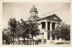
| Hampshire County Courthouse Hampshire County Courthouse (West Virginia) The Hampshire County Courthouse is a Neoclassical edifice in the center of downtown Romney, county seat of Hampshire County, West Virginia. The present building was constructed in 1922 to replace the previous 1833 Neoclassical courthouse that had been destroyed by fire in 1921... |
1922 | Main & High Streets | Romney Romney, West Virginia Romney is a city in and the county seat of Hampshire County, West Virginia, United States. The population was 1,940 at the 2000 census, while the area covered by the city's ZIP code had a population of 5,873. It is a city with a very historic background dating back to the 18th century... |
2005 |
| Hickory Grove | 1838 | South Branch River Road (CR 8) | Romney Romney, West Virginia Romney is a city in and the county seat of Hampshire County, West Virginia, United States. The population was 1,940 at the 2000 census, while the area covered by the city's ZIP code had a population of 5,873. It is a city with a very historic background dating back to the 18th century... |
2011 |
| Hook's Tavern | circa 1790 | Northwestern Turnpike Northwestern Turnpike The Northwestern Turnpike is a historic road in West Virginia , important for being historically one of the major roads crossing the Appalachians, financed by the Virginia Board of Public Works in the 1830s. In modern times, west of Winchester, Virginia, U.S... (US 50) |
Capon Bridge Capon Bridge, West Virginia Capon Bridge is a town located in eastern Hampshire County, West Virginia along the Northwestern Turnpike , approximately twenty miles west of Winchester, Virginia. As of the 2000 census, the town population was 2,178, 200 of which live within the town limits. Originally known as Glencoe, Capon... |
2011 |
| Kuykendall Polygonal Barn Kuykendall Polygonal Barn The Kuykendall Polygonal Barn was an early 20th-century polygonal barn in the South Branch Potomac River valley near Romney in Hampshire County, West Virginia. The Kuykendall Polygonal Barn was the only 15-sided barn built in West Virginia, and one of only a few such known to have been constructed... |
circa 1906 | South Branch River Road (CR 8) | Romney Romney, West Virginia Romney is a city in and the county seat of Hampshire County, West Virginia, United States. The population was 1,940 at the 2000 census, while the area covered by the city's ZIP code had a population of 5,873. It is a city with a very historic background dating back to the 18th century... |
1985 |
| Literary Hall Literary Hall Literary Hall is the historic former site of the Romney Literary Society and currently serves as a museum featuring local memorabilia in Romney, West Virginia, United States.-Romney Literary Society and the First Literary Hall:... |
1869–1870 | Main & High Streets | Romney Romney, West Virginia Romney is a city in and the county seat of Hampshire County, West Virginia, United States. The population was 1,940 at the 2000 census, while the area covered by the city's ZIP code had a population of 5,873. It is a city with a very historic background dating back to the 18th century... |
1979 |
| North River Mills Historic District North River Mills Historic District North River Mills Historic District is a national historic district located at North River Mills, Hampshire County, West Virginia. The district encompasses 25 contributing buildings and five contributing sites. The district lies along Hiett Run, which... |
18th-20th centuries | Cold Stream Road (CR 45/20) & North River Road (CR 4/2) | North River Mills North River Mills, West Virginia North River Mills is a historic unincorporated village in Hampshire County in the U.S. state of West Virginia. North River Mills is located between Capon Bridge and Slanesville on Cold Stream Road at its intersection with North River Road... |
2011 |
| Old Methodist District Parsonage Old Methodist District Parsonage The Old Methodist District Parsonage is a 19th century Italianate residence in Romney, West Virginia, United States. It is a two story brick dwelling constructed between 1868 and 1882 to serve as the district parsonage for the area's Methodist churches... |
1868–1882 | 351 North High Street (WV 28) | Romney Romney, West Virginia Romney is a city in and the county seat of Hampshire County, West Virginia, United States. The population was 1,940 at the 2000 census, while the area covered by the city's ZIP code had a population of 5,873. It is a city with a very historic background dating back to the 18th century... |
2005 |
| Scanlon Log House Scanlon Farm Scanlon Farm is a late 19th-century loghouse and farm overlooking Three Churches Run east of the unincorporated community of Three Churches, West Virginia... |
late 19th century | Three Churches Hollow Road (CR 5/4) | Three Churches Three Churches, West Virginia Three Churches is an unincorporated community in Hampshire County in the U.S. state of West Virginia. The town is located north of Romney along Jersey Mountain Road at a crossroads with Three Churches Hollow Road... |
1988 |
| Sloan-Parker House Sloan-Parker House The Sloan-Parker House or Stone House, constructed in 1790 of locally quarried fieldstone for Richard Sloan, was placed on the National Register of Historic Places in 1975. Located on the Northwestern Turnpike near Junction, West Virginia west of Romney it has served as a stage coach stop as well... |
1790 | Northwestern Turnpike Northwestern Turnpike The Northwestern Turnpike is a historic road in West Virginia , important for being historically one of the major roads crossing the Appalachians, financed by the Virginia Board of Public Works in the 1830s. In modern times, west of Winchester, Virginia, U.S... (US 50) |
Junction Junction, West Virginia Junction is an unincorporated community in Hampshire County in the U.S. state of West Virginia. Historically referred to as Moorefield Junction, Junction received its name because of its location at the crossroads of U.S. Highway 220/West Virginia Route 28 and the Northwestern Turnpike... |
1975 |
| Sycamore Dale Sycamore Dale Sycamore Dale is a 19th-century Greek Revival plantation home overlooking the South Branch Potomac River southwest of Romney, West Virginia. Sycamore Dale is one of several historic estates along South Branch River Road... |
1836 | South Branch River Road (CR 8) | Romney Romney, West Virginia Romney is a city in and the county seat of Hampshire County, West Virginia, United States. The population was 1,940 at the 2000 census, while the area covered by the city's ZIP code had a population of 5,873. It is a city with a very historic background dating back to the 18th century... |
1980 |
| Washington Bottom Farm Washington Bottom Farm Washington Bottom Farm is a 19th century Greek Revival plantation house and farm on a plateau overlooking the South Branch Potomac River north of Romney, West Virginia, United States. The populated area adjacent to Washington Bottom Farm is known as Ridgedale... |
circa 1835 | Washington Road (CR 28/3) | Ridgedale Ridgedale, Hampshire County, West Virginia Ridgedale is an unincorporated area in Hampshire County in the U.S. state of West Virginia. It is located within a horsehoe bend in the South Branch Potomac River between the communities of Blues Beach and Wappocomo. Ridgedale is named for the recently restored 1835 plantation built by George W.... |
2001 |
| Wilson-Wodrow-Mytinger House Wilson-Wodrow-Mytinger House The Wilson-Wodrow-Mytinger House is believed to be the oldest house in Romney and the oldest public office building in the U.S. state of West Virginia... |
circa 1760 | 51 West Gravel Lane | Romney Romney, West Virginia Romney is a city in and the county seat of Hampshire County, West Virginia, United States. The population was 1,940 at the 2000 census, while the area covered by the city's ZIP code had a population of 5,873. It is a city with a very historic background dating back to the 18th century... |
1977 |
Incorporated cities and towns
- City of RomneyRomney, West VirginiaRomney is a city in and the county seat of Hampshire County, West Virginia, United States. The population was 1,940 at the 2000 census, while the area covered by the city's ZIP code had a population of 5,873. It is a city with a very historic background dating back to the 18th century...
- Town of Capon BridgeCapon Bridge, West VirginiaCapon Bridge is a town located in eastern Hampshire County, West Virginia along the Northwestern Turnpike , approximately twenty miles west of Winchester, Virginia. As of the 2000 census, the town population was 2,178, 200 of which live within the town limits. Originally known as Glencoe, Capon...
Unincorporated communities
|
Delray, West Virginia Delray is an unincorporated community in Hampshire County in the U.S. state of West Virginia. Delray is located in the North River Valley along Delray Road between Sedan and Rio. According to the 2000 census, the Delray community has a population of 151.Delray began a small agricultural community... Dillons Run, West Virginia Dillons Run is an unincorporated community in Hampshire County, West Virginia, USA. It is located at the intersection of Dillons Run Road and Haines Road along Dillons Run stream from which it takes its name. Dillons Run no longer has its own post office in operation. It was originally known as... Donaldson, West Virginia Donaldson is an unincorporated community in Hampshire County in the U.S. state of West Virginia. It is located in Green Spring Valley on Green Spring Road between Green Spring and Springfield. Donaldson was once a thriving railroad community along the South Branch Valley Railroad with its own... Forks of Cacapon, West Virginia Forks of Cacapon , formerly Forks of Capon , is an unincorporated community in Hampshire County in the U.S. state of West Virginia. The community is named for its location at the confluence of the North River and Cacapon River... Frenchburg, West Virginia Frenchburg is an unincorporated community in Hampshire County in the U.S. state of West Virginia. Frenchburg is located along the Northwestern Turnpike where the Little Cacapon River is formed by the confluence of the North and South forks of the Little Cacapon east of Shanks... Glebe, West Virginia Glebe is an unincorporated community in Hampshire County, West Virginia, USA. Glebe is situated at the mouth of the Trough on the South Branch Potomac River 9.5 miles southwest of Romney on South Branch River Road . The community received its name from the old stone glebehouse that was constructed... Good, West Virginia Good is an unincorporated community in northeastern Hampshire County, West Virginia, USA atop Bear Garden Mountain. Good is located on the Bloomery Pike at I.L. Pugh Road east of Bloomery and northwest of Winchester on the West Virginia/Virginia border... Grace, West Virginia Grace is an unincorporated community on the South Branch Potomac River in Hampshire County, West Virginia, USA. Grace lies at the intersection of Grace's Cabin Road and West Virginia Route 28 across the South Branch from Blues Beach.... Green Spring, West Virginia Green Spring is an unincorporated census-designated place and railroad town in Hampshire County, West Virginia, USA. As of the 2010 census, its population was 218. Green Spring is located north of Springfield on Green Spring Road near the confluence of the North and South Branches of the Potomac... Hainesville, Hampshire County, West Virginia Hainesville is an unincorporated community in Hampshire County, West Virginia, United States. Hainesville is located southwest of Slanesville at the crossroads of Old Martinsburg Road and Kedron Road . Formerly known as Haines Store, Hainesville once had its own post office in operation.... Hanging Rock, West Virginia Hanging Rock is an unincorporated community in Hampshire County in the U.S. state of West Virginia. Hanging Rock is named for the "Hanging Rock" outcrop that hangs over the Northwestern Turnpike . It should not be confused with the plural "Hanging Rocks" over the South Branch Potomac River north of... |
Higginsville, West Virginia Higginsville is an unincorporated community in Hampshire County, West Virginia, United States. Higginsville once served as a stagecoach stop on the old Cumberland Road between Winchester and Cumberland, now known as the Slanesville Pike .... High View, West Virginia High View is an unincorporated community in Hampshire County, West Virginia, United States. It is located south of Capon Bridge along West Virginia Route 259 on the Virginia line. High View is home to The Bhavana Society Forest Monastery and Retreat Center... Hooks Mills, West Virginia Hooks Mills is an unincorporated community in Hampshire County, West Virginia, United States. It is located on Hooks Mill Road which intersects Cacapon River Road 4.5 miles south of Capon Bridge... Hoy, West Virginia Hoy is an unincorporated community in Hampshire County in the U.S. state of West Virginia. It is located southwest of Slanesville and northwest of Hanging Rock at the intersection of Offutt School Road and Hoy Road . A series of hills separates the community from the North River which lies to its... Intermont, West Virginia Intermont is an unincorporated community in Hampshire County, West Virginia, USA located along West Virginia Route 259 on the Cacapon River. It was originally known as Mutton Run until 1920 when its name was changed to Intermont... Jericho, West Virginia Jericho is an unincorporated community in Hampshire County in the U.S. state of West Virginia on the Virginia line. It is located on West Virginia Route 259 between High View and Lehew atop Timber Ridge.... Junction, West Virginia Junction is an unincorporated community in Hampshire County in the U.S. state of West Virginia. Historically referred to as Moorefield Junction, Junction received its name because of its location at the crossroads of U.S. Highway 220/West Virginia Route 28 and the Northwestern Turnpike... Kirby, West Virginia Kirby is an unincorporated community in Hampshire County in the U.S. state of West Virginia situated along Grassy Lick Run, a tributary of North River. Kirby is located south of Romney at the crossroads of Grassy Lick Road and Rock Oak Road .... Largent, West Virginia Largent is an unincorporated village in Morgan County and partly Hampshire County in the U.S. state of West Virginia. Largent is located on the Cacapon River, about 18 miles southwest of Berkeley Springs along Cacapon Road . Its post office was in operation from 1906 until the 1950s... Lehew, West Virginia Lehew is an unincorporated community in Hampshire County, West Virginia on the Virginia line. Lehew is located on Timber Ridge along West Virginia Route 259 at its crossroads with H.G. Brill Road and White Pine Ridge Road .-External links:... Levels, West Virginia Levels is an unincorporated community in Hampshire County in the U.S. state of West Virginia. According to the 2000 census, the Levels community has a population of 147. It is home to John J... |
Little Cacapon, West Virginia Little Cacapon is an unincorporated community in Hampshire County in the U.S. state of West Virginia. Little Cacapon is located at the mouth of the Little Cacapon River on the Potomac, east of Okonoko. Okonoko-Little Cacapon Road and Spring Gap-Neals Run Road converge south of Little Cacapon... Loom, West Virginia Loom is an unincorporated community in Hampshire County, West Virginia, USA. Loom is located between Capon Bridge and Hanging Rock along the Northwestern Turnpike on the western flanks of Cooper Mountain... Mechanicsburg, West Virginia Mechanicsburg is an unincorporated community in Hampshire County, West Virginia, in the United States. It is located on the Northwestern Turnpike west of Romney at Mill Creek Gap . Mechanicsburg is the site of "The Burg" , used as a headquarters by both armies during the American Civil War... Millbrook, West Virginia Millbrook is an unincorporated community in Hampshire County, West Virginia, USA. Millbrook is located along Dillons Run on Dillons Run Road in southeastern Hampshire County.... Millen, West Virginia Millen is an unincorporated community in Hampshire County, West Virginia, USA between Donaldson and Green Spring on Green Spring Road and the South Branch Valley Railroad... Millesons Mill, West Virginia Millesons Mill is an unincorporated hamlet in Hampshire County, West Virginia, USA. Millesons Mill is located between Springfield and Points on Springfield Pike along the South Branch Potomac River. Milleson Road meets Springfield Pike in Millesons Mill.... Neals Run, West Virginia Neals Run is an unincorporated community in Hampshire County in the U.S. state of West Virginia. Neals Run is located south of Little Cacapon near the confluence of the Little Cacapon River and Neals Run on Spring Gap-Neals Run Road... Nero, West Virginia Nero is an unincorporated community in Hampshire County, West Virginia, USA. It is located on Back Creek Road south of Lehew. Nero lies along Loman Branch, a tributary stream of the Cacapon River. While it is still inhabited, Nero no longer has its own post office in operation.... North River Mills, West Virginia North River Mills is a historic unincorporated village in Hampshire County in the U.S. state of West Virginia. North River Mills is located between Capon Bridge and Slanesville on Cold Stream Road at its intersection with North River Road... Okonoko, West Virginia Okonoko is an unincorporated community in Hampshire County in the U.S. state of West Virginia. Okonoko is located north of Levels on the Potomac River at Bright's Hollow... Pancake, West Virginia Pancake is an unincorporated community in Hampshire County in the U.S. state of West Virginia. Pancake is located on Pancake Road , once connecting to South Branch River Road across the South Branch Potomac River. Pancake was once a stop along the South Branch Valley Railroad and is named for the... |
Pin Oak, West Virginia Pin Oak is an unincorporated community in Hampshire County in the U.S. state of West Virginia. Pin Oak is located along West Virginia Route 29 between Paw Paw and Forks of Cacapon. Pin Oak is roughly centered at the intersection of Pin Oak Road and Cabin Run Road with West Virginia Route 29... Pleasant Dale, West Virginia Pleasant Dale is an unincorporated community in Hampshire County in the U.S. state of West Virginia. Pleasant Dale is located between Capon Bridge and Augusta on the Northwestern Turnpike . Tearcoat Creek flows through Pleasant Dale and offers whitewater rafting in the Spring from the U.S. Route 50... Points, West Virginia Points is an unincorporated community in Hampshire County in the U.S. state of West Virginia. According to the 2000 census, the Points community has a population of 478.... Purgitsville, West Virginia Purgitsville is an unincorporated community in Hampshire County in the U.S. state of West Virginia. According to the 2000 census, the ZCTA for Purgitsville had a population of 813. Purgitsville is located on U.S. Highway 220/West Virginia Route 28 at its intersection with Huffman Road south of... Rada, West Virginia Rada is an unincorporated community in Hampshire County in the U.S. state of West Virginia. Rada is located on U.S. Highway 220/West Virginia Route 28 between Junction and Purgitsville in southwest Hampshire County along Mill Creek... Raven Rocks, West Virginia Raven Rocks is an unincorporated community in Hampshire County in the U.S. state of West Virginia. It lies on Springfield Pike between the communities of Springfield and Millesons Mill.... Ridgedale, Hampshire County, West Virginia Ridgedale is an unincorporated area in Hampshire County in the U.S. state of West Virginia. It is located within a horsehoe bend in the South Branch Potomac River between the communities of Blues Beach and Wappocomo. Ridgedale is named for the recently restored 1835 plantation built by George W.... Rio, West Virginia Rio is an unincorporated community in southern Hampshire County in the U.S. state of West Virginia. Rio is located just north of the Hardy County line at the crossroads of Augusta-Ford Hill Road and Delray Road in the North River Valley... Ruckman, West Virginia Ruckman is an unincorporated farming community in Hampshire County in the U.S. state of West Virginia. Ruckman is located at the intersections of Ash Ruckman Road with J.C. Ruckman and Edgar Loy Roads south of Augusta and northeast of Kirby. It is named for the Ruckman family that is still... Sector, West Virginia Sector is an unincorporated community in Hampshire County in the U.S. state of West Virginia. It is located along the west bank of the South Branch Potomac River on Fleming-Sector Road across from Glebe.... Sedan, West Virginia Sedan is an unincorporated community in Hampshire County in the U.S. state of West Virginia. Sedan is located between Hanging Rock and Delray on Delray Road in the North River Valley. The community was named for the Battle of Sedan, shortly after the battle was fought during the Franco-Prussian... |
Shanks, West Virginia Shanks is an unincorporated community in Hampshire County in the U.S. state of West Virginia. According to the 2000 census, the Shanks community has a population of 806.... Shiloh, Hampshire County, West Virginia Shiloh is an unincorporated community in Hampshire County in the U.S. state of West Virginia. Shiloh is located on Gore Road near the Virginia line. Shiloh was once a stop on the old Winchester and Western Railroad. The community was named for Shiloh, a site mentioned in the Hebrew Bible that... Slanesville, West Virginia Slanesville is an unincorporated community in northeastern Hampshire County in the U.S. state of West Virginia. Slanesville is located at the crossroads of Bloomery Pike with Slanesville Pike and Cold Stream Road... South Branch Depot, West Virginia South Branch Depot is an unincorporated community in Hampshire County in the U.S. state of West Virginia. Originally known as Forks of Potomac because of its proximity to the confluence of the North and South Branches of the Potomac River and then later in the early 20th century as French's Station... Springfield, West Virginia Springfield is an unincorporated census-designated place in northwestern Hampshire County in the U.S. state of West Virginia. As of the 2010 census, Springfield had a population of 477. Springfield is located north of Romney along West Virginia Route 28 at its junction with Green Spring Road and... Three Churches, West Virginia Three Churches is an unincorporated community in Hampshire County in the U.S. state of West Virginia. The town is located north of Romney along Jersey Mountain Road at a crossroads with Three Churches Hollow Road... Vance, West Virginia Vance is an unincorporated community in Hampshire County in the U.S. state of West Virginia. Vance lies on the South Branch Potomac River. Most of its residents reside along West Virginia Route 28. Buffalo Creek empties into the South Branch at Vance.... Vanderlip, West Virginia Vanderlip is an unincorporated community in Hampshire County in the U.S. state of West Virginia. Vanderlip is located west of Romney along the Northwestern Turnpike and the South Branch Valley Railroad. At times the community was referred to as West Romney Station, while its post office used the... Wappocomo, West Virginia Wappocomo is an unincorporated community in Hampshire County in the U.S. state of West Virginia. The community is located south of Springfield on West Virginia Route 28 at Hanging Rocks along the South Branch Potomac River... Yellow Spring, West Virginia Yellow Spring is an unincorporated community in Hampshire County in the U.S. state of West Virginia. According to the 2000 census, the Yellow Spring community has a population of 296. Yellow Spring is named after the "Yellow Spring" located there on the Cacapon River. The community lies at the... |
Notable natives and residents
|
Herman G. Kump Herman Guy Kump was the Democratic Governor of West Virginia from 1933 to 1937. In 1907, he married Edna Hall Scott. He served as the 19th Governor of West Virginia during the Great Depression.-Early years:... , 19th Governor of West Virginia Charles S. Lawrence Charles S. Lawrence was a United States Army colonel who would survive the Bataan Death March to later become the first Executive Vice President of the Institute of Food Technologists .-Early life and career:... , IFT Institute of Food Technologists The Institute of Food Technologists or IFT is an international, non-profit professional organization for the advancement of food science and technology. It is the largest of food science organizations in the world, encompassing 22,000 members worldwide as of 2006. It is referred to as "THE Society... Executive Vice President Thomas Bryan Martin Colonel Thomas Bryan Martin was an early American jurist, legislator, and prominent landowner.-Biography:Martin was born in England to Denny Martin and his wife, Frances Fairfax , sister of Thomas Fairfax, 6th Lord Fairfax of Cameron , and arrived in Virginia from England in 1751... , burgess, jurist Jurist A jurist or jurisconsult is a professional who studies, develops, applies, or otherwise deals with the law. The term is widely used in American English, but in the United Kingdom and many Commonwealth countries it has only historical and specialist usage... , and the county's first judge National Teacher of the Year The National Teacher of the Year is a professional award in the United States. The program began in 1952, as a project by the Council of Chief State School Officers , and aims to reward excellence in teaching... Jerry Mezzatesta Jerry Mezzatesta is an American politician in the U.S. state of West Virginia. He is a member of the Democratic Party. Mezzatesta was the West Virginia House of Delegates member from the 50th District which represents Mineral County and Hampshire County in West Virginia's Eastern Panhandle... , West Virginia House Delegate West Virginia House of Delegates The West Virginia House of Delegates is the lower house of the West Virginia Legislature. Only three states—Maryland, Virginia, and West Virginia—refer to their lower house as the House of Delegates.-Historical:-Current:-District organization:... Ann Pancake Ann Pancake is an American fiction writer and essayist. She has published short stories and essays describing the people and atmosphere of Appalachia, often from the first-person perspective of those living there... , author Author An author is broadly defined as "the person who originates or gives existence to anything" and that authorship determines responsibility for what is created. Narrowly defined, an author is the originator of any written work.-Legal significance:... Catherine Pancake Catherine Pancake is an American filmmaker and musician, based in Baltimore, Maryland since ca. 1993. A native of West Virginia, she is a relative of the writers Breece D'J Pancake, Ann Pancake, and actor Sam Pancake... , filmmaker Sam Pancake Sam Pancake is a American actor. He is the brother of Catherine Pancake and Ann Pancake, a writer. He graduated from Hampshire High School and currently resides in Los Angeles.... , actor Actor An actor is a person who acts in a dramatic production and who works in film, television, theatre, or radio in that capacity... Lee Hawse Patteson Lee Hawse Patteson was the wife of former Governor of West Virginia Okey L. Patteson and served as that state's First Lady, 1949-1953. She was born May 28, 1902 at Romney, West Virginia. She married Okey L. Patteson in 1923. As first lady, she entertained guests and began the tradition of... , First Lady of West Virginia Ruth Rowan Ruth Rowan is an American politician from the U.S. state of West Virginia. She is a member of the Republican Party and is currently the West Virginia House of Delegates member from the 50th District, which represents Mineral County and Hampshire County in West Virginia's Eastern Panhandle... , West Virginia House Delegate West Virginia House of Delegates The West Virginia House of Delegates is the lower house of the West Virginia Legislature. Only three states—Maryland, Virginia, and West Virginia—refer to their lower house as the House of Delegates.-Historical:-Current:-District organization:... Felix Walker (American politician) Felix Walker was a Democratic-Republican U.S. Congressman from North Carolina between 1817 and 1823.Walker was born near the Potomac River in what was then Hampshire County, Virginia, now part of West Virginia... , U.S. Representative from North Carolina North Carolina North Carolina is a state located in the southeastern United States. The state borders South Carolina and Georgia to the south, Tennessee to the west and Virginia to the north. North Carolina contains 100 counties. Its capital is Raleigh, and its largest city is Charlotte... Francis White (Virginia) Francis White was a U.S. Representative from Virginia.Born near Winchester, Virginia, White attended school in Winchester. He engaged in agricultural pursuits.... , U.S. Representative from Virginia Virginia The Commonwealth of Virginia , is a U.S. state on the Atlantic Coast of the Southern United States. Virginia is nicknamed the "Old Dominion" and sometimes the "Mother of Presidents" after the eight U.S. presidents born there... Robert White (politician) Robert White was the Democratic Attorney General of West Virginia from 1877-1881.White was born February 7, 1833, in Romney, Virginia to John B. White and Frances A. Streit. He attended common schools in Virginia, worked six years in his father's county clerk's office, and studied law at... , Attorney General of West Virginia |
See also
- Edwards Run Wildlife Management AreaEdwards Run Wildlife Management AreaEdwards Run Wildlife Management Area is located on two miles north of Capon Bridge on Cold Stream Road near Cold Stream in Hampshire County, West Virginia...
- Fort Mill Ridge Wildlife Management AreaFort Mill Ridge Wildlife Management AreaThe Fort Mill Ridge Wildlife Management Area is located on two miles southwest of Romney in Hampshire County, West Virginia. Fort Mill Ridge WMA is owned by the West Virginia Division of Natural Resources...
- List of historical highway markers in Hampshire County, West Virginia
- List of placenames in Hampshire County, West Virginia
- List of secondary state highways in Hampshire County, West Virginia
- Short Mountain Wildlife Management AreaShort Mountain Wildlife Management AreaShort Mountain Wildlife Management Area is located on eight miles south of Augusta off Augusta-Ford Hill Road in Hampshire County, West Virginia...
- South Branch Wildlife Management AreaSouth Branch Wildlife Management AreaThe South Branch Wildlife Management Area is of mixed oak-hickory woodlands and pastures in Hampshire and Hardy Counties, West Virginia, USA. The South Branch WMA consists of four separate tracts along the South Branch Potomac River around and south of the river gorge known as The Trough...
- USS Hampshire County (LST-819)USS Hampshire County (LST-819)USS Hampshire County was an built for the United States Navy during World War II. Named for counties in Massachusetts and West Virginia, she was the only U.S. Naval vessel to bear the name....
Hampshire County external links