

Grade (geography)
Encyclopedia
Slope (disambiguation)
For the grade of a topographic feature or constructed element, see: Grade . - For the mathematical degree of angulation of a Line, see: SlopeSlope can refer to:...
The grade (also called slope, incline, gradient, pitch or rise) of a physical feature, topographic landform or constructed element, refers to the amount of inclination of that surface to the horizontal
Horizontal
Horizontal may refer to:*Horizontal plane, in astronomy, geography, geometry and other sciences and contexts*Horizontal coordinate system, in astronomy*Horizontalism, in monetary circuit theory*Horizontalism, in sociology...
. It is a special case of the gradient in calculus where zero indicates gravitational level
Gravitation
Gravitation, or gravity, is a natural phenomenon by which physical bodies attract with a force proportional to their mass. Gravitation is most familiar as the agent that gives weight to objects with mass and causes them to fall to the ground when dropped...
. A larger number indicates higher or steeper degree of "tilt". Often slope is calculated as a ratio of "rise" to "run", or as a fraction ("rise over run") in which run is the horizontal distance and rise is the vertical distance.
Grade or slope is applied to measuring existing physical features (such as canyon
Canyon
A canyon or gorge is a deep ravine between cliffs often carved from the landscape by a river. Rivers have a natural tendency to reach a baseline elevation, which is the same elevation as the body of water it will eventually drain into. This forms a canyon. Most canyons were formed by a process of...
and hill
Hill
A hill is a landform that extends above the surrounding terrain. Hills often have a distinct summit, although in areas with scarp/dip topography a hill may refer to a particular section of flat terrain without a massive summit A hill is a landform that extends above the surrounding terrain. Hills...
sides, stream and river banks and bed
Stream bed
A stream bed is the channel bottom of a stream, river or creek; the physical confine of the normal water flow. The lateral confines or channel margins, during all but flood stage, are known as the stream banks or river banks. In fact, a flood occurs when a stream overflows its banks and flows onto...
s), or in designing and engineering new elements for construction (such as road
Road
A road is a thoroughfare, route, or way on land between two places, which typically has been paved or otherwise improved to allow travel by some conveyance, including a horse, cart, or motor vehicle. Roads consist of one, or sometimes two, roadways each with one or more lanes and also any...
s, landscape
Landscape
Landscape comprises the visible features of an area of land, including the physical elements of landforms such as mountains, hills, water bodies such as rivers, lakes, ponds and the sea, living elements of land cover including indigenous vegetation, human elements including different forms of...
and garden
Garden
A garden is a planned space, usually outdoors, set aside for the display, cultivation, and enjoyment of plants and other forms of nature. The garden can incorporate both natural and man-made materials. The most common form today is known as a residential garden, but the term garden has...
grading, roof pitch
Roof pitch
In building construction, roof pitch is a numerical measure of the steepness of a roof, and a pitched roof is a roof that is steep.The roof's pitch is the measured vertical rise divided by the measured horizontal span, the same thing as what is called "slope" in geometry. Roof pitch is typically...
es, railroad
Rail tracks
The track on a railway or railroad, also known as the permanent way, is the structure consisting of the rails, fasteners, sleepers and ballast , plus the underlying subgrade...
s, aqueduct
Aqueduct
An aqueduct is a water supply or navigable channel constructed to convey water. In modern engineering, the term is used for any system of pipes, ditches, canals, tunnels, and other structures used for this purpose....
s, and pedestrian
Pedestrian
A pedestrian is a person traveling on foot, whether walking or running. In some communities, those traveling using roller skates or skateboards are also considered to be pedestrians. In modern times, the term mostly refers to someone walking on a road or footpath, but this was not the case...
-handicapped
Disability
A disability may be physical, cognitive, mental, sensory, emotional, developmental or some combination of these.Many people would rather be referred to as a person with a disability instead of handicapped...
-bicycle
Bicycle
A bicycle, also known as a bike, pushbike or cycle, is a human-powered, pedal-driven, single-track vehicle, having two wheels attached to a frame, one behind the other. A person who rides a bicycle is called a cyclist, or bicyclist....
circulation routes).
Expression nomenclature
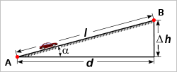
There are several systems for expressing slope:- as an angle of inclination to the horizontal. (This is the angle α opposite the "rise" side of a triangle with a right angle between vertical rise and horizontal run.)
- as a percentagePercent signThe percent sign is the symbol used to indicate a percentage .Related signs include the permille sign ‰ and the permyriad sign , which indicate that a number is divided by one thousand or ten thousand respectively...
, the formula for which is which could also be expressed as the tangent of the angle of inclination times 100. In the U.S., this percentage "grade" is the most commonly used unit for communicating slopes in transportation (streetStreetA street is a paved public thoroughfare in a built environment. It is a public parcel of land adjoining buildings in an urban context, on which people may freely assemble, interact, and move about. A street can be as simple as a level patch of dirt, but is more often paved with a hard, durable...
s, roadRoadA road is a thoroughfare, route, or way on land between two places, which typically has been paved or otherwise improved to allow travel by some conveyance, including a horse, cart, or motor vehicle. Roads consist of one, or sometimes two, roadways each with one or more lanes and also any...
s, highwayHighwayA highway is any public road. In American English, the term is common and almost always designates major roads. In British English, the term designates any road open to the public. Any interconnected set of highways can be variously referred to as a "highway system", a "highway network", or a...
s and rail tracks), surveying, construction, and civil engineering. - as a per mille figure, the formula for which is
 which could also be expressed as the tangent of the angle of inclination times 1000. This is commonly used in Europe to denote the incline of a railway.
 - as a ratio of one part rise to so many parts run. For example, a slope that has a rise of 5 feet for every 100 feet of run would have a slope ratio of 1 in 20. (The word "in" is normally used rather than the mathematical ratio notation of "1:20"). This is generally the method used to describe railway grades in Australia and the UK.
Any one of these expressions may be used interchangeably to express the characteristics of a slope. Grade is usually expressed as a percentage, but this may easily be converted to the angle α from horizontal since that carries the same information.
There is a method in which slope may be expressed when the horizontal run is not known: rise divided by the hypotenuse
Hypotenuse
In geometry, a hypotenuse is the longest side of a right-angled triangle, the side opposite the right angle. The length of the hypotenuse of a right triangle can be found using the Pythagorean theorem, which states that the square of the length of the hypotenuse equals the sum of the squares of the...
(the slope length). This is not a usual way to measure slope. This follows the sine
Sine
In mathematics, the sine function is a function of an angle. In a right triangle, sine gives the ratio of the length of the side opposite to an angle to the length of the hypotenuse.Sine is usually listed first amongst the trigonometric functions....
function rather than the tangent function and this method diverges from the "rise over run" method as angles start getting larger (see small-angle formula).
Many of the mathematical principles of slope that follow from the definition are applicable in topographic practice. In the UK, for road signs
Traffic sign
Traffic signs or road signs are signs erected at the side of roads to provide information to road users. With traffic volumes increasing over the last eight decades, many countries have adopted pictorial signs or otherwise simplified and standardized their signs to facilitate international travel...
, maps and construction work, the gradient was traditionally expressed as a ratio such as 1 in 12, but signs showing gradient expressed as a percentage are becoming more common.
In civil engineering
Civil engineering
Civil engineering is a professional engineering discipline that deals with the design, construction, and maintenance of the physical and naturally built environment, including works like roads, bridges, canals, dams, and buildings...
applications and physical geography, the slope is calculated along a particular direction of interest which is normally the route of a highway or railway road bed.
Mathematical equations
Grades can be related using the following equations with symbols from the figure at top.Tangent as a ratio:

This ratio can also be expressed as a percentage by multiplying by 100.
Angle from a tangent gradient:

If the tangent is expressed as a percentage, the angle can be determined as:

If the angle is expressed as a ratio (1 in n) then:

Roads
In vehicularVehicle
A vehicle is a device that is designed or used to transport people or cargo. Most often vehicles are manufactured, such as bicycles, cars, motorcycles, trains, ships, boats, and aircraft....
engineering
Engineering
Engineering is the discipline, art, skill and profession of acquiring and applying scientific, mathematical, economic, social, and practical knowledge, in order to design and build structures, machines, devices, systems, materials and processes that safely realize improvements to the lives of...
, various land
Landform
A landform or physical feature in the earth sciences and geology sub-fields, comprises a geomorphological unit, and is largely defined by its surface form and location in the landscape, as part of the terrain, and as such, is typically an element of topography...
-based designs (cars
Automobile
An automobile, autocar, motor car or car is a wheeled motor vehicle used for transporting passengers, which also carries its own engine or motor...
, SUVs, truck
Truck
A truck or lorry is a motor vehicle designed to transport cargo. Trucks vary greatly in size, power, and configuration, with the smallest being mechanically similar to an automobile...
s, train
Train
A train is a connected series of vehicles for rail transport that move along a track to transport cargo or passengers from one place to another place. The track usually consists of two rails, but might also be a monorail or maglev guideway.Propulsion for the train is provided by a separate...
s, etc.) are rated for their ability to ascend terrain
Terrain
Terrain, or land relief, is the vertical and horizontal dimension of land surface. When relief is described underwater, the term bathymetry is used...
. (Trains typically rate much lower than cars.) The highest grade a vehicle can ascend while maintaining a particular speed is sometimes termed that vehicle's "gradeability" (or, less often, "grade ability"). The lateral slopes of a highway geometry are sometimes called fills
Embankment (transportation)
To keep a road or railway line straight or flat, and where the comparative cost or practicality of alternate solutions is prohibitive, the land over which the road or rail line will travel is built up to form an embankment. An embankment is therefore in some sense the opposite of a cutting, and...
or cuts
Cut (earthmoving)
In civil engineering, a cut or cutting is where soil or rock material from a hill or mountain is cut out to make way for a canal, road or railway line....
where these techniques have been used to create them.
Environmental design
Grade, pitch, and slope are important components in landscape designLandscape design
Landscape design is an independent profession and a design and art tradition, practised by landscape designers, combining nature and culture. In contemporary practice landscape design bridges between landscape architecture and garden design.-Design scope:...
, garden design
Garden design
Garden design is the art and process of designing and creating plans for layout and planting of gardens and landscapes. Garden design may be done by the garden owner themselves, or by professionals of varying levels of experience and expertise...
, landscape architecture
Landscape architecture
Landscape architecture is the design of outdoor and public spaces to achieve environmental, socio-behavioral, or aesthetic outcomes. It involves the systematic investigation of existing social, ecological, and geological conditions and processes in the landscape, and the design of interventions...
, and architecture
Architecture
Architecture is both the process and product of planning, designing and construction. Architectural works, in the material form of buildings, are often perceived as cultural and political symbols and as works of art...
; for engineering and aesthetic design factors. Drainage, slope stability, circulation of people and vehicles, complying with building codes, and design integration are aspects of slope considerations in environmental design
Environmental design
Environmental design is the process of addressing surrounding environmental parameters when devising plans, programs, policies, buildings, or products...
.
Railways
Gradients limit the load that a locomotiveLocomotive
A locomotive is a railway vehicle that provides the motive power for a train. The word originates from the Latin loco – "from a place", ablative of locus, "place" + Medieval Latin motivus, "causing motion", and is a shortened form of the term locomotive engine, first used in the early 19th...
can haul, including the weight of the locomotive itself. On a 1% gradient (1 in 100) a locomotive can pull half (or less) of the load that it can pull on level track. (A heavily loaded train rolling at 20 km/hr on heavy rail may require ten times the pull on a 1% upgrade that it does on the level at that speed.) Early railways in the United Kingdom
United Kingdom
The United Kingdom of Great Britain and Northern IrelandIn the United Kingdom and Dependencies, other languages have been officially recognised as legitimate autochthonous languages under the European Charter for Regional or Minority Languages...
were laid out with very gentle gradients, such as 0.05% (1 in 2000), because the early locomotives (and their brakes) were so feeble. Steep gradients were concentrated in short sections of lines where it was convenient to employ assistant engines
Bank engine
A bank engine or helper engine or pusher engine is a railway locomotive that temporarily assists a train that requires additional power or traction to climb a grade...
or cable haulage
Cable railway
A cable railway is a steeply graded railway that uses a cable or rope to haul trains.-Introduction:...
, such as from Euston
Euston railway station
Euston railway station, also known as London Euston, is a central London railway terminus in the London Borough of Camden. It is the sixth busiest rail terminal in London . It is one of 18 railway stations managed by Network Rail, and is the southern terminus of the West Coast Main Line...
to Camden Town
Camden Town
-Economy:In recent years, entertainment-related businesses and a Holiday Inn have moved into the area. A number of retail and food chain outlets have replaced independent shops driven out by high rents and redevelopment. Restaurants have thrived, with the variety of culinary traditions found in...
, about 1.2 km. Extremely steep gradients need the help of cables, or some kind of rack railway
Rack railway
A rack-and-pinion railway is a railway with a toothed rack rail, usually between the running rails. The trains are fitted with one or more cog wheels or pinions that mesh with this rack rail...
.
Gradients can be expressed as W feet per mile, X feet per chain, 1 in Y, and Z%. Since surveyors like round figures, the method of express can affect the gradients selected.
The steepest railway lines
Rail adhesion
The term adhesion railway or adhesion traction describes the most common type of railway, where power is applied by driving some or all of the wheels of the locomotive. Thus, it relies on the friction between a steel wheel and a steel rail. Note that steam locomotives of old were driven only by...
that do not utilize a rack system include:
- 13.5 % - Lisbon tramTrams in LisbonThe Lisbon tramway network serves the municipality of Lisbon, capital city of Portugal. In operation since 1873, it presently comprises five urban lines, and is primarily a tourist attraction.-History:...
, PortugalPortugalPortugal , officially the Portuguese Republic is a country situated in southwestern Europe on the Iberian Peninsula. Portugal is the westernmost country of Europe, and is bordered by the Atlantic Ocean to the West and South and by Spain to the North and East. The Atlantic archipelagos of the... - 11.6 % - PöstlingbergbahnPöstlingbergbahnThe Pöstlingbergbahn is a narrow-gauge electric railway, or "mountain tramway", in Linz, Austria. It connects the main square in the center of Linz with the district of Pöstlingberg, located at the top of a hill at the northern end of the city...
, LinzLinzLinz is the third-largest city of Austria and capital of the state of Upper Austria . It is located in the north centre of Austria, approximately south of the Czech border, on both sides of the river Danube. The population of the city is , and that of the Greater Linz conurbation is about...
, AustriaAustriaAustria , officially the Republic of Austria , is a landlocked country of roughly 8.4 million people in Central Europe. It is bordered by the Czech Republic and Germany to the north, Slovakia and Hungary to the east, Slovenia and Italy to the south, and Switzerland and Liechtenstein to the... - 11 % Cass Scenic Railway USA (former logging line)
- 9.0 % - Ligne de Saint Gervais - Vallorcine, FranceFranceThe French Republic , The French Republic , The French Republic , (commonly known as France , is a unitary semi-presidential republic in Western Europe with several overseas territories and islands located on other continents and in the Indian, Pacific, and Atlantic oceans. Metropolitan France...
- 7.1 % - Erzberg Railway, AustriaAustriaAustria , officially the Republic of Austria , is a landlocked country of roughly 8.4 million people in Central Europe. It is bordered by the Czech Republic and Germany to the north, Slovakia and Hungary to the east, Slovenia and Italy to the south, and Switzerland and Liechtenstein to the...
- 7% - Bernina RailwayBernina RailwayThe Bernina Railway is a single track metre gauge railway line forming part of the Rhaetian Railway . It links the spa resort of St. Moritz, in the Canton of Graubünden, Switzerland, with the town of Tirano, in the Province of Sondrio, Italy, via the Bernina Pass...
, SwitzerlandSwitzerlandSwitzerland name of one of the Swiss cantons. ; ; ; or ), in its full name the Swiss Confederation , is a federal republic consisting of 26 cantons, with Bern as the seat of the federal authorities. The country is situated in Western Europe,Or Central Europe depending on the definition.... - 6.0% (1 in 16.6) - Docklands Light RailwayDocklands Light RailwayThe Docklands Light Railway is an automated light metro or light rail system opened on 31 August 1987 to serve the redeveloped Docklands area of London...
, LondonLondonLondon is the capital city of :England and the :United Kingdom, the largest metropolitan area in the United Kingdom, and the largest urban zone in the European Union by most measures. Located on the River Thames, London has been a major settlement for two millennia, its history going back to its...
, UK - 5.6% (1 in 18) - FlåmFlåmFlåm is a village at the inner end of the Aurlandsfjord, an arm of the Sognefjord. The village is located in the municipality of Aurland in Sogn og Fjordane county, Norway...
, NorwayNorwayNorway , officially the Kingdom of Norway, is a Nordic unitary constitutional monarchy whose territory comprises the western portion of the Scandinavian Peninsula, Jan Mayen, and the Arctic archipelago of Svalbard and Bouvet Island. Norway has a total area of and a population of about 4.9 million... - 5.1% (1 in 19.6) - Saluda GradeSaluda GradeSaluda Grade is the steepest standard-gauge mainline railway grade in the United States. Owned by the Norfolk Southern Railway as part of its W Line, the Saluda Grade in Polk County, North Carolina consists of a three-mile section of track that rises over in elevation with a highest official...
, North CarolinaNorth CarolinaNorth Carolina is a state located in the southeastern United States. The state borders South Carolina and Georgia to the south, Tennessee to the west and Virginia to the north. North Carolina contains 100 counties. Its capital is Raleigh, and its largest city is Charlotte...
, United StatesUnited StatesThe United States of America is a federal constitutional republic comprising fifty states and a federal district... - 5.0% (1 in 20) - Khyber Pass Railway, PakistanPakistanPakistan , officially the Islamic Republic of Pakistan is a sovereign state in South Asia. It has a coastline along the Arabian Sea and the Gulf of Oman in the south and is bordered by Afghanistan and Iran in the west, India in the east and China in the far northeast. In the north, Tajikistan...
- 4.0% (1 in 25) - Cologne-Frankfurt high-speed rail line
- 4.0% (1 in 25) - Bolan Pass Railway, PakistanPakistanPakistan , officially the Islamic Republic of Pakistan is a sovereign state in South Asia. It has a coastline along the Arabian Sea and the Gulf of Oman in the south and is bordered by Afghanistan and Iran in the west, India in the east and China in the far northeast. In the north, Tajikistan...
- 4.0% (1 in 25) (211.2 feet per mile) - Tarana - Oberon branch, New South WalesNew South WalesNew South Wales is a state of :Australia, located in the east of the country. It is bordered by Queensland, Victoria and South Australia to the north, south and west respectively. To the east, the state is bordered by the Tasman Sea, which forms part of the Pacific Ocean. New South Wales...
, AustraliaAustraliaAustralia , officially the Commonwealth of Australia, is a country in the Southern Hemisphere comprising the mainland of the Australian continent, the island of Tasmania, and numerous smaller islands in the Indian and Pacific Oceans. It is the world's sixth-largest country by total area...
. - 4.0% (1 in 25) - Matheran Light Railway, India
- 3.7% (1 in 27) - Ecclesbourne Valley RailwayEcclesbourne Valley RailwayThe Ecclesbourne Valley Railway is a long heritage railway in Derbyshire, the headquarters of the railway centre around Wirksworth station and services operate between Wirksworth and Duffield and Wirksworth and Ravenstor...
, Heritage Line, WirksworthWirksworthWirksworth is a small market town in Derbyshire, England, with a population of over 9,000.The population of the Wirksworth area including Cromford, Bolehill and Middleton-by-Wirksworth is about 12,000. Wirksworth is listed in the Domesday Book in 1086. Within it is the source of the River...
, DerbyshireDerbyshireDerbyshire is a county in the East Midlands of England. A substantial portion of the Peak District National Park lies within Derbyshire. The northern part of Derbyshire overlaps with the Pennines, a famous chain of hills and mountains. The county contains within its boundary of approx...
, UK - 1.66% (1 in 60) RudgwickRudgwick railway stationRudgwick railway station was on the Cranleigh Line. It opened in November 1865, one month after the rest of the stations on the line, due to objections made by the Board of Trade's Colonel Yolland following the obligatory inspection of the line on 2 May in that year.The Colonel objected to the...
platform with non-continuous brakes - too steep. - 1.51% (1 in 66) ( foot per chain) New South Wales Railways, part of South line.
- 0.77% (1 in 130) RudgwickRudgwick railway stationRudgwick railway station was on the Cranleigh Line. It opened in November 1865, one month after the rest of the stations on the line, due to objections made by the Board of Trade's Colonel Yolland following the obligatory inspection of the line on 2 May in that year.The Colonel objected to the...
platform with non-continuous brakes - not too steep.
It is customary for civil engineers to refer to the steepest grade on a section of rail line as the ruling grade for that section. Civil engineering works such as cuttings, embankments and tunnels are employed to reduce this maximum grade.
Compensation for curvature
Gradients on sharp curves are effectively a bit steeper than the same gradient on straight track, so to "compensate" for this and make the ruling grade uniform throughout, the gradient on those sharp curves should be reduced slightly.Continuous brakes
In the era before continuous brakes, whether air brakeAir brake
Air brake may refer to the following contexts:* Air brake , in aeronautics, a type of flight control system used on aircraft to reduce speed...
or vacuum brakes steep gradients were a serious problem making it difficult to stop on the grade safely. In an extreme example, the Inspector insisted that a station
Rudgwick railway station
Rudgwick railway station was on the Cranleigh Line. It opened in November 1865, one month after the rest of the stations on the line, due to objections made by the Board of Trade's Colonel Yolland following the obligatory inspection of the line on 2 May in that year.The Colonel objected to the...
be regraded before he would allow it to open. This required the gradient through the platform to be eased from 1 in 80 to 1 in 130.
Effects of grade
The greater a grade, the more power an animal or a machine requires to climb it at a given speed; therefore routes with lower grades are preferred, so long as they do not have other disadvantages, such as causing the overall travel distance to increase significantly.Vehicles proceeding up a steep grade demand more fuel consumption with typically increased air pollution generation. Sound level increases are also produced by motor vehicles travelling upgrade.
See also
- Civil engineeringCivil engineeringCivil engineering is a professional engineering discipline that deals with the design, construction, and maintenance of the physical and naturally built environment, including works like roads, bridges, canals, dams, and buildings...
- Construction surveyingConstruction surveyingConstruction surveying is to stake out reference points and markers that will guide the construction of new structures such as roads or buildings...
- Cut-and-cover
- Cut and fillCut and fillIn earthmoving, cut and fill is the process of constructing a railway, road or canal whereby the amount of material from cuts roughly matches the amount of fill needed to make nearby embankments, so minimizing the amount of construction labor...
- Cut (earthmoving)Cut (earthmoving)In civil engineering, a cut or cutting is where soil or rock material from a hill or mountain is cut out to make way for a canal, road or railway line....
- Embankment (transportation)Embankment (transportation)To keep a road or railway line straight or flat, and where the comparative cost or practicality of alternate solutions is prohibitive, the land over which the road or rail line will travel is built up to form an embankment. An embankment is therefore in some sense the opposite of a cutting, and...
- Grade separationGrade separationGrade separation is the method of aligning a junction of two or more transport axes at different heights so that they will not disrupt the traffic flow on other transit routes when they cross each other. The composition of such transport axes does not have to be uniform; it can consist of a...
- Roof pitchRoof pitchIn building construction, roof pitch is a numerical measure of the steepness of a roof, and a pitched roof is a roof that is steep.The roof's pitch is the measured vertical rise divided by the measured horizontal span, the same thing as what is called "slope" in geometry. Roof pitch is typically...
- Ruling gradientRuling gradientThe term "ruling grade" is usually used as a synonym for "steepest climb" between two points on a railroad. But if the steepest climb is, say, a quarter-mile of 2% upgrade preceded and followed by 1.5% grade the "ruling grade" can only be defined arbitrarily....
- SlopeSlopeIn mathematics, the slope or gradient of a line describes its steepness, incline, or grade. A higher slope value indicates a steeper incline....
- SurveyingSurveyingSee Also: Public Land Survey SystemSurveying or land surveying is the technique, profession, and science of accurately determining the terrestrial or three-dimensional position of points and the distances and angles between them...
- TrenchTrenchA trench is a type of excavation or depression in the ground. Trenches are generally defined by being deeper than they are wide , and by being narrow compared to their length ....
- TunnelTunnelA tunnel is an underground passageway, completely enclosed except for openings for egress, commonly at each end.A tunnel may be for foot or vehicular road traffic, for rail traffic, or for a canal. Some tunnels are aqueducts to supply water for consumption or for hydroelectric stations or are sewers...