
Construction surveying
Encyclopedia
Construction surveying is to stake out reference points and markers that will guide the construction of new structures such as roads or buildings. These markers are usually staked out according to a suitable coordinate system selected for the project.
coordinates. However for the purposes of construction a more suitable coordinate system will often be used. During construction surveying, the surveyor will often have to convert from geodesic coordinates to the coordinate system used for that project.
, a chainage will be established, often to correspond with the center line of the road. During construction, structures would then be located in terms of chainage, offset and elevation. Offset is said to be "left" or "right" relative to someone standing on the chainage line who is looking in the direction of increasing chainage. Plans would often show plan views (viewed from above), profile views (a "transparent" section view collapsing all section views of the road parallel to the chainage) or cross-section views (a "true" section view perpendicular to the chainage). In a plan view, chainage generally increases from left to right, or from the bottom to the top of the plan. Profiles are shown with the chainage increasing from left to right, and cross-sections are shown as if the viewer is looking in the direction of increasing chainage (so that the "left" offset is to the left and the "right" offset is to the right).
"Chainage" may also be referred to as "Station".
s, are used for accurate measurement of angular deviation, horizontal, vertical and slope distances. With computerisation, electronic distance measurement (EDM)
, total station
s, GPS surveying and laser scanning have supplemented (and to a large extent supplanted) the traditional optical instruments.
The builder's level measures neither horizontal nor vertical angles. It simply combines a spirit level and telescope to allow the user to visually establish a line of sight along a level plane. When used together with a graduated staff it can be used to transfer elevations from one location to another. An alternative method to transfer elevation is to use water in a transparent hose as the level of the water in the hose at opposite ends will be at the same elevation.
surveying.
), ceilings (backs), and floors as the drifts of an underground mine are driven. The recorded data is then downloaded into a CAD program, and compared to the designed layout of the tunnel.
The survey party installs control stations at regular intervals. These are small steel plugs installed in pairs in holes drilled into walls or the back. For wall stations, two plugs are installed in opposite walls, forming a line perpendicular to the drift. For back stations, two plugs are installed in the back, forming a line parallel to the drift.
A set of plugs can be used to locate the total station set up in a drift or tunnel by processing measurements to the plugs by intersection and resection
.
by a group of technically minded General Practice Surveyors. Building Surveying is a recognized profession within Britain and Australia
. In Australia in particular, due to risk mitigation/limitation factors the employment of surveyors at all levels of the construction industry is widespread. There are still many countries where it is not widely recognized as a profession. The Services that Building Surveyors undertake are broad but include:
Building Surveyors also advise on many aspects of construction including:
Clients of a building surveyor can be the public sector, Local Authorities, Government Departments as well as private sector organisations and work closely with architects, planners, homeowners and tenants groups. Building Surveyors may also be called to act as an expert witness
. It is usual for building surveyors to undertake an accredited degree qualification before undertaking structured training to become a member of a professional organisation. For Chartered Building Surveyors, these courses are accredited by the Royal Institution of Chartered Surveyors. Other professional organisations that have building surveyor members include CIOB
, ABE, HKIS and RICS.
With the enlargement of the European community, the profession of the Chartered Building Surveyor is becoming more widely known in other European states, particularly France. Chartered Building Surveyors, where many English speaking people buy second homes.
History of construction surveying
- The nearly perfect squareness and north-south orientation of the Great Pyramid of GizaGreat Pyramid of GizaThe Great Pyramid of Giza is the oldest and largest of the three pyramids in the Giza Necropolis bordering what is now El Giza, Egypt. It is the oldest of the Seven Wonders of the Ancient World, and the only one to remain largely intact...
, built c. 2700 BC, affirm the EgyptiansEgyptiansEgyptians are nation an ethnic group made up of Mediterranean North Africans, the indigenous people of Egypt.Egyptian identity is closely tied to geography. The population of Egypt is concentrated in the lower Nile Valley, the small strip of cultivable land stretching from the First Cataract to...
' command of surveying. - A recent reassessment of StonehengeStonehengeStonehenge is a prehistoric monument located in the English county of Wiltshire, about west of Amesbury and north of Salisbury. One of the most famous sites in the world, Stonehenge is composed of a circular setting of large standing stones set within earthworks...
(c.2500 BC) suggests that the monument was set out by prehistoric surveyors using peg and rope geometry. - In the sixth century BC geometric based techniques were used to construct the tunnel of Eupalinos on the island of Samos.
Elements of the construction survey
- Survey existing conditions of the future work site, including topography, existing buildings and infrastructure, and underground infrastructure whenever possible (for example, measuring invert elevations and diameters of sewers at manholes);
- Stake out reference points and markers that will guide the construction of new structures;
- Verify the location of structures during construction;
- Conduct an As-Built survey: a survey conducted at the end of the construction project to verify that the work authorized was completed to the specifications set on plans.
Coordinate systems used in construction
Land surveys and surveys of existing conditions are generally performed according to geodesicGeodesic
In mathematics, a geodesic is a generalization of the notion of a "straight line" to "curved spaces". In the presence of a Riemannian metric, geodesics are defined to be the shortest path between points in the space...
coordinates. However for the purposes of construction a more suitable coordinate system will often be used. During construction surveying, the surveyor will often have to convert from geodesic coordinates to the coordinate system used for that project.
Chainage or station
In the case of roads or other linear infrastructureInfrastructure
Infrastructure is basic physical and organizational structures needed for the operation of a society or enterprise, or the services and facilities necessary for an economy to function...
, a chainage will be established, often to correspond with the center line of the road. During construction, structures would then be located in terms of chainage, offset and elevation. Offset is said to be "left" or "right" relative to someone standing on the chainage line who is looking in the direction of increasing chainage. Plans would often show plan views (viewed from above), profile views (a "transparent" section view collapsing all section views of the road parallel to the chainage) or cross-section views (a "true" section view perpendicular to the chainage). In a plan view, chainage generally increases from left to right, or from the bottom to the top of the plan. Profiles are shown with the chainage increasing from left to right, and cross-sections are shown as if the viewer is looking in the direction of increasing chainage (so that the "left" offset is to the left and the "right" offset is to the right).
"Chainage" may also be referred to as "Station".
Building grids
In the case of buildings, an arbitrary system of grids is often established so as to correspond to the rows of columns and the major load-bearing walls of the building. The grids may be identified alphabetically in one direction, and numerically in the other direction (as in a road map). The grids are usually but not necessarily perpendicular, and are often but not necessarily evenly spaced. Floors and basement levels are also numbered. Structures, equipment or architectural details may be located in reference to the floor and the nearest intersection of the arbitrary axes.Other coordinate systems
In other types of construction projects, arbitrary "north-south" and "east-west" reference lines may be established, that do not necessarily correspond to true coordinates.Equipment and techniques used in construction surveying
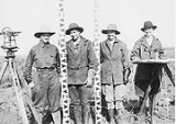
Surveying equipment, such as levels and theodoliteTheodolite
A theodolite is a precision instrument for measuring angles in the horizontal and vertical planes. Theodolites are mainly used for surveying applications, and have been adapted for specialized purposes in fields like metrology and rocket launch technology...
s, are used for accurate measurement of angular deviation, horizontal, vertical and slope distances. With computerisation, electronic distance measurement (EDM)
Total station
A total station is an electronic/optical instrument used in modern surveying. The total station is an electronic theodolite integrated with an electronic distance meter to read slope distances from the instrument to a particular point....
, total station
Total station
A total station is an electronic/optical instrument used in modern surveying. The total station is an electronic theodolite integrated with an electronic distance meter to read slope distances from the instrument to a particular point....
s, GPS surveying and laser scanning have supplemented (and to a large extent supplanted) the traditional optical instruments.
The builder's level measures neither horizontal nor vertical angles. It simply combines a spirit level and telescope to allow the user to visually establish a line of sight along a level plane. When used together with a graduated staff it can be used to transfer elevations from one location to another. An alternative method to transfer elevation is to use water in a transparent hose as the level of the water in the hose at opposite ends will be at the same elevation.
Equipment and techniques used in mining and tunneling
Total stations are the primary survey instrument used in miningMining
Mining is the extraction of valuable minerals or other geological materials from the earth, from an ore body, vein or seam. The term also includes the removal of soil. Materials recovered by mining include base metals, precious metals, iron, uranium, coal, diamonds, limestone, oil shale, rock...
surveying.
Underground mining
A total station is used to record the absolute location of the tunnel walls (stopesStoping (mining method)
Stoping is the removal of the wanted ore from an underground mine leaving behind an open space known as a stope. Stoping is used when the country rock is sufficiently strong not to cave into the stope, although in most cases artificial support is also provided...
), ceilings (backs), and floors as the drifts of an underground mine are driven. The recorded data is then downloaded into a CAD program, and compared to the designed layout of the tunnel.
The survey party installs control stations at regular intervals. These are small steel plugs installed in pairs in holes drilled into walls or the back. For wall stations, two plugs are installed in opposite walls, forming a line perpendicular to the drift. For back stations, two plugs are installed in the back, forming a line parallel to the drift.
A set of plugs can be used to locate the total station set up in a drift or tunnel by processing measurements to the plugs by intersection and resection
Resection (orientation)
Resection is a method for determining a position using a compass and topographic map .-Resection versus intersection:...
.
Professional status of construction surveyors
Building Surveying emerged in the 1970s as a profession in the United KingdomUnited Kingdom
The United Kingdom of Great Britain and Northern IrelandIn the United Kingdom and Dependencies, other languages have been officially recognised as legitimate autochthonous languages under the European Charter for Regional or Minority Languages...
by a group of technically minded General Practice Surveyors. Building Surveying is a recognized profession within Britain and Australia
Australia
Australia , officially the Commonwealth of Australia, is a country in the Southern Hemisphere comprising the mainland of the Australian continent, the island of Tasmania, and numerous smaller islands in the Indian and Pacific Oceans. It is the world's sixth-largest country by total area...
. In Australia in particular, due to risk mitigation/limitation factors the employment of surveyors at all levels of the construction industry is widespread. There are still many countries where it is not widely recognized as a profession. The Services that Building Surveyors undertake are broad but include:
- Construction design and building works
- Project Management and monitoring
- CDM Co-ordinator under the Construction (Design & Management) Regulations 2007
- Property Legislation adviser
- Insurance assessment and claims assistance
- Defect investigation and maintenance adviser
- Building Surveys and measured surveys
- Handling Planning applications
- Building Inspection to ensure compliance with building regulations
- Undertaking pre-acquisition surveys
- Negotiating dilapidations claims
Building Surveyors also advise on many aspects of construction including:
- design
- maintenance
- repair
- refurbishment
- restoration
Clients of a building surveyor can be the public sector, Local Authorities, Government Departments as well as private sector organisations and work closely with architects, planners, homeowners and tenants groups. Building Surveyors may also be called to act as an expert witness
Expert witness
An expert witness, professional witness or judicial expert is a witness, who by virtue of education, training, skill, or experience, is believed to have expertise and specialised knowledge in a particular subject beyond that of the average person, sufficient that others may officially and legally...
. It is usual for building surveyors to undertake an accredited degree qualification before undertaking structured training to become a member of a professional organisation. For Chartered Building Surveyors, these courses are accredited by the Royal Institution of Chartered Surveyors. Other professional organisations that have building surveyor members include CIOB
Chartered Institute of Building
The Chartered Institute of Building is a body that represents professionals who work within the built environment in the United Kingdom.- History :...
, ABE, HKIS and RICS.
With the enlargement of the European community, the profession of the Chartered Building Surveyor is becoming more widely known in other European states, particularly France. Chartered Building Surveyors, where many English speaking people buy second homes.
Distinction from land surveyors
In the United States, Canada, the United Kingdom and most Commonwealth countries land surveying is considered to be a distinct profession. Land surveyors have their own professional associations and licencing requirements. The services of a licenced land surveyor are generally required for boundary surveys (to establish the boundaries of a parcel using its legal description) and subdivision plans (a plot or map based on a survey of a parcel of land, with boundary lines drawn inside the larger parcel to indicated the creation of new boundary lines and roads).External links
- Surveying outline University of British Columbia, Carlos E.Ventura
- As-builts – Problems & Proposed Solutions — Discussion on Building Surveys within Construction industry by Stephen R. Pettee, CCM