

Upper Rhine Plain
Encyclopedia

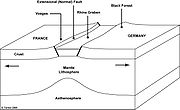
Rift
In geology, a rift or chasm is a place where the Earth's crust and lithosphere are being pulled apart and is an example of extensional tectonics....
, straddling the border between France
France
The French Republic , The French Republic , The French Republic , (commonly known as France , is a unitary semi-presidential republic in Western Europe with several overseas territories and islands located on other continents and in the Indian, Pacific, and Atlantic oceans. Metropolitan France...
and Germany
Germany
Germany , officially the Federal Republic of Germany , is a federal parliamentary republic in Europe. The country consists of 16 states while the capital and largest city is Berlin. Germany covers an area of 357,021 km2 and has a largely temperate seasonal climate...
. It forms part of the European Cenozoic Rift System
European Cenozoic Rift System
The European Cenozoic Rift System is an 1100 km long system of rifts formed in the foreland of the Alps as the lithosphere responded to the effects of the Alpine and Pyrenean orogenies...
, which extends across central Europe. The Upper Rhine Graben formed during the Oligocene
Oligocene
The Oligocene is a geologic epoch of the Paleogene Period and extends from about 34 million to 23 million years before the present . As with other older geologic periods, the rock beds that define the period are well identified but the exact dates of the start and end of the period are slightly...
as a response to the evolution of the Alps
Alps
The Alps is one of the great mountain range systems of Europe, stretching from Austria and Slovenia in the east through Italy, Switzerland, Liechtenstein and Germany to France in the west....
to the south and remains active to the present day. Today, the Rhine Rift Valley forms a downfaulted trough through which the River Rhine flows. It is bounded to the west by the Vosges mountain range in France, and to the east by the Black Forest
Black Forest
The Black Forest is a wooded mountain range in Baden-Württemberg, southwestern Germany. It is bordered by the Rhine valley to the west and south. The highest peak is the Feldberg with an elevation of 1,493 metres ....
in western Germany.
Formation

Cenozoic
The Cenozoic era is the current and most recent of the three Phanerozoic geological eras and covers the period from 65.5 mya to the present. The era began in the wake of the Cretaceous–Tertiary extinction event at the end of the Cretaceous that saw the demise of the last non-avian dinosaurs and...
era, during the Late Eocene
Eocene
The Eocene Epoch, lasting from about 56 to 34 million years ago , is a major division of the geologic timescale and the second epoch of the Paleogene Period in the Cenozoic Era. The Eocene spans the time from the end of the Palaeocene Epoch to the beginning of the Oligocene Epoch. The start of the...
epoch. At this time, the Alpine Orogeny
Alpine orogeny
The Alpine orogeny is an orogenic phase in the Late Mesozoic and Tertiary that formed the mountain ranges of the Alpide belt...
, the major mountain building event that was to produce the Alps
Alps
The Alps is one of the great mountain range systems of Europe, stretching from Austria and Slovenia in the east through Italy, Switzerland, Liechtenstein and Germany to France in the west....
, was in its early stages. The Alps were formed because the continents of Europe and Africa collided. It is thought that because the collision was irregular, the initial contact between the two continents resulted in the formation of dilational (extensional) structures in the foreland basin
Foreland basin
A foreland basin is a depression that develops adjacent and parallel to a mountain belt. Foreland basins form because the immense mass created by crustal thickening associated with the evolution of a mountain belt causes the lithosphere to bend, by a process known as lithospheric flexure...
to the north of the Alps. The result was substantial crustal thinning, forming a major extensional graben
Graben
In geology, a graben is a depressed block of land bordered by parallel faults. Graben is German for ditch. Graben is used for both the singular and plural....
and causing isolated volcanic activity. The stretch factor is estimated to be ~2.
Rift flank uplift
Black Forest
The Black Forest is a wooded mountain range in Baden-Württemberg, southwestern Germany. It is bordered by the Rhine valley to the west and south. The highest peak is the Feldberg with an elevation of 1,493 metres ....
. These ranges exhume the same types of rocks in their cores, including deep crustal gneiss
Gneiss
Gneiss is a common and widely distributed type of rock formed by high-grade regional metamorphic processes from pre-existing formations that were originally either igneous or sedimentary rocks.-Etymology:...
. Both ranges correspond to uplifts of more than 2,500 metres, much of which has since been eroded. This uplift has occurred because of the isostatic response associated with the formation of an extensional basin. As a consequence, the highest mountains exist immediately adjacent to the margin of the basin, and become increasingly low outwards. The boundaries between the hill ranges and the Rhine Graben are defined by major, normal fault zones.
Volcanic activity
The extension induced by the formation of the Alps was sufficient enough to thin the crust and provide suitable dilational conduits for magmatic and volcanic activity to occur. This resulted in the emplacement of maficMafic
Mafic is an adjective describing a silicate mineral or rock that is rich in magnesium and iron; the term is a portmanteau of the words "magnesium" and "ferric". Most mafic minerals are dark in color and the relative density is greater than 3. Common rock-forming mafic minerals include olivine,...
dykes
Dike (geology)
A dike or dyke in geology is a type of sheet intrusion referring to any geologic body that cuts discordantly across* planar wall rock structures, such as bedding or foliation...
, which follow the general structural trend of the extensional faults. In addition, isolated volcanoes such as the Kaiserstuhl were formed.
The Kaiserstuhl volcano
The KaiserstuhlKaiserstuhl
The „Kaiserstuhl“ is a relatively low mountain range – a Mittelgebirge – with a maximal height of 556.6 m above sea level. It is of volcanic origin and located in the South West of Baden-Württemberg, Germany in the districts of Emmendingen and Breisgau-Hochschwarzwald...
(literally "Emperor's Chair") is a cluster of volcanic hills to the northwest of Freiburg, within the Rhine Graben. The highest point of this small, isolated volcanic centre is the Totenkopf (557 metres). Volcanic activity was most prevalent in the Miocene
Miocene
The Miocene is a geological epoch of the Neogene Period and extends from about . The Miocene was named by Sir Charles Lyell. Its name comes from the Greek words and and means "less recent" because it has 18% fewer modern sea invertebrates than the Pliocene. The Miocene follows the Oligocene...
epoch, some 15 million years ago. Today, the Kaiserstuhl volcano is extinct.
Seismic activity
In 1356, the Basel earthquake occurred in the Rhine Plain. It was perhaps the most destructive earthquake ever to have occurred in northwest Europe, destroying the city of BaselBasel
Basel or Basle In the national languages of Switzerland the city is also known as Bâle , Basilea and Basilea is Switzerland's third most populous city with about 166,000 inhabitants. Located where the Swiss, French and German borders meet, Basel also has suburbs in France and Germany...
and flattening buildings as far as 200 km away. The epicentre of the most significant historic seismological event to have occurred in Central Europe, was located between Waldkirch
Waldkirch
Waldkirch is a town in Baden-Württemberg, Germany. It is known as "the place of mechanical organs", where fairground organs are manufactured and played on the streets from well-known manufacturers, such as A. Ruth and Sohn, Bruder and Carl Frei .-Sights:* The Catholic Church St...
and St. Peter
Sankt Peter, Baden-Württemberg
Sankt Peter is a town in the district of Breisgau-Hochschwarzwald in Baden-Württemberg in Germany.-External links:...
in Breisgau-Hochschwarzwald
Breisgau-Hochschwarzwald
Breisgau-Hochschwarzwald is a district in the south of Baden-Württemberg, Germany. Neighboring districts are Emmendingen, Schwarzwald-Baar, Waldshut, Lörrach and the French départements of the Haut-Rhin and the Bas-Rhin. The district-free city of Freiburg is surrounded by the district...
. However, it remains disputed whether the fault that ruptured to cause this earthquake was indeed part of the Rhine Valley extensional system, or simply one of the many thrust faults that make up the Alps
Alps
The Alps is one of the great mountain range systems of Europe, stretching from Austria and Slovenia in the east through Italy, Switzerland, Liechtenstein and Germany to France in the west....
to the south. Doubts have been raised over the adequacy of the seismic evaluation and design of the Fessenheim Nuclear Power Plant
Fessenheim Nuclear Power Plant
The Fessenheim Nuclear Power Plant is located in the Fessenheim commune in the Haut-Rhin department in Alsace in north-eastern France, north east of the Mulhouse urban area, within of the border with Germany, and approximately from Switzerland...
, built in the Rhine Plain close to the faults.
Upper Rhine aquifer
Located below the plain, the Upper Rhine aquiferAquifer
An aquifer is a wet underground layer of water-bearing permeable rock or unconsolidated materials from which groundwater can be usefully extracted using a water well. The study of water flow in aquifers and the characterization of aquifers is called hydrogeology...
- one of the largest in Europe - holds an estimated 450000 km³ (107,960.7 cu mi) of fresh water and supplies some 3 million people in France and Germany, supplying 75% of their drinking water and 50% of the water used by industry. Since the 1970s it has suffered increasingly serious pollution from nitrate
Nitrate
The nitrate ion is a polyatomic ion with the molecular formula NO and a molecular mass of 62.0049 g/mol. It is the conjugate base of nitric acid, consisting of one central nitrogen atom surrounded by three identically-bonded oxygen atoms in a trigonal planar arrangement. The nitrate ion carries a...
s, pesticide
Pesticide
Pesticides are substances or mixture of substances intended for preventing, destroying, repelling or mitigating any pest.A pesticide may be a chemical unicycle, biological agent , antimicrobial, disinfectant or device used against any pest...
s, chloride
Chloride
The chloride ion is formed when the element chlorine, a halogen, picks up one electron to form an anion Cl−. The salts of hydrochloric acid HCl contain chloride ions and can also be called chlorides. The chloride ion, and its salts such as sodium chloride, are very soluble in water...
and VOCs
Volatile organic compound
Volatile organic compounds are organic chemicals that have a high vapor pressure at ordinary, room-temperature conditions. Their high vapor pressure results from a low boiling point, which causes large numbers of molecules to evaporate or sublimate from the liquid or solid form of the compound and...
.
Research
A collaboration of 25 universities and government agencies have been researching seismic hazards, neotectonics, and water management of the Quaternary Graben fill. The research focuses on four themes http://comp1.geol.unibas.ch/index.php?option=com_frontpage&Itemid=1:- "NeotectonicsNeotectonicsNeotectonics is a subdiscipline of tectonics. It is the study of the motions and deformations of the Earth's crust which are current or recent in geologic time. The term may also refer to the motions/deformations in question themselves. The corresponding time frame is referred to as the...
and Seismic Hazard (Identification of zones of on-going deformation. Present stress regime. Earthquake location & frequency. Hazard assessment.)" - "Modeling of Hydro systems (Modeling of Plio-Quaternary hydro systems of the Upper Rhine Graben and of transfer time of pollutants within them)"
- "Structure and Evolution (Reassessment of structural evolution of the Upper Rhine Graben and implications for its neotectonic deformation; Fault reactivation, crustal rheology and earthquake activity)"
- "Dynamic Modeling (Multi scale dynamic modeling of the past and present deformation of the Rhine Graben area)"