
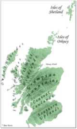
Central Lowlands
Encyclopedia
_named_(hr).png)
Scotland
Scotland is a country that is part of the United Kingdom. Occupying the northern third of the island of Great Britain, it shares a border with England to the south and is bounded by the North Sea to the east, the Atlantic Ocean to the north and west, and the North Channel and Irish Sea to the...
. It consists of a rift valley
Rift valley
A rift valley is a linear-shaped lowland between highlands or mountain ranges created by the action of a geologic rift or fault. This action is manifest as crustal extension, a spreading apart of the surface which is subsequently further deepened by the forces of erosion...
between the Highland Boundary Fault
Highland Boundary Fault
The Highland Boundary Fault is a geological fault that traverses Scotland from Arran and Helensburgh on the west coast to Stonehaven in the east...
to the north and the Southern Uplands Fault
Southern Uplands Fault
The Southern Uplands Fault is a fault in Scotland that runs from Girvan to Dunbar on the East coast. It marks the southern boundary of the Scottish Midland Valley....
to the south. The Central Lowlands are one of the three main geographical sub-divisions of Scotland, the other two being the Highlands and Islands
Highlands and Islands
The Highlands and Islands of Scotland are broadly the Scottish Highlands plus Orkney, Shetland and the Hebrides.The Highlands and Islands are sometimes defined as the area to which the Crofters' Act of 1886 applied...
which lie to the north, northwest and the Southern Uplands
Southern Uplands
The Southern Uplands are the southernmost and least populous of mainland Scotland's three major geographic areas . The term is used both to describe the geographical region and to collectively denote the various ranges of hills within this region...
, which lie south of the associated second fault line.
Boundary faults
The Highland Boundary Fault, runs from LochranzaLochranza
Lochranza is a village located on the Isle of Arran in the Firth of Clyde, Scotland. The population, somewhat in decline, is around 200 people....
on the Isle of Arran
Isle of Arran
Arran or the Isle of Arran is the largest island in the Firth of Clyde, Scotland, and with an area of is the seventh largest Scottish island. It is in the unitary council area of North Ayrshire and the 2001 census had a resident population of 5,058...
in the south and west through the Isle of Bute
Isle of Bute
Bute is an island in the Firth of Clyde in Scotland. Formerly part of the county of Buteshire, it now constitutes part of the council area of Argyll and Bute. Its resident population was 7,228 in April 2001.-Geography:...
and Helensburgh
Helensburgh
Helensburgh is a town in Argyll and Bute, Scotland. It lies on the north shore of the Firth of Clyde and the eastern shore of the entrance to the Gareloch....
, then forms the northern boundary of Strathmore
Strathmore, Angus and Perth & Kinross
Strathmore is a strath in east central Scotland running from northeast to southwest between the Grampian mountains and the Sidlaws....
before reaching Stonehaven
Stonehaven
Stonehaven is a town in Aberdeenshire, Scotland. It lies on Scotland's northeast coast and had a population of 9,577 in 2001 census.Stonehaven, county town of Kincardineshire, grew around an Iron Age fishing village, now the "Auld Toon" , and expanded inland from the seaside...
in the north east. The fault
Geologic fault
In geology, a fault is a planar fracture or discontinuity in a volume of rock, across which there has been significant displacement along the fractures as a result of earth movement. Large faults within the Earth's crust result from the action of tectonic forces...
was active during the Caledonian orogeny
Caledonian orogeny
The Caledonian orogeny is a mountain building era recorded in the northern parts of the British Isles, the Scandinavian Mountains, Svalbard, eastern Greenland and parts of north-central Europe. The Caledonian orogeny encompasses events that occurred from the Ordovician to Early Devonian, roughly...
, a plate tectonic
Plate tectonics
Plate tectonics is a scientific theory that describes the large scale motions of Earth's lithosphere...
collision which took place from Mid Ordovician
Ordovician
The Ordovician is a geologic period and system, the second of six of the Paleozoic Era, and covers the time between 488.3±1.7 to 443.7±1.5 million years ago . It follows the Cambrian Period and is followed by the Silurian Period...
to Mid Devonian
Devonian
The Devonian is a geologic period and system of the Paleozoic Era spanning from the end of the Silurian Period, about 416.0 ± 2.8 Mya , to the beginning of the Carboniferous Period, about 359.2 ± 2.5 Mya...
periods (520 to 400 million years ago), during the closure of the Iapetus Ocean
Iapetus Ocean
The Iapetus Ocean was an ocean that existed in the Neoproterozoic and Paleozoic eras of the geologic timescale . The Iapetus Ocean was situated in the southern hemisphere, between the paleocontinents of Laurentia, Baltica and Avalonia...
. The fault allowed the Midland Valley to descend as a major rift by as much as 4000 metres and there was subsequently vertical movement. This earlier vertical movement was later replaced by a horizontal shear.
The Southern Uplands Fault runs from the Rhinns of Galloway in the west towards Dunbar
Dunbar
Dunbar is a town in East Lothian on the southeast coast of Scotland, approximately 28 miles east of Edinburgh and 28 miles from the English Border at Berwick-upon-Tweed....
on the east coast 30 miles from Edinburgh
Edinburgh
Edinburgh is the capital city of Scotland, the second largest city in Scotland, and the eighth most populous in the United Kingdom. The City of Edinburgh Council governs one of Scotland's 32 local government council areas. The council area includes urban Edinburgh and a rural area...
.
Geology and geomorphology
Paleozoic
The Paleozoic era is the earliest of three geologic eras of the Phanerozoic eon, spanning from roughly...
formations. Many of these sediments have economic significance for it is here that the coal and iron bearing rocks that fuelled Scotland's industrial revolution
Industrial Revolution
The Industrial Revolution was a period from the 18th to the 19th century where major changes in agriculture, manufacturing, mining, transportation, and technology had a profound effect on the social, economic and cultural conditions of the times...
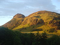
are to be found. This area has also experienced intense volcanism
Volcano
2. Bedrock3. Conduit 4. Base5. Sill6. Dike7. Layers of ash emitted by the volcano8. Flank| 9. Layers of lava emitted by the volcano10. Throat11. Parasitic cone12. Lava flow13. Vent14. Crater15...
, Arthur’s Seat
Arthur's Seat, Edinburgh
Arthur's Seat is the main peak of the group of hills which form most of Holyrood Park, described by Robert Louis Stevenson as "a hill for magnitude, a mountain in virtue of its bold design". It is situated in the centre of the city of Edinburgh, about a mile to the east of Edinburgh Castle...
in Edinburgh
Edinburgh
Edinburgh is the capital city of Scotland, the second largest city in Scotland, and the eighth most populous in the United Kingdom. The City of Edinburgh Council governs one of Scotland's 32 local government council areas. The council area includes urban Edinburgh and a rural area...
being the remnant of a once much larger volcano
Volcano
2. Bedrock3. Conduit 4. Base5. Sill6. Dike7. Layers of ash emitted by the volcano8. Flank| 9. Layers of lava emitted by the volcano10. Throat11. Parasitic cone12. Lava flow13. Vent14. Crater15...
active in the Carboniferous
Carboniferous
The Carboniferous is a geologic period and system that extends from the end of the Devonian Period, about 359.2 ± 2.5 Mya , to the beginning of the Permian Period, about 299.0 ± 0.8 Mya . The name is derived from the Latin word for coal, carbo. Carboniferous means "coal-bearing"...
period some 300 million years ago. This area is relatively low-lying, although even here hills such as the Ochils
Ochil Hills
The Ochil Hills is a range of hills in Scotland north of the Forth valley bordered by the towns of Stirling, Alloa, Kinross and Perth. The only major roads crossing the hills pass through Glen Devon/Glen Eagles and Glenfarg, the latter now largely replaced except for local traffic by the M90...
and Campsie Fells
Campsie Fells
The Campsie Fells are a range of hills in central Scotland, stretching east to west, from Denny Muir to Dumgoyne, in Stirlingshire. . The highest point in the range is Earl's Seat which is 578 m high...
are rarely far from view. In common with the rest of Scotland the whole region was affected by Pleistocene
Pleistocene
The Pleistocene is the epoch from 2,588,000 to 11,700 years BP that spans the world's recent period of repeated glaciations. The name pleistocene is derived from the Greek and ....
glaciations.
Human geography
A productive combination of fertile low-lying agricultural land and significant deposits of economically valuable coal and iron have led to the Central Lowlands being much more densely populated than the rest of Scotland. The major cities of GlasgowGlasgow
Glasgow is the largest city in Scotland and third most populous in the United Kingdom. The city is situated on the River Clyde in the country's west central lowlands...
, Edinburgh
Edinburgh
Edinburgh is the capital city of Scotland, the second largest city in Scotland, and the eighth most populous in the United Kingdom. The City of Edinburgh Council governs one of Scotland's 32 local government council areas. The council area includes urban Edinburgh and a rural area...
, Stirling
Stirling
Stirling is a city and former ancient burgh in Scotland, and is at the heart of the wider Stirling council area. The city is clustered around a large fortress and medieval old-town beside the River Forth...
and Dundee
Dundee
Dundee is the fourth-largest city in Scotland and the 39th most populous settlement in the United Kingdom. It lies within the eastern central Lowlands on the north bank of the Firth of Tay, which feeds into the North Sea...
all lie in the Central Lowlands, and over half of Scotland's population lives in this region.
See also
- Geology of ScotlandGeology of ScotlandThe geology of Scotland is unusually varied for a country of its size, with a large number of differing geological features. There are three main geographical sub-divisions: the Highlands and Islands is a diverse area which lies to the north and west of the Highland Boundary Fault; the Central...
- Central BeltCentral BeltThe Central Belt of Scotland is a common term used to describe the area of highest population density within Scotland. Despite the name, it is not geographically central but is nevertheless situated at the 'waist' of Scotland on a conventional map and the term 'central' is used in many local...
- Central Scotland (disambiguation)
- Scottish LowlandsScottish LowlandsThe Scottish Lowlands is a name given to the Southern half of Scotland.The area is called a' Ghalldachd in Scottish Gaelic, and the Lawlands ....