

Gerakas
Encyclopedia
Gerakas is a town and a former municipality in East Attica
, Greece
. Since the 2011 local government reform it is part of the municipality Pallini
, of which it is the seat and a municipal unit.
In antiquity
Gerakas constituted Attica
's deme
of Gargittos of the Aegides tribe that was located at the mesogea land, according to the administrative model of Cleisthenes
.
Today, it is a rapidly developing city of the northern mesogea and the eastern gate to the Athens basin. It is known as the birthplace of the famous philosopher Epicurus
.
The city is set at a significant place at the junction of Ymittos
and Penteli foothills. The limits of Gerakas expand from Stavros
up to the Koufos and Desi Hills, 12 km northeast of Athens and just 2 km west of Pallini
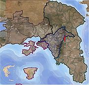
. The city has a population of 13,990 residents (in 2001), covering a land area of 11 km2 and having a density of 1,265 residents per km2. Gerakas can be seen at an elevation of 190 to 374 metres, giving the area both flat and mountainous characteristics. Due to rapid growth during the last years, Gerakas has a calculated population of 30.000 residents and a density of 2.727 residents per km2, according to municipal estimates.
–Laurium
highway that passed through, descending from Northern Greece, mostly Arvanites
from Ipiros sent to the Masogean plain at around 1205 a. C. as mercenaries to protect the Duchy of Athens
. On the northern part of the city islanders from the Aegean Sea
came to work at the world famous marble workshops of Penteli. Until the late 70s, most of the land was covered by farmhouses that constitute a Paiania
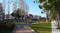
n settlement, while in 1980 it was recognized as a new commune of East Attica. The name of the commune arises after an informal referendum among the three settlements of "Gerakas", "Stavros" and "Gargittos". The center of the city is located around the Mekedonias Square, northern of Marathonos Avenue, which is a meeting place for all residents and visitors, a true adornment, whereas St. John is the patron saint of Gerakas. The main shopping district runs along the Marathonos Avenue, where the industrial and business activity is located.
 The first name that is associated with the region is "Gargittos", a name which one may come across various ancient scripts and indicate the southern foothills of Penteli. According to Greek historians, Gargittos was a local hero of the region who inhabited Attica after moving from Peloponesse during the Peloponnesian Wars, descending from Asia alongside with the Lydia
n Pelops
. According to the hιstorian Paysanias
, Gargittos was the son of Ion
.
During the middle ages
, the region is called "Karyttos", as viewed by the foreign cartographers' work. It is a region of great religious activity, where the Saint Nikolaos Church is preserved at Patima, which Saint Timotheos used as a place for asceticism until the Penteli Monastery was finished.
The modern name of "Gerakas" comes from the religious name of the Great Logothetis Ierakas who owned large pieces of land during the 16th century a.C., some of which were under proprietary claims between Saint Timotheos and Saint Philothei. He decided to give his titles and resolve the dispute, therefore they named the region after him. His name Ierakas comes from Ieraks (Iέραξ) which means hawk (in modern Greek geraki). The name inflects as ο Ieraks (ο Ιέραξ), tou Ierakos (του Ιέρακος), ton Ieraka (τον Ιέρακα), and in modern Greek Geraka. In the nominative form it is today used as Gerakas (ο Γέρακας) and it is a singular masculine noun.
 The city is located at the heart of the Αttica land at a plain of 195 metres elevation. It is surrounded by the mountainous endings of the Penteliko at north and Ymittos at the south. From the west, the region neighbours with the Athens basin and to the east the mesogea plain lies.
Gerakas expands vertically between the mountain junction, covering an area of 11 km2, reaching an elevation of 374 metres up to the land of Penteli. The city is located 12 kilometers northeast of Athens and 2 km west of Pallini. It is surrounded by the Municipalities of Agia Paraskevi, Halandri, Vrilissia, Penteli, the Commune of Anthoussa, as well as the Municipalities of Pallini and Glika Nera. At first, it was enclosed geographically within the Athens basin, but due to borders allocation it was partially removed towards the mesogean plain, losing pieces of Patima, Pefka and Stavros from Chalandri and Agia Paraskevi and gaining parts of Balana from Pallini. Substantially, Gerakas is a part of the northeastern part of Athens, as it receives large amounts of athenian population during the recent years.
Gerakas, Stavros, Gargittos, Patima, Balana and the mountainous settlement of Desi are some of the most known modern neighbourhoods of the city. Gerakas is surrounded by Vrilissia
, Halandri and Agia Paraskevi to the west, Glyka Nera
to the south, Pallini
and Anthousa
to the east and Penteli
to the north.
, during the 6th century BC, throughout the shine of the Athenian State, a great union is established by the residents of Aharnes, Gargittos, Pallini and Paiania, at the heart of the land of Attica. These residents are called at that time Athenian citizens, descendents of the Ionian tribe
. The union takes place at a significant position, as a passage from the great city to the plain delimited by the Attica mountains, reaching the east coast. The religious and political alliance is centered around the famous Pallinida Athena sanctuary, a glorious temple where the goddess Athena was worshiped, attracting the respect, as well as the religious and trading interest of the citizens of Attica. This was a temple of similar beauty and architecture of those of Poseidon
at Sounion
, Nemesis
at Ramnous and Hephaestus
at the ancient agora
of Athens. The temple was accessible through stone paths connecting it with the city of Athens and other great cities in Attica.
In 546 BC, the temple is meant to be marked by historical events, as Peisistratos
and his followers strike against those opposed to the tyranny in Athens. According to the great historian Herodotus
, for the third time the scheming tyrant tries to take over the governance that his opponents had taken away from him, the Alcmaeonidae
. And, while the armies were encamped at the junction of Vrilittos and Hymettus
mountains, Amphilitus, augur of the temple shows up in front of Peisistratos and gives him an oracle, assuring him that he has gained the favor of the goddess Athena. Peisistratos, confident on his victory decides to spring on his opponents, attacking at the right time, putting them to fight. After his dominance, he honors his dead soldiers by setting up monuments at the place of the battle. At the environs of Gargittos and Pallini where the battle took place, tombs with monuments are set at each grave of the soldiers, who are buried alongside with their favourite heirlooms, such as vessels, jewelry and coins. Afterwards, Peisistratos moves on to Athens where he establishes tyranny.
When Peisistratos dies, in 527 BC, Cleisthenes
, a prominent political figure of this era, tries to give an end to tyranny, while conflicts between Athenians and Sparta
ns, Chalkidans and Thebans
take place. In his effort to set equality and isonomy to the Athenian state, Cleisthenes abolishes the institutions of the genus and the tribes, while he sets up a new state structure based on the topographic orientation.
The four old Ionian tribes are negated and replaced by ten artificial which are named after their local heroes. The Attica dominion is distinguished to three zones, each of which encloses ten trittyes
. Ten trittyes are created from the city of Athens (asty), ten from the coast (paralia) and ten from the interior of Attica (mesogea). The region of Gargittos is located at the heart of the mesogea, which is demarcated by Flya, Dekeleia, Aphidnes and Agnous. This area is named Mesogea because, according to the ancient borders of Attica, it is the most landlocked part, at the center of the land. At the same time, specific number of deme
s are set at each trittys in order for the Athenian population to be uniformly allotted. Each deme's residents are named after their deme in which they reside and are not called Athenians any more. The Deme of Gargittos took part at the Athenian State, sending four deputies to represent their citizens each year.
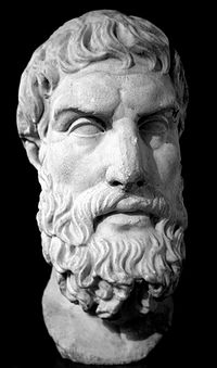 According to the Gargittius historian Epicurus, at this region the dead body of Eurυstheus was buried, an opponent of Hercules
who gained the kingship at Mycenae
after a battle at Marathon
, where he buried his opponent's head.
Meanwhile, the Pallantides
, the 50 sons of Pallas
, leader of Pallini and brother of Aegeus
, claimed the throne from Aegeus' son, Theseus
, whom they never recognized as a legal successor of the Attic kingdom. Theseus moved for a while to Crete
and the Pallantides assumed he would not return. When Theseus came back to Attica from his journey to Hades
, he was informed at Gargittos of the rule of the Pallantides and the establishment of the throne at Pallini. Cursing the Athenians, he self-exiles to Crete. However, he returned one day unexpectedly and the Pallantides decided to take over the throne permanently. Therefore, they form two teams and declared war. The first team threads alongside Pallas, waiting for Theseus at the southeastern gate of Hymettus at Sphettos, while the second one sets an ambush at the northeastern gate at Gargittos, in case Thiseas decided to fight against their father. However, their plans fail when he is informed the forerunner Leo
and by one surprising attack he manages to extinguish his enemies at Gargittos and at the same time scatter the other team. Theseus now may permanently state his predominance over the city of Athens and gain his citizens' respect once again.
and byzantine
times, Attica is decayed, although there are some findings that indicate the existence of settlements at that time. In particular, one may come across the Saint Dimitrios' church at Aitolias Street, Saint George's church at Attica Street, Agion Panton at Saint Nektarios Street, Saint John Theologos at Miaoulis Street. In addition, ruins of the Saint Nikolaos church are found on top of the Pallinidi Athena sanctuary and a marble lion (λέων). Since the 5th century AC until the Roman conquest, findings around Stavros indicate the colonization of the area. Recent excavations at a prehistoric graveyard at Fouresi Hill brought to light ruins of a palaiochristian temple that proves the existence of a Christian community.
were sent to Mesogea to protect the Duchy of Athens
which was established in 1205 by the Franks
, after the conquest of Constantinople
during the Fourth Crusade
. Arvanites reinforce the working population, while later they bring their families along and root in the Mesogea area, to which they bring their language, customs and place names.
in 1456, after a historical course of 251 years. Attica natives and arvanites lose their land and are violently separated by their children. The settlement that is set at the location of ancient Paiania is named "Liopesi", an arvanitic name, whereas many neighbourhoods preserve their Byzantine names.
shepherds to graze too. The shepherds used to bring their animals from Penteli where they lived and worked during the summertime, down to Gerakas during the cold winter nights. In his attempt to give financial independence to the monastery, Saint Timotheos bought pieces of the land around, displacing the shepherds away to a place called Labrika, near modern Koropi
. This fact led Timotheos and other land owners to conflicts, such as Saint Philothei from Athens. Some Pieces of the land were claimed were owned by the Great Logothetis Ierakas, which he gave to the monastery, whereas Philothei regained the pieces that she owned. Afterwards, some Sarakatsani and Arvanites Koropiotes returned to work at the fields, after the disputes were over.
is established, merging the Municipalities of Myrinous and Arafin. Seat of the new municipality is the village Koursallas, modern Koropi. The name of the municipality comes from the ancient deme of Kekropia that was named after its hero and first king of Athens, Kekrops. By the Decree B.D. of 14 July 1842, the municipality is renamed as Kropia, due to objections from the Greek archaiological services that state "mistakenly the municipality behind Ymittos was named Kekropia. Such name never existed according to older and recent geographers, but the ancient greeks called Kechropian the Acropolis and a part liing between Eleusina
and Aharnes."
By the Decree B.D. of 6 October 1847 (FEK 34), the seat of the municipality is transferred from Koropi to Markopoulon, another village near the coast. The land of modern Gerakas is covered by cultivated fields used by the Arvanites and native residents of Liopesi, Charvati and Kantza
who live and work at the mesogean plain. By the Decree B.D. of 27 January 1905 (FEK 18), the settlement of Charvati is named after its ancient ancestor, Pallini. The borders between Paiania and Pallini are not easily distinguished and expand vertically upon the land of ancient Pallini, up to the firs hills of Pentelikon, at the land of ancient Gargittos. This administrative line of Paiania (descendant of the village Liopesi) run up to the B Zone of Ymittos, a beautiful slope of the mountain covered by pine trees and fresh water wells and significant as well as located at the entrance of the Athens basin.
In 1966, a small settlement near the Lavriou Avenue, connecing Athens with Lavrium, among the pits, tries unsuccessfully for a secession from Paiania, in order to be recognized as Commune of Glyka Nera. Meanwhile, another settlement of Makedones and Ipirotes in 1967 near the old railway station at the land of Gerakas give an effort for the establishment of a Commune of Gerakas, with no success as well. A local committee is constituted and visits the prefecture office with a demand of the commune establishment. Their demand is turned down again.
Meanwhile, their western neighbours at Agia Paraskevi meet an unexpected urban development and a great population growth coming from Athens, up to the northern part of the mountain. Pallini on the other corner of the mountain seems to have established its historical seat of its ancestor, near Kantza and Paiania seems to be cut of from the Athens entrance. In 1969, the Commune of Glyka Nera is a reality, an area that cuts of the lands of Gerakas to the north from the village of Paiania to the south.
In 1974 another gathering of Gerakiotes takes place and after the police gives their permission, they visit a lawyer and constitute the memorandum of the new administrative entity they desire to create.
In 1980 approval is granted by the East Attica Prefecture and the new commune is born. The administrative borders of Gerakas enclose parts of the Stavros settlement around the Army's Hill, as well as the droughty fields of the southern hills of Penteli up to the marble workshops and the scattered industries. An informal local poll takes place for the name of the new commune, among the names of the three settlements of Gerakas, Stavros and Gargittos and they decide to name it Gerakas.
sources:ESYE, Municipality of Gerakas
left an enormous heritage to the city. Some of the great works completed are the Attiki Odos
, the Ymittos Circuital Road, as well as the Doukissis Plakentias and Pallini Metro
and Suburban Railway
stations. In addition, the Marathonos Avenue was widened and the Spaton Avenue was recreated. The great transportational works give the spark for mass construction of the farmlands which are cut into small fields, while the building activity gave an archtitectural uniformity to the city.
During the recent years, Gerakas is trying to balance between the variant forms of development and its urbanization, while it seems to "flirt" with the borders of the Athens metropolitan city. Some of the city's conveniencies are the easy connection between the Athens basin and the East Attica plain, the significan location between the two greak attica mountains and the modern architecture. Among the problems the municipality faces are the delay of the excretory system and some bungling of the street layout. The city recently participated at the SPAP organization as the 23rd member which aims to protect and recreate the wounded mountain of Penteli, as well as the Marathonios Anaptyksiaki which aims to the development of the northern mesogea municipalities. A significant role is also attributed to the local cultural union of "Pigi" that tries to help the city to be known and developed.
East Attica
East Attica is one of the regional units of Greece. It is part of the region of Attica. The capital of the regional unit is the town of Pallini. The regional unit covers the eastern part of the agglomeration of Athens, and also the rural area to its east....
, Greece
Greece
Greece , officially the Hellenic Republic , and historically Hellas or the Republic of Greece in English, is a country in southeastern Europe....
. Since the 2011 local government reform it is part of the municipality Pallini
Pallini
Pallini , ancient form and Latin: Pallene, is a suburb and a municipality in the northeastern part of Athens, Greece. The seat of the municipality is the town Gerakas. It is located east of Athens, midway between it and the Petalies Gulf. It is the seat of administration of the East Attica Prefecture...
, of which it is the seat and a municipal unit.
In antiquity
Ancient Greece
Ancient Greece is a civilization belonging to a period of Greek history that lasted from the Archaic period of the 8th to 6th centuries BC to the end of antiquity. Immediately following this period was the beginning of the Early Middle Ages and the Byzantine era. Included in Ancient Greece is the...
Gerakas constituted Attica
Attica
Attica is a historical region of Greece, containing Athens, the current capital of Greece. The historical region is centered on the Attic peninsula, which projects into the Aegean Sea...
's deme
Deme
In Ancient Greece, a deme or demos was a subdivision of Attica, the region of Greece surrounding Athens. Demes as simple subdivisions of land in the countryside seem to have existed in the 6th century BC and earlier, but did not acquire particular significance until the reforms of Cleisthenes in...
of Gargittos of the Aegides tribe that was located at the mesogea land, according to the administrative model of Cleisthenes
Cleisthenes
Cleisthenes was a noble Athenian of the Alcmaeonid family. He is credited with reforming the constitution of ancient Athens and setting it on a democratic footing in 508/7 BC...
.
Today, it is a rapidly developing city of the northern mesogea and the eastern gate to the Athens basin. It is known as the birthplace of the famous philosopher Epicurus
Epicurus
Epicurus was an ancient Greek philosopher and the founder of the school of philosophy called Epicureanism.Only a few fragments and letters remain of Epicurus's 300 written works...
.
The city is set at a significant place at the junction of Ymittos
Ymittos
Ymittos , is a suburb of Athens, Greece. Since the 2011 local government reform it is part of the municipality Dafni-Ymittos, of which it is a municipal unit....
and Penteli foothills. The limits of Gerakas expand from Stavros
Stavros
Stavros is a Greek name. It comes from 'σταυρóς', Greek for cross.- People with the given name Stavros :*Stavros Arnaoutakis, Greek politician and Member of the European Parliament*Stavros Damianides, Greek-Australian musician...
up to the Koufos and Desi Hills, 12 km northeast of Athens and just 2 km west of Pallini
Pallini
Pallini , ancient form and Latin: Pallene, is a suburb and a municipality in the northeastern part of Athens, Greece. The seat of the municipality is the town Gerakas. It is located east of Athens, midway between it and the Petalies Gulf. It is the seat of administration of the East Attica Prefecture...
. The city has a population of 13,990 residents (in 2001), covering a land area of 11 km2 and having a density of 1,265 residents per km2. Gerakas can be seen at an elevation of 190 to 374 metres, giving the area both flat and mountainous characteristics. Due to rapid growth during the last years, Gerakas has a calculated population of 30.000 residents and a density of 2.727 residents per km2, according to municipal estimates.
Overview
The first permanent residents inhabited around the old AthensAthens
Athens , is the capital and largest city of Greece. Athens dominates the Attica region and is one of the world's oldest cities, as its recorded history spans around 3,400 years. Classical Athens was a powerful city-state...
–Laurium
Laurium
Laurium or Lavrio is a town in southeastern part of Attica, Greece. It is the seat of the municipality of Lavreotiki...
highway that passed through, descending from Northern Greece, mostly Arvanites
Arvanites
Arvanites are a population group in Greece who traditionally speak Arvanitika, a dialect of the Albanian language. They settled in Greece during the late Middle Ages and were the dominant population element of some regions of the Peloponnese and Attica until the 19th century...
from Ipiros sent to the Masogean plain at around 1205 a. C. as mercenaries to protect the Duchy of Athens
Duchy of Athens
The Duchy of Athens was one of the Crusader States set up in Greece after the conquest of the Byzantine Empire during the Fourth Crusade, encompassing the regions of Attica and Boeotia, and surviving until its conquest by the Ottoman Empire in the 15th century....
. On the northern part of the city islanders from the Aegean Sea
Aegean Sea
The Aegean Sea[p] is an elongated embayment of the Mediterranean Sea located between the southern Balkan and Anatolian peninsulas, i.e., between the mainlands of Greece and Turkey. In the north, it is connected to the Marmara Sea and Black Sea by the Dardanelles and Bosporus...
came to work at the world famous marble workshops of Penteli. Until the late 70s, most of the land was covered by farmhouses that constitute a Paiania
Paiania
Paiania is a town and a municipality in East Attica, Greece. It is an eastern suburb of Athens, locatwed east of Mount Hymettus. Until the late 20th century, the area was known as Liopessi . Half of the municipality and the western part is the rocky landscape of Mount Hymettus...
n settlement, while in 1980 it was recognized as a new commune of East Attica. The name of the commune arises after an informal referendum among the three settlements of "Gerakas", "Stavros" and "Gargittos". The center of the city is located around the Mekedonias Square, northern of Marathonos Avenue, which is a meeting place for all residents and visitors, a true adornment, whereas St. John is the patron saint of Gerakas. The main shopping district runs along the Marathonos Avenue, where the industrial and business activity is located.
Etymology
Lydia
Lydia was an Iron Age kingdom of western Asia Minor located generally east of ancient Ionia in the modern Turkish provinces of Manisa and inland İzmir. Its population spoke an Anatolian language known as Lydian....
n Pelops
Pelops
In Greek mythology, Pelops , was king of Pisa in the Peloponnesus. He was the founder of the House of Atreus through his son of that name....
. According to the hιstorian Paysanias
Pausanias (geographer)
Pausanias was a Greek traveler and geographer of the 2nd century AD, who lived in the times of Hadrian, Antoninus Pius and Marcus Aurelius. He is famous for his Description of Greece , a lengthy work that describes ancient Greece from firsthand observations, and is a crucial link between classical...
, Gargittos was the son of Ion
Ion (mythology)
According to Greek mythology, Ion was the illegitimate child of Creüsa, daughter of Erechtheus and wife of Xuthus. Creusa conceived Ion with Apollo then she abandoned the child. Apollo asked Hermes to take Ion from his cradle. Ion was saved by a priestess of the Delphic Oracle...
.
During the middle ages
Middle Ages
The Middle Ages is a periodization of European history from the 5th century to the 15th century. The Middle Ages follows the fall of the Western Roman Empire in 476 and precedes the Early Modern Era. It is the middle period of a three-period division of Western history: Classic, Medieval and Modern...
, the region is called "Karyttos", as viewed by the foreign cartographers' work. It is a region of great religious activity, where the Saint Nikolaos Church is preserved at Patima, which Saint Timotheos used as a place for asceticism until the Penteli Monastery was finished.
The modern name of "Gerakas" comes from the religious name of the Great Logothetis Ierakas who owned large pieces of land during the 16th century a.C., some of which were under proprietary claims between Saint Timotheos and Saint Philothei. He decided to give his titles and resolve the dispute, therefore they named the region after him. His name Ierakas comes from Ieraks (Iέραξ) which means hawk (in modern Greek geraki). The name inflects as ο Ieraks (ο Ιέραξ), tou Ierakos (του Ιέρακος), ton Ieraka (τον Ιέρακα), and in modern Greek Geraka. In the nominative form it is today used as Gerakas (ο Γέρακας) and it is a singular masculine noun.
Topography
Gerakas expands vertically between the mountain junction, covering an area of 11 km2, reaching an elevation of 374 metres up to the land of Penteli. The city is located 12 kilometers northeast of Athens and 2 km west of Pallini. It is surrounded by the Municipalities of Agia Paraskevi, Halandri, Vrilissia, Penteli, the Commune of Anthoussa, as well as the Municipalities of Pallini and Glika Nera. At first, it was enclosed geographically within the Athens basin, but due to borders allocation it was partially removed towards the mesogean plain, losing pieces of Patima, Pefka and Stavros from Chalandri and Agia Paraskevi and gaining parts of Balana from Pallini. Substantially, Gerakas is a part of the northeastern part of Athens, as it receives large amounts of athenian population during the recent years.
Gerakas, Stavros, Gargittos, Patima, Balana and the mountainous settlement of Desi are some of the most known modern neighbourhoods of the city. Gerakas is surrounded by Vrilissia
Vrilissia
Vrilissia is a mildly urbanized northeastern suburb and a municipality of the North Athens regional unit, in the Attica region. It is located at the southwestern accessible foot of the Penteli Mountain, from which it was named after as the ancient name of the mountain was Vrilissos...
, Halandri and Agia Paraskevi to the west, Glyka Nera
Glyka Nera
Glyka Nera , is a suburb in the northeastern part of Athens, Greece. Since the 2011 local government reform it is part of the municipality Paiania, of which it is a municipal unit....
to the south, Pallini
Pallini
Pallini , ancient form and Latin: Pallene, is a suburb and a municipality in the northeastern part of Athens, Greece. The seat of the municipality is the town Gerakas. It is located east of Athens, midway between it and the Petalies Gulf. It is the seat of administration of the East Attica Prefecture...
and Anthousa
Anthousa
Anthousa is a suburb of Athens in the region of Attica, Greece. Since the 2011 local government reform it is part of the municipality Pallini, of which it is a municipal unit....
to the east and Penteli
Penteli
Pentéli or Pendeli, , and Vrilissos or Vrilittos , Mendeli in medieval times) is a tall mountain and mountain range situated northeast of Athens and southwest of Marathon. Its elevation is 1,109 m...
to the north.
Antiquity
In Ancient GreeceAncient Greece
Ancient Greece is a civilization belonging to a period of Greek history that lasted from the Archaic period of the 8th to 6th centuries BC to the end of antiquity. Immediately following this period was the beginning of the Early Middle Ages and the Byzantine era. Included in Ancient Greece is the...
, during the 6th century BC, throughout the shine of the Athenian State, a great union is established by the residents of Aharnes, Gargittos, Pallini and Paiania, at the heart of the land of Attica. These residents are called at that time Athenian citizens, descendents of the Ionian tribe
Ionians
The Ionians were one of the four major tribes into which the Classical Greeks considered the population of Hellenes to have been divided...
. The union takes place at a significant position, as a passage from the great city to the plain delimited by the Attica mountains, reaching the east coast. The religious and political alliance is centered around the famous Pallinida Athena sanctuary, a glorious temple where the goddess Athena was worshiped, attracting the respect, as well as the religious and trading interest of the citizens of Attica. This was a temple of similar beauty and architecture of those of Poseidon
Poseidon
Poseidon was the god of the sea, and, as "Earth-Shaker," of the earthquakes in Greek mythology. The name of the sea-god Nethuns in Etruscan was adopted in Latin for Neptune in Roman mythology: both were sea gods analogous to Poseidon...
at Sounion
Sounion
Cape Sounion is a promontory located SSE of Athens, at the southernmost tip of the Attica peninsula in Greece.Cape Sounion is noted as the site of ruins of an ancient...
, Nemesis
Nemesis (mythology)
In Greek mythology, Nemesis , also called Rhamnousia/Rhamnusia at her sanctuary at Rhamnous, north of Marathon, was the spirit of divine retribution against those who succumb to hubris . The Greeks personified vengeful fate as a remorseless goddess: the goddess of revenge...
at Ramnous and Hephaestus
Hephaestus
Hephaestus was a Greek god whose Roman equivalent was Vulcan. He is the son of Zeus and Hera, the King and Queen of the Gods - or else, according to some accounts, of Hera alone. He was the god of technology, blacksmiths, craftsmen, artisans, sculptors, metals, metallurgy, fire and volcanoes...
at the ancient agora
Agora
The Agora was an open "place of assembly" in ancient Greek city-states. Early in Greek history , free-born male land-owners who were citizens would gather in the Agora for military duty or to hear statements of the ruling king or council. Later, the Agora also served as a marketplace where...
of Athens. The temple was accessible through stone paths connecting it with the city of Athens and other great cities in Attica.
In 546 BC, the temple is meant to be marked by historical events, as Peisistratos
Peisistratos (Athens)
Peisistratos was a tyrant of Athens from 546 to 527/8 BC. His legacy lies primarily in his institution of the Panathenaic Festival and the consequent first attempt at producing a definitive version for Homeric epics. Peisistratos' championing of the lower class of Athens, the Hyperakrioi, can be...
and his followers strike against those opposed to the tyranny in Athens. According to the great historian Herodotus
Herodotus
Herodotus was an ancient Greek historian who was born in Halicarnassus, Caria and lived in the 5th century BC . He has been called the "Father of History", and was the first historian known to collect his materials systematically, test their accuracy to a certain extent and arrange them in a...
, for the third time the scheming tyrant tries to take over the governance that his opponents had taken away from him, the Alcmaeonidae
Alcmaeonidae
The Alcmaeonidae or Alcmaeonids were a powerful noble family of ancient Athens, a branch of the Neleides who claimed descent from the mythological Alcmaeon, the great-grandson of Nestor....
. And, while the armies were encamped at the junction of Vrilittos and Hymettus
Hymettus
Hymettus, also Hymettos is a mountain range in the Athens area, East Central Greece. It is also colloquially known as Trellos or Trellovouno , a name of uncertain origin...
mountains, Amphilitus, augur of the temple shows up in front of Peisistratos and gives him an oracle, assuring him that he has gained the favor of the goddess Athena. Peisistratos, confident on his victory decides to spring on his opponents, attacking at the right time, putting them to fight. After his dominance, he honors his dead soldiers by setting up monuments at the place of the battle. At the environs of Gargittos and Pallini where the battle took place, tombs with monuments are set at each grave of the soldiers, who are buried alongside with their favourite heirlooms, such as vessels, jewelry and coins. Afterwards, Peisistratos moves on to Athens where he establishes tyranny.
When Peisistratos dies, in 527 BC, Cleisthenes
Cleisthenes
Cleisthenes was a noble Athenian of the Alcmaeonid family. He is credited with reforming the constitution of ancient Athens and setting it on a democratic footing in 508/7 BC...
, a prominent political figure of this era, tries to give an end to tyranny, while conflicts between Athenians and Sparta
Sparta
Sparta or Lacedaemon, was a prominent city-state in ancient Greece, situated on the banks of the River Eurotas in Laconia, in south-eastern Peloponnese. It emerged as a political entity around the 10th century BC, when the invading Dorians subjugated the local, non-Dorian population. From c...
ns, Chalkidans and Thebans
Thebes, Greece
Thebes is a city in Greece, situated to the north of the Cithaeron range, which divides Boeotia from Attica, and on the southern edge of the Boeotian plain. It played an important role in Greek myth, as the site of the stories of Cadmus, Oedipus, Dionysus and others...
take place. In his effort to set equality and isonomy to the Athenian state, Cleisthenes abolishes the institutions of the genus and the tribes, while he sets up a new state structure based on the topographic orientation.
The four old Ionian tribes are negated and replaced by ten artificial which are named after their local heroes. The Attica dominion is distinguished to three zones, each of which encloses ten trittyes
Trittys
Trittyes were population divisions in ancient Attica, established by the reforms of Cleisthenes in 508 BC. The name means "thirtieth," and there were in fact thirty trittyes in Attica. Each tribe, or phyle of Athens was composed of three trittyes, one from the coast, one from the city, and one...
. Ten trittyes are created from the city of Athens (asty), ten from the coast (paralia) and ten from the interior of Attica (mesogea). The region of Gargittos is located at the heart of the mesogea, which is demarcated by Flya, Dekeleia, Aphidnes and Agnous. This area is named Mesogea because, according to the ancient borders of Attica, it is the most landlocked part, at the center of the land. At the same time, specific number of deme
Deme
In Ancient Greece, a deme or demos was a subdivision of Attica, the region of Greece surrounding Athens. Demes as simple subdivisions of land in the countryside seem to have existed in the 6th century BC and earlier, but did not acquire particular significance until the reforms of Cleisthenes in...
s are set at each trittys in order for the Athenian population to be uniformly allotted. Each deme's residents are named after their deme in which they reside and are not called Athenians any more. The Deme of Gargittos took part at the Athenian State, sending four deputies to represent their citizens each year.
Hercules
Hercules is the Roman name for Greek demigod Heracles, son of Zeus , and the mortal Alcmene...
who gained the kingship at Mycenae
Mycenae
Mycenae is an archaeological site in Greece, located about 90 km south-west of Athens, in the north-eastern Peloponnese. Argos is 11 km to the south; Corinth, 48 km to the north...
after a battle at Marathon
Marathon
The marathon is a long-distance running event with an official distance of 42.195 kilometres , that is usually run as a road race...
, where he buried his opponent's head.
Meanwhile, the Pallantides
Pallantides
In Greek mythology, the Pallantidai were the fifty children of Pallas, nobles of Attica. They fought against their cousin, Theseus because they would not accept him as king. Leos, a herald of Theseus, warned him of their schemes and an ambush they had prepared for him...
, the 50 sons of Pallas
Pallas (son of Pandion)
In Greek mythology Pallas was one of the four sons of Pandion II and Pylia. Upon the death of Pandion, Pallas and his brothers took control of Athens from Metion, who had seized the throne from Pandion. They divided the government in four but Aegeas became king...
, leader of Pallini and brother of Aegeus
Aegeus
In Greek mythology, Aegeus , also Aigeus, Aegeas or Aigeas , was an archaic figure in the founding myth of Athens. The "goat-man" who gave his name to the Aegean Sea was, next to Poseidon, the father of Theseus, the founder of Athenian institutions and one of the kings of Athens.-His reign:Upon the...
, claimed the throne from Aegeus' son, Theseus
Theseus
For other uses, see Theseus Theseus was the mythical founder-king of Athens, son of Aethra, and fathered by Aegeus and Poseidon, both of whom Aethra had slept with in one night. Theseus was a founder-hero, like Perseus, Cadmus, or Heracles, all of whom battled and overcame foes that were...
, whom they never recognized as a legal successor of the Attic kingdom. Theseus moved for a while to Crete
Crete
Crete is the largest and most populous of the Greek islands, the fifth largest island in the Mediterranean Sea, and one of the thirteen administrative regions of Greece. It forms a significant part of the economy and cultural heritage of Greece while retaining its own local cultural traits...
and the Pallantides assumed he would not return. When Theseus came back to Attica from his journey to Hades
Hades
Hades , Hadēs, originally , Haidēs or , Aidēs , meaning "the unseen") was the ancient Greek god of the underworld. The genitive , Haidou, was an elision to denote locality: "[the house/dominion] of Hades". Eventually, the nominative came to designate the abode of the dead.In Greek mythology, Hades...
, he was informed at Gargittos of the rule of the Pallantides and the establishment of the throne at Pallini. Cursing the Athenians, he self-exiles to Crete. However, he returned one day unexpectedly and the Pallantides decided to take over the throne permanently. Therefore, they form two teams and declared war. The first team threads alongside Pallas, waiting for Theseus at the southeastern gate of Hymettus at Sphettos, while the second one sets an ambush at the northeastern gate at Gargittos, in case Thiseas decided to fight against their father. However, their plans fail when he is informed the forerunner Leo
LEO
LEO as an initialism may refer to:* Low Earth orbit, a satellite path* Law enforcement officer, an official* Louisville Eccentric Observer, a newspaper* LEO , an electronic device* LEO , a lunar mission...
and by one surprising attack he manages to extinguish his enemies at Gargittos and at the same time scatter the other team. Theseus now may permanently state his predominance over the city of Athens and gain his citizens' respect once again.
Christian and Byzantine Times
During the christianChristian
A Christian is a person who adheres to Christianity, an Abrahamic, monotheistic religion based on the life and teachings of Jesus of Nazareth as recorded in the Canonical gospels and the letters of the New Testament...
and byzantine
Byzantine
Byzantine usually refers to the Roman Empire during the Middle Ages.Byzantine may also refer to:* A citizen of the Byzantine Empire, or native Greek during the Middle Ages...
times, Attica is decayed, although there are some findings that indicate the existence of settlements at that time. In particular, one may come across the Saint Dimitrios' church at Aitolias Street, Saint George's church at Attica Street, Agion Panton at Saint Nektarios Street, Saint John Theologos at Miaoulis Street. In addition, ruins of the Saint Nikolaos church are found on top of the Pallinidi Athena sanctuary and a marble lion (λέων). Since the 5th century AC until the Roman conquest, findings around Stavros indicate the colonization of the area. Recent excavations at a prehistoric graveyard at Fouresi Hill brought to light ruins of a palaiochristian temple that proves the existence of a Christian community.
Latin Empire
Arvanite mercenaries from Northern EpirusNorthern Epirus
Northern Epirus is a term used to refer to those parts of the historical region of Epirus, in the western Balkans, that are part of the modern Albania. The term is used mostly by Greeks and is associated with the existence of a substantial ethnic Greek population in the region...
were sent to Mesogea to protect the Duchy of Athens
Duchy of Athens
The Duchy of Athens was one of the Crusader States set up in Greece after the conquest of the Byzantine Empire during the Fourth Crusade, encompassing the regions of Attica and Boeotia, and surviving until its conquest by the Ottoman Empire in the 15th century....
which was established in 1205 by the Franks
Franks
The Franks were a confederation of Germanic tribes first attested in the third century AD as living north and east of the Lower Rhine River. From the third to fifth centuries some Franks raided Roman territory while other Franks joined the Roman troops in Gaul. Only the Salian Franks formed a...
, after the conquest of Constantinople
Constantinople
Constantinople was the capital of the Roman, Eastern Roman, Byzantine, Latin, and Ottoman Empires. Throughout most of the Middle Ages, Constantinople was Europe's largest and wealthiest city.-Names:...
during the Fourth Crusade
Fourth Crusade
The Fourth Crusade was originally intended to conquer Muslim-controlled Jerusalem by means of an invasion through Egypt. Instead, in April 1204, the Crusaders of Western Europe invaded and conquered the Christian city of Constantinople, capital of the Eastern Roman Empire...
. Arvanites reinforce the working population, while later they bring their families along and root in the Mesogea area, to which they bring their language, customs and place names.
Ottoman domination
The Duchy of Athens is preserved until the conquest of the athenians by the TurksTurkey
Turkey , known officially as the Republic of Turkey , is a Eurasian country located in Western Asia and in East Thrace in Southeastern Europe...
in 1456, after a historical course of 251 years. Attica natives and arvanites lose their land and are violently separated by their children. The settlement that is set at the location of ancient Paiania is named "Liopesi", an arvanitic name, whereas many neighbourhoods preserve their Byzantine names.
Middle Ages
Gerakas is closely connected with the history of the Penteliko, as the wider landscape was a nest of religious activity but pastoral as well. When the Great Penteli Monastery is established by Saint Timotheos in 1578, the Saint Nikolaos church at Gargittos is used for asceticism, while other churches are also set at the region. This specific area is called Karyttos, a place for the monks to rest, but a place for the SarakatsaniSarakatsani
The Sarakatsani are a group of Greek transhumant shepherds inhabiting chiefly Greece, with a smaller presence in neighbouring Bulgaria, southern Albania and the Republic of Macedonia. Historically centered around the Pindus mountains, they have been currently urbanised to a significant degree...
shepherds to graze too. The shepherds used to bring their animals from Penteli where they lived and worked during the summertime, down to Gerakas during the cold winter nights. In his attempt to give financial independence to the monastery, Saint Timotheos bought pieces of the land around, displacing the shepherds away to a place called Labrika, near modern Koropi
Koropi
Koropi , is a suburb in the eastern part of Athens, Greece. It is the seat of the municipality Kropia. The Hymettus mountain is to the west. It has a metro station via subway station...
. This fact led Timotheos and other land owners to conflicts, such as Saint Philothei from Athens. Some Pieces of the land were claimed were owned by the Great Logothetis Ierakas, which he gave to the monastery, whereas Philothei regained the pieces that she owned. Afterwards, some Sarakatsani and Arvanites Koropiotes returned to work at the fields, after the disputes were over.
Hellenic State
During the years of the Hellenic independence, in 1835 the Municipality of Myrinous of the province of Attica is established by the Decree BD of 1 October (FEK 17) and the seat is located at the settlement of Liopesi, center of the ancient trittys of Paiania. The name Myrinous comes from the coastal deme that is located at modern Markopoulo. The new municipality covers almost the whole mesogea plain and hardly presents 431 residents. During the next years, there are gradual merges of new settlements, whereas in 1840 by the Decree B.D. of 30 August the Municipality of KekropiaKekropia
Kekropia is a former municipality in Aetolia-Acarnania, West Greece, Greece. Since the 2011 local government reform it is part of the municipality Aktio-Vonitsa, of which it is a municipal unit. Population 4,494 . The seat of the municipality was in Palairos....
is established, merging the Municipalities of Myrinous and Arafin. Seat of the new municipality is the village Koursallas, modern Koropi. The name of the municipality comes from the ancient deme of Kekropia that was named after its hero and first king of Athens, Kekrops. By the Decree B.D. of 14 July 1842, the municipality is renamed as Kropia, due to objections from the Greek archaiological services that state "mistakenly the municipality behind Ymittos was named Kekropia. Such name never existed according to older and recent geographers, but the ancient greeks called Kechropian the Acropolis and a part liing between Eleusina
Eleusina
Eleusina is a town and municipality in West Attica, Greece. It is situated about 18 km northwest from the centre of Athens. It is located in the Thriasian Plain, at the northernmost end of the Saronic Gulf. It is the seat of administration of West Attica regional unit...
and Aharnes."
By the Decree B.D. of 6 October 1847 (FEK 34), the seat of the municipality is transferred from Koropi to Markopoulon, another village near the coast. The land of modern Gerakas is covered by cultivated fields used by the Arvanites and native residents of Liopesi, Charvati and Kantza
Kantza
Kantza may refer to:*Kantza, a settlement located east of Paiania in Attica in Greece*An older name of Stefani in the Preveza Prefecture in Greece...
who live and work at the mesogean plain. By the Decree B.D. of 27 January 1905 (FEK 18), the settlement of Charvati is named after its ancient ancestor, Pallini. The borders between Paiania and Pallini are not easily distinguished and expand vertically upon the land of ancient Pallini, up to the firs hills of Pentelikon, at the land of ancient Gargittos. This administrative line of Paiania (descendant of the village Liopesi) run up to the B Zone of Ymittos, a beautiful slope of the mountain covered by pine trees and fresh water wells and significant as well as located at the entrance of the Athens basin.
Modern Gerakas
On a more recent administrative model, Paiania and the neighbouring municipalities are subsumed within the prefecture of East Attica. At the same time, Pallini alongside Kantza border on "Upper Paiania" that is basically built around the Stavros church at the most northeastern part of the Ymittos mountain, near Agia Paraskevi. The houses are scattered around and lie between the farmlands of the Paianians.In 1966, a small settlement near the Lavriou Avenue, connecing Athens with Lavrium, among the pits, tries unsuccessfully for a secession from Paiania, in order to be recognized as Commune of Glyka Nera. Meanwhile, another settlement of Makedones and Ipirotes in 1967 near the old railway station at the land of Gerakas give an effort for the establishment of a Commune of Gerakas, with no success as well. A local committee is constituted and visits the prefecture office with a demand of the commune establishment. Their demand is turned down again.
Meanwhile, their western neighbours at Agia Paraskevi meet an unexpected urban development and a great population growth coming from Athens, up to the northern part of the mountain. Pallini on the other corner of the mountain seems to have established its historical seat of its ancestor, near Kantza and Paiania seems to be cut of from the Athens entrance. In 1969, the Commune of Glyka Nera is a reality, an area that cuts of the lands of Gerakas to the north from the village of Paiania to the south.
In 1974 another gathering of Gerakiotes takes place and after the police gives their permission, they visit a lawyer and constitute the memorandum of the new administrative entity they desire to create.
In 1980 approval is granted by the East Attica Prefecture and the new commune is born. The administrative borders of Gerakas enclose parts of the Stavros settlement around the Army's Hill, as well as the droughty fields of the southern hills of Penteli up to the marble workshops and the scattered industries. An informal local poll takes place for the name of the new commune, among the names of the three settlements of Gerakas, Stavros and Gargittos and they decide to name it Gerakas.
Demographics
In only ten years time, the commune's population grows and reaches 10,000 people, which advances Gerakas as a Municipality. Since 2001 and especially after the great transportation works that have been completed, Gerakas had a rapid growth in population, mostly Athenians leaving the center of the metropolitan area.| Year | Population |
|---|---|
| 1981 | 6,703 |
| 1991 | 8,512 |
| 2001 | 13,921 |
| 2007 | 20,000 |
| 2008 | 30,000 |
sources:ESYE, Municipality of Gerakas
Transportation
2004 was a significant date for the area, as the Athens Olympic Games2004 Summer Olympics
The 2004 Summer Olympic Games, officially known as the Games of the XXVIII Olympiad, was a premier international multi-sport event held in Athens, Greece from August 13 to August 29, 2004 with the motto Welcome Home. 10,625 athletes competed, some 600 more than expected, accompanied by 5,501 team...
left an enormous heritage to the city. Some of the great works completed are the Attiki Odos
Attiki Odos
Attiki Odos is a privately owned toll motorway in Greece. The Proastiakos high-speed suburban rail is set almost entirely in the median of the motorway, along its main section. The motorway's numbers are 6 for the main section, 64 for the Hymettus Beltway and 65 for the Aigaleo Beltway...
, the Ymittos Circuital Road, as well as the Doukissis Plakentias and Pallini Metro
Rapid transit
A rapid transit, underground, subway, elevated railway, metro or metropolitan railway system is an electric passenger railway in an urban area with a high capacity and frequency, and grade separation from other traffic. Rapid transit systems are typically located either in underground tunnels or on...
and Suburban Railway
Proastiakos
Proastiakós , is the name used for the suburban services of TrainOSE, servicing Greece's three largest cities: Athens, Thessaloniki and Patras; providing them with modern commuter rail links, towards their suburbs and also towards other cities and towns located around them.The service, operated by...
stations. In addition, the Marathonos Avenue was widened and the Spaton Avenue was recreated. The great transportational works give the spark for mass construction of the farmlands which are cut into small fields, while the building activity gave an archtitectural uniformity to the city.
Land prices
The land of Gerakas is separated into five zones for valuation purposes. The tax values are common to those of Pallini and Glika Nera, fluctuating in 2006 between € 1,050 to 1,300 / m2, whereas in 2007 they present an increase of 19% to 19,23% reaching € 1.250 to 1,550 / m2. However, due to great demand, the market values break the dam of € 2,000 / m2, reaching the € 2,200 to 2,800 / m2, similar to the values of the neighbouring northeastern suburbs of Athens.Government and politics
Spiros Giannakou was the first president of Gerakas, whereas Giannis Papadogeorgakis and Athanasios Zoutsos ensue up to the modern administrative era of the city.During the recent years, Gerakas is trying to balance between the variant forms of development and its urbanization, while it seems to "flirt" with the borders of the Athens metropolitan city. Some of the city's conveniencies are the easy connection between the Athens basin and the East Attica plain, the significan location between the two greak attica mountains and the modern architecture. Among the problems the municipality faces are the delay of the excretory system and some bungling of the street layout. The city recently participated at the SPAP organization as the 23rd member which aims to protect and recreate the wounded mountain of Penteli, as well as the Marathonios Anaptyksiaki which aims to the development of the northern mesogea municipalities. A significant role is also attributed to the local cultural union of "Pigi" that tries to help the city to be known and developed.