

Attiki Odos
Encyclopedia
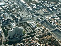
Attiki Odos is a privately owned toll motorway in Greece
. The Proastiakos
high-speed suburban rail is set almost entirely in the median of the motorway, along its main section. The motorway's numbers are 6 for the main section, 64 for the Hymettus Beltway and 65 for the Aigaleo Beltway. Together they form the outer beltways of the Greater Athens
metropolitan area.
interchange and led to the airport.
 In September 2002, the high-speed railway began construction, within the large median. In early 2003, Attiki Odos was opened from Kifissou Avenue Interchange (also known as National Road 1 / E75
Interchange) to Eleftherios Venizelos Airport; the Hymettus Ring was almost paved by this time, and tunnels were already complete.
On 3 September 2003, the Hymettus Ring opened. This part of the motorway runs in the northern part of Hymettus
and became the road to bypass Mesogeion Avenue and link to Kifissou Avenue and its suburbs, and the Airport along with the eastern suburbs of Athens.
On November 2003, the western part opened from the junction with GR-8 to Kifissou Avenue (GR-1/E75
). It has seven interchanges in total, and runs through the mountain range of Aigaleo.
On April 2004, a small 2.5 km part opened, connecting the Hymettus Ring to the westbound direction of the main route. The high-speed railway was also opened in 2004.

cameras connected to the Traffic Management Centre (TMC), which detects any incidents occurring on the motorway and informs the intervention and maintenance patrol units to provide assistance. Other sophisticated safety systems include:
Markopoulo to Eleftherios Venizelos Intl. Airport:
Hymmetus(Ymittos) Beltway:
Future expansion to the port of Rafina
is under construction, passing through the area of Pikermi
.
, Lavrio and Vouliagmeni
. The Hymettus Beltway will also be extended southwards to Vouliagmeni
. Construction is estimated to start in 2009, as the final plans were announced to be complete in late May 2008.
Greece
Greece , officially the Hellenic Republic , and historically Hellas or the Republic of Greece in English, is a country in southeastern Europe....
. The Proastiakos
Proastiakos
Proastiakós , is the name used for the suburban services of TrainOSE, servicing Greece's three largest cities: Athens, Thessaloniki and Patras; providing them with modern commuter rail links, towards their suburbs and also towards other cities and towns located around them.The service, operated by...
high-speed suburban rail is set almost entirely in the median of the motorway, along its main section. The motorway's numbers are 6 for the main section, 64 for the Hymettus Beltway and 65 for the Aigaleo Beltway. Together they form the outer beltways of the Greater Athens
Athens
Athens , is the capital and largest city of Greece. Athens dominates the Attica region and is one of the world's oldest cities, as its recorded history spans around 3,400 years. Classical Athens was a powerful city-state...
metropolitan area.
History
Construction of the project began in 1996. Part of the motorway was opened along with the Eleftherios Venizelos International Airport to which it connects, in 2001. It started from the GerakasGerakas
Gerakas is a town and a former municipality in East Attica, Greece. Since the 2011 local government reform it is part of the municipality Pallini, of which it is the seat and a municipal unit....
interchange and led to the airport.
European route E75
European route E 75 is part of the International E-road network, which is a series of main roads in Europe.The E 75 starts from Vardø, Norway in the Barents Sea and runs south through Finland, Poland, Czech Republic, Slovakia, Hungary, Serbia and Republic of Macedonia to Sitia, Greece on...
Interchange) to Eleftherios Venizelos Airport; the Hymettus Ring was almost paved by this time, and tunnels were already complete.
On 3 September 2003, the Hymettus Ring opened. This part of the motorway runs in the northern part of Hymettus
Hymettus
Hymettus, also Hymettos is a mountain range in the Athens area, East Central Greece. It is also colloquially known as Trellos or Trellovouno , a name of uncertain origin...
and became the road to bypass Mesogeion Avenue and link to Kifissou Avenue and its suburbs, and the Airport along with the eastern suburbs of Athens.
On November 2003, the western part opened from the junction with GR-8 to Kifissou Avenue (GR-1/E75
European route E75
European route E 75 is part of the International E-road network, which is a series of main roads in Europe.The E 75 starts from Vardø, Norway in the Barents Sea and runs south through Finland, Poland, Czech Republic, Slovakia, Hungary, Serbia and Republic of Macedonia to Sitia, Greece on...
). It has seven interchanges in total, and runs through the mountain range of Aigaleo.
On April 2004, a small 2.5 km part opened, connecting the Hymettus Ring to the westbound direction of the main route. The high-speed railway was also opened in 2004.
Safety
Attiki Odos is considered one of the safest motorways in Europe. It was designed under strict safety-related technical specifications, including updated hard shoulders in either direction and high quality skid-resistant asphalt pavement, dense lighting and fencing. Attiki Odos features hundreds of CCTVClosed-circuit television
Closed-circuit television is the use of video cameras to transmit a signal to a specific place, on a limited set of monitors....
cameras connected to the Traffic Management Centre (TMC), which detects any incidents occurring on the motorway and informs the intervention and maintenance patrol units to provide assistance. Other sophisticated safety systems include:
- Road pavement sensors
- Carbon monoxide measurement systems installed in tunnels
- TETRATerrestrial Trunked RadioTerrestrial Trunked Radio is a professional mobile radio and two-way transceiver specification...
system for communication with the patrol units - Elecronic variable message signs
- Automatic tunnel ventilation systems
Tolls
Toll stations are located at the interchanges leading to the Attiki Odos motorway and the toll fare is paid when entering the motorway. The fare is the same regardless of the length of journey but depends on vehicle category. Drivers can pay either by cash, e-pass or a special account card; for motorbikes and cars the standard toll fares are 1.30€ and 2.70€ respectively.Road Sections
- Main Section:
- north of Eleusis
- between MandraMandraMandra , is a town and municipality in the central part of West Attica, Greece. Since the 2011 local government reform it is part of the municipality Mandra-Eidyllia, of which it is the seat and a municipal unit.Mandra is part of the Athens metropolitan area...
and Magoula - north of AspropyrgosAspropyrgosAspropyrgos is a suburb of Athens, and a municipality in the West Attica regional unit, Attica, Greece. It is located 20 km NW of the city center of Athens in the Thriasian plain...
- between KamateroKamateroKamatero , is a suburb northwest of Athens, Greece. Since the 2011 local government reform it is part of the municipality Agioi Anargyroi-Kamatero, of which it is a municipal unit...
and AcharnaeAcharnesAcharnes is a suburb of Athens, Greece. It is the most populous municipality in East Attica. Much of the area north of the area are the forested Parnitha ranges and the parkland. The municipality is north of the Greater Ring of Athens. It is located about 10 km due north of Athens.In... - north of Neo Irakleio
- Kifissias AvenueKifissias AvenueKifissias Avenue is one of the longest avenues in the Greater Athens area. Its total length is about 20 km, beginning 4 km northeast of downtown Athens and ending by the municipal boundary of Nea Erythraia north of Kifissia...
- near VrilissiaVrilissiaVrilissia is a mildly urbanized northeastern suburb and a municipality of the North Athens regional unit, in the Attica region. It is located at the southwestern accessible foot of the Penteli Mountain, from which it was named after as the ancient name of the mountain was Vrilissos...
- GerakasGerakasGerakas is a town and a former municipality in East Attica, Greece. Since the 2011 local government reform it is part of the municipality Pallini, of which it is the seat and a municipal unit....
- east of Glyka NeraGlyka NeraGlyka Nera , is a suburb in the northeastern part of Athens, Greece. Since the 2011 local government reform it is part of the municipality Paiania, of which it is a municipal unit....
, Paeania and Markopoulo Mesogeias - west of KoropiKoropiKoropi , is a suburb in the eastern part of Athens, Greece. It is the seat of the municipality Kropia. The Hymettus mountain is to the west. It has a metro station via subway station...
- north of KerateaKerateaKeratea is a town in East Attica, Greece. Since the 2011 local government reform it is part of the municipality Lavreotiki, of which it is a municipal unit.Keratea is linked with a highway to Glyka Nera and Sounio...
- Hymettus Beltway:
- Katechaki Avenue
- east of PapagouPapagouPapagou is a suburb in the northeastern part of Athens, Greece. The city is named after Marshal Alexandros Papagos, a Greek Army General who served in the Second World War...
and Agia ParaskeviAgia ParaskeviAgia Paraskevi , is a suburb of Athens, Greece, in the northeast of Athens, about nine kilometers away from the city centre. It is linked to Athens by Mesogeion Avenue, a major road in the greater Athens area. It is a municipality within Attica region.... - Glyka Nera
Interchanges
The main part (official numbering):- (Not numbered) - GR-8A
- 1 - MandraMandraMandra , is a town and municipality in the central part of West Attica, Greece. Since the 2011 local government reform it is part of the municipality Mandra-Eidyllia, of which it is the seat and a municipal unit.Mandra is part of the Athens metropolitan area...
- 2 - MagoulaMagoula, AtticaMagoula is a town and former community of West Attica, Greece. Since the 2011 local government reform it is part of the municipality Elefsina, of which it is a municipal unit....
- 3 - (space reserved for future intersection)
- 4 - AspropyrgosAspropyrgosAspropyrgos is a suburb of Athens, and a municipality in the West Attica regional unit, Attica, Greece. It is located 20 km NW of the city center of Athens in the Thriasian plain...
- 5 - Aigaleo Beltway
- 5a - Aigaleo Beltway South
- 6 - Filis Avenue
- 7 - Dimokratias Avenue S of AcharnaeAcharnaeAcharnae was the largest deme of ancient Attica; it was located in the northwest part of the Attic plain, south of Mt. Parnes in the general vicinity of the modern suburbs of Acharnes and Ano Liosia, about due north of Athens. The Acharnians chiefly grew cereals, grapes, and olives, although...
(also known as Menidi) - 8 - Kifissou Avenue/GR-1Greek National Road 1The Greek Motorway 1 is a motorway, partly under construction, and the 2nd longest in Greece. It is the principal north-south road connection in Greece, connecting the country's capital Athens with the regions of Thessaly and Macedonia, as well as the country's second largest city,...
/E75European route E75European route E 75 is part of the International E-road network, which is a series of main roads in Europe.The E 75 starts from Vardø, Norway in the Barents Sea and runs south through Finland, Poland, Czech Republic, Slovakia, Hungary, Serbia and Republic of Macedonia to Sitia, Greece on...
(PiraeusPiraeusPiraeus is a city in the region of Attica, Greece. Piraeus is located within the Athens Urban Area, 12 km southwest from its city center , and lies along the east coast of the Saronic Gulf....
-LamiaLamia (city)Lamia is a city in central Greece. The city has a continuous history since antiquity, and is today the capital of the regional unit of Phthiotis and of the Central Greece region .-Name:...
) - 9 - Herakliou Avenue
- 10A/B - Kimis Avenue
- 11 - Kifissias Avenue
- 12 - Pendelis Avenue
- 13 - Doukissis Plakentias Avenue and Hymmetus(Ymittos) Beltway
- 14 - AnthousaAnthousaAnthousa is a suburb of Athens in the region of Attica, Greece. Since the 2011 local government reform it is part of the municipality Pallini, of which it is a municipal unit....
- 15 - Marathonos Avenue (which is the continuation of Messoghion Avenue)
- 16/Y7 - Leontario (intersects with Hymettus(Ymittos) Beltway)
- 17 - KantzaKantzaKantza may refer to:*Kantza, a settlement located east of Paiania in Attica in Greece*An older name of Stefani in the Preveza Prefecture in Greece...
- 18 - Peania
- 19 - (space reserved for future intersection)
- 20 - Markopoulo MesogaiasMarkopoulo MesogaiasMarkopoulo, municipally Markopoulo Mesogaias to avoid confusion with Markopoulo Oropou in Oropos is a suburban town in southeastern Attica in the Mesogaian plain north of the mountains, approximately 30 km SE of Athens, S of Rafina, S of the Eleftherios Venizelos International Airport, SW of...
/Eleftherios Venizelos International Airport
Markopoulo to Eleftherios Venizelos Intl. Airport:
- K1 (20A) - Attiki Odos
- K2 (20B) - local road (North Koropi)
Hymmetus(Ymittos) Beltway:
- Y1 - Katehaki Avenue
- Y2 - PapagouPapagouPapagou is a suburb in the northeastern part of Athens, Greece. The city is named after Marshal Alexandros Papagos, a Greek Army General who served in the Second World War...
- Y3 - Dimokritos
- Y4 - Agia ParaskeviAgia ParaskeviAgia Paraskevi , is a suburb of Athens, Greece, in the northeast of Athens, about nine kilometers away from the city centre. It is linked to Athens by Mesogeion Avenue, a major road in the greater Athens area. It is a municipality within Attica region....
- Y5 - (space reserved for future intersection)
- Y6 - Glyka NeraGlyka NeraGlyka Nera , is a suburb in the northeastern part of Athens, Greece. Since the 2011 local government reform it is part of the municipality Paiania, of which it is a municipal unit....
- Y7/16 - Leontario (see above)
- Y8 - PalliniPalliniPallini , ancient form and Latin: Pallene, is a suburb and a municipality in the northeastern part of Athens, Greece. The seat of the municipality is the town Gerakas. It is located east of Athens, midway between it and the Petalies Gulf. It is the seat of administration of the East Attica Prefecture...
Future expansion to the port of Rafina
Rafina
Rafina is a town located on the eastern coast of Attica in Greece. It has a population of 10,701 inhabitants . Since the 2011 local government reform it is part of the municipality Rafina-Pikermi, of which it is the seat and a municipal unit.-Geography:Rafina lies east of the Penteli mountains and...
is under construction, passing through the area of Pikermi
Pikermi
Pikermi is a town and a former community of Attica, Greece. Since the 2011 local government reform it is part of the municipality Rafina-Pikermi, of which it is a municipal unit....
.
Sections
The brackets are non-state highway numbers.- Attiki Odos (6) - 47 km
- SE of Markopoulo to Eleftherios Venizelos - 4 km
- HymettusHymettusHymettus, also Hymettos is a mountain range in the Athens area, East Central Greece. It is also colloquially known as Trellos or Trellovouno , a name of uncertain origin...
/Ymittos Beltway - 12 km - Aigaleo Beltway (65) - 8 km, partly under construction as of 2006.
Expansion
On October 21, 2005 a new expansion plan was proposed. 76 km of motorway will be constructed, bringing the total length to 141 km. Extensions will be constructed towards RafinaRafina
Rafina is a town located on the eastern coast of Attica in Greece. It has a population of 10,701 inhabitants . Since the 2011 local government reform it is part of the municipality Rafina-Pikermi, of which it is the seat and a municipal unit.-Geography:Rafina lies east of the Penteli mountains and...
, Lavrio and Vouliagmeni
Vouliagmeni
Vouliagmeni is a seaside town and former municipality 20 km south of Athens, Greece. Since the 2011 local government reform it is part of the municipality Vari-Voula-Vouliagmeni, of which it is a municipal unit. Its population was 6,442 at the 2001 census. Vouliagmeni is among the most...
. The Hymettus Beltway will also be extended southwards to Vouliagmeni
Vouliagmeni
Vouliagmeni is a seaside town and former municipality 20 km south of Athens, Greece. Since the 2011 local government reform it is part of the municipality Vari-Voula-Vouliagmeni, of which it is a municipal unit. Its population was 6,442 at the 2001 census. Vouliagmeni is among the most...
. Construction is estimated to start in 2009, as the final plans were announced to be complete in late May 2008.