

Geography of Missouri
Encyclopedia
Missouri
Missouri is a US state located in the Midwestern United States, bordered by Iowa, Illinois, Kentucky, Tennessee, Arkansas, Oklahoma, Kansas and Nebraska. With a 2010 population of 5,988,927, Missouri is the 18th most populous state in the nation and the fifth most populous in the Midwest. It...
, a state near the geographical center of the United States
United States
The United States of America is a federal constitutional republic comprising fifty states and a federal district...
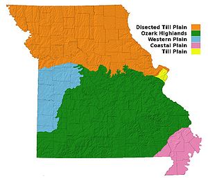
, has three distinct physiographic divisions:
- a north-western upland plain or prairie region part of the Interior Plains' Central Lowland (areas Osage Plain 12f and Dissected Till Plains 12e) known as the northern plains
- a lowland in the extreme southeast bootheelBootheelThe Missouri Bootheel is the southeasternmost part of the state of Missouri, extending south of 36°30’ north latitude, so called because its shape in relation to the rest of the state resembles the heel of a boot. Strictly speaking, it is composed of the counties of Dunklin, New Madrid, and Pemiscot...
region of Missouri, part of the Atlantic Plain known as the Mississippi Alluvial Plain (areas 3e) or the Mississippi embaymentMississippi embaymentThe Mississippi Embayment is a physiographic feature in the south-central United States, part of the Mississippi Alluvial Plain. It is essentially a northward continuation of the fluvial sediments of the Mississippi River Delta to its confluence with the Ohio River at Cairo, Illinois. The embayment... - the Missouri portion of the Ozark Plateau (areas 14a and 14b) which lies between the Mississippi Alluvial Plain and the Central Lowland.
The boundary between the northern plains and the Ozark region follows the
Missouri river
Missouri River
The Missouri River flows through the central United States, and is a tributary of the Mississippi River. It is the longest river in North America and drains the third largest area, though only the thirteenth largest by discharge. The Missouri's watershed encompasses most of the American Great...
from its mouth at St. Louis
St. Louis, Missouri
St. Louis is an independent city on the eastern border of Missouri, United States. With a population of 319,294, it was the 58th-largest U.S. city at the 2010 U.S. Census. The Greater St...
to Columbia
Columbia, Missouri
Columbia is the fifth-largest city in Missouri, and the largest city in Mid-Missouri. With a population of 108,500 as of the 2010 Census, it is the principal municipality of the Columbia Metropolitan Area, a region of 164,283 residents. The city serves as the county seat of Boone County and as the...
. This also corresponds to the southernmost extent of glaciation during the Pre-Illinoian Stage which destroyed the remnant plateau to the north but left the ancient landforms to the south unaltered. The Ozark boundary runs southwestward from there towards Joplin
Joplin, Missouri
Joplin is a city in southern Jasper County and northern Newton County in the southwestern corner of the US state of Missouri. Joplin is the largest city in Jasper County, though it is not the county seat. As of the 2010 census, the city population was 50,150...
at the southeast corner of Kansas
Kansas
Kansas is a US state located in the Midwestern United States. It is named after the Kansas River which flows through it, which in turn was named after the Kansa Native American tribe, which inhabited the area. The tribe's name is often said to mean "people of the wind" or "people of the south...
. The boundary between the Ozark and lowland regions runs southwest from Cape Girardeau
Cape Girardeau, Missouri
Cape Girardeau is a city located in Cape Girardeau and Scott counties in Southeast Missouri in the United States. It is located approximately southeast of St. Louis and north of Memphis. As of the 2010 census, the city's population was 37,941. A college town, it is the home of Southeast Missouri...
on the Mississippi River
Mississippi River
The Mississippi River is the largest river system in North America. Flowing entirely in the United States, this river rises in western Minnesota and meanders slowly southwards for to the Mississippi River Delta at the Gulf of Mexico. With its many tributaries, the Mississippi's watershed drains...
to the Arkansas
Arkansas
Arkansas is a state located in the southern region of the United States. Its name is an Algonquian name of the Quapaw Indians. Arkansas shares borders with six states , and its eastern border is largely defined by the Mississippi River...
border just southwest of Poplar Bluff
Poplar Bluff, Missouri
Poplar Bluff is a city in Butler County located in Southeast Missouri in the United States. It is the county seat of Butler County and is known as "The Gateway to the Ozarks" among other names. As of the 2000 U.S...
.
Northern Plains
The Dissected TillTill
thumb|right|Closeup of glacial till. Note that the larger grains in the till are completely surrounded by the matrix of finer material , and this characteristic, known as matrix support, is diagnostic of till....
Plains portion of the northern plains region lies in the portion of the state north of the Missouri River
Missouri River
The Missouri River flows through the central United States, and is a tributary of the Mississippi River. It is the longest river in North America and drains the third largest area, though only the thirteenth largest by discharge. The Missouri's watershed encompasses most of the American Great...
, while the Osage plains portion extends into the southwestern portion of the state bordering the Ozark Plateau. Thus the northern plains covers an area slightly more than a third of the state. This region is a beautiful, rolling country, with a great abundance of streams.
It is more hilly and broken in its western half than in its eastern half. The elevation in the extreme northwestern Missouri is about 1200 ft (365.8 m). and in the extreme northeastern portion about 500 ft (152.4 m)., while the rim of the region to the southeast, along the border of the Ozark region, has an elevation of about 900 ft (274.3 m). The valleys for the larger streams are about 250 to 300 ft (91.4 m). deep and sometimes 8 to 20 miles (32.2 km) wide with the country bordering them being the most broken of the region.
The smaller streams have so eroded the whole face of the country that little of the original surface plain is to be seen. The Mississippi River
Mississippi River
The Mississippi River is the largest river system in North America. Flowing entirely in the United States, this river rises in western Minnesota and meanders slowly southwards for to the Mississippi River Delta at the Gulf of Mexico. With its many tributaries, the Mississippi's watershed drains...
runs along the length of Missouri's eastern side and is skirted throughout by topographic relief of 400 to 600 ft (182.9 m). elevation.
Ozark Plateau
The Ozark region is essentially a low dome, with local faulting and minor undulations, dominated by a ridge or, more exactly, a relatively even belt of highland that runs from near the Mississippi river about Ste. Genevieve to McDonald CountyMcDonald County, Missouri
McDonald County is a county located in Southwest Missouri in the United States of America. As of the 2010 U.S. Census, the population was 23,083. Its county seat is Pineville...
on the Arkansas border. High rocky bluffs rise precipitously on the Mississippi, sometimes to a height of 150 ft (45.7 m). or so above the water, from the mouth of the Meramec River to Ste. Genevieve. These mark where that river cuts the Ozark ridge. Across the Mississippi River, this ridge is continued by the Shawnee Hills in Illinois.
The elevations of the crests in Missouri vary from 1,100 to 1700 ft (518.2 m). This second physiographic region comprises somewhat less than two-thirds of the area of the state. The Burlington escarpment of Mississippian rocks, which in places is as much as 250 to 300 ft (91.4 m). in height, runs along the western edge of the Ordovician
Ordovician
The Ordovician is a geologic period and system, the second of six of the Paleozoic Era, and covers the time between 488.3±1.7 to 443.7±1.5 million years ago . It follows the Cambrian Period and is followed by the Silurian Period...
formations and divides the region into an eastern and a western area, known respectively to physiographers as the Salem Plateau and the Springfield Plateau. Headward erosion
Headward erosion
Headward erosion is a fluvial process of erosion that lengthens a stream, a valley or a gully at its head and also enlarges its drainage basin. The stream erodes away at the rock and soil at its headwaters in the opposite direction that it flows. Once a stream has begun to cut back, the erosion is...
by the south flowing tributaries to the White River
White River (Arkansas)
The White River is a 722-mile long river that flows through the U.S. states of Arkansas and Missouri.-Course:The source of the White River is in the Boston Mountains of northwest Arkansas, in the Ozark-St. Francis National Forest southeast of Fayetteville...
in northern Arkansas has created a southern escarpment to both the Springfield and Salem plateaus that runs from McDonald
McDonald County, Missouri
McDonald County is a county located in Southwest Missouri in the United States of America. As of the 2010 U.S. Census, the population was 23,083. Its county seat is Pineville...
through Barry, Stone, Christian, Douglas, and Howell counties. To the south of this escarpment lies some of the more rugged and highly dissected parts of the Missouri Ozarks. The famed Shepherd of the Hills region near Branson
Branson, Missouri
Branson is a city in Taney County in the U.S. state of Missouri. It was named after Reuben Branson, postmaster and operator of a general store in the area in the 1880s....
lies within this rugged area. To the east of the West Plains
West Plains, Missouri
West Plains is a city in Howell County, Missouri, United States. The population was 10,866 at the 2000 census. It is the county seat of Howell County. The West Plains Micropolitan Statistical Area consists of Howell County.-Geography:...
plain lies the dissected valleys of the Eleven Point River
Eleven Point River
The Eleven Point River is a river in southern Missouri and northern Arkansas, United States. It originates near Willow Springs, Missouri. It more than doubles in flow when Greer Spring Branch runs into it, adding over of water per day to the river. The name derives from the Mississippi Valley...
and the Current River
Current River (Missouri)
The Current River forms in the southeastern portion of the Ozarks of Missouri and becomes a 7th order stream as it flows southeasterly out of the Ozarks into northeastern Arkansas where it becomes a tributary of the Black River, which is a tributary of the White River, a tributary of the...
.
Superficially, each is a simple rolling plateau, much broken by erosion (though considerable undissected areas drained by underground channels remain), especially in the east, and dotted with hills. Some of these are residual outliers of the eroded Mississippian limestone
Limestone
Limestone is a sedimentary rock composed largely of the minerals calcite and aragonite, which are different crystal forms of calcium carbonate . Many limestones are composed from skeletal fragments of marine organisms such as coral or foraminifera....
s to the west, and others are the summits of a Precambrian
Precambrian
The Precambrian is the name which describes the large span of time in Earth's history before the current Phanerozoic Eon, and is a Supereon divided into several eons of the geologic time scale...
topography above and around which sedimentary formations were deposited and then eroded. There is no arrangement in chains, but only scattered rounded peaks and short ridges, with winding valleys about them.
The two highest points in the state are Taum Sauk Mountain
Taum Sauk Mountain
Taum Sauk Mountain in the Saint Francois Mountains is the highest natural point in the U.S. state of Missouri, 1,772 feet above mean sea level.The topography of Taum Sauk is that of a somewhat flat ridge rather than a peak....
at 1772 ft (540.1 m), in the St. Francois Mountains
Saint Francois Mountains
The St. Francois Mountains in southeast Missouri are a range of Precambrian igneous mountains rising over the Ozark Plateau. This range is one of the oldest exposures of igneous rock in North America....
in Iron county
Iron County, Missouri
Iron County is a county located in the Lead Belt region in Southeast Missouri in the United States. As of the 2000 U.S. Census, the county's population was 10,697. A 2008 estimate, however, showed the population to be 9,918. The largest city and county seat is Ironton...
and Lead Hill just east of the community of Cedar Gap at 1744 ft (531.6 m)., in the southwestern corner of Wright county
Wright County, Missouri
Wright County is a county located in South Central Missouri in the United States. As of the 2010 U.S. Census, the county's population was 18,815. Its county seat is Hartville. The county was officially organized on January 29, 1841, and is named after Silas Wright , a former Congressman, U.S...
.
Few localities have an elevation exceeding 1400 ft (426.7 m). Rather broad, smooth valleys, well degraded hills with rounded summits, and despite the escarpments generally smooth contours and sky-lines, characterize the bulk of the Ozark region.
Mississippi Alluvial Plain
The third region, the lowlands of the south-east and part of the Mississippi Alluvial Plain, has an area of some 3000 square miles (7,770 km²). It is an undulating country, for the most part well drained, but swampy in its lowest portions. The Mississippi is skirted with lagoons, lakes and morasses from Ste. Genevieve to the ArkansasArkansas
Arkansas is a state located in the southern region of the United States. Its name is an Algonquian name of the Quapaw Indians. Arkansas shares borders with six states , and its eastern border is largely defined by the Mississippi River...
border, and in places is confined by levees. These lowlands are the northernmost extent of the Mississippi embayment
Mississippi embayment
The Mississippi Embayment is a physiographic feature in the south-central United States, part of the Mississippi Alluvial Plain. It is essentially a northward continuation of the fluvial sediments of the Mississippi River Delta to its confluence with the Ohio River at Cairo, Illinois. The embayment...
. The area is within the New Madrid Seismic Zone
New Madrid Seismic Zone
The New Madrid Seismic Zone , sometimes called the New Madrid Fault Line, is a major seismic zone and a prolific source of intraplate earthquakes in the southern and midwestern United States, stretching to the southwest from New Madrid, Missouri.The New Madrid fault system was responsible for the...
and includes the epicenter
Epicenter
The epicenter or epicentre is the point on the Earth's surface that is directly above the hypocenter or focus, the point where an earthquake or underground explosion originates...
location of the 1811-1812 New Madrid Earthquake
New Madrid earthquake
The 1811-1812 New Madrid earthquakes were an intense intraplate earthquake series beginning with an initial pair of very large earthquakes on December 16, 1811. These earthquakes remain the most powerful earthquakes ever to hit the eastern United States in recorded history...
at New Madrid, Missouri
New Madrid, Missouri
New Madrid is a city in New Madrid County, Missouri, 42 miles south by west of Cairo, Illinois, on the Mississippi River. New Madrid was founded in 1788 by American frontiersmen. In 1900, 1,489 people lived in New Madrid, Missouri; in 1910, the population was 1,882. The population was 3,334 at...
.
Drainage
The drainage of the state is wholly into the Mississippi RiverMississippi River
The Mississippi River is the largest river system in North America. Flowing entirely in the United States, this river rises in western Minnesota and meanders slowly southwards for to the Mississippi River Delta at the Gulf of Mexico. With its many tributaries, the Mississippi's watershed drains...
, directly or indirectly, and to a large extent into either that river or the Missouri River
Missouri River
The Missouri River flows through the central United States, and is a tributary of the Mississippi River. It is the longest river in North America and drains the third largest area, though only the thirteenth largest by discharge. The Missouri's watershed encompasses most of the American Great...
within the borders of the state. The latter stream, crossing the state and cutting the eastern and western borders at or near St Louis and Kansas City respectively, has a length within Missouri of 430 miles (692 km).
The areas drained into the Mississippi outside the state through
the St. Francis
St. Francis River
The Saint Francis River is a tributary of the Mississippi River, about long, in southeastern Missouri and northeastern Arkansas in the United States...
, White
White River (Arkansas)
The White River is a 722-mile long river that flows through the U.S. states of Arkansas and Missouri.-Course:The source of the White River is in the Boston Mountains of northwest Arkansas, in the Ozark-St. Francis National Forest southeast of Fayetteville...
and other minor streams are relatively small. The larger streams of the Ozark
The Ozarks
The Ozarks are a physiographic and geologic highland region of the central United States. It covers much of the southern half of Missouri and an extensive portion of northwestern and north central Arkansas...
dome are of decided interest to the physiographer. Those of the
White system have opentrough valleys bordered by hills in their
upper courses and canyons in their lower courses.
Both the Ozark region and the northern plain region are divided by minor
escarpments into ten or twelve sub-regions. There are remarkable differences in the drainage areas of their two sides, with interesting illustrations of shifting water-partings; and the White, Gasconade, Osage and other rivers are remarkable for upland meanders, lying, not on flood-plains, but around the spurs of a highland country. These incised meander
Entrenched river
An entrenched river is a river that is confined to a canyon or gorge, usually with a relatively narrow width and little or no flood plain, and often with meanders worn into the landscape...
s have been interpreted to have formed by downward erosion after uplift of an older peneplain
Peneplain
A peneplain is a low-relief plain representing the final stage of fluvial erosion during times of extended tectonic stability. The existence of peneplains, and peneplanation as a geomorphological process, is not without controversy, due to a lack of contemporary examples and uncertainty in...
surface.
Many streams in Missouri are called "rivers" though they are small enough perhaps to be called "creeks". This is due to a direct translation of the French word "rivière" which implies a stream size smaller than the French word "fleuve", meaning "a river that flows to the sea". An example of this is "Loutre River", from "Rivière Loutre", or "Otter Stream".
Caves
The Ozarks region is noted for having a well-developed karstKARST
Kilometer-square Area Radio Synthesis Telescope is a Chinese telescope project to which FAST is a forerunner. KARST is a set of large spherical reflectors on karst landforms, which are bowlshaped limestone sinkholes named after the Kras region in Slovenia and Northern Italy. It will consist of...
topography with numerous areas of sinkhole
Sinkhole
A sinkhole, also known as a sink, shake hole, swallow hole, swallet, doline or cenote, is a natural depression or hole in the Earth's surface caused by karst processes — the chemical dissolution of carbonate rocks or suffosion processes for example in sandstone...
s, stream capture
Losing stream
A losing stream, or influent stream, is a stream or river that loses water as it flows downstream. The water infiltrates into the ground recharging the local groundwater, because the water table is below the bottom of the stream channel...
, and cavern
Cave
A cave or cavern is a natural underground space large enough for a human to enter. The term applies to natural cavities some part of which is in total darkness. The word cave also includes smaller spaces like rock shelters, sea caves, and grottos.Speleology is the science of exploration and study...
development.
Caves, within areas of limestone
Limestone
Limestone is a sedimentary rock composed largely of the minerals calcite and aragonite, which are different crystal forms of calcium carbonate . Many limestones are composed from skeletal fragments of marine organisms such as coral or foraminifera....
and dolostone
Dolostone
Dolostone or dolomite rock is a sedimentary carbonate rock that contains a high percentage of the mineral dolomite. In old U.S.G.S. publications it was referred to as magnesian limestone. Most dolostone formed as a magnesium replacement of limestone or lime mud prior to lithification. It is...
bedrock, occur in great numbers in and near the Ozark Mountain region in the southwestern part of Missouri. More than a hundred have been discovered in Stone county
Stone County, Missouri
Stone County is a county located in Southwest Missouri in the United States. As of the 2010 U.S. Census, the county's population was 32,202. Its county seat is Galena...
alone, and there are many in Christian
Christian County, Missouri
Christian County is a county located in Southwest Missouri. The county had a population of 54,285 in 2000 census. According to the 2010 census, the county's population is 77,422 , making it the fastest growing county in Missouri and one of the fastest growing in the nation as the county becomes...
, Greene
Greene County, Missouri
Greene County is a county located in Southwest Missouri. As of 2010, the population was 275,174 making it the fourth most populated county in Missouri. Its county seat is Springfield...
and McDonald
McDonald County, Missouri
McDonald County is a county located in Southwest Missouri in the United States of America. As of the 2010 U.S. Census, the population was 23,083. Its county seat is Pineville...
counties.
One of the most remarkable is Marvel Cave
Marvel Cave
Marvel Cave is a National Natural Landmark located just west of Branson, Missouri, on top of Roark Mountain in Stone County. The cave was known by the Osage Indians in the early 16th century, after a tribe member fell through the cave's main entrance, a sinkhole. There is evidence that in 1541...
, a short distance
southeast of the center of Stone county. The entrance originally was through a large sink-hole at the top of Roark Mountain, though now an easier entrance has been made. Marvel Cave has an extraordinary hall-like room is about 350 ft (106.7 m). long and about 125 ft (38.1 m). wide with bluish-grey limestone walls, and an almost perfectly vaulted roof, rising from 100 to 295 ft (89.9 m). Its acoustic properties are said to be almost perfect, and it has been named the Auditorium. At one end is a remarkable stalagmitic formation of white and gold onyx, about 65 ft (19.8 m). in height and about 200 ft (61 m). in girth, called the White Throne.
Exploration of Jacob's Cavern, near Pineville
Pineville, Missouri
Pineville is a city in and the county seat of McDonald County, Missouri, United States. The population was 916 at the 2009 census, at which time it was a town. It is part of the Fayetteville–Springdale–Rogers, AR-MO Metropolitan Statistical Area....
, McDonald
McDonald County, Missouri
McDonald County is a county located in Southwest Missouri in the United States of America. As of the 2010 U.S. Census, the population was 23,083. Its county seat is Pineville...
county, revealed skeletons of men and animals along with crude implements. Crystal Cave, near Joplin, Jasper
Jasper County, Missouri
Jasper County is a county located in the US state of Missouri. It is included in the Joplin, Missouri Metropolitan Statistical Area. The 2010 total population of Jasper County was 117,404. It is the ninth most populous county in Missouri. Its county seat is Carthage, making it one of the few...
county, has its entire surface lined with calcite
Calcite
Calcite is a carbonate mineral and the most stable polymorph of calcium carbonate . The other polymorphs are the minerals aragonite and vaterite. Aragonite will change to calcite at 380-470°C, and vaterite is even less stable.-Properties:...
crystals and scalenohedron formations, from 1 to 2 ft (0.6096 m). in length. Knox Cave, in Greene
Greene County, Missouri
Greene County is a county located in Southwest Missouri. As of 2010, the population was 275,174 making it the fourth most populated county in Missouri. Its county seat is Springfield...
county, and several caverns near Ozark, in Christian
Christian County, Missouri
Christian County is a county located in Southwest Missouri. The county had a population of 54,285 in 2000 census. According to the 2010 census, the county's population is 77,422 , making it the fastest growing county in Missouri and one of the fastest growing in the nation as the county becomes...
county, are also of interest. Other caves include Fried's Cave,
about six miles (10 km) northeast of Rolla
Rolla, Missouri
Rolla is a city in Phelps County, Missouri, United States, midway between the larger cities of St. Louis and Springfield along I-44. The population in the 2010 United States Census was 19,559.It is the county seat of Phelps County...
, Phelps
Phelps County, Missouri
Phelps County is a county located in south-central Missouri in the United States.According to the U.S. Census Bureau, it includes the mean center of U.S. population in 2000. As of the 2000 U.S. Census, the county's population was 39,825. A 2008 estimate, however, showed the population to be 42,205....
county, Mark Twain Cave (in Marion county, about one mile (1.6 km) south of Hannibal
Hannibal, Missouri
Hannibal is a city in Marion and Ralls counties in the U.S. state of Missouri. Hannibal is located at the intersection of Interstate 72 and U.S. Routes 24, 36 and 61, approximately northwest of St. Louis. According to the 2010 U.S. Census the population was 17,606...
), which has a deep pool containing many eyeless fish; and various caverns in Miller, Ozark
Ozark County, Missouri
Ozark County is a county located in South Central Missouri in the United States. As of the 2000 U.S. Census, the county's population was 9,542. A 2008 estimate, however, showed the population to be 9,227. The largest city and county seat is Gainesville. From 1843 to 1845 the county was called...
,
Greene and Barry
Barry County, Missouri
Barry County is a county located in the U.S. state of Missouri. As of 2010, the population was 35,597. Its county seat is Cassville. The county was organized in 1835 and named after William Taylor Barry from Kentucky, a United States Postmaster General....
counties.