
Taum Sauk Mountain
Encyclopedia
Taum Sauk Mountain (ˈtɔːm ˈsɔːk) in the Saint Francois Mountains
is the highest natural point in the U.S. state
of Missouri
, 1,772 feet (540 m) above mean sea level
.
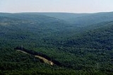
The topography
of Taum Sauk is that of a somewhat flat ridge rather than a peak.
While not as impressive at 1,772 feet (540 m) as other peaks, Taum Sauk and the St. Francois range are true mountain
s, being the result of a volcanic
orogeny
. Whereas vertical relief in the rest of the Ozarks region is the result of erosion
of sedimentary strata
, the St. Francois are an ancient Precambrian
igneous uplift several times older than the Appalachians
. Geologists believe that Taum Sauk and its neighbors may be among the few areas in the US never to have been submerged in ancient seas. The peaks of the St. Francois range existed as islands in the shallow seaway throughout most of the Paleozoic
Era as the sandstone
s, limestone
s, and shale
s typical of the Ozarks were deposited. Weathering
and erosion
of these ancient peaks provided the clastic sediment
s of the surrounding rock layers
.
Taum Sauk is said to be named for a Piankeshaw
chief named Sauk-Ton-Qua.
Although Taum Sauk Mountain is the highest mountain in Missouri at 1,772 feet above sea level, Taum Sauk is not the tallest Mountain from base to summit. Taum Sauk rises from an an already elevated plain. The tallest mountain in Missouri is Black Mountain. Although Black Mountain is only the 42nd highest mountain in terms of elevation above sea level, it rises from the St. Francis River running at its base, at approximately 540 feet above sea level, to a summit of 1,506 feet. Black Mountain rises just under 1,000 feet, while Taum Sauk rises approximately 700 feet.
Taum Sauk is the highest mountain in Missouri. Black Mountain is the tallest mountain in Missouri.
, a 7448 acres (30.1 km²) state park
on the mountain: it has a rustic campground, a paved trail to the highpoint marked by a polished granite plaque, and a lookout tower from which a good view can be had; the dense forest on the mountain obscures the view from most other vantage points. Taum Sauk State Park is in a common jurisdiction with nearby Johnson's Shut-ins State Park
, and together they comprise the second largest state park in Missouri with a total area of 15961.5 acres (64.6 km²). These parks and the adjacent Bell Mountain Wilderness Area
make up part of a large wilderness area that is very popular with hikers
and backpackers
. The 33 miles (53.1 km) Taum Sauk section of the Ozark Trail
is considered by the Ozark Trail Association to be one of the finest trails in Missouri.
Mina Sauk Falls, the highest waterfall in Missouri, is on Taum Sauk and can be visited by hiking a rugged trail that makes a 3 miles (4.8 km) loop from the highpoint parking area. These falls normally have water cascading over them only during times of wet weather. At other times they are reduced to a trickle or less.
The Taum Sauk pumped storage plant
, which failed on December 14, 2005 sending a flash flood 20 feet (6 m) deep down the Black River
, is not actually on Taum Sauk Mountain. It is on Proffit Mountain, about five miles (8 km) southwest.
Saint Francois Mountains
The St. Francois Mountains in southeast Missouri are a range of Precambrian igneous mountains rising over the Ozark Plateau. This range is one of the oldest exposures of igneous rock in North America....
is the highest natural point in the U.S. state
U.S. state
A U.S. state is any one of the 50 federated states of the United States of America that share sovereignty with the federal government. Because of this shared sovereignty, an American is a citizen both of the federal entity and of his or her state of domicile. Four states use the official title of...
of Missouri
Missouri
Missouri is a US state located in the Midwestern United States, bordered by Iowa, Illinois, Kentucky, Tennessee, Arkansas, Oklahoma, Kansas and Nebraska. With a 2010 population of 5,988,927, Missouri is the 18th most populous state in the nation and the fifth most populous in the Midwest. It...
, 1,772 feet (540 m) above mean sea level
Sea level
Mean sea level is a measure of the average height of the ocean's surface ; used as a standard in reckoning land elevation...
.
The topography
Topography
Topography is the study of Earth's surface shape and features or those ofplanets, moons, and asteroids...
of Taum Sauk is that of a somewhat flat ridge rather than a peak.
While not as impressive at 1,772 feet (540 m) as other peaks, Taum Sauk and the St. Francois range are true mountain
Mountain
Image:Himalaya_annotated.jpg|thumb|right|The Himalayan mountain range with Mount Everestrect 58 14 160 49 Chomo Lonzorect 200 28 335 52 Makalurect 378 24 566 45 Mount Everestrect 188 581 920 656 Tibetan Plateaurect 250 406 340 427 Rong River...
s, being the result of a volcanic
Volcano
2. Bedrock3. Conduit 4. Base5. Sill6. Dike7. Layers of ash emitted by the volcano8. Flank| 9. Layers of lava emitted by the volcano10. Throat11. Parasitic cone12. Lava flow13. Vent14. Crater15...
orogeny
Orogeny
Orogeny refers to forces and events leading to a severe structural deformation of the Earth's crust due to the engagement of tectonic plates. Response to such engagement results in the formation of long tracts of highly deformed rock called orogens or orogenic belts...
. Whereas vertical relief in the rest of the Ozarks region is the result of erosion
Dissected plateau
A dissected plateau is a plateau area that has been severely eroded so that the relief is sharp. Such an area may be referred to as mountainous, but dissected plateaus are distinguishable from orogenic mountain belts by the lack of folding, metamorphism, extensive faulting, or magmatic activity...
of sedimentary strata
Stratum
In geology and related fields, a stratum is a layer of sedimentary rock or soil with internally consistent characteristics that distinguish it from other layers...
, the St. Francois are an ancient Precambrian
Precambrian
The Precambrian is the name which describes the large span of time in Earth's history before the current Phanerozoic Eon, and is a Supereon divided into several eons of the geologic time scale...
igneous uplift several times older than the Appalachians
Appalachian Mountains
The Appalachian Mountains #Whether the stressed vowel is or ,#Whether the "ch" is pronounced as a fricative or an affricate , and#Whether the final vowel is the monophthong or the diphthong .), often called the Appalachians, are a system of mountains in eastern North America. The Appalachians...
. Geologists believe that Taum Sauk and its neighbors may be among the few areas in the US never to have been submerged in ancient seas. The peaks of the St. Francois range existed as islands in the shallow seaway throughout most of the Paleozoic
Paleozoic
The Paleozoic era is the earliest of three geologic eras of the Phanerozoic eon, spanning from roughly...
Era as the sandstone
Sandstone
Sandstone is a sedimentary rock composed mainly of sand-sized minerals or rock grains.Most sandstone is composed of quartz and/or feldspar because these are the most common minerals in the Earth's crust. Like sand, sandstone may be any colour, but the most common colours are tan, brown, yellow,...
s, limestone
Limestone
Limestone is a sedimentary rock composed largely of the minerals calcite and aragonite, which are different crystal forms of calcium carbonate . Many limestones are composed from skeletal fragments of marine organisms such as coral or foraminifera....
s, and shale
Shale
Shale is a fine-grained, clastic sedimentary rock composed of mud that is a mix of flakes of clay minerals and tiny fragments of other minerals, especially quartz and calcite. The ratio of clay to other minerals is variable. Shale is characterized by breaks along thin laminae or parallel layering...
s typical of the Ozarks were deposited. Weathering
Weathering
Weathering is the breaking down of rocks, soils and minerals as well as artificial materials through contact with the Earth's atmosphere, biota and waters...
and erosion
Erosion
Erosion is when materials are removed from the surface and changed into something else. It only works by hydraulic actions and transport of solids in the natural environment, and leads to the deposition of these materials elsewhere...
of these ancient peaks provided the clastic sediment
Sediment
Sediment is naturally occurring material that is broken down by processes of weathering and erosion, and is subsequently transported by the action of fluids such as wind, water, or ice, and/or by the force of gravity acting on the particle itself....
s of the surrounding rock layers
Stratum
In geology and related fields, a stratum is a layer of sedimentary rock or soil with internally consistent characteristics that distinguish it from other layers...
.
Taum Sauk is said to be named for a Piankeshaw
Piankeshaw
The Piankeshaw Indians were Native Americans, and members of the Miami Indians who lived apart from the rest of the Miami nation. They lived in an area that now includes western Indiana and Ohio, and were closely allied with the Wea Indians...
chief named Sauk-Ton-Qua.
Although Taum Sauk Mountain is the highest mountain in Missouri at 1,772 feet above sea level, Taum Sauk is not the tallest Mountain from base to summit. Taum Sauk rises from an an already elevated plain. The tallest mountain in Missouri is Black Mountain. Although Black Mountain is only the 42nd highest mountain in terms of elevation above sea level, it rises from the St. Francis River running at its base, at approximately 540 feet above sea level, to a summit of 1,506 feet. Black Mountain rises just under 1,000 feet, while Taum Sauk rises approximately 700 feet.
Taum Sauk is the highest mountain in Missouri. Black Mountain is the tallest mountain in Missouri.
State park
In 1991 Missouri created Taum Sauk Mountain State ParkTaum Sauk Mountain State Park
Taum Sauk Mountain State Park is located in the Saint Francois Mountains in the Missouri Ozarks. It is centered around Taum Sauk Mountain, the highest point in the state....
, a 7448 acres (30.1 km²) state park
State park
State parks are parks or other protected areas managed at the federated state level within those nations which use "state" as a political subdivision. State parks are typically established by a state to preserve a location on account of its natural beauty, historic interest, or recreational...
on the mountain: it has a rustic campground, a paved trail to the highpoint marked by a polished granite plaque, and a lookout tower from which a good view can be had; the dense forest on the mountain obscures the view from most other vantage points. Taum Sauk State Park is in a common jurisdiction with nearby Johnson's Shut-ins State Park
Johnson's Shut-Ins State Park
Johnson's Shut-Ins State Park is a Missouri state park on the East Fork Black River consisting of in Reynolds County. The park is jointly administered with adjoining Taum Sauk Mountain State Park, and together the two parks cover in the St...
, and together they comprise the second largest state park in Missouri with a total area of 15961.5 acres (64.6 km²). These parks and the adjacent Bell Mountain Wilderness Area
Bell Mountain Wilderness
The United States Congress designated the Bell Mountain Wilderness in 1980. The wilderness area now has a total of . Bell Mountain is located within the Potosi-Fredericktown Ranger District of the Mark Twain National Forest, south of Potosi, Missouri in the United States...
make up part of a large wilderness area that is very popular with hikers
Hiking
Hiking is an outdoor activity which consists of walking in natural environments, often in mountainous or other scenic terrain. People often hike on hiking trails. It is such a popular activity that there are numerous hiking organizations worldwide. The health benefits of different types of hiking...
and backpackers
Backpacking (wilderness)
Backpacking combines the activities of hiking and camping for an overnight stay in backcountry wilderness...
. The 33 miles (53.1 km) Taum Sauk section of the Ozark Trail
Ozark Trail (hiking trail)
The Ozark Trail is a hiking, backpacking, and, in many places, biking and equestrian trail under construction in the Missouri Ozarks in the United States. It is intended to reach from St. Louis to Arkansas. Over of the trail have been completed as of 2008, and the estimated length when finished...
is considered by the Ozark Trail Association to be one of the finest trails in Missouri.
Mina Sauk Falls, the highest waterfall in Missouri, is on Taum Sauk and can be visited by hiking a rugged trail that makes a 3 miles (4.8 km) loop from the highpoint parking area. These falls normally have water cascading over them only during times of wet weather. At other times they are reduced to a trickle or less.
The Taum Sauk pumped storage plant
Taum Sauk pumped storage plant
The Taum Sauk pumped storage plant is located in the St. Francois mountain region of the Missouri Ozarks approximately south of St. Louis near Lesterville, Missouri in Reynolds County. The pumped-storage hydroelectric plant, operated by the AmerenUE electric company, was designed to help...
, which failed on December 14, 2005 sending a flash flood 20 feet (6 m) deep down the Black River
Black River (Arkansas)
The Black River is a tributary of the White River, about 300 mi long , in southeastern Missouri and northeastern Arkansas in the United States. Via the White River, it is part of the Mississippi River watershed...
, is not actually on Taum Sauk Mountain. It is on Proffit Mountain, about five miles (8 km) southwest.