

Losing stream
Encyclopedia
A losing stream, or influent stream, is a stream
or river
that loses water as it flows downstream. The water infiltrates
into the ground recharging the local groundwater
, because the water table
is below the bottom of the stream channel. This is the opposite of a more usual gaining stream (or effluent stream) which increases in water volume farther down stream as it gains water from the local aquifer
.
Losing streams are common in arid areashttp://jersey.uoregon.edu/~mstrick/AskGeoMan/geoQuerry62.html. Losing streams are also common in regions of karst topography
where the streamwater may be completely captured by an underground cavern
system, becoming a subterranean river
.
 Examples of losing streams include:
Stream
A stream is a body of water with a current, confined within a bed and stream banks. Depending on its locale or certain characteristics, a stream may be referred to as a branch, brook, beck, burn, creek, "crick", gill , kill, lick, rill, river, syke, bayou, rivulet, streamage, wash, run or...
or river
River
A river is a natural watercourse, usually freshwater, flowing towards an ocean, a lake, a sea, or another river. In a few cases, a river simply flows into the ground or dries up completely before reaching another body of water. Small rivers may also be called by several other names, including...
that loses water as it flows downstream. The water infiltrates
Infiltration (hydrology)
Infiltration is the process by which water on the ground surface enters the soil. Infiltration rate in soil science is a measure of the rate at which soil is able to absorb rainfall or irrigation. It is measured in inches per hour or millimeters per hour. The rate decreases as the soil becomes...
into the ground recharging the local groundwater
Groundwater
Groundwater is water located beneath the ground surface in soil pore spaces and in the fractures of rock formations. A unit of rock or an unconsolidated deposit is called an aquifer when it can yield a usable quantity of water. The depth at which soil pore spaces or fractures and voids in rock...
, because the water table
Water table
The water table is the level at which the submarine pressure is far from atmospheric pressure. It may be conveniently visualized as the 'surface' of the subsurface materials that are saturated with groundwater in a given vicinity. However, saturated conditions may extend above the water table as...
is below the bottom of the stream channel. This is the opposite of a more usual gaining stream (or effluent stream) which increases in water volume farther down stream as it gains water from the local aquifer
Aquifer
An aquifer is a wet underground layer of water-bearing permeable rock or unconsolidated materials from which groundwater can be usefully extracted using a water well. The study of water flow in aquifers and the characterization of aquifers is called hydrogeology...
.
Losing streams are common in arid areashttp://jersey.uoregon.edu/~mstrick/AskGeoMan/geoQuerry62.html. Losing streams are also common in regions of karst topography
Karst topography
Karst topography is a geologic formation shaped by the dissolution of a layer or layers of soluble bedrock, usually carbonate rock such as limestone or dolomite, but has also been documented for weathering resistant rocks like quartzite given the right conditions.Due to subterranean drainage, there...
where the streamwater may be completely captured by an underground cavern
Cave
A cave or cavern is a natural underground space large enough for a human to enter. The term applies to natural cavities some part of which is in total darkness. The word cave also includes smaller spaces like rock shelters, sea caves, and grottos.Speleology is the science of exploration and study...
system, becoming a subterranean river
Subterranean river
A subterranean river is a river that runs wholly or partly beneath the ground surface – one where the riverbed does not represent the surface of the Earth ....
.
Examples of losing streams
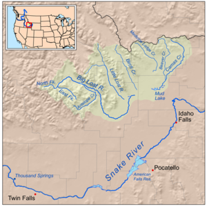
- There are two rivers in Idaho, the Big Lost River and the Little Lost RiverLost River (Idaho)There are two rivers in Idaho named "Lost", the Big Lost River and the Little Lost River. They are often considered separate streams, but both flow into the same depression and become subterranean, feeding the Snake River Plain Aquifer. The rivers are located in Custer County and Butte County, in...
, which both flow into the same depression and become subterranean, feeding the Snake River Plain Aquifer. Via the aquiferAquiferAn aquifer is a wet underground layer of water-bearing permeable rock or unconsolidated materials from which groundwater can be usefully extracted using a water well. The study of water flow in aquifers and the characterization of aquifers is called hydrogeology...
and numerous springsSpring (hydrosphere)A spring—also known as a rising or resurgence—is a component of the hydrosphere. Specifically, it is any natural situation where water flows to the surface of the earth from underground...
, they are tributaries of the Snake RiverSnake RiverThe Snake is a major river of the greater Pacific Northwest in the United States. At long, it is the largest tributary of the Columbia River, the largest North American river that empties into the Pacific Ocean...
. - The Lost River in IndianaLost River (Indiana)The Lost River is a river that rises in Vernon Township, Washington County, Indiana, and discharges into the East Fork of the White River in Lost River Township, Martin County, Indiana...
rises in Vernon Township, Washington County, IndianaVernon Township, Washington County, IndianaVernon Township is one of thirteen townships in Washington County, Indiana, USA. As of the 2000 census, its population was 684.-Geography:According to the United States Census Bureau, Vernon Township covers an area of ; of this, is land and is water.-Unincorporated towns:* Claysville at *...
, and discharges into the East Fork of the White RiverWhite River (Indiana)The White River is a two-forked river that flows through central and southern Indiana and is the main tributary to the Wabash River. Via the west fork, considered to be the main stem of the river by the U.S. Board on Geographic Names, the White River is long.-West Fork:The West Fork, long, is...
. The Lost River is about 85 miles (136.8 km) long and its name is derived from the fact that at least 23 miles (37 km) of the primary course of the river flows completely underground. The river disappears into a series of sink holes of the type that are abundant in the karstKARSTKilometer-square Area Radio Synthesis Telescope is a Chinese telescope project to which FAST is a forerunner. KARST is a set of large spherical reflectors on karst landforms, which are bowlshaped limestone sinkholes named after the Kras region in Slovenia and Northern Italy. It will consist of...
land of southern IndianaSouthern IndianaSouthern Indiana, in the United States, consists of the 33 counties located in the southernmost part of the state. The region's history and geography has led to a blend of Northern and Southern culture distinct from the remainder of Indiana. It is often considered to be part of the Upland South...
. - The Lost River of New HampshireLost River (New Hampshire)The Lost River is a stream located in the White Mountains of New Hampshire in the United States. It is a tributary of the Pemigewasset River, part of the Merrimack River watershed....
is a 6.5 miles (10.5 km) long streamStreamA stream is a body of water with a current, confined within a bed and stream banks. Depending on its locale or certain characteristics, a stream may be referred to as a branch, brook, beck, burn, creek, "crick", gill , kill, lick, rill, river, syke, bayou, rivulet, streamage, wash, run or...
located in the White MountainsWhite Mountains (New Hampshire)The White Mountains are a mountain range covering about a quarter of the state of New Hampshire and a small portion of western Maine in the United States. Part of the Appalachian Mountains, they are considered the most rugged mountains in New England...
of New HampshireNew HampshireNew Hampshire is a state in the New England region of the northeastern United States of America. The state was named after the southern English county of Hampshire. It is bordered by Massachusetts to the south, Vermont to the west, Maine and the Atlantic Ocean to the east, and the Canadian...
in the United StatesUnited StatesThe United States of America is a federal constitutional republic comprising fifty states and a federal district...
. It is a tributaryTributaryA tributary or affluent is a stream or river that flows into a main stem river or a lake. A tributary does not flow directly into a sea or ocean...
of the Pemigewasset RiverPemigewasset RiverThe Pemigewasset River , known locally as "The Pemi", is a river in the state of New Hampshire, the United States. It is in length and drains approximately...
, part of the Merrimack RiverMerrimack RiverThe Merrimack River is a river in the northeastern United States. It rises at the confluence of the Pemigewasset and Winnipesaukee rivers in Franklin, New Hampshire, flows southward into Massachusetts, and then flows northeast until it empties into the Atlantic Ocean at Newburyport...
watershedDrainage basinA drainage basin is an extent or an area of land where surface water from rain and melting snow or ice converges to a single point, usually the exit of the basin, where the waters join another waterbody, such as a river, lake, reservoir, estuary, wetland, sea, or ocean...
. The Lost River begins in Kinsman NotchKinsman NotchKinsman Notch is a mountain pass located in the White Mountains of New Hampshire, United States. It is the westernmost of the major notches through the White Mountains...
, one of the major passesMountain passA mountain pass is a route through a mountain range or over a ridge. If following the lowest possible route, a pass is locally the highest point on that route...
through the White Mountains. As it flows through the notch, it passes through Lost River GorgeLost River ReservationThe Lost River Reservation is a series of caves in the White Mountains in Woodstock, New Hampshire, United States. Located west of the village of North Woodstock on New Hampshire Route 112, Lost River Reservation is set in Kinsman Notch...
, an area where enormous boulders falling off the flanking walls of the notch at the close of the last Ice AgeIce ageAn ice age or, more precisely, glacial age, is a generic geological period of long-term reduction in the temperature of the Earth's surface and atmosphere, resulting in the presence or expansion of continental ice sheets, polar ice sheets and alpine glaciers...
have covered the river, creating a network of boulder caves. - The Lost River of West VirginiaLost River (Cacapon River)The Lost River is a river in the Appalachian Mountains of Hardy County in West Virginia's Eastern Panhandle region. The Lost River is geologically the same river as the Cacapon River: it flows into an underground channel northeast of Baker along West Virginia Route 259 at "the Sinks" and reappears...
is located in the Appalachian MountainsAppalachian MountainsThe Appalachian Mountains #Whether the stressed vowel is or ,#Whether the "ch" is pronounced as a fricative or an affricate , and#Whether the final vowel is the monophthong or the diphthong .), often called the Appalachians, are a system of mountains in eastern North America. The Appalachians...
of Hardy CountyHardy County, West VirginiaAs of the census of 2000, there were 12,669 people, 5,204 households, and 3,564 families residing in the county. The population density was 22 people per square mile . There were 7,115 housing units at an average density of 12 per square mile...
in the Eastern Panhandle region of the state. It flows into an underground channel northeast of BakerBaker, West VirginiaBaker is an unincorporated community on the Lost River in Hardy County, West Virginia, United States. Baker is located at the intersection of West Virginia Route 259 and West Virginia Route 55. The ZCTA population for Baker's ZIP Code was 1,262 at the 2000 census....
along West Virginia Route 259 at "the Sinks" and reappears near WardensvilleWardensville, West VirginiaWardensville is a town in Hardy County, West Virginia, United States. The population was 246 at the 2000 census. Originally named Trout Run, Wardensville was chartered in Virginia in 1832 and incorporated in West Virginia in 1879. It is named for the town's first merchant. It is home to Trout...
as the Cacapon RiverCacapon RiverThe Cacapon River , located in the Appalachian Mountains of West Virginia's Eastern Panhandle region, is an river known for its fishing, boating, wildlife, and scenery...
.