

Headward erosion
Encyclopedia

Fluvial
Fluvial is used in geography and Earth science to refer to the processes associated with rivers and streams and the deposits and landforms created by them...
process of erosion
Erosion
Erosion is when materials are removed from the surface and changed into something else. It only works by hydraulic actions and transport of solids in the natural environment, and leads to the deposition of these materials elsewhere...
that lengthens a stream
Stream
A stream is a body of water with a current, confined within a bed and stream banks. Depending on its locale or certain characteristics, a stream may be referred to as a branch, brook, beck, burn, creek, "crick", gill , kill, lick, rill, river, syke, bayou, rivulet, streamage, wash, run or...
, a valley
Valley
In geology, a valley or dale is a depression with predominant extent in one direction. A very deep river valley may be called a canyon or gorge.The terms U-shaped and V-shaped are descriptive terms of geography to characterize the form of valleys...
or a gully
Gully
A gully is a landform created by running water, eroding sharply into soil, typically on a hillside. Gullies resemble large ditches or small valleys, but are metres to tens of metres in depth and width...
at its head
Source (river or stream)
The source or headwaters of a river or stream is the place from which the water in the river or stream originates.-Definition:There is no universally agreed upon definition for determining a stream's source...
and also enlarges its drainage basin
Drainage basin
A drainage basin is an extent or an area of land where surface water from rain and melting snow or ice converges to a single point, usually the exit of the basin, where the waters join another waterbody, such as a river, lake, reservoir, estuary, wetland, sea, or ocean...
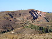
. The stream erodes away at the rock and soil at its headwaters in the opposite direction that it flows. Once a stream has begun to cut back, the erosion is sped up by the steep gradient the water is flowing down. As water erodes a path from its headwaters to its mouth at a standing body of water, it tries to cut an ever-shallower path. This leads to increased erosion at the steepest parts, which is headward erosion. If headward erosion continues long enough, it can cause a stream to break through into a neighboring watershed
Drainage basin
A drainage basin is an extent or an area of land where surface water from rain and melting snow or ice converges to a single point, usually the exit of the basin, where the waters join another waterbody, such as a river, lake, reservoir, estuary, wetland, sea, or ocean...
and capture drainage that previously flowed to another stream.
For example, headward erosion by the Shenandoah River
Shenandoah River
The Shenandoah River is a tributary of the Potomac River, long with two forks approximately long each, in the U.S. states of Virginia and West Virginia...
in the U.S. state of Virginia
Virginia
The Commonwealth of Virginia , is a U.S. state on the Atlantic Coast of the Southern United States. Virginia is nicknamed the "Old Dominion" and sometimes the "Mother of Presidents" after the eight U.S. presidents born there...
, a tributary
Tributary
A tributary or affluent is a stream or river that flows into a main stem river or a lake. A tributary does not flow directly into a sea or ocean...
of the Potomac River
Potomac River
The Potomac River flows into the Chesapeake Bay, located along the mid-Atlantic coast of the United States. The river is approximately long, with a drainage area of about 14,700 square miles...
, permitted the Shenandoah to capture successively the original upstream segments of Beaverdam Creek
Beaverdam Creek
Beaverdam Creek is a Pennsylvania stream near Hunterstown, northeast of Gettysburg, Pennsylvania. The creek's intersection with the road leading to the Gettysburg Railroad's Granite station was the site of the Battle of Hunterstown on July 2, 1863....
, Gap Run and Goose Creek
Goose Creek (Potomac River)
Goose Creek is a tributary of the Potomac River in Fauquier and Loudoun counties in northern Virginia. It comprises the principal drainage system for the Loudoun Valley.-Course:...
, three smaller tributaries of the Potomac. As each capture added to the Shenandoah's discharge
Effluent
Effluent is an outflowing of water or gas from a natural body of water, or from a human-made structure.Effluent is defined by the United States Environmental Protection Agency as “wastewater - treated or untreated - that flows out of a treatment plant, sewer, or industrial outfall. Generally refers...
, it accelerated the process of headward erosion until the Shenandoah captured all drainage to the Potomac west of the Blue Ridge Mountains
Blue Ridge Mountains
The Blue Ridge Mountains are a physiographic province of the larger Appalachian Mountains range. This province consists of northern and southern physiographic regions, which divide near the Roanoke River gap. The mountain range is located in the eastern United States, starting at its southern-most...
.
Stream types created by headward erosion
Three kinds of streams are formed by headward erosion: insequent streams, subsequent streams, and obsequent and resequent streams (See Fluvial landforms of streamsFluvial landforms of streams
The fluvial landforms of streams, stream beds, and river valleys have various landforms.-Classification:*Consequent streams are streams whose course is a direct consequence of the original slope of the surface upon which it developed, i.e., streams that follow slope of the land over which they...
.) Insequent streams form by random headward erosion, usually from sheetflow of water over the landform surface. The water collects in channels where the velocity and erosional power increase, cutting into and extending the heads of gullies. Subsequent streams form by selective headward erosion by cutting away at less resistive rocks in the terrain. Obsequent and resequent streams form after time in an area of insequent or subsequent streams. Obsequent streams are insequent streams that now flow in an opposite direction of the original drainage pattern. Resequent streams are subsequent streams that have also changed direction from their original drainage patterns. (Easterbrook, p. 149)
Drainage patterns created by headward erosion
Headward erosion creates three major kinds of drainage patterns: dendriticDrainage system (Geomorphology)
In geomorphology, a drainage system is the pattern formed by the streams, rivers, and lakes in a particular drainage basin. They are governed by the topography of the land, whether a particular region is dominated by hard or soft rocks, and the gradient of the land. Geomorphologists and...
patterns, trellis
Drainage system (Geomorphology)
In geomorphology, a drainage system is the pattern formed by the streams, rivers, and lakes in a particular drainage basin. They are governed by the topography of the land, whether a particular region is dominated by hard or soft rocks, and the gradient of the land. Geomorphologists and...
patterns and rectangular and angular patterns. Dendritic patterns form in homogenous landforms where the underlying bedrock has no structural control over where the water flows. They have a very characteristic pattern of branching at acute angles with no common or similarly repeating pattern. Trellis patterns form in where the underlying bedrock where there is repeating weaker and stronger types of rock. The trellis pattern cuts down deeper into the weaker bedrock, and is characterized by nearly parallel streams that branch at higher angles. Rectangular and angular patterns are characterized by branching of tributaries at nearly right angles and tributaries which themselves exhibit right-angle bends in their channels. These usually form in jointed igneous bedrocks, horizontal sedimentary beds with well-developed jointing or intersecting faults. (Easterbrook, p. 149-150)
Four minor kinds of drainage patterns also can be created: radial patterns, annular patterns, centripetal
Centripetal force
Centripetal force is a force that makes a body follow a curved path: it is always directed orthogonal to the velocity of the body, toward the instantaneous center of curvature of the path. The mathematical description was derived in 1659 by Dutch physicist Christiaan Huygens...
patterns and parallel patterns. Radial patterns are characterized by flow of water outward from a central point, such as down a newly formed cinder volcano cone or an intrusive domes. Annular patterns form on domes of alternating weak and hard bedrocks. The pattern formed is similar to that of a bullseye
Bullseye (target)
The bullseye, or bull's-eye, is the centre of a target , and by extension the name given to any shot that hits the bullseye...
when viewed from above, as the weaker bedrocks are eroded and the harder are left in place. Centripetal patterns form where water flows into a central location, such as in a karst
Karst topography
Karst topography is a geologic formation shaped by the dissolution of a layer or layers of soluble bedrock, usually carbonate rock such as limestone or dolomite, but has also been documented for weathering resistant rocks like quartzite given the right conditions.Due to subterranean drainage, there...
limestone terrain where the water flows down into a sinkhole
Sinkhole
A sinkhole, also known as a sink, shake hole, swallow hole, swallet, doline or cenote, is a natural depression or hole in the Earth's surface caused by karst processes — the chemical dissolution of carbonate rocks or suffosion processes for example in sandstone...
and then underground. Parallel patterns are not very common and form on unidirectional regional slope or parallel landform features. They are usually limited to a small, generalized area. (Easterbrook, p. 152)