

Faiyum Oasis
Encyclopedia
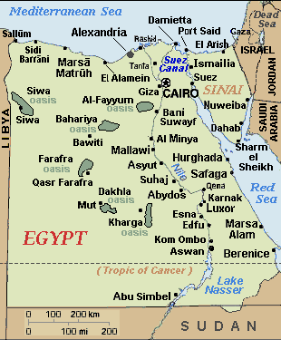
Cairo
Cairo , is the capital of Egypt and the largest city in the Arab world and Africa, and the 16th largest metropolitan area in the world. Nicknamed "The City of a Thousand Minarets" for its preponderance of Islamic architecture, Cairo has long been a centre of the region's political and cultural life...
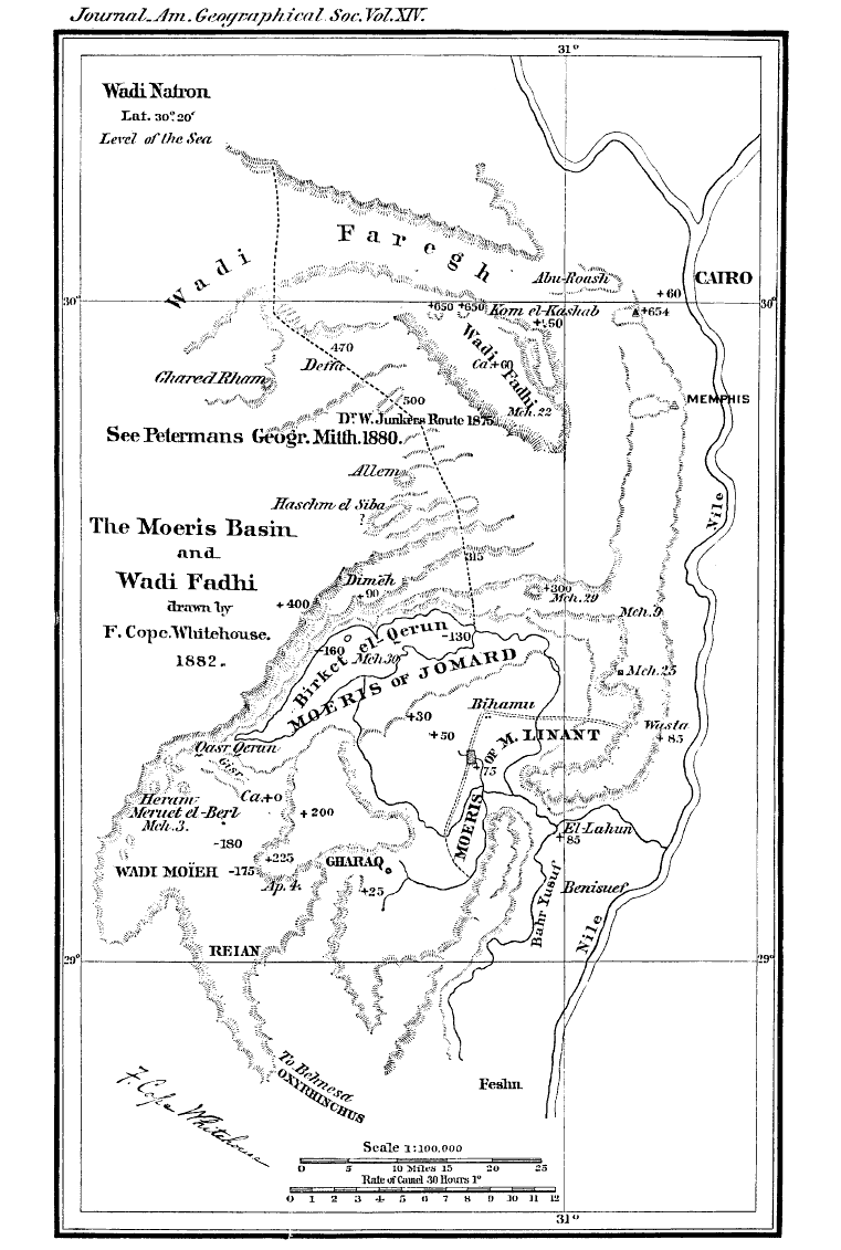
. The extent of the basin area is estimated at between 490 mi² (1,270 km²) and 656 mi² (1700 km²). The basin floor comprises fields watered by a channel of the Nile
Nile
The Nile is a major north-flowing river in North Africa, generally regarded as the longest river in the world. It is long. It runs through the ten countries of Sudan, South Sudan, Burundi, Rwanda, Democratic Republic of the Congo, Tanzania, Kenya, Ethiopia, Uganda and Egypt.The Nile has two major...
, the Bahr Yussef
Bahr Yussef
The Bahr Yussef, which roughly translates from Arabic as "the waterway of Joseph", is a canal which connects the Nile River with Fayyum in Egypt. This was originally in prehistoric times a natural offshoot of the Nile which created a lake to the west during high floods. Beginning with the 12th...
, as it drains into a desert depression to the west of the Nile Valley. The Bahr Yussef veers west through a narrow neck of land north of Ihnasya, between the archaeological sites of El-Lahun
El-Lahun
Located in the Faiyum, Egypt, el-Lahun or Kahun is the workers' village associated with the pyramid of Senusret II . It is located near the modern village of el-Lahun , and is often known by that name...
and Gurob near Hawara
Hawara
Hawara is an archaeological site of Ancient Egypt, south of the site of Crocodilopolis at the entrance to the depression of the Fayyum oasis. The first excavations at the site were made by Karl Lepsius, in 1843...
; it then branches out, providing rich agricultural land in the Faiyum basin, draining into the large saltwater Lake Moeris
Lake Moeris
Lake Moeris is an ancient lake in the northwest of the Faiyum Oasis, southwest of Cairo, Egypt. It persists in modern times as a smaller lake called Birket Qarun. The lake's surface is 140 ft below sea-level, and covers about ....
(Birket Qarun). The lake was freshwater in prehistory but is today a saltwater lake. It is a source for tilapia
Tilapia
Tilapia , is the common name for nearly a hundred species of cichlid fish from the tilapiine cichlid tribe. Tilapia inhabit a variety of fresh water habitats, including shallow streams, ponds, rivers and lakes. Historically, they have been of major importance in artisan fishing in Africa and the...
and other fish for the local area.
Differing from typical oasis
Oasis
In geography, an oasis or cienega is an isolated area of vegetation in a desert, typically surrounding a spring or similar water source...
, whose fertility depends on water obtained from springs, the cultivated land in the Faiyum is formed of Nile
Nile
The Nile is a major north-flowing river in North Africa, generally regarded as the longest river in the world. It is long. It runs through the ten countries of Sudan, South Sudan, Burundi, Rwanda, Democratic Republic of the Congo, Tanzania, Kenya, Ethiopia, Uganda and Egypt.The Nile has two major...
mud brought down by the Bahr Yussef, 15 miles (24 km) in length. Between the beginning of Bahr Yussef at El-Lahun
El-Lahun
Located in the Faiyum, Egypt, el-Lahun or Kahun is the workers' village associated with the pyramid of Senusret II . It is located near the modern village of el-Lahun , and is often known by that name...
to its end at the city of Faiyum, several canals branch off to irrigate the Faiyum Governorate. The drainage water flows into Lake Moeris
Lake Moeris
Lake Moeris is an ancient lake in the northwest of the Faiyum Oasis, southwest of Cairo, Egypt. It persists in modern times as a smaller lake called Birket Qarun. The lake's surface is 140 ft below sea-level, and covers about ....
.
Over 400 mile² (1,000 km²) of the Faiyum Oasis is cultivated, the chief crops being cereal
Cereal
Cereals are grasses cultivated for the edible components of their grain , composed of the endosperm, germ, and bran...
s and cotton
Cotton
Cotton is a soft, fluffy staple fiber that grows in a boll, or protective capsule, around the seeds of cotton plants of the genus Gossypium. The fiber is almost pure cellulose. The botanical purpose of cotton fiber is to aid in seed dispersal....
. The completion of the Aswan Low Dam
Aswan Low Dam
The Aswan Low Dam or Old Aswan Dam is a gravity masonry buttress dam on the Nile River in Aswan, Egypt. The dam was built at the former first cataract of the Nile, and is located about 1000 km up-river and 690 km south-southeast of Cairo...
ensured a fuller supply of water, which enabled 20,000 acres (80 km²) of land, previously unirrigated and untaxed, to be brought under cultivation in the three years 1903-1905. Three crops are obtained in twenty months. The province is noted for its fig
Ficus
Ficus is a genus of about 850 species of woody trees, shrubs, vines, epiphytes, and hemiepiphyte in the family Moraceae. Collectively known as fig trees or figs, they are native throughout the tropics with a few species extending into the semi-warm temperate zone. The Common Fig Ficus is a genus of...
s and grape
Grape
A grape is a non-climacteric fruit, specifically a berry, that grows on the perennial and deciduous woody vines of the genus Vitis. Grapes can be eaten raw or they can be used for making jam, juice, jelly, vinegar, wine, grape seed extracts, raisins, molasses and grape seed oil. Grapes are also...
s of exceptional quality. Olive
Olive
The olive , Olea europaea), is a species of a small tree in the family Oleaceae, native to the coastal areas of the eastern Mediterranean Basin as well as northern Iran at the south end of the Caspian Sea.Its fruit, also called the olive, is of major agricultural importance in the...
s are also cultivated. Rose
Rose
A rose is a woody perennial of the genus Rosa, within the family Rosaceae. There are over 100 species. They form a group of erect shrubs, and climbing or trailing plants, with stems that are often armed with sharp prickles. Flowers are large and showy, in colours ranging from white through yellows...
trees are very numerous, and most of the attar of roses
Rose oil
Rose oil, meaning either rose otto or rose absolute, is the essential oil extracted from the petals of various types of rose...
of Egypt is manufactured in the province. Faiyum also possesses an excellent breed of sheep.
History
Mediterranean Sea
The Mediterranean Sea is a sea connected to the Atlantic Ocean surrounded by the Mediterranean region and almost completely enclosed by land: on the north by Anatolia and Europe, on the south by North Africa, and on the east by the Levant...
was a hot dry hollow near the end of the Messinian Salinity Crisis
Messinian salinity crisis
The Messinian Salinity Crisis, also referred to as the Messinian Event, and in its latest stage as the Lago Mare event, was a geological event during which the Mediterranean Sea went into a cycle of partly or nearly complete desiccation throughout the latter part of the Messinian age of the Miocene...
in the late Miocene
Miocene
The Miocene is a geological epoch of the Neogene Period and extends from about . The Miocene was named by Sir Charles Lyell. Its name comes from the Greek words and and means "less recent" because it has 18% fewer modern sea invertebrates than the Pliocene. The Miocene follows the Oligocene...
, Faiyum was a dry hollow, and the Nile
Nile
The Nile is a major north-flowing river in North Africa, generally regarded as the longest river in the world. It is long. It runs through the ten countries of Sudan, South Sudan, Burundi, Rwanda, Democratic Republic of the Congo, Tanzania, Kenya, Ethiopia, Uganda and Egypt.The Nile has two major...
flowed past it at the bottom of a canyon
Canyon
A canyon or gorge is a deep ravine between cliffs often carved from the landscape by a river. Rivers have a natural tendency to reach a baseline elevation, which is the same elevation as the body of water it will eventually drain into. This forms a canyon. Most canyons were formed by a process of...
(which was 8000 feet deep or more (where Cairo
Cairo
Cairo , is the capital of Egypt and the largest city in the Arab world and Africa, and the 16th largest metropolitan area in the world. Nicknamed "The City of a Thousand Minarets" for its preponderance of Islamic architecture, Cairo has long been a centre of the region's political and cultural life...
is today). After the Mediterranean reflooded at the end of the Miocene
Miocene
The Miocene is a geological epoch of the Neogene Period and extends from about . The Miocene was named by Sir Charles Lyell. Its name comes from the Greek words and and means "less recent" because it has 18% fewer modern sea invertebrates than the Pliocene. The Miocene follows the Oligocene...
, the Nile
Nile
The Nile is a major north-flowing river in North Africa, generally regarded as the longest river in the world. It is long. It runs through the ten countries of Sudan, South Sudan, Burundi, Rwanda, Democratic Republic of the Congo, Tanzania, Kenya, Ethiopia, Uganda and Egypt.The Nile has two major...
canyon became an arm of the sea reaching inland further than Aswan
Aswan
Aswan , formerly spelled Assuan, is a city in the south of Egypt, the capital of the Aswan Governorate.It stands on the east bank of the Nile at the first cataract and is a busy market and tourist centre...
. Over geological time that sea arm gradually filled with silt and became the Nile valley.
Eventually the Nile valley bed silted up high enough to let the Nile
Nile
The Nile is a major north-flowing river in North Africa, generally regarded as the longest river in the world. It is long. It runs through the ten countries of Sudan, South Sudan, Burundi, Rwanda, Democratic Republic of the Congo, Tanzania, Kenya, Ethiopia, Uganda and Egypt.The Nile has two major...
in flood overflow into the Faiyum hollow and make a lake in it. The lake is first recorded from about 3000 BC, around the time of Menes
Menes
Menes was an ancient Egyptian pharaoh of the early dynastic period, credited by classical tradition with having united Upper and Lower Egypt, and as the founder of the first dynasty ....
(Narmer). However, for the most part it would only be filled with high flood waters. The lake was bordered by neolithic
Neolithic
The Neolithic Age, Era, or Period, or New Stone Age, was a period in the development of human technology, beginning about 9500 BC in some parts of the Middle East, and later in other parts of the world. It is traditionally considered as the last part of the Stone Age...
settlements, and the town of Crocodilopolis
Crocodilopolis
Crocodilopolis or Krokodilopolis or Ptolemais Euergetis or Arsinoe or Krialon was an ancient city in the Heptanomis, Egypt, the capital of Arsinoites nome, on the western bank of the Nile, between the river and the Lake Moeris, southwest of Memphis, in lat. 29° N...
grew up on the south where the higher ground created a ridge.
In 2300 BC, the waterway from the Nile
Nile
The Nile is a major north-flowing river in North Africa, generally regarded as the longest river in the world. It is long. It runs through the ten countries of Sudan, South Sudan, Burundi, Rwanda, Democratic Republic of the Congo, Tanzania, Kenya, Ethiopia, Uganda and Egypt.The Nile has two major...
to the natural lake was widened and deepened to make a canal which is now known as the Bahr Yussef
Bahr Yussef
The Bahr Yussef, which roughly translates from Arabic as "the waterway of Joseph", is a canal which connects the Nile River with Fayyum in Egypt. This was originally in prehistoric times a natural offshoot of the Nile which created a lake to the west during high floods. Beginning with the 12th...
. This canal fed into the lake. This was meant to serve three purposes: control the flooding of the Nile
Nile
The Nile is a major north-flowing river in North Africa, generally regarded as the longest river in the world. It is long. It runs through the ten countries of Sudan, South Sudan, Burundi, Rwanda, Democratic Republic of the Congo, Tanzania, Kenya, Ethiopia, Uganda and Egypt.The Nile has two major...
, regulate the water level of the Nile
Nile
The Nile is a major north-flowing river in North Africa, generally regarded as the longest river in the world. It is long. It runs through the ten countries of Sudan, South Sudan, Burundi, Rwanda, Democratic Republic of the Congo, Tanzania, Kenya, Ethiopia, Uganda and Egypt.The Nile has two major...
during dry seasons, and serve the surrounding area with irrigation. There is evidence of ancient Egypt
Ancient Egypt
Ancient Egypt was an ancient civilization of Northeastern Africa, concentrated along the lower reaches of the Nile River in what is now the modern country of Egypt. Egyptian civilization coalesced around 3150 BC with the political unification of Upper and Lower Egypt under the first pharaoh...
ian pharaoh
Pharaoh
Pharaoh is a title used in many modern discussions of the ancient Egyptian rulers of all periods. The title originates in the term "pr-aa" which means "great house" and describes the royal palace...
s of the twelfth dynasty
Twelfth dynasty of Egypt
The twelfth dynasty of ancient Egypt is often combined with Dynasties XI, XIII and XIV under the group title Middle Kingdom.-Rulers:Known rulers of the twelfth dynasty are as follows :...
using the natural lake of Faiyum as a reservoir to store surpluses of water for use during the dry periods. The immense waterworks undertaken by the ancient Egypt
Ancient Egypt
Ancient Egypt was an ancient civilization of Northeastern Africa, concentrated along the lower reaches of the Nile River in what is now the modern country of Egypt. Egyptian civilization coalesced around 3150 BC with the political unification of Upper and Lower Egypt under the first pharaoh...
ian pharaoh
Pharaoh
Pharaoh is a title used in many modern discussions of the ancient Egyptian rulers of all periods. The title originates in the term "pr-aa" which means "great house" and describes the royal palace...
s of the twelfth dynasty
Twelfth dynasty of Egypt
The twelfth dynasty of ancient Egypt is often combined with Dynasties XI, XIII and XIV under the group title Middle Kingdom.-Rulers:Known rulers of the twelfth dynasty are as follows :...
to transform the lake into a huge water reservoir gave the impression that the lake itself was an artificial excavation, as reported by classic geographers and travellers. The lake was eventually abandoned due to the nearest branch of the Nile dwindling in size from 230 BC
230 BC
Year 230 BC was a year of the pre-Julian Roman calendar. At the time it was known as the Year of the Consulship of Barbula and Pera...
.
Nome (Egypt)
A nome was a subnational administrative division of ancient Egypt. Today's use of the Greek nome rather than the Egyptian term sepat came about during the Ptolemaic period. Fascinated with Egypt, Greeks created many historical records about the country...
of Upper Egypt
Upper Egypt
Upper Egypt is the strip of land, on both sides of the Nile valley, that extends from the cataract boundaries of modern-day Aswan north to the area between El-Ayait and Zawyet Dahshur . The northern section of Upper Egypt, between El-Ayait and Sohag is sometimes known as Middle Egypt...
, Atef-Pehu ("Northern Sycamore"). In ancient Egypt
Ancient Egypt
Ancient Egypt was an ancient civilization of Northeastern Africa, concentrated along the lower reaches of the Nile River in what is now the modern country of Egypt. Egyptian civilization coalesced around 3150 BC with the political unification of Upper and Lower Egypt under the first pharaoh...
ian times, its capital was Sh-d-y-t (usually written "Shedyt"), called by the Greeks Crocodilopolis
Crocodilopolis
Crocodilopolis or Krokodilopolis or Ptolemais Euergetis or Arsinoe or Krialon was an ancient city in the Heptanomis, Egypt, the capital of Arsinoites nome, on the western bank of the Nile, between the river and the Lake Moeris, southwest of Memphis, in lat. 29° N...
, and refounded by Ptolemy II as Arsinoe
Arsinoe
Arsinoe , sometimes spelled Arsinoë, pronounced Arsinoi in modern Greek, may refer to:-Literature:* Arsinoe, a character in Le Misanthrope, a play by French playwright Molière...
.
This region has the earliest evidence for farming in Egypt
Egypt
Egypt , officially the Arab Republic of Egypt, Arabic: , is a country mainly in North Africa, with the Sinai Peninsula forming a land bridge in Southwest Asia. Egypt is thus a transcontinental country, and a major power in Africa, the Mediterranean Basin, the Middle East and the Muslim world...
, and was a center of royal pyramid and tomb-building in the Twelfth dynasty
Twelfth dynasty of Egypt
The twelfth dynasty of ancient Egypt is often combined with Dynasties XI, XIII and XIV under the group title Middle Kingdom.-Rulers:Known rulers of the twelfth dynasty are as follows :...
of the Middle Kingdom
Middle Kingdom of Egypt
The Middle Kingdom of Egypt is the period in the history of ancient Egypt stretching from the establishment of the Eleventh Dynasty to the end of the Fourteenth Dynasty, between 2055 BC and 1650 BC, although some writers include the Thirteenth and Fourteenth dynasties in the Second Intermediate...
, and again during the rule of the Ptolemaic dynasty
Ptolemaic dynasty
The Ptolemaic dynasty, was a Macedonian Greek royal family which ruled the Ptolemaic Empire in Egypt during the Hellenistic period. Their rule lasted for 275 years, from 305 BC to 30 BC...
. Faiyum became one of the breadbaskets of the Roman world
Roman Empire
The Roman Empire was the post-Republican period of the ancient Roman civilization, characterised by an autocratic form of government and large territorial holdings in Europe and around the Mediterranean....
.
For the first three centuries AD, the people of Faiyum and elsewhere in Roman Egypt not only embalmed their dead but also placed a portrait of the deceased over the face of the mummy wrappings, shroud or case. The Egyptians continued their practice of burying their dead, despite the Roman preference for cremation
Cremation
Cremation is the process of reducing bodies to basic chemical compounds such as gasses and bone fragments. This is accomplished through high-temperature burning, vaporization and oxidation....
. Preserved by the dry desert environment, these Faiyum portraits make up the richest body of portraiture to have survived from antiquity. They provide us with a window into a remarkable society of peoples of mixed origins —Egyptians, Greeks, Romans, Syrians, Libyans and others — that flourished 2,000 years ago in Faiyum. The Faiyum portraits were painted on wood in a pigmented wax
Wax
thumb|right|[[Cetyl palmitate]], a typical wax ester.Wax refers to a class of chemical compounds that are plastic near ambient temperatures. Characteristically, they melt above 45 °C to give a low viscosity liquid. Waxes are insoluble in water but soluble in organic, nonpolar solvents...
technique called encaustic
Encaustic
Encaustic may refer to:*Encaustic painting*Encaustic tile...
.
In the late first millennium AD, the arable area shrank, and settlements around the edge of the basin were abandoned. These sites include some of the best-preserved from the late Roman Empire
Roman Empire
The Roman Empire was the post-Republican period of the ancient Roman civilization, characterised by an autocratic form of government and large territorial holdings in Europe and around the Mediterranean....
, notably Karanis
Karanis
Karanis , located in modern Kom Aushim, was an agricultural town in Graeco-Roman Egypt,located in the northeast corner of the Fayum."It was one of a number of towns established in the Arsinoite nome under Ptolemy II Philadelphus as part of a scheme to settle Greek mercenaries among the indigenous...
, and from the Byzantine
Byzantine Empire
The Byzantine Empire was the Eastern Roman Empire during the periods of Late Antiquity and the Middle Ages, centred on the capital of Constantinople. Known simply as the Roman Empire or Romania to its inhabitants and neighbours, the Empire was the direct continuation of the Ancient Roman State...
and early Arab
Arab
Arab people, also known as Arabs , are a panethnicity primarily living in the Arab world, which is located in Western Asia and North Africa. They are identified as such on one or more of genealogical, linguistic, or cultural grounds, with tribal affiliations, and intra-tribal relationships playing...
Periods, though recent redevelopment has greatly reduced the archaeological features.
For late-period Ancient Egyptian names of the Faiyum oasis and places within it, see http://fayum.arts.kuleuven.be/general/name.html . "Colonial-type" village names (villages named after towns elsewhere in Egypt and places outside Egypt) show that much land was brought into cultivation in the Faiyum in the Greek and Roman periods.
Archaeology
There are, especially in the neighborhood of the lake, many ruins of ancient villages and cities. Mounds north of the city of Faiyum mark the site of CrocodilopolisCrocodilopolis
Crocodilopolis or Krokodilopolis or Ptolemais Euergetis or Arsinoe or Krialon was an ancient city in the Heptanomis, Egypt, the capital of Arsinoites nome, on the western bank of the Nile, between the river and the Lake Moeris, southwest of Memphis, in lat. 29° N...
. In January 2008, Egypt's supreme council of antiquities announced the discovery of an ancient city of farmers dating back to 5200 BC. The site, which probably sat at the edge of Faiyum lake at the time, is still largely buried in the sand, although excavations have revealed walls and houses built of terracotta and limestone, along with foundations of ovens and grain stores.
Birket Qarun lake
In the Faiyum oasis is Birket Qarun (ArabicArabic language
Arabic is a name applied to the descendants of the Classical Arabic language of the 6th century AD, used most prominently in the Quran, the Islamic Holy Book...
for Lake of Qarun), which abounds in fish
Fish
Fish are a paraphyletic group of organisms that consist of all gill-bearing aquatic vertebrate animals that lack limbs with digits. Included in this definition are the living hagfish, lampreys, and cartilaginous and bony fish, as well as various extinct related groups...
, notably bulti, of which considerable quantities are sent to Cairo. In ancient times this lake was much larger, and the ancient Greek
Ancient Greek
Ancient Greek is the stage of the Greek language in the periods spanning the times c. 9th–6th centuries BC, , c. 5th–4th centuries BC , and the c. 3rd century BC – 6th century AD of ancient Greece and the ancient world; being predated in the 2nd millennium BC by Mycenaean Greek...
s and Romans
Ancient Rome
Ancient Rome was a thriving civilization that grew on the Italian Peninsula as early as the 8th century BC. Located along the Mediterranean Sea and centered on the city of Rome, it expanded to one of the largest empires in the ancient world....
called it Lake Moeris
Lake Moeris
Lake Moeris is an ancient lake in the northwest of the Faiyum Oasis, southwest of Cairo, Egypt. It persists in modern times as a smaller lake called Birket Qarun. The lake's surface is 140 ft below sea-level, and covers about ....
.
Cities and towns
The Faiyum oasis contains the city of Faiyum. It also comprises several other towns, among them Sinnūris and Tāmīya to the north of Faiyum, and Sanhūr and Ibshawāi on the road to the lake.See also
- Bahr YussefBahr YussefThe Bahr Yussef, which roughly translates from Arabic as "the waterway of Joseph", is a canal which connects the Nile River with Fayyum in Egypt. This was originally in prehistoric times a natural offshoot of the Nile which created a lake to the west during high floods. Beginning with the 12th...
- CrocodilopolisCrocodilopolisCrocodilopolis or Krokodilopolis or Ptolemais Euergetis or Arsinoe or Krialon was an ancient city in the Heptanomis, Egypt, the capital of Arsinoites nome, on the western bank of the Nile, between the river and the Lake Moeris, southwest of Memphis, in lat. 29° N...
- Faiyum
- Faiyum Governorate
- Farafra
- Fayum mummy portraitsFayum mummy portraitsMummy portraits or Fayum mummy portraits is the modern term given to a type of naturalistic painted portraits on wooden boards attached to mummies from the Coptic period. They belong to the tradition of panel painting, one of the most highly regarded forms of art in the Classical world...
- Lake MoerisLake MoerisLake Moeris is an ancient lake in the northwest of the Faiyum Oasis, southwest of Cairo, Egypt. It persists in modern times as a smaller lake called Birket Qarun. The lake's surface is 140 ft below sea-level, and covers about ....
- PhiomiaPhiomiaPhiomia is an extinct genus of basal proboscid that lived in what is now Northern Africa during the Late Eocene to Early Oligocene some 36-35 million years ago. "Phiomia serridens" means "saw-toothed animal of Faiyum"....
(an extinct relative of the elephant, named after Faiyum) - Roman Egypt
- The Alchemist (novel)The Alchemist (novel)The Alchemist is an allegorical novel by Paulo Coelho first published in 1988. The Alchemist was originally written in Portuguese. It has sold more than 65 million copies in more than 150 countries, becoming one of the best-selling books in history....