

Isabel Inlet
Encyclopedia
Inlet
An inlet is a narrow body of water between islands or leading inland from a larger body of water, often leading to an enclosed body of water, such as a sound, bay, lagoon or marsh. In sea coasts an inlet usually refers to the actual connection between a bay and the ocean and is often called an...
along the Outer Banks
Outer Banks
The Outer Banks is a 200-mile long string of narrow barrier islands off the coast of North Carolina, beginning in the southeastern corner of Virginia Beach on the east coast of the United States....
of North Carolina
North Carolina
North Carolina is a state located in the southeastern United States. The state borders South Carolina and Georgia to the south, Tennessee to the west and Virginia to the north. North Carolina contains 100 counties. Its capital is Raleigh, and its largest city is Charlotte...
. It was created by Hurricane Isabel
Hurricane Isabel
Hurricane Isabel was the costliest and deadliest hurricane in the 2003 Atlantic hurricane season. The ninth named storm, fifth hurricane, and second major hurricane of the season, Isabel formed near the Cape Verde Islands from a tropical wave on September 6 in the tropical Atlantic Ocean...
when it swept ashore on September 18, 2003.
Hurricane Isabel's storm surge
Storm surge
A storm surge is an offshore rise of water associated with a low pressure weather system, typically tropical cyclones and strong extratropical cyclones. Storm surges are caused primarily by high winds pushing on the ocean's surface. The wind causes the water to pile up higher than the ordinary sea...
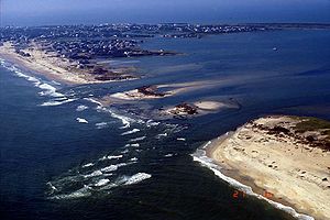
and waves created the inlet by washing out a portion of Hatteras Island between Hatteras and Frisco
Frisco, North Carolina
Frisco is a small unincorporated community on the barrier island of Hatteras Island, between the villages of Buxton and Hatteras. It is located in Dare County, North Carolina, USA, and was previously named Trent, or Trent Woods, but received a new name with the coming of the post office in 1898...
. The break was 2,000 feet (600 m) wide and 15 feet (5 m) deep, and consisted of three distinct channels. The formation of the inlet destroyed a portion of North Carolina Highway 12. For the two months it was in existence, Isabel Inlet separated the town of Hatteras
Hatteras, North Carolina
Hatteras is an unincorporated community in Dare County, North Carolina, United States, on the Outer Banks island of Hatteras. North Carolina Highway 12 passes through the community linking it to Frisco and Ocracoke . It is south of the famous Cape Hatteras and the Cape Hatteras Lighthouse in Buxton...
from the rest of Hatteras Island
Hatteras Island
Hatteras Island is a barrier island located off the North Carolina coast. Dividing the Atlantic Ocean and the Pamlico Sound, it runs parallel to the coast, forming a bend at Cape Hatteras. It is part of North Carolina's Outer Banks and includes the towns of Rodanthe, Waves, Salvo, Avon, Buxton,...
. The lower part became known as Little Hatteras Island.
Initially, long-term solutions to the Isabel Inlet such as building a bridge or a ferry system were considered, though they were ultimately canceled in favor of pumping sand and filling the inlet. Coastal geologists were opposed to the solution, stating the evolution of the Outer Banks is dependent on inlets from hurricanes. Dredging operations began on October 17, about a month after the hurricane struck. The United States Army Corps of Engineers
United States Army Corps of Engineers
The United States Army Corps of Engineers is a federal agency and a major Army command made up of some 38,000 civilian and military personnel, making it the world's largest public engineering, design and construction management agency...
used sand from the ferry channel to the southwest of Hatteras Island, a choice made to minimize impact to submerged aquatic vegetation and due to the channel being filled somewhat during the hurricane. On November 22, about two months after the hurricane struck, Highway 12 and Hatteras Island were reopened to public access. On the same day, the ferry between Hatteras and Ocracoke was reopened. The breach on the southern end of Hatteras Island was filled in with sand, as well.