A
General Circulation Model (GCM) is a
mathematical modelA mathematical model is a description of a system using mathematical concepts and language. The process of developing a mathematical model is termed mathematical modeling. Mathematical models are used not only in the natural sciences and engineering disciplines A mathematical model is a...
of the general circulation of a planetary
atmosphereAn atmosphere is a layer of gases that may surround a material body of sufficient mass, and that is held in place by the gravity of the body. An atmosphere may be retained for a longer duration, if the gravity is high and the atmosphere's temperature is low...
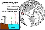
or ocean and based on the Navier–Stokes equations on a rotating sphere with
thermodynamicThermodynamics is a physical science that studies the effects on material bodies, and on radiation in regions of space, of transfer of heat and of work done on or by the bodies or radiation...
terms for various energy sources (
radiationIn physics, radiation is a process in which energetic particles or energetic waves travel through a medium or space. There are two distinct types of radiation; ionizing and non-ionizing...
,
latent heatLatent heat is the heat released or absorbed by a chemical substance or a thermodynamic system during a process that occurs without a change in temperature. A typical example is a change of state of matter, meaning a phase transition such as the melting of ice or the boiling of water. The term was...
). These equations are the basis for complex computer programs commonly used for
simulatingSimulation is the imitation of some real thing available, state of affairs, or process. The act of simulating something generally entails representing certain key characteristics or behaviours of a selected physical or abstract system....
the atmosphere or ocean of the
EarthEarth is the third planet from the Sun, and the densest and fifth-largest of the eight planets in the Solar System. It is also the largest of the Solar System's four terrestrial planets...
. Atmospheric and Oceanic GCMs (AGCM and OGCM) are key components of
Global Climate Models along with
sea iceSea ice is largely formed from seawater that freezes. Because the oceans consist of saltwater, this occurs below the freezing point of pure water, at about -1.8 °C ....
and land-surface components. GCMs and global climate models are widely applied for
weather forecastingWeather forecasting is the application of science and technology to predict the state of the atmosphere for a given location. Human beings have attempted to predict the weather informally for millennia, and formally since the nineteenth century...
, understanding the
climateClimate encompasses the statistics of temperature, humidity, atmospheric pressure, wind, rainfall, atmospheric particle count and other meteorological elemental measurements in a given region over long periods...
, and projecting
climate changeClimate change is a significant and lasting change in the statistical distribution of weather patterns over periods ranging from decades to millions of years. It may be a change in average weather conditions or the distribution of events around that average...
. Versions designed for decade to century time scale climate applications were originally created by
Syukuro Manabeis a Japanese meteorologist and climatologist who pioneered the use of computers to simulate global climate change and natural climate variations.-Scientific accomplishments:...
and
Kirk BryanKirk Bryan is an American oceanographer who is considered to be the founder of numerical ocean modeling. Starting in the 1960s at the Geophysical Fluid Dynamics Laboratory, then located in Washington, D.C., Bryan worked with a series of colleagues to develop numerical schemes for solving the...
at the
Geophysical Fluid Dynamics LaboratoryThe Geophysical Fluid Dynamics Laboratory is a laboratory in the National Oceanic and Atmospheric Administration /Office of Oceanic and Atmospheric Research . The current director is Dr. V...
in
Princeton, New JerseyPrinceton is a community located in Mercer County, New Jersey, United States. It is best known as the location of Princeton University, which has been sited in the community since 1756...
. These computationally intensive numerical models are based on the integration of a variety of fluid dynamical, chemical, and sometimes biological equations.
History
In 1956, Norman Phillips developed a mathematical model which could realistically depict monthly and seasonal patterns in the troposphere, which became the first successful
climate modelClimate models use quantitative methods to simulate the interactions of the atmosphere, oceans, land surface, and ice. They are used for a variety of purposes from study of the dynamics of the climate system to projections of future climate...
. Following Phillips's work, several groups began working to create general circulation models. The first general circulation climate model that combined both oceanic and atmospheric processes was developed in the late 1960s at the NOAA
Geophysical Fluid Dynamics LaboratoryThe Geophysical Fluid Dynamics Laboratory is a laboratory in the National Oceanic and Atmospheric Administration /Office of Oceanic and Atmospheric Research . The current director is Dr. V...
. By the early 1980s, the United States'
National Center for Atmospheric ResearchThe National Center for Atmospheric Research has multiple facilities, including the I. M. Pei-designed Mesa Laboratory headquarters in Boulder, Colorado. NCAR is managed by the nonprofit University Corporation for Atmospheric Research and sponsored by the National Science Foundation...
had developed the Community Atmosphere Model; this model has been continuously refined into the 2000s. In 1996, efforts began to initialize and model soil and vegetation types, which led to more realistic forecasts. Coupled ocean-atmosphere climate models such as the
Hadley Centre for Climate Prediction and ResearchThe Met Office Hadley Centre for Climate Change — named in honour of George Hadley — is part of, and based at the headquarters of the Met Office in Exeter...
's
HadCM3HadCM3 is a coupled atmosphere-ocean general circulation model developed at the Hadley Centre in the United Kingdom...
model are currently being used as inputs for
climate changeClimate change is a significant and lasting change in the statistical distribution of weather patterns over periods ranging from decades to millions of years. It may be a change in average weather conditions or the distribution of events around that average...
studies. The importance of
gravity waveIn fluid dynamics, gravity waves are waves generated in a fluid medium or at the interface between two media which has the restoring force of gravity or buoyancy....
s was neglected within these models until the mid 1980s. Now, gravity waves are required within global climate models in order to properly simulate regional and global scale circulations, though their broad spectrum makes their incorporation complicated.
Atmospheric vs Ocean models
There are both atmospheric GCMs (AGCMs) and oceanic GCMs (OGCMs). An AGCM and an OGCM can be coupled together to form an atmosphere-ocean coupled general circulation model (CGCM or AOGCM). With the addition of other components (such as a sea ice model or a model for evapotranspiration over land), the AOGCM becomes the basis for a full
climate modelClimate models use quantitative methods to simulate the interactions of the atmosphere, oceans, land surface, and ice. They are used for a variety of purposes from study of the dynamics of the climate system to projections of future climate...
. Within this structure, different variations can exist, and their varying response to climate change may be studied (e.g., Sun and Hansen, 2003).
Modeling trends
A recent trend in GCMs is to apply them as components of Earth System Models, e.g. by coupling to
ice sheet modelIce sheet models use quantitative methods to simulate the evolution, dynamics and thermodynamics of ice sheets, such as the Greenland ice sheet, the Antarctic ice sheet or the large ice sheets on the northern hemisphere during the last glacial period...
s for the dynamics of the
GreenlandThe Greenland ice sheet is a vast body of ice covering , roughly 80% of the surface of Greenland. It is the second largest ice body in the world, after the Antarctic Ice Sheet. The ice sheet is almost long in a north-south direction, and its greatest width is at a latitude of 77°N, near its...
and
Antarctic ice sheetThe Antarctic ice sheet is one of the two polar ice caps of the Earth. It covers about 98% of the Antarctic continent and is the largest single mass of ice on Earth. It covers an area of almost 14 million square km and contains 30 million cubic km of ice...
s, and one or more
chemical transport modelA chemical transport model is a type of computer numerical model which typically simulates atmospheric chemistry.- Chemical transport models and general circulation models :...
s (CTMs) for
speciesChemical species are atoms, molecules, molecular fragments, ions, etc., being subjected to a chemical process or to a measurement. Generally, a chemical species can be defined as an ensemble of chemically identical molecular entities that can explore the same set of molecular energy levels on a...
important to climate. Thus a carbon CTM may allow a GCM to better predict changes in
carbon dioxideCarbon dioxide is a naturally occurring chemical compound composed of two oxygen atoms covalently bonded to a single carbon atom...
concentrations resulting from changes in anthropogenic emissions. In addition, this approach allows accounting for inter-system feedback: e.g. chemistry-climate models allow the possible effects of climate change on the recovery of the ozone hole to be studied.
Climate prediction uncertainties depend on uncertainties in chemical, physical, and social models (see IPCC scenarios below). Progress has been made in incorporating more realistic chemistry and physics in the models, but significant uncertainties and unknowns remain, especially regarding the future course of human population, industry, and technology.
Note that many simpler levels of
climate modelClimate models use quantitative methods to simulate the interactions of the atmosphere, oceans, land surface, and ice. They are used for a variety of purposes from study of the dynamics of the climate system to projections of future climate...
exist; some are of only heuristic interest, while others continue to be scientifically relevant.
Model structure
Three-dimensional (more properly four-dimensional) GCMs discretise the equations for fluid motion and integrate these forward in time. They also contain parameterisations for processes – such as convection – that occur on scales too small to be resolved directly. More sophisticated models may include representations of the carbon and other cycles.
A
simple general circulation model (SGCM), a minimal GCM, consists of a dynamical core that relates material properties such as temperature to dynamical properties such as pressure and velocity. Examples are programs that solve the
primitive equationsThe primitive equations are a set of nonlinear differential equations that are used to approximate global atmospheric flow and are used in most atmospheric models...
, given energy input into the model, and energy
dissipationIn physics, dissipation embodies the concept of a dynamical system where important mechanical models, such as waves or oscillations, lose energy over time, typically from friction or turbulence. The lost energy converts into heat, which raises the temperature of the system. Such systems are called...
in the form of scale-dependent
frictionFriction is the force resisting the relative motion of solid surfaces, fluid layers, and/or material elements sliding against each other. There are several types of friction:...
, so that
atmospheric waveAn atmospheric wave is a periodic disturbance in the fields of atmospheric variables which may either propagate or not . Atmospheric waves range in spatial and temporal scale from large-scale planetary waves to minute sound waves...
s with the highest
wavenumberIn the physical sciences, the wavenumber is a property of a wave, its spatial frequency, that is proportional to the reciprocal of the wavelength. It is also the magnitude of the wave vector...
s are the ones most strongly attenuated. Such models may be used to study atmospheric processes within a simplified framework but are not suitable for future climate projections.
Atmospheric GCMs (AGCMs) model the atmosphere (and typically contain a land-surface model as well) and impose
sea surface temperatureSea surface temperature is the water temperature close to the oceans surface. The exact meaning of surface varies according to the measurement method used, but it is between and below the sea surface. Air masses in the Earth's atmosphere are highly modified by sea surface temperatures within a...
s (SSTs). A large amount of information including model documentation is available from
AMIPAtmospheric Model Intercomparison Project is a standard experimental protocol for global atmospheric general circulation models . It provides a community-based infrastructure in support of climate model diagnosis, validation, intercomparison, documentation and data access...
. They may include atmospheric chemistry.
- AGCMs consist of a dynamical core which integrates the equations of fluid motion, typically for:
- surface pressure
- horizontal components of velocity in layers
- temperature and water vapor in layers
- There is generally a radiation code, split into solar/short wave and terrestrial/infra-red/long wave
- Parametrizations
Parameterization in a weather or climate model within numerical weather prediction refers to the method of replacing processes that are too small-scale or complex to be physically represented in the model by a simplified process. This can be contrasted with other processes—e.g., large-scale flow of...
are used to include the effects of various processes. All modern AGCMs include parameterizations for:
- convection
- land surface processes, albedo
Albedo , or reflection coefficient, is the diffuse reflectivity or reflecting power of a surface. It is defined as the ratio of reflected radiation from the surface to incident radiation upon it...
and hydrologyHydrology is the study of the movement, distribution, and quality of water on Earth and other planets, including the hydrologic cycle, water resources and environmental watershed sustainability...
- cloud cover
A GCM contains a number of
prognostic equationPrognostic equation - in the context of physical simulation, a prognostic equation predicts the value of variables for some time in the future on the basis of the values at the current or previous times....
s that are stepped forward in time (typically winds, temperature, moisture, and surface pressure) together with a number of
diagnostic equationIn a physical simulation context, a diagnostic equation is an equation that links the values of these variables simultaneously, either because the equation is time-independent, or because the variables all refer to the values they have at the same identical time...
s that are evaluated from the simultaneous values of the variables. As an example, pressure at any height can be diagnosed by applying the hydrostatic equation to the predicted surface pressure and the predicted values of temperature between the surface and the height of interest. The pressure diagnosed in this way then is used to compute the pressure gradient force in the time-dependent equation for the winds.
Oceanic GCMs (OGCMs) model the ocean (with fluxes from the atmosphere imposed) and may or may not contain a
sea iceSea ice is largely formed from seawater that freezes. Because the oceans consist of saltwater, this occurs below the freezing point of pure water, at about -1.8 °C ....
model. For example, the standard resolution of HadOM3 is 1.25 degrees in latitude and longitude, with 20 vertical levels, leading to approximately 1,500,000 variables.
Coupled atmosphere-ocean GCMs (AOGCMs) (e.g.
HadCM3HadCM3 is a coupled atmosphere-ocean general circulation model developed at the Hadley Centre in the United Kingdom...
,
GFDL CM2.XGFDL CM2.X is a coupled atmosphere-ocean general circulation model developed at the NOAA Geophysical Fluid Dynamics Laboratory in the United States...
) combine the two models. They thus have the advantage of removing the need to specify fluxes across the interface of the ocean surface. These models are the basis for sophisticated model predictions of future climate, such as are discussed by the
IPCCThe Intergovernmental Panel on Climate Change is a scientific intergovernmental body which provides comprehensive assessments of current scientific, technical and socio-economic information worldwide about the risk of climate change caused by human activity, its potential environmental and...
.
AOGCMs represent the pinnacle of complexity in climate models and internalise as many processes as possible. They are the only tools that could provide detailed regional predictions of future climate change. However, they are still under development. The simpler models are generally susceptible to simple analysis and their results are generally easy to understand. AOGCMs, by contrast, are often nearly as hard to analyse as the real climate system.
Model grids
The fluid equations for AGCMs are discretised using either the
finite difference methodIn mathematics, finite-difference methods are numerical methods for approximating the solutions to differential equations using finite difference equations to approximate derivatives.- Derivation from Taylor's polynomial :...
or the
spectral methodSpectral methods are a class of techniques used in applied mathematics and scientific computing to numerically solve certain Dynamical Systems, often involving the use of the Fast Fourier Transform. Where applicable, spectral methods have excellent error properties, with the so called "exponential...
. For finite differences, a grid is imposed on the atmosphere. The simplest grid uses constant angular grid spacing (i.e., a latitude / longitude grid), however, more sophisticated non-rectantangular grids (e.g., icohedral) and grids of variable resolution are more often used. The "LMDz" model can be arranged to give high resolution over any given section of the planet.
HadGEM1HadGEM1 is a coupled climate model developed at the Met Office’s Hadley Centre. It represents a significant advance on its predecessor, HadCM3, in terms of its science and is better at carrying out new climate experiments...
(and other ocean models) use an ocean grid with higher resolution in the tropics to help resolve processes believed to be important for
ENSOEnsō is a Japanese word meaning "circle" and a concept strongly associated with Zen. Ensō is one of the most common subjects of Japanese calligraphy even though it is a symbol and not a character. It symbolizes the Absolute enlightenment, strength, elegance, the Universe, and the void; it can...
. Spectral models generally use a
gaussian gridA Gaussian grid is used in the earth sciences as a gridded horizontal coordinate system for scientific modeling on a sphere...
, because of the mathematics of transformation between spectral and grid-point space. Typical AGCM resolutions are between 1 and 5 degrees in latitude or longitude: the Hadley Centre model HadCM3, for example, uses 3.75 in longitude and 2.5 degrees in latitude, giving a grid of 96 by 73 points (96 x 72 for some variables); and has 19 levels in the vertical. This results in approximately 500,000 "basic" variables, since each grid point has four variables (
u,vWind speed, or wind velocity, is a fundamental atmospheric rate.Wind speed affects weather forecasting, aircraft and maritime operations, construction projects, growth and metabolism rate of many plant species, and countless other implications....
,
TTemperature is a physical property of matter that quantitatively expresses the common notions of hot and cold. Objects of low temperature are cold, while various degrees of higher temperatures are referred to as warm or hot...
,
QHumidity is a term for the amount of water vapor in the air, and can refer to any one of several measurements of humidity. Formally, humid air is not "moist air" but a mixture of water vapor and other constituents of air, and humidity is defined in terms of the water content of this mixture,...
), though a full count would give more (clouds; soil levels). HadGEM1 uses a grid of 1.875 degrees in longitude and 1.25 in latitude in the atmosphere; HiGEM, a high-resolution variant, uses 1.25 x 0.83 degrees respectively. These resolutions are lower than is typically used for weather forecasting. Ocean resolutions tend to be higher, for example HadCM3 has 6 ocean grid points per atmospheric grid point in the horizontal.
For a standard finite difference model, uniform gridlines converge towards the poles. This would lead to computational instabilities (see
CFL conditionIn mathematics, the Courant–Friedrichs–Lewy condition is a necessary condition for convergence while solving certain partial differential equations numerically by the method of finite differences. It arises when explicit time-marching schemes are used for the numerical solution...
) and so the model variables must be filtered along lines of latitude close to the poles. Ocean models suffer from this problem too, unless a rotated grid is used in which the North Pole is shifted onto a nearby landmass. Spectral models do not suffer from this problem. There are experiments using
geodesic gridA geodesic grid is a technique used to model the surface of a sphere with a subdivided polyhedron, usually an icosahedron.-Introduction:...
s and icosahedral grids, which (being more uniform) do not have pole-problems. Another approach to solving the grid spacing problem is to deform a Cartesian cube such that it covers the surface of a sphere.
Flux correction
Some early incarnations of AOGCMs required a somewhat
ad hoc process of "flux correction" to achieve a stable climate (not all model groups used this technique). This resulted from separately prepared ocean and atmospheric models each having a different implicit flux from the other component than the other component could actually provide. If uncorrected this could lead to a dramatic drift away from observations in the coupled model. However, if the fluxes were 'corrected', the problems in the model that led to these unrealistic fluxes might be unrecognised and that might affect the model sensitivity. As a result, there has always been a strong disincentive to use flux corrections, and the vast majority of models used in the current round of the
Intergovernmental Panel on Climate ChangeThe Intergovernmental Panel on Climate Change is a scientific intergovernmental body which provides comprehensive assessments of current scientific, technical and socio-economic information worldwide about the risk of climate change caused by human activity, its potential environmental and...
do not use them. The model improvements that now make flux corrections unnecessary are various, but include improved ocean physics, improved resolution in both atmosphere and ocean, and more physically consistent coupling between atmosphere and ocean models.
Convection
Moist convection causes the release of latent heat and is important to the Earth's energy budget. Convection occurs on too small a scale to be resolved by climate models, and hence must be parameterised. This has been done since the earliest days of climate modelling, in the 1950s. Akio Arakawa did much of the early work and variants of his scheme are still used
http://www.aip.org/history/climate/arakawa.htm although there is a variety of different schemes now in use
http://grads.iges.org/reps/rep27/colarep27.html http://www-pcmdi.llnl.gov/projects/modeldoc/amip/10Tbl2.10.html http://rainbow.llnl.gov/projects/modeldoc/cmip/table4.html. The behavior of clouds is still poorly understood and is parametrized.
http://www.aip.org/history/climate/GCM.htm.
Output variables
Most models include software to diagnose a wide range of variables for comparison with observations or study of atmospheric processes. An example is the 1.5 metre temperature, which is the standard height for near-surface observations of air temperature. This temperature is not directly predicted from the model but is deduced from the surface and lowest-model-layer temperatures. Other software is used for creating plots and animations.
Projections of future climate change
Coupled ocean-atmosphere GCMs use
transient climate simulationA transient climate simulation is a mode of running a global climate model in which a period of time is simulated with continuously-varying concentrations of greenhouse gases so that the climate of the model represents a realistic mode of possible change in the real world.- Related models :This...
s to project/predict future temperature changes under various scenarios. These can be idealised scenarios (most commonly, CO
2 increasing at 1%/yr) or more realistic (usually the "IS92a" or more recently the
SRESThe Special Report on Emissions Scenarios was prepared by the Intergovernmental Panel on Climate Change in 2000, based on data developed at the Earth Institute at Columbia University. The emissions scenarios described in the Report have been used to make projections of possible future climate...
scenarios). Which scenarios should be considered most realistic is currently uncertain, as the projections of future CO
2 (and sulphate) emission are themselves uncertain.
The 2001
IPCC Third Assessment ReportThe IPCC Third Assessment Report, Climate Change 2001, is an assessment of available scientific and socio-economic information on climate change by the IPCC. The IPCC was established in 1988 by the United Nations Environment Programme and the UN's World Meteorological Organization ".....
figure 9.3 shows the global mean response of 19 different coupled models to an idealised experiment in which CO
2 is increased at 1% per year
http://www.grida.no/climate/ipcc_tar/wg1/348.htm#fig93.
Figure 9.5 shows the response of a smaller number of models to more realistic forcing. For the 7 climate models shown there, the temperature change to 2100 varies from 2 to 4.5 °C with a median of about 3 °C.
Future scenarios do not include unknowable events – for example, volcanic eruptions or changes in solar forcing. These effects are believed to be small in comparison to GHG forcing in the long term, but large volcanic eruptions, for example, are known to exert a temporary cooling effect.
Human emissions of GHGs are an external input to the models, although it would be possible to couple in an economic model to provide these as well. Atmospheric GHG levels are usually supplied as an input, though it is possible to include a carbon cycle model including land vegetation and oceanic processes to calculate GHG levels.
Emissions scenarios
For the six SRES marker scenarios, IPCC (2007:7–8) gave a "best estimate" of global mean temperature increase (2090–2099 relative to the period 1980–1999) that ranged from 1.8 °C to 4.0 °C. Over the same time period, the "likely" range (greater than 66% probability, based on expert judgement) for these scenarios was for a global mean temperature increase of between 1.1 and 6.4 °C.
Pope (2008) described a study where climate change projections were made using several different emission scenarios. In a scenario where global emissions start to decrease by 2010 and then decline at a sustained rate of 3% per year, the likely global average temperature increase was predicted to be 1.7 °C above pre-industrial levels by 2050, rising to around 2 °C by 2100. In a projection designed to simulate a future where no efforts are made to reduce global emissions, the likely rise in global average temperature was predicted to be 5.5 °C by 2100. A rise as high as 7 °C was thought possible but less likely.
Sokolov
et al. (2009) examined a scenario designed to simulate a future where there is no policy to reduce emissions. In their integrated model, this scenario resulted in a median warming over land (2090–2099 relative to the period 1980–1999) of 5.1 °C. Under the same emissions scenario but with different modeling of the future climate, the predicted median warming was 4.1 °C.
Accuracy of models that predict global warming
AOGCMs represent the pinnacle of complexity in climate models and internalise as many processes as possible. However, they are still under development and uncertainties remain. They may be coupled to models of other processes, such as the
carbon cycleThe carbon cycle is the biogeochemical cycle by which carbon is exchanged among the biosphere, pedosphere, geosphere, hydrosphere, and atmosphere of the Earth...
, so as to better model feedback effects. Most recent simulations show "plausible" agreement with the measured temperature anomalies over the past 150 years, when forced by observed changes in greenhouse gases and aerosols, but better agreement is achieved when natural forcings are also included.
No model – whether a wind tunnel model for designing aircraft, or a climate model for projecting global warming – perfectly reproduces the system being modeled. Such inherently imperfect models may nevertheless produce useful results. In this context, GCMs are capable of reproducing the general features of the observed global temperature over the past century.
A debate over how to reconcile climate model predictions that upper air (tropospheric) warming should be greater than surface warming, with observations some of which appeared to show otherwise now appears to have been resolved in favour of the models, following revisions to the data: see satellite temperature record.
The effects of clouds are a significant area of uncertainty in climate models. Clouds have
competing effects on the climate. One of the roles that clouds play in climate is in cooling the surface by reflecting sunlight back into space; another is warming by increasing the amount of infrared radiation emitted from the atmosphere to the surface. In the 2001 IPCC report on climate change, the possible changes in cloud cover were highlighted as one of the dominant uncertainties in predicting future climate change; see also
Thousands of climate researchers around the world use climate models to understand the climate system. There are thousands of papers published about model-based studies in peer-reviewed journals – and a part of this research is work improving the models. Improvement has been difficult but steady (most obviously, state of the art AOGCMs no longer require flux correction), and progress has sometimes led to discovering new uncertainties.
In 2000, a comparison between measurements and dozens of GCM simulations of
ENSOEnsō is a Japanese word meaning "circle" and a concept strongly associated with Zen. Ensō is one of the most common subjects of Japanese calligraphy even though it is a symbol and not a character. It symbolizes the Absolute enlightenment, strength, elegance, the Universe, and the void; it can...
-driven tropical precipitation, water vapor, temperature, and outgoing longwave radiation found similarity between measurements and simulation of most factors. However the simulated change in precipitation was about one-fourth less than what was observed. Errors in simulated precipitation imply errors in other processes, such as errors in the evaporation rate that provides moisture to create precipitation. The other possibility is that the satellite-based measurements are in error. Either indicates progress is required in order to monitor and predict such changes.
http://ams.allenpress.com/amsonline/?request=get-abstract&doi=10.1175%2F1520-0442(2000)013%3C0538:TSOTTH%3E2.0.CO%3B2
A more complete discussion of climate models is provided in the IPCC's Third Assessment Report.
- The model mean exhibits good agreement with observations.
- The individual models often exhibit worse agreement with observations.
- Many of the non-flux adjusted models suffered from unrealistic climate drift up to about 1 °C/century in global mean surface temperature.
- The errors in model-mean surface air temperature rarely exceed 1 °C over the oceans and 5 °C over the continents; precipitation and sea level pressure errors are relatively greater but the magnitudes and patterns of these quantities are recognisably similar to observations.
- Surface air temperature is particularly well simulated, with nearly all models closely matching the observed magnitude of variance and exhibiting a correlation > 0.95 with the observations.
- Simulated variance of sea level pressure and precipitation is within ±25% of observed.
- All models have shortcomings in their simulations of the present day climate of the stratosphere, which might limit the accuracy of predictions of future climate change.
- There is a tendency for the models to show a global mean cold bias at all levels.
- There is a large scatter in the tropical temperatures.
- The polar night jets in most models are inclined poleward with height, in noticeable contrast to an equatorward inclination of the observed jet.
- There is a differing degree of separation in the models between the winter sub-tropical jet and the polar night jet.
- For nearly all models the r.m.s. error in zonal- and annual-mean surface air temperature is small compared with its natural variability.
- There are problems in simulating natural seasonal variability. ( 2000)
- In flux-adjusted models, seasonal variations are simulated to within 2 K
The kelvin is a unit of measurement for temperature. It is one of the seven base units in the International System of Units and is assigned the unit symbol K. The Kelvin scale is an absolute, thermodynamic temperature scale using as its null point absolute zero, the temperature at which all...
of observed values over the oceans. The corresponding average over non-flux-adjusted models shows errors up to about 6 K in extensive ocean areas.
- Near-surface land temperature errors are substantial in the average over flux-adjusted models, which systematically underestimates (by about 5 K) temperature in areas of elevated terrain. The corresponding average over non-flux-adjusted models forms a similar error pattern (with somewhat increased amplitude) over land.
- In Southern Ocean mid-latitudes, the non-flux-adjusted models overestimate the magnitude of January-minus-July temperature differences by ~5 K due to an overestimate of summer (January) near-surface temperature. This error is common to five of the eight non-flux-adjusted models.
- Over Northern Hemisphere mid-latitude land areas, zonal mean differences between July and January temperatures simulated by the non-flux-adjusted models show a greater spread (positive and negative) about observed values than results from the flux-adjusted models.
- The ability of coupled GCMs to simulate a reasonable seasonal cycle is a necessary condition for confidence in their prediction of long-term climatic changes (such as global warming), but it is not a sufficient condition unless the seasonal cycle and long-term changes involve similar climatic processes.
- Coupled climate models do not simulate with reasonable accuracy clouds and some related hydrological processes (in particular those involving upper tropospheric humidity). Problems in the simulation of clouds and upper tropospheric humidity, remain worrisome because the associated processes account for most of the uncertainty in climate model simulations of anthropogenic change.
The precise magnitude of future changes in climate is still uncertain; for the end of the 21st century (2071 to 2100), for
SRESThe Special Report on Emissions Scenarios was prepared by the Intergovernmental Panel on Climate Change in 2000, based on data developed at the Earth Institute at Columbia University. The emissions scenarios described in the Report have been used to make projections of possible future climate...
scenario A2, the change of global average SAT change from AOGCMs compared with 1961 to 1990 is +3.0 °C (4.8 °F) and the range is +1.3 to +4.5 °C (+2 to +7.2 °F).
Relation to weather forecasting
The global climate models used for climate projections are very similar in structure to (and often share computer code with)
numerical models for weather predictionNumerical weather prediction uses mathematical models of the atmosphere and oceans to predict the weather based on current weather conditions. Though first attempted in the 1920s, it was not until the advent of computer simulation in the 1950s that numerical weather predictions produced realistic...
but are nonetheless logically distinct.
Most
weather forecastingWeather forecasting is the application of science and technology to predict the state of the atmosphere for a given location. Human beings have attempted to predict the weather informally for millennia, and formally since the nineteenth century...
is done on the basis of interpreting the output of numerical model results. Since forecasts are short—typically a few days or a week—such models do not usually contain an ocean model but rely on imposed SSTs. They also require accurate initial conditions to begin the forecast—typically these are taken from the output of a previous forecast, with observations blended in. Because the results are needed quickly the predictions must be run in a few hours; but because they only need to cover a week of real time these predictions can be run at higher resolution than in climate mode. Currently the ECMWF runs at 40 km (24.9 mi) resolution
http://www.ecmwf.int/index_forecasts.html as opposed to the 100 kilometre scale used by typical climate models. Often nested models are run forced by the global models for boundary conditions, to achieve higher local resolution: for example, the
Met OfficeThe Met Office , is the United Kingdom's national weather service, and a trading fund of the Department for Business, Innovation and Skills...
runs a mesoscale model with an 11 km (6.8 mi) resolution
http://www.metoffice.gov.uk/research/nwp/numerical/operational/index.html covering the UK, and various agencies in the U.S. also run nested models such as the NGM and NAM models. Like most global numerical weather prediction models such as the
GFSThe Global Forecast System is a global numerical weather prediction computer model run by NOAA. This mathematical model is run four times a day and produces forecasts up to 16 days in advance, but with decreasing spatial and temporal resolution over time...
, global climate models are often spectral models
http://www-das.uwyo.edu/~geerts/cwx/notes/chap12/nwp_gcm.html instead of grid models. Spectral models are often used for global models because some computations in modeling can be performed faster thus reducing the time needed to run the model simulation.
Computations involved
Climate models use quantitative methods to simulate the interactions of the
atmosphereThe atmosphere of Earth is a layer of gases surrounding the planet Earth that is retained by Earth's gravity. The atmosphere protects life on Earth by absorbing ultraviolet solar radiation, warming the surface through heat retention , and reducing temperature extremes between day and night...
, oceans, land surface, and
iceThe cryosphere is the term which collectively describes the portions of the Earth’s surface where water is in solid form, including sea ice, lake ice, river ice, snow cover, glaciers, ice caps and ice sheets, and frozen ground . Thus there is a wide overlap with the hydrosphere...
. They are used for a variety of purposes from study of the dynamics of the climate system to projections of future
climateClimate encompasses the statistics of temperature, humidity, atmospheric pressure, wind, rainfall, atmospheric particle count and other meteorological elemental measurements in a given region over long periods...
.
All climate models take account of incoming energy as short wave
electromagnetic radiationElectromagnetic radiation is a form of energy that exhibits wave-like behavior as it travels through space...
, chiefly
visibleThe visible spectrum is the portion of the electromagnetic spectrum that is visible to the human eye. Electromagnetic radiation in this range of wavelengths is called visible light or simply light. A typical human eye will respond to wavelengths from about 390 to 750 nm. In terms of...
and short-wave (near)
infraredInfrared light is electromagnetic radiation with a wavelength longer than that of visible light, measured from the nominal edge of visible red light at 0.74 micrometres , and extending conventionally to 300 µm...
, as well as outgoing energy as long wave (far)
infraredInfrared light is electromagnetic radiation with a wavelength longer than that of visible light, measured from the nominal edge of visible red light at 0.74 micrometres , and extending conventionally to 300 µm...
electromagnetic radiation from the earth. Any imbalance results in a
change in temperatureThe first law of thermodynamics is an expression of the principle of conservation of work.The law states that energy can be transformed, i.e. changed from one form to another, but cannot be created nor destroyed...
.
The most talked-about models of recent years have been those relating temperature to
emissionExhaust gas or flue gas is emitted as a result of the combustion of fuels such as natural gas, gasoline/petrol, diesel fuel, fuel oil or coal. According to the type of engine, it is discharged into the atmosphere through an exhaust pipe, flue gas stack or propelling nozzle.It often disperses...
s of
carbon dioxideCarbon dioxide is a naturally occurring chemical compound composed of two oxygen atoms covalently bonded to a single carbon atom...
(see
greenhouse gasA greenhouse gas is a gas in an atmosphere that absorbs and emits radiation within the thermal infrared range. This process is the fundamental cause of the greenhouse effect. The primary greenhouse gases in the Earth's atmosphere are water vapor, carbon dioxide, methane, nitrous oxide, and ozone...
). These models project an upward trend in the surface temperature record, as well as a more rapid increase in temperature at higher altitudes.
Three (or more properly, four since time is also considered) dimensional GCM's discretise the equations for fluid motion and energy transfer and integrate these over time. They also contain parametrisations for processes—such as convection—that occur on scales too small to be resolved directly.
Atmospheric GCMs (AGCMs) model the atmosphere and impose
sea surface temperatureSea surface temperature is the water temperature close to the oceans surface. The exact meaning of surface varies according to the measurement method used, but it is between and below the sea surface. Air masses in the Earth's atmosphere are highly modified by sea surface temperatures within a...
s as boundary conditions. Coupled atmosphere-ocean GCMs (AOGCMs, e.g.
HadCM3HadCM3 is a coupled atmosphere-ocean general circulation model developed at the Hadley Centre in the United Kingdom...
,
EdGCMThe Educational Global Climate Model or ' is a fully functional global climate model that has been ported for use on desktop computers...
,
GFDL CM2.XGFDL CM2.X is a coupled atmosphere-ocean general circulation model developed at the NOAA Geophysical Fluid Dynamics Laboratory in the United States...
, ARPEGE-Climat) combine the two models.
Models can range from relatively simple to quite complex:
- A simple radiant heat transfer model that treats the earth as a single point and averages outgoing energy
- this can be expanded vertically (radiative-convective models), or horizontally
- finally, (coupled) atmosphere–ocean–sea ice
Sea ice is largely formed from seawater that freezes. Because the oceans consist of saltwater, this occurs below the freezing point of pure water, at about -1.8 °C ....
global climate models discretise and solve the full equations for mass and energy transfer and radiant exchange.
This is not a full list; for example "box models" can be written to treat flows across and within ocean basins. Furthermore, other types of modelling can be interlinked, such as
land useLand use is the human use of land. Land use involves the management and modification of natural environment or wilderness into built environment such as fields, pastures, and settlements. It has also been defined as "the arrangements, activities and inputs people undertake in a certain land cover...
, allowing researchers to predict the interaction between climate and ecosystems.
Box models
Box models are simplified versions of complex systems, reducing them to boxes (or reservoirs) linked by fluxes. The boxes are assumed to be mixed homogeneously. Within a given box, the concentration of any
chemical speciesChemical species are atoms, molecules, molecular fragments, ions, etc., being subjected to a chemical process or to a measurement. Generally, a chemical species can be defined as an ensemble of chemically identical molecular entities that can explore the same set of molecular energy levels on a...
is therefore uniform. However, the abundance of a species within a given box may vary as a function of time due to the input to (or loss from) the box or due to the production, consumption or decay of this species within the box.
Simple box models, i.e. box model with a small number of boxes whose properties (e.g. their volume) do not change with time, are often useful to derive analytical formulas describing the dynamics and steady-state abundance of a species. More complex box models are usually solved using numerical techniques.
Box models are used extensively to model environmental systems or ecosystems and in studies of ocean circulation and the
carbon cycleThe carbon cycle is the biogeochemical cycle by which carbon is exchanged among the biosphere, pedosphere, geosphere, hydrosphere, and atmosphere of the Earth...
.
Zero-dimensional models
A very simple model of the radiative equilibrium of the Earth is:
where
- the left hand side represents the incoming energy from the Sun
- the right hand side represents the outgoing energy from the Earth, calculated from the Stefan-Boltzmann law assuming a constant radiative temperature, T, that is to be found,
and
- S is the solar constant
The solar constant, a measure of flux density, is the amount of incoming solar electromagnetic radiation per unit area that would be incident on a plane perpendicular to the rays, at a distance of one astronomical unit...
– the incoming solar radiation per unit area—about 1367 W·m−2
-
is the EarthEarth is the third planet from the Sun, and the densest and fifth-largest of the eight planets in the Solar System. It is also the largest of the Solar System's four terrestrial planets...
's average albedoAlbedo , or reflection coefficient, is the diffuse reflectivity or reflecting power of a surface. It is defined as the ratio of reflected radiation from the surface to incident radiation upon it...
, measured to be 0.3.
- r is Earth's radius—approximately 6.371×10⁶m
- π
' is a mathematical constant that is the ratio of any circle's circumference to its diameter. is approximately equal to 3.14. Many formulae in mathematics, science, and engineering involve , which makes it one of the most important mathematical constants...
is the mathematical constant (3.141...)
-
is the Stefan-Boltzmann constantThe Stefan–Boltzmann constant , a physical constant denoted by the Greek letter σ, is the constant of proportionality in the Stefan–Boltzmann law: the total energy radiated per unit surface area of a black body in unit time is proportional to the fourth power of the thermodynamic temperature.The...
—approximately 5.67×10⁻⁸ J·K−4·m−2·s−1
-
is the effective emissivityThe emissivity of a material is the relative ability of its surface to emit energy by radiation. It is the ratio of energy radiated by a particular material to energy radiated by a black body at the same temperature...
of earth, about 0.612
The constant
πr2 can be factored out, giving
Solving for the temperature,
This yields an average earth temperature of 288 K. This is because the above equation represents the effective
radiative temperature of the Earth (including the clouds and atmosphere). The use of effective emissivity and albedo account for the
greenhouse effectThe greenhouse effect is a process by which thermal radiation from a planetary surface is absorbed by atmospheric greenhouse gases, and is re-radiated in all directions. Since part of this re-radiation is back towards the surface, energy is transferred to the surface and the lower atmosphere...
.
This very simple model is quite instructive. For example, it easily determines the effect on average earth temperature of changes in solar constant or change of albedo or effective earth emissivity. Using the simple formula, the percent change of the average amount of each parameter, considered independently, to cause a one degree Celsius change in steady-state average earth temperature is as follows:
- Solar constant 1.4%
- Albedo 3.3%
- Effective emissivity 1.4%
The average emissivity of the earth is readily estimated from available data. The emissivities of terrestrial surfaces are all in the range of 0.96 to 0.99 (except for some small desert areas which may be as low as 0.7). Clouds, however, which cover about half of the earth’s surface, have an average emissivity of about 0.5 (which must be reduced by the fourth power of the ratio of cloud absolute temperature to average earth absolute temperature) and an average cloud temperature of about 258 K. Taking all this properly into account results in an effective earth emissivity of about 0.64 (earth average temperature 285 K).
This simple model readily determines the effect of changes in solar output or change of earth albedo or effective earth emissivity on average earth temperature. It says nothing, however about what might cause these things to change. Zero-dimensional models do not address the temperature distribution on the earth or the factors that move energy about the earth.
Radiative-Convective Models
The zero-dimensional model above, using the solar constant and given average earth temperature, determines the effective earth emissivity of long wave radiation emitted to space. This can be refined in the vertical to a zero-dimensional radiative-convective model, which considers two processes of energy transport:
- upwelling and downwelling radiative transfer through atmospheric layers that both absorb and emit infrared radiation
- upward transport of heat by convection (especially important in the lower troposphere
The troposphere is the lowest portion of Earth's atmosphere. It contains approximately 80% of the atmosphere's mass and 99% of its water vapor and aerosols....
).
The radiative-convective models have advantages over the simple model: they can determine the effects of varying
greenhouse gasA greenhouse gas is a gas in an atmosphere that absorbs and emits radiation within the thermal infrared range. This process is the fundamental cause of the greenhouse effect. The primary greenhouse gases in the Earth's atmosphere are water vapor, carbon dioxide, methane, nitrous oxide, and ozone...
concentrations on effective emissivity and therefore the surface temperature. But added parameters are needed to determine local emissivity and albedo and address the factors that move energy about the earth.
Links:
- "Effect of Ice-Albedo Feedback on Global Sensitivity in a One-Dimensional Radiative-Convective Climate Model"
- http://www.grida.no/climate/ipcc_tar/wg1/258.htm
Higher Dimension Models
The zero-dimensional model may be expanded to consider the energy transported horizontally in the atmosphere. This kind of model may well be
zonallyThe terms zonal and meridional are used to describe directions on a globe. Zonal means "along a latitude circle" or "in the west–east direction"; while meridional means "along a meridian" or "in the north–south direction"....
averaged. This model has the advantage of allowing a rational dependence of local albedo and emissivity on temperature – the poles can be allowed to be icy and the equator warm – but the lack of true dynamics means that horizontal transports have to be specified.
- http://www.shodor.org/master/environmental/general/energy/application.html
EMICs (Earth-system Models of Intermediate Complexity)
Depending on the nature of questions asked and the pertinent time scales, there are, on the one extreme, conceptual, more inductive models, and, on the other extreme, general circulation models operating at the highest spatial and temporal resolution currently feasible. Models of intermediate complexity bridge the gap. One example is the Climber-3 model. Its atmosphere is a 2.5-dimensional statistical-dynamical model with 7.5° × 22.5° resolution and time step of 1/2 a day; the ocean is MOM-3 (
Modular Ocean ModelThe modular ocean model is a three-dimensional ocean circulation model designed primarily for studying the ocean climate system. The model is developed and supported primarily by researchers at the National Oceanic and Atmospheric Administration's Geophysical Fluid Dynamics Laboratory .- Overview...
) with a 3.75° × 3.75° grid and 24 vertical levels.
- http://www.pik-potsdam.de/emics/
Climate modellers
A climate modeller is a person who designs, develops, implements, tests, maintains or exploits climate models. There are three major types of institutions where a climate modeller may be found:
- In a national meteorological service. Most national weather services have at least a climatology
Climatology is the study of climate, scientifically defined as weather conditions averaged over a period of time, and is a branch of the atmospheric sciences...
section.
- In a university. Departments that may have climate modellers on staff include atmospheric sciences, meteorology, climatology, or geography, amongst others.
- In national or international research laboratories specialising in this field, such as the National Center for Atmospheric Research
The National Center for Atmospheric Research has multiple facilities, including the I. M. Pei-designed Mesa Laboratory headquarters in Boulder, Colorado. NCAR is managed by the nonprofit University Corporation for Atmospheric Research and sponsored by the National Science Foundation...
(NCAR, in Boulder, ColoradoBoulder is the county seat and most populous city of Boulder County and the 11th most populous city in the U.S. state of Colorado. Boulder is located at the base of the foothills of the Rocky Mountains at an elevation of...
, USA), the Geophysical Fluid Dynamics LaboratoryThe Geophysical Fluid Dynamics Laboratory is a laboratory in the National Oceanic and Atmospheric Administration /Office of Oceanic and Atmospheric Research . The current director is Dr. V...
(GFDL, in Princeton, New JerseyPrinceton is a community located in Mercer County, New Jersey, United States. It is best known as the location of Princeton University, which has been sited in the community since 1756...
, USA), the Hadley Centre for Climate Prediction and ResearchThe Met Office Hadley Centre for Climate Change — named in honour of George Hadley — is part of, and based at the headquarters of the Met Office in Exeter...
(in ExeterExeter is a historic city in Devon, England. It lies within the ceremonial county of Devon, of which it is the county town as well as the home of Devon County Council. Currently the administrative area has the status of a non-metropolitan district, and is therefore under the administration of the...
, UK), the Max Planck Institute for Meteorology in Hamburg, Germany, or the Institut Pierre-Simon Laplace (IPSL in Paris, France). The World Climate Research ProgrammeThe World Climate Research Programme was established in 1980, under the joint sponsorship of International Council for Science and the World Meteorological Organization, and has also been sponsored by the Intergovernmental Oceanographic Commission of UNESCO since 1993. It is a component of the...
(WCRP), hosted by the World Meteorological OrganizationThe World Meteorological Organization is an intergovernmental organization with a membership of 189 Member States and Territories. It originated from the International Meteorological Organization , which was founded in 1873...
(WMO), coordinates research activities on climate modelling worldwide.
See also
- Atmospheric Model Intercomparison Project
Atmospheric Model Intercomparison Project is a standard experimental protocol for global atmospheric general circulation models . It provides a community-based infrastructure in support of climate model diagnosis, validation, intercomparison, documentation and data access...
(AMIP)
- Atmospheric Radiation Measurement
The United States Department of Energy's Atmospheric Radiation Measurement Program was created in 1989 to develop several highly instrumented ground stations to study cloud formation processes and their influence on radiative transfer...
(ARM) (in the US)
- CCCma
CCCma is a division of the Climate Research Branch of the Meteorological Service of Canada of Environment Canada based out of the University of Victoria, Victoria, British Columbia. Its purpose is to contribute to research in climate modelling and climate change...
- Climateprediction.net
Climateprediction.net, or CPDN, is a distributed computing project to investigate and reduce uncertainties in climate modelling. It aims to do this by running hundreds of thousands of different models using the donated idle time of ordinary personal computers, thereby leading to a better...
is a distributed computing project.
- Earth Simulator
The Earth Simulator , developed by the Japanese government's initiative "Earth Simulator Project", was a highly parallel vector supercomputer system for running global climate models to evaluate the effects of global warming and problems in solid earth geophysics...
- EdGCM
The Educational Global Climate Model or ' is a fully functional global climate model that has been ported for use on desktop computers...
- GFDL CM2.X
GFDL CM2.X is a coupled atmosphere-ocean general circulation model developed at the NOAA Geophysical Fluid Dynamics Laboratory in the United States...
- Global Environmental Multiscale Model
The Global Environmental Multiscale Model is an integrated forecasting and data assimilation system developed in the Recherche en Prévision Numérique , Meteorological Research Branch , and the Canadian Meteorological Centre ....
- HadCM3
HadCM3 is a coupled atmosphere-ocean general circulation model developed at the Hadley Centre in the United Kingdom...
- Intermediate General Circulation Model
The Reading Intermediate General Circulation Model , is a simplified or "intermediate" Global climate model, which is developed by members of the at the University of Reading, and by members of the of the Department of Atmospheric and Oceanic Sciences at McGill UniversityThe IGCM is a fast GCM...
- NCAR
- Prognostic variable
A prognostic variable is a variable that a global climate model predicts by integration of a physical equation, typically vorticity, divergence, temperature, surface pressure, and water vapour concentration....
Climate models on the web
- National Operational Model Archive and Distribution System (NOMADS) is a NOAA Web-services based project providing both real-time and retrospective format independent access to climate and weather model data.
- Dapper/DChart – plot and download model data referenced by the Fourth Assessment Report (AR4) of the Intergovernmental Panel on Climate Change
The Intergovernmental Panel on Climate Change is a scientific intergovernmental body which provides comprehensive assessments of current scientific, technical and socio-economic information worldwide about the risk of climate change caused by human activity, its potential environmental and...
.
- http://www.hadleycentre.gov.uk/research/hadleycentre/models/modeltypes.html – Hadley Centre for Climate Prediction and Research
The Met Office Hadley Centre for Climate Change — named in honour of George Hadley — is part of, and based at the headquarters of the Met Office in Exeter...
– general info on their models
- http://www.ccsm.ucar.edu/ – NCAR/UCAR
The University Corporation for Atmospheric Research is a nonprofit consortium of more than 75 universities offering Ph.D.s in the atmospheric and related sciences. UCAR manages the National Center for Atmospheric Research and provides additional services to strengthen and support research and...
Community Climate System ModelThe Community Climate System Model is a coupled Global Climate Model developed by the University Corporation for Atmospheric Research with funding from the National Science Foundation, Department of Energy, and NASA...
(CCSM)
- http://www.climateprediction.net – do it yourself climate prediction
- http://www.giss.nasa.gov/tools/modelE/ – the primary research GCM developed by NASA/GISS (Goddard Institute for Space Studies)
- http://edgcm.columbia.edu/ – the original NASA/GISS global climate model (GCM) with a user-friendly interface for PCs and Macs
- http://www.cccma.bc.ec.gc.ca/ – CCCma
CCCma is a division of the Climate Research Branch of the Meteorological Service of Canada of Environment Canada based out of the University of Victoria, Victoria, British Columbia. Its purpose is to contribute to research in climate modelling and climate change...
model info and interface to retrieve model data
- http://nomads.gfdl.noaa.gov/CM2.X/ – NOAA / Geophysical Fluid Dynamics Laboratory
The Geophysical Fluid Dynamics Laboratory is a laboratory in the National Oceanic and Atmospheric Administration /Office of Oceanic and Atmospheric Research . The current director is Dr. V...
CM2 global climate model info and model output data files
- http://www.climate.uvic.ca/ – University of Victoria
The University of Victoria, often referred to as UVic, is the second oldest public research university in British Columbia, Canada. It is a research intensive university located in Saanich and Oak Bay, about northeast of downtown Victoria. The University's annual enrollment is about 20,000 students...
Global climate model, free for download. Leading researcher was a contributing author to the recent IPCCThe Intergovernmental Panel on Climate Change is a scientific intergovernmental body which provides comprehensive assessments of current scientific, technical and socio-economic information worldwide about the risk of climate change caused by human activity, its potential environmental and...
report on climate change.
External links
- Climate Change Prediction: A challenging scientific problem (2005). By Prof. A.J. Thorpe. Explains how predictions of future climate change are made using climate models.
- Climate Simulations for 1951–2050 with a Coupled Atmosphere–Ocean Model by Sun and Hansen (2003)
- History of Global Climate Modelling
- E-Media from GFDL's CCVP Group. Includes videos, animations, podcasts and transcripts on climate models.
- http://www.gfdl.noaa.gov/~fms GFDL's Flexible Modeling System containing code for the climate models.
- Dapper/DChart – plot and download model data referenced by the Fourth Assessment Report (AR4) of the Intergovernmental Panel on Climate Change
The Intergovernmental Panel on Climate Change is a scientific intergovernmental body which provides comprehensive assessments of current scientific, technical and socio-economic information worldwide about the risk of climate change caused by human activity, its potential environmental and...
.
- Chapter 8: Climate Models and Their Evaluation. The IPCC Working Group I Fourth Assessment Report
Climate Change 2007, the Fourth Assessment Report of the United Nations Intergovernmental Panel on Climate Change , is the fourth in a series of reports intended to assess scientific, technical and socio-economic information concerning climate change, its potential effects, and options for...
(2007).
- CCSP, 2008: Climate Models: An Assessment of Strengths and Limitations A Report by the U.S. Climate Change Science Program and the Subcommittee on Global Change Research [Bader D.C., C. Covey, W.J. Gutowski Jr., I.M. Held, K.E. Kunkel, R.L. Miller, R.T. Tokmakian and M.H. Zhang (Authors)]. Department of Energy, Office of Biological and Environmental Research, Washington, D.C., USA, 124 pp.
- BBC News: Models 'key to climate forecasts'. Dr Vicky Pope of the Hadley Centre explains how computer models are used to predict the day-to-day weather and changes to the climate (2007).
- The scientific basis for projections of climate change (in a nutshell). Video of a lecture given at Princeton University
Princeton University is a private research university located in Princeton, New Jersey, United States. The school is one of the eight universities of the Ivy League, and is one of the nine Colonial Colleges founded before the American Revolution....
by Isaac Held, Professor of Geosciences and Atmospheric and Oceanic Sciences, Princeton University and Geophysical Fluid Dynamics Laboratory (GFDL). 26 February 2008.
- (IPCC 2001 section 8.3) – on model hierarchy
- (IPCC 2001 section 8) – much information on coupled GCM's
- Coupled Model Intercomparison Project
- On the Radiative and Dynamical Feedbacks over the Equatorial Pacific Cold Tongue
- Basic Radiation Calculations – The Discovery of Global Warming