

Doggerland
Encyclopedia
North Sea
In the southwest, beyond the Straits of Dover, the North Sea becomes the English Channel connecting to the Atlantic Ocean. In the east, it connects to the Baltic Sea via the Skagerrak and Kattegat, narrow straits that separate Denmark from Norway and Sweden respectively...
that connected the island of Great Britain
Great Britain
Great Britain or Britain is an island situated to the northwest of Continental Europe. It is the ninth largest island in the world, and the largest European island, as well as the largest of the British Isles...
to mainland Europe
Europe
Europe is, by convention, one of the world's seven continents. Comprising the westernmost peninsula of Eurasia, Europe is generally 'divided' from Asia to its east by the watershed divides of the Ural and Caucasus Mountains, the Ural River, the Caspian and Black Seas, and the waterways connecting...
during and after the last Ice Age, surviving until about 6,500 or 6,200 BCE, though gradually being swallowed by rising sea levels. Geological surveys have suggested that Doggerland was a large area of dry land that stretched from Britain's east coast across to the present coast of the Netherlands
Netherlands
The Netherlands is a constituent country of the Kingdom of the Netherlands, located mainly in North-West Europe and with several islands in the Caribbean. Mainland Netherlands borders the North Sea to the north and west, Belgium to the south, and Germany to the east, and shares maritime borders...
and the western coasts of Germany
Germany
Germany , officially the Federal Republic of Germany , is a federal parliamentary republic in Europe. The country consists of 16 states while the capital and largest city is Berlin. Germany covers an area of 357,021 km2 and has a largely temperate seasonal climate...
and Denmark
Denmark
Denmark is a Scandinavian country in Northern Europe. The countries of Denmark and Greenland, as well as the Faroe Islands, constitute the Kingdom of Denmark . It is the southernmost of the Nordic countries, southwest of Sweden and south of Norway, and bordered to the south by Germany. Denmark...
. Doggerland was probably a rich habitat with human habitation in the Mesolithic
Mesolithic
The Mesolithic is an archaeological concept used to refer to certain groups of archaeological cultures defined as falling between the Paleolithic and the Neolithic....
period.
The archaeological
Archaeology
Archaeology, or archeology , is the study of human society, primarily through the recovery and analysis of the material culture and environmental data that they have left behind, which includes artifacts, architecture, biofacts and cultural landscapes...
potential of the area had first been discussed in the early 20th century, but interest intensified in 1931 when a commercial trawler operating between the sandbanks and shipping hazards of the Leman Bank and Ower Bank east of the Wash
The Wash
The Wash is the square-mouthed bay and estuary on the northwest margin of East Anglia on the east coast of England, where Norfolk meets Lincolnshire. It is among the largest estuaries in the United Kingdom...
dragged up an elegant barbed antler point that dated to a time when the area was tundra
Tundra
In physical geography, tundra is a biome where the tree growth is hindered by low temperatures and short growing seasons. The term tundra comes through Russian тундра from the Kildin Sami word tūndâr "uplands," "treeless mountain tract." There are three types of tundra: Arctic tundra, alpine...
. Later vessels have dragged up mammoth
Mammoth
A mammoth is any species of the extinct genus Mammuthus. These proboscideans are members of Elephantidae, the family of elephants and mammoths, and close relatives of modern elephants. They were often equipped with long curved tusks and, in northern species, a covering of long hair...
and lion
Lion
The lion is one of the four big cats in the genus Panthera, and a member of the family Felidae. With some males exceeding 250 kg in weight, it is the second-largest living cat after the tiger...
remains, among other remains of land animals, and small numbers of prehistoric tools and weapons that were used by the region's inhabitants.
Formation
Before the first glacial periodGlacial period
A glacial period is an interval of time within an ice age that is marked by colder temperatures and glacier advances. Interglacials, on the other hand, are periods of warmer climate within an ice age...
of the current Pleistocene
Pleistocene
The Pleistocene is the epoch from 2,588,000 to 11,700 years BP that spans the world's recent period of repeated glaciations. The name pleistocene is derived from the Greek and ....
-Holocene
Holocene
The Holocene is a geological epoch which began at the end of the Pleistocene and continues to the present. The Holocene is part of the Quaternary period. Its name comes from the Greek words and , meaning "entirely recent"...
Ice Age
Ice age
An ice age or, more precisely, glacial age, is a generic geological period of long-term reduction in the temperature of the Earth's surface and atmosphere, resulting in the presence or expansion of continental ice sheets, polar ice sheets and alpine glaciers...
the Rhine river flowed northwards through the North Sea bed at a time when the North Sea was dry. It is thought that a Cenozoic
Cenozoic
The Cenozoic era is the current and most recent of the three Phanerozoic geological eras and covers the period from 65.5 mya to the present. The era began in the wake of the Cretaceous–Tertiary extinction event at the end of the Cretaceous that saw the demise of the last non-avian dinosaurs and...
silt
Silt
Silt is granular material of a size somewhere between sand and clay whose mineral origin is quartz and feldspar. Silt may occur as a soil or as suspended sediment in a surface water body...
deposit in East Anglia
East Anglia
East Anglia is a traditional name for a region of eastern England, named after an ancient Anglo-Saxon kingdom, the Kingdom of the East Angles. The Angles took their name from their homeland Angeln, in northern Germany. East Anglia initially consisted of Norfolk and Suffolk, but upon the marriage of...
is the bed of an old course of the Rhine. The Weald
Weald
The Weald is the name given to an area in South East England situated between the parallel chalk escarpments of the North and the South Downs. It should be regarded as three separate parts: the sandstone "High Weald" in the centre; the clay "Low Weald" periphery; and the Greensand Ridge which...
was twice as long as it is now and stretched across the present Strait of Dover
Strait of Dover
The Strait of Dover or Dover Strait is the strait at the narrowest part of the English Channel. The shortest distance across the strait is from the South Foreland, 6 kilometres northeast of Dover in the county of Kent, England, to Cap Gris Nez, a cape near to Calais in the French of...
; the modern Boulonnais
Boulonnais (land area)
The Boulonnais is a coastal area of northern France, around Calais and Boulogne-sur-Mer. It has a curved belt of chalk downs which run into the sea at both ends, and geologically is the east end of the Weald-Artois Anticline.- Administration :...
is a remnant of its east end.
With glaciation, when Scandinavian and Scottish ice first met and formed a giant ice dam
Ice dam
An ice dam occurs when water builds up behind a blockage of ice. Ice dams can occur in various ways.-Caused by a glacier:Sometimes a glacier flows down a valley to a confluence where the other branch carries an unfrozen river...
a large proglacial lake
Proglacial lake
In geology, a proglacial lake is a lake formed either by the damming action of a moraine or ice dam during the retreat of a melting glacier, or by meltwater trapped against an ice sheet due to isostatic depression of the crust around the ice...
formed behind it, which received the river drainage and ice melt from much of northern Europe and Baltic drainage through the Baltic River System. The impounded water eventually overflowed over the Weald into the English Channel and cut a deep gap which sea erosion widened gradually into the Strait of Dover.
During the most recent glaciation, the Last Glacial Maximum
Last Glacial Maximum
The Last Glacial Maximum refers to a period in the Earth's climate history when ice sheets were at their maximum extension, between 26,500 and 19,000–20,000 years ago, marking the peak of the last glacial period. During this time, vast ice sheets covered much of North America, northern Europe and...
that occurred around 18,000 years ago, the North Sea and almost all of the British Isles were covered with glacial ice and the sea level was about 120 metres (393.7 ft) lower than it is today. After that the climate became warmer and during the Late Glacial Maximum much of the North Sea and English Channel was an expanse of low-lying tundra
Tundra
In physical geography, tundra is a biome where the tree growth is hindered by low temperatures and short growing seasons. The term tundra comes through Russian тундра from the Kildin Sami word tūndâr "uplands," "treeless mountain tract." There are three types of tundra: Arctic tundra, alpine...
, extending around 12,000 BCE as far as the modern northern point of Scotland.
Evidence including the contours of the present seabed shows that after the first main Ice Age the watershed
Water divide
A drainage divide, water divide, divide or watershed is the line separating neighbouring drainage basins...
between North Sea drainage and English Channel
English Channel
The English Channel , often referred to simply as the Channel, is an arm of the Atlantic Ocean that separates southern England from northern France, and joins the North Sea to the Atlantic. It is about long and varies in width from at its widest to in the Strait of Dover...
drainage extended east from East Anglia then southeast to the Hook of Holland, not across the Strait of Dover, and that the Thames, Meuse, Scheldt
Scheldt
The Scheldt is a 350 km long river in northern France, western Belgium and the southwestern part of the Netherlands...
and Rhine rivers joined and flowed along the English Channel dry bed as a wide slow river which at times flowed far before reaching the Atlantic Ocean
Atlantic Ocean
The Atlantic Ocean is the second-largest of the world's oceanic divisions. With a total area of about , it covers approximately 20% of the Earth's surface and about 26% of its water surface area...
. At about 8000 BCE, the north-facing coastal area of Doggerland had a coastline of lagoon
Lagoon
A lagoon is a body of shallow sea water or brackish water separated from the sea by some form of barrier. The EU's habitat directive defines lagoons as "expanses of shallow coastal salt water, of varying salinity or water volume, wholly or partially separated from the sea by sand banks or shingle,...
s, saltmarsh
Saltmarsh
A salt marsh is an environment in the upper coastal intertidal zone between land and salt water or brackish water, it is dominated by dense stands of halophytic plants such as herbs, grasses, or low shrubs. These plants are terrestrial in origin and are essential to the stability of the salt marsh...
es, mudflat
Mudflat
Mudflats or mud flats, also known as tidal flats, are coastal wetlands that form when mud is deposited by tides or rivers. They are found in sheltered areas such as bays, bayous, lagoons, and estuaries. Mudflats may be viewed geologically as exposed layers of bay mud, resulting from deposition of...
s, and beaches, and inland streams and rivers and marsh
Marsh
In geography, a marsh, or morass, is a type of wetland that is subject to frequent or continuous flood. Typically the water is shallow and features grasses, rushes, reeds, typhas, sedges, other herbaceous plants, and moss....
es, and sometimes lakes. It may have been the richest hunting, fowling and fishing ground in Europe available to the Mesolithic
Mesolithic
The Mesolithic is an archaeological concept used to refer to certain groups of archaeological cultures defined as falling between the Paleolithic and the Neolithic....
culture of the time.
One big river system in Doggerland found by sonar surveying was the 'Shotton River', which drained the southeast part of the Dogger Bank
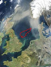
Dogger Bank
Dogger Bank is a large sandbank in a shallow area of the North Sea about off the east coast of England. It extends over approximately , with its dimensions being about long and up to broad. The water depth ranges from 15 to 36 metres , about shallower than the surrounding sea. It is a...
hill area into the east end of the Outer Silver Pit
Outer Silver Pit
The Outer Silver Pit is a west-to-east valley in the bed of the North Sea. Its widest part is 125 to 175 km east of Flamborough Head in England...
lake. It is named after Birmingham geologist Richard Shotton.
Disappearance
As sea levels rose after the end of the last glacial period of the current ice age, and the level of the land sank due to isostatic adjustmentPost-glacial rebound
Post-glacial rebound is the rise of land masses that were depressed by the huge weight of ice sheets during the last glacial period, through a process known as isostasy...
, Doggerland became submerged beneath the North Sea, cutting off what was previously the British peninsula from the European mainland by around 6500 BCE. The Dogger Bank
Dogger Bank
Dogger Bank is a large sandbank in a shallow area of the North Sea about off the east coast of England. It extends over approximately , with its dimensions being about long and up to broad. The water depth ranges from 15 to 36 metres , about shallower than the surrounding sea. It is a...
, which had been an upland area of Doggerland, is believed to have remained as an island until at least 5000 BCE.Before it flooded completely, Doggerland was a wide undulating plain containing complex meandering river systems, with associated channels and lakes. Key stages are now believed to include the gradual evolution of a large tidal embayment between eastern England and Dogger Bank by 7000 BCE, and rapid sea level rise thereafter, leading to the Dogger Bank becoming an island and Great Britain being finally physically disconnected from the continent.
A recent hypothesis is that much of the remaining coastal land, already much reduced in size from the original land area, was flooded by a tsunami
Tsunami
A tsunami is a series of water waves caused by the displacement of a large volume of a body of water, typically an ocean or a large lake...
around 8200BP (6200 BCE), caused by a submarine landslide off the coast of Norway
Norway
Norway , officially the Kingdom of Norway, is a Nordic unitary constitutional monarchy whose territory comprises the western portion of the Scandinavian Peninsula, Jan Mayen, and the Arctic archipelago of Svalbard and Bouvet Island. Norway has a total area of and a population of about 4.9 million...
known as the Storegga Slide
Storegga Slide
The three Storegga Slides are considered to be amongst the largest known landslides. They occurred under water, at the edge of Norway's continental shelf , in the Norwegian Sea, 100 km north-west of the Møre coast, causing a very large tsunami in the North Atlantic Ocean...
. This theory suggests "that the Storegga Slide tsunami would have had a catastrophic impact on the contemporary coastal Mesolithic population... Following the Storegga Slide tsunami, it appears, Britain finally became separated from the continent and, in cultural terms, the Mesolithic there goes its own way."
Discovery and investigation by archaeologists
The remains of plants brought to the surface from Dogger Bank had been studied as early as 1913 by palaeobiologistPaleobiology
Paleobiology is a growing and comparatively new discipline which combines the methods and findings of the natural science biology with the methods and findings of the earth science paleontology...
Clement Reid
Clement Reid
Clement Reid FRS was a British geologist and palaeobotanist.He was born in London in 1853. His great uncle was Michael Faraday. His family circumstances meant he was largely self-taught but he was nonetheless able to join the Geological Survey of Great Britain in 1874 and be employed in drawing up...
and the remains of animals and worked flints from the Neolithic period had been found around the fringes of the area. In his book The Antiquity of Man, published in 1915, anatomist
Anatomy
Anatomy is a branch of biology and medicine that is the consideration of the structure of living things. It is a general term that includes human anatomy, animal anatomy , and plant anatomy...
Sir Arthur Keith had discussed the archaeological potential of the area. In 1931, the trawler Colinda hauled up a lump of peat whilst fishing near the Ower Bank, 25 miles (40.2 km) east of Norfolk
Norfolk
Norfolk is a low-lying county in the East of England. It has borders with Lincolnshire to the west, Cambridgeshire to the west and southwest and Suffolk to the south. Its northern and eastern boundaries are the North Sea coast and to the north-west the county is bordered by The Wash. The county...
. The peat was found to contain a barbed antler point, possibly used as a harpoon
Harpoon
A harpoon is a long spear-like instrument used in fishing to catch fish or large marine mammals such as whales. It accomplishes this task by impaling the target animal, allowing the fishermen to use a rope or chain attached to the butt of the projectile to catch the animal...
or fish spear, 8.5 inches (21.6 cm) long, later identified to date from between 4,000 and 10,000 BCE, when the area was tundra
Tundra
In physical geography, tundra is a biome where the tree growth is hindered by low temperatures and short growing seasons. The term tundra comes through Russian тундра from the Kildin Sami word tūndâr "uplands," "treeless mountain tract." There are three types of tundra: Arctic tundra, alpine...
. The tool was exhibited in the Castle Museum in Norwich
Norwich
Norwich is a city in England. It is the regional administrative centre and county town of Norfolk. During the 11th century, Norwich was the largest city in England after London, and one of the most important places in the kingdom...
.
Interest in the area was reinvigorated in the 1990s by the work of Professor Bryony Coles, who named the area "Doggerland" ("after the great banks in
the southern North Sea") and produced a series of speculative maps of the area. Although she recognised that the current relief of the southern North Sea seabed
Seabed
The seabed is the bottom of the ocean.- Ocean structure :Most of the oceans have a common structure, created by common physical phenomena, mainly from tectonic movement, and sediment from various sources...
is not a sound guide to the topography of Doggerland, the topography of the area has more recently begun to be reconstructed more authoritatively using seismic survey
Reflection seismology
Reflection seismology is a method of exploration geophysics that uses the principles of seismology to estimate the properties of the Earth's subsurface from reflected seismic waves. The method requires a controlled seismic source of energy, such as dynamite/Tovex, a specialized air gun or a...
data obtained through petrochemical exploration surveys.
A skull fragment of a Neanderthal
Neanderthal
The Neanderthal is an extinct member of the Homo genus known from Pleistocene specimens found in Europe and parts of western and central Asia...
, dated at over 40,000 years old, was recovered from material dredged from the Middeldiep, a region of the North Sea some 10 miles (16.1 km) off the coast of Zeeland
Zeeland
Zeeland , also called Zealand in English, is the westernmost province of the Netherlands. The province, located in the south-west of the country, consists of a number of islands and a strip bordering Belgium. Its capital is Middelburg. With a population of about 380,000, its area is about...
, and was exhibited in Leiden in 2009.
In March 2010 it was reported that recognition of the potential archaeological importance of the area could affect the future development of offshore wind farms in the North Sea.
In popular culture
- The "Mammoth Journey" episode of the BBC television programme Walking with BeastsWalking with BeastsWalking with Beasts is a 2001 six-part television documentary miniseries, produced by the BBC in the United Kingdom, narrated by Kenneth Branagh. In North America it has been retitled Walking with Prehistoric Beasts, and the original Discovery Channel broadcast was narrated by Stockard Channing...
is partly set on the dry bed of the southern North Sea. - The area featured in the "Britain's Drowned World" episode of the Channel 4 Time TeamTime TeamTime Team is a British television series which has been aired on Channel 4 since 1994. Created by television producer Tim Taylor and presented by actor Tony Robinson, each episode features a team of specialists carrying out an archaeological dig over a period of three days, with Robinson explaining...
documentary series. - The first chapter of Edward RutherfurdEdward RutherfurdEdward Rutherfurd is a pen name for Francis Edward Wintle known primarily as a writer of epic historical novels...
's novel Sarum describes the flooding of Doggerland. - The legend "The Cormorants of Utrøst" describes a sunken land in the Norwegian SeaNorwegian SeaThe Norwegian Sea is a marginal sea in the North Atlantic Ocean, northwest of Norway. It is located between the North Sea and the Greenland Sea and adjoins the North Atlantic Ocean to the west and the Barents Sea to the northeast. In the southwest, it is separated from the Atlantic Ocean by a...
(not in the North Sea). - Science fictionScience fictionScience fiction is a genre of fiction dealing with imaginary but more or less plausible content such as future settings, futuristic science and technology, space travel, aliens, and paranormal abilities...
author Stephen BaxterStephen BaxterStephen Baxter is a prolific British hard science fiction author. He has degrees in mathematics and engineering.- Writing style :...
's Northland trilogy is set in an alternative timeline in which Doggerland (Northland in the books) is never inundated.
Further reading
- The Rediscovery of Doggerland, by Vincent Gaffney, Simon Fitch & David Smith, Council for British Archaeology, 2009, ISBN 190277177X
- Doggerland: a Speculative Survey, by B.J.Coles, Proceedings of the Prehistoric SocietyThe Prehistoric SocietyThe Prehistoric Society is an international learned society devoted to the study of the human past from the earliest times until the emergence of written history....
, 64 1998 pp 45–81. - Mapping Doggerland: The Mesolithic Landscapes of the Southern North Sea, V. Gaffney, K. Thomson and S. Fitch (editors), 2007, Archaeopress.
- Discussed in depth in chapters 2-4 in Before Scotland: The Story of Scotland Before History, Alistair Moffat, 2005, Thames & Hudson Inc. ISBN 978-0-500-05133-7
External links
- BBC: The moment Britain became an island
- BBC Radio 4: Doggerland
- University of Birmingham: North Sea Paleolandscapes website
- Doggerland on Zinken
- English Heritage: North Sea coastal peat resource database
- Map of North Sea area shortly before the Dogger Bank island was cut off from the mainland
- Doggerland: A project aiming to mark Doggerland on the contemporary map of Europe
- CGI images (2 stills and a movie) of a MesolithicMesolithicThe Mesolithic is an archaeological concept used to refer to certain groups of archaeological cultures defined as falling between the Paleolithic and the Neolithic....
camp beside the Shotton River, and a list of relevant links to press releases. - 6 CGI images of Doggerland landscape (comments in German)