

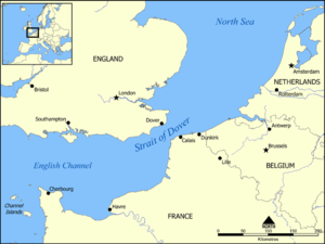
Strait of Dover
Encyclopedia
Strait
A strait or straits is a narrow, typically navigable channel of water that connects two larger, navigable bodies of water. It most commonly refers to a channel of water that lies between two land masses, but it may also refer to a navigable channel through a body of water that is otherwise not...
at the narrowest part of the English Channel
English Channel
The English Channel , often referred to simply as the Channel, is an arm of the Atlantic Ocean that separates southern England from northern France, and joins the North Sea to the Atlantic. It is about long and varies in width from at its widest to in the Strait of Dover...
. The shortest distance across the strait is from the South Foreland
South Foreland
South Foreland is a chalk headland on the Kent coast of southeast England. It presents a bold cliff to the sea, and commands views over the Strait of Dover. It is northeast of Dover and 15 miles south of North Foreland...
, 6 kilometres (some 4 miles) northeast of Dover
Dover
Dover is a town and major ferry port in the home county of Kent, in South East England. It faces France across the narrowest part of the English Channel, and lies south-east of Canterbury; east of Kent's administrative capital Maidstone; and north-east along the coastline from Dungeness and Hastings...
in the county of Kent
Kent
Kent is a county in southeast England, and is one of the home counties. It borders East Sussex, Surrey and Greater London and has a defined boundary with Essex in the middle of the Thames Estuary. The ceremonial county boundaries of Kent include the shire county of Kent and the unitary borough of...
, England, to Cap Gris Nez
Cap Gris Nez
Cap Gris Nez is a cape on the Côte d'Opale in the Pas-de-Calais département in northern France....
, a cape
Headlands and bays
Headlands and bays are two related features of the coastal environment.- Geology and geography :Headlands and bays are often found on the same coastline. A bay is surrounded by land on three sides, whereas a headland is surrounded by water on three sides. Headlands are characterized by high,...
near to Calais
Calais
Calais is a town in Northern France in the department of Pas-de-Calais, of which it is a sub-prefecture. Although Calais is by far the largest city in Pas-de-Calais, the department's capital is its third-largest city of Arras....
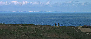
in the French of Pas-de-Calais, France. Between these two points lies the most popular route for cross-channel swimmers as the distance is reduced to 34 km (21.1 mi).
On a clear day, it is possible to see the opposite coastline and shoreline buildings with the naked eye, and the lights of land at night, as in Matthew Arnold
Matthew Arnold
Matthew Arnold was a British poet and cultural critic who worked as an inspector of schools. He was the son of Thomas Arnold, the famed headmaster of Rugby School, and brother to both Tom Arnold, literary professor, and William Delafield Arnold, novelist and colonial administrator...
's poem "Dover Beach
Dover Beach
"Dover Beach" is a short lyric poem by the English poet Matthew Arnold. It was first published in 1867 in the collection New Poems, but surviving notes indicate its composition may have begun as early as 1849...
".
Shipping traffic
Atlantic Ocean
The Atlantic Ocean is the second-largest of the world's oceanic divisions. With a total area of about , it covers approximately 20% of the Earth's surface and about 26% of its water surface area...
and the North
North Sea
In the southwest, beyond the Straits of Dover, the North Sea becomes the English Channel connecting to the Atlantic Ocean. In the east, it connects to the Baltic Sea via the Skagerrak and Kattegat, narrow straits that separate Denmark from Norway and Sweden respectively...
and Baltic Sea
Baltic Sea
The Baltic Sea is a brackish mediterranean sea located in Northern Europe, from 53°N to 66°N latitude and from 20°E to 26°E longitude. It is bounded by the Scandinavian Peninsula, the mainland of Europe, and the Danish islands. It drains into the Kattegat by way of the Øresund, the Great Belt and...
s passes through the Strait of Dover, rather than taking the longer and more dangerous route around the north of Scotland
Scotland
Scotland is a country that is part of the United Kingdom. Occupying the northern third of the island of Great Britain, it shares a border with England to the south and is bounded by the North Sea to the east, the Atlantic Ocean to the north and west, and the North Channel and Irish Sea to the...
. The strait is the busiest international seaway in the world, used by over 400 commercial vessels daily. This has made safety a critical issue, with HM Coastguard
Her Majesty's Coastguard
Her Majesty's Coastguard is the service of the government of the United Kingdom concerned with co-ordinating air-sea rescue.HM Coastguard is a section of the Maritime and Coastguard Agency responsible for the initiation and co-ordination of all civilian maritime Search and Rescue within the UK...
maintaining a 24-hour watch over the strait and enforcing a strict regime of shipping lanes.
In addition to the intensive east-west traffic, the strait is criss-crossed from north to south by ferries
Ferry
A ferry is a form of transportation, usually a boat, but sometimes a ship, used to carry primarily passengers, and sometimes vehicles and cargo as well, across a body of water. Most ferries operate on regular, frequent, return services...
linking Dover
Dover
Dover is a town and major ferry port in the home county of Kent, in South East England. It faces France across the narrowest part of the English Channel, and lies south-east of Canterbury; east of Kent's administrative capital Maidstone; and north-east along the coastline from Dungeness and Hastings...
to Calais
Calais
Calais is a town in Northern France in the department of Pas-de-Calais, of which it is a sub-prefecture. Although Calais is by far the largest city in Pas-de-Calais, the department's capital is its third-largest city of Arras....
and Boulogne. Until the 1990s these provided the only surface-based route across it. The Channel Tunnel
Channel Tunnel
The Channel Tunnel is a undersea rail tunnel linking Folkestone, Kent in the United Kingdom with Coquelles, Pas-de-Calais near Calais in northern France beneath the English Channel at the Strait of Dover. At its lowest point, it is deep...
now provides an alternative route, crossing underneath the strait at an average depth of 45 m (150 feet) underneath the seabed.
The town of Dover gives its name to one of the sea areas of the British Shipping Forecast
Shipping Forecast
The Shipping Forecast is a four-times-daily BBC Radio broadcast of weather reports and forecasts for the seas around the coasts of the British Isles. It is produced by the Met Office and broadcast by BBC Radio 4 on behalf of the Maritime and Coastguard Agency. The forecasts sent over the Navtex...
.
Geological formation

Erosion
Erosion is when materials are removed from the surface and changed into something else. It only works by hydraulic actions and transport of solids in the natural environment, and leads to the deposition of these materials elsewhere...
. At one time there was land where the strait is now, a south-east extension of the Weald
Weald
The Weald is the name given to an area in South East England situated between the parallel chalk escarpments of the North and the South Downs. It should be regarded as three separate parts: the sandstone "High Weald" in the centre; the clay "Low Weald" periphery; and the Greensand Ridge which...
joining what is now Great Britain
Great Britain
Great Britain or Britain is an island situated to the northwest of Continental Europe. It is the ninth largest island in the world, and the largest European island, as well as the largest of the British Isles...
to continental Europe
Continental Europe
Continental Europe, also referred to as mainland Europe or simply the Continent, is the continent of Europe, explicitly excluding European islands....
. The eastern end of this old longer Weald is the Boulonnais
Boulonnais (land area)
The Boulonnais is a coastal area of northern France, around Calais and Boulogne-sur-Mer. It has a curved belt of chalk downs which run into the sea at both ends, and geologically is the east end of the Weald-Artois Anticline.- Administration :...
chalk area in the Pas de Calais. The predominant geology on both the British and French sides and on the sea floor between is chalk
Chalk
Chalk is a soft, white, porous sedimentary rock, a form of limestone composed of the mineral calcite. Calcite is calcium carbonate or CaCO3. It forms under reasonably deep marine conditions from the gradual accumulation of minute calcite plates shed from micro-organisms called coccolithophores....
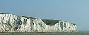
. Although somewhat resistant to erosion, such erosion of the chalk can be seen on both coasts as impressive sea cliff
Cliff
In geography and geology, a cliff is a significant vertical, or near vertical, rock exposure. Cliffs are formed as erosion landforms due to the processes of erosion and weathering that produce them. Cliffs are common on coasts, in mountainous areas, escarpments and along rivers. Cliffs are usually...
s, the famous white cliffs of Dover
White cliffs of Dover
The White Cliffs of Dover are cliffs which form part of the British coastline facing the Strait of Dover and France. The cliffs are part of the North Downs formation. The cliff face, which reaches up to , owes its striking façade to its composition of chalk accentuated by streaks of black flint...
, and Cap Blanc Nez
Cap Blanc Nez
Cap Blanc Nez is a cape on the Côte d'Opale, in the Pas-de-Calais département, in northern France. The cliffs of chalk are very similar to the white cliffs of Dover at the other side of the Channel in England...
on the French side of the strait. This same rock provided an excellent tunnelling medium for the Channel Tunnel
Channel Tunnel
The Channel Tunnel is a undersea rail tunnel linking Folkestone, Kent in the United Kingdom with Coquelles, Pas-de-Calais near Calais in northern France beneath the English Channel at the Strait of Dover. At its lowest point, it is deep...
.

Pleistocene
The Pleistocene is the epoch from 2,588,000 to 11,700 years BP that spans the world's recent period of repeated glaciations. The name pleistocene is derived from the Greek and ....
Ice Age
Ice age
An ice age or, more precisely, glacial age, is a generic geological period of long-term reduction in the temperature of the Earth's surface and atmosphere, resulting in the presence or expansion of continental ice sheets, polar ice sheets and alpine glaciers...
s. The ice created a dam
Dam
A dam is a barrier that impounds water or underground streams. Dams generally serve the primary purpose of retaining water, while other structures such as floodgates or levees are used to manage or prevent water flow into specific land regions. Hydropower and pumped-storage hydroelectricity are...
from Scandinavia
Scandinavia
Scandinavia is a cultural, historical and ethno-linguistic region in northern Europe that includes the three kingdoms of Denmark, Norway and Sweden, characterized by their common ethno-cultural heritage and language. Modern Norway and Sweden proper are situated on the Scandinavian Peninsula,...
to Scotland
Scotland
Scotland is a country that is part of the United Kingdom. Occupying the northern third of the island of Great Britain, it shares a border with England to the south and is bounded by the North Sea to the east, the Atlantic Ocean to the north and west, and the North Channel and Irish Sea to the...
, and the Rhine, combined with the Thames and drainage from much of north Europe, created a vast lake behind the dam, which eventually spilled over the Weald into the English Channel
English Channel
The English Channel , often referred to simply as the Channel, is an arm of the Atlantic Ocean that separates southern England from northern France, and joins the North Sea to the Atlantic. It is about long and varies in width from at its widest to in the Strait of Dover...
. This overflow channel was gradually widened and deepened into the Strait of Dover. A narrow deeper channel along the middle of the strait was the bed of the Rhine in the last Ice Age. In East Anglia
East Anglia
East Anglia is a traditional name for a region of eastern England, named after an ancient Anglo-Saxon kingdom, the Kingdom of the East Angles. The Angles took their name from their homeland Angeln, in northern Germany. East Anglia initially consisted of Norfolk and Suffolk, but upon the marriage of...
there is a geological deposit that marks the old preglacial northward course of the Rhine.
However, a new study by Gupta et al. (2007) suggests that the English Channel was formed by erosion caused by two major floods. The first was about 425 000 years ago, when an ice-dammed lake in the southern North Sea overflowed and broke the Weald-Artois
Artois
Artois is a former province of northern France. Its territory has an area of around 4000 km² and a population of about one million. Its principal cities are Arras , Saint-Omer, Lens and Béthune.-Location:...
chalk range in a catastrophic erosion and flood event. Afterwards, the Thames and Scheldt
Scheldt
The Scheldt is a 350 km long river in northern France, western Belgium and the southwestern part of the Netherlands...
flowed through the gap into the English Channel, but the Meuse
Meuse River
The Maas or Meuse is a major European river, rising in France and flowing through Belgium and the Netherlands before draining into the North Sea...
and Rhine still flowed northwards. In a second flood about 225 000 years ago the Meuse and Rhine were ice-dammed into a lake that broke catastrophically through a high weak barrier (perhaps chalk, or an end-moraine left by the ice sheet). Both floods cut massive flood channels in the dry bed of the English Channel, somewhat like the Channeled Scablands
Channeled scablands
The Channeled Scablands are a unique geological erosion feature in the U.S. state of Washington. They were created by the cataclysmic Missoula Floods that swept periodically across eastern Washington and down the Columbia River Plateau during the Pleistocene epoch. Geologist J Harlen Bretz coined...
or the Wabash river
Wabash River
The Wabash River is a river in the Midwestern United States that flows southwest from northwest Ohio near Fort Recovery across northern Indiana to southern Illinois, where it forms the Illinois-Indiana border before draining into the Ohio River, of which it is the largest northern tributary...
in the USA.
Unusual crossings
Many crossings other than in conventional vessels have been attempted, including by pedaloPedalo
A paddle boat or "pedalo" is a form of waterborne transport, primarily for recreational use, powered through the use of pedals....
, bathtub
Bathtub
A bath , bathtub , or tub is a large container for holding water in which a person may bathe . Most modern bathtubs are made of acrylic or fiberglass, but alternatives are available in enamel over steel or cast iron, and occasionally waterproof finished wood...
, amphibious vehicle
Amphibious vehicle
An amphibious vehicle , is a vehicle or craft, that is a means of transport, viable on land as well as on water – just like an amphibian....
and more commonly by swimming. French law bans many of these that British law does not, so most such crossings originate in England.