
Cyclone Monica
Encyclopedia
Severe Tropical Cyclone Monica was the most intense tropical cyclone
, in terms of maximum sustained wind
s, on record to impact Australia. The 17th storm of the 2005–06 Australian region cyclone season, Monica originated from an area of low pressure
off the coast of Papua New Guinea
on 16 April. The storm quickly developed into a Category 1 cyclone the next day, at which time it was given the name Monica. Travelling towards the west, the storm intensified into a severe tropical cyclone before making landfall in Far North Queensland
, near the Lockhart River, on 19 April. After moving over land, convection
associated with the storm quickly became disorganised.
On 20 April, Monica emerged into the Gulf of Carpentaria
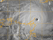
and began to re-intensify. Over the following few days, deep convection formed around a 37 km (23 mi) wide eye
. Early on 22 April, the Bureau of Meteorology (BoM) assessed Monica to have attained Category 5 status, on the Australian cyclone intensity scale. The Joint Typhoon Warning Center
(JTWC) also upgraded Monica to a Category 5 equivalent cyclone, on the Saffir–Simpson Hurricane Scale. The storm attained its peak intensity the following day with winds of 250 km/h (155 km/h 10-minute winds) and a barometric pressure of 916 mbar
(hPa
; 27.05 inHg). On 24 April, Monica made landfall about 35 km (21.7 mi) west of Maningrida
, at the same intensity. Rapid weakening took place as the storm moved over land. Less than 24 hours after landfall, the storm had weakened to a tropical low. The remnants of the former-Category 5 cyclone persisted until 28 April over northern Australia.
In contrast to the extreme intensity of the cyclone, relatively little structural damage resulted from it. No injuries were reported to have occurred during the storm's existence and losses were estimated to be A$
6.6 million (US$5.1 million). However, severe environmental damage took place. In the Northern Territory, an area about 7,000 km2 (4,300 mi2) was defoliated by Monica's high wind gusts. In response to the large loss of forested area, it was stated that it would take several hundred years for the area to reflourish.
that formed early on 16 April off the coast of Papua New Guinea
. The low quickly became organised, with deep convection
developing over the low-pressure centre. Later that day, the Joint Typhoon Warning Center
(JTWC) issued a Tropical Cyclone Formation Alert
as the system became increasingly organised. Early the next day, the Bureau of Meteorology in Brisbane, Australia declared that the low had developed into a Category 1 cyclone on the Australian tropical cyclone scale, with winds reaching 65 km/h (40 mph 10-minute sustained). Upon being classified as a cyclone, the storm was given the name Monica. At the same time, the JWTC designated Monica as Tropical Cyclone 23P. Monica tracked generally westward, towards Far North Queensland
, in response to a low to mid-level ridge
to the south.
Low wind shear
and good divergence
in the path of the storm allowed for continued intensification as continued westward. Late on 17 April, Monica intensified into a Category 2 Cyclone, with winds reaching 95 km/h (60 mph 10-minute sustained). By 1200 UTC on 18 April, the Bureau of Meteorology upgraded Monica to a severe tropical cyclone, a Category 3 on the Australian scale. This followed an increase in the storm's outflow
and a fluctuating central dense overcast. Several hours later, the JTWC upgraded Monica to the equivalent of a Category 1 hurricane on the Saffir–Simpson Hurricane Scale. During the afternoon of 19 April, the storm made landfall
roughly 40 km (24.9 mi) south-southeast of the Lockhart River with winds of 130 km/h (80 mph 10-minute sustained). At the same time, the JTWC assessed Monica to have intensified into a Category 2 equivalent storm with winds of 155 km/h (100 mph 1-minute sustained).
Shortly after making landfall, convection associated with the storm deteriorated and the outflow became fragmented. A shortwave trough
to the south caused the ridge steering Monica to weaken, leading to the cyclone moving slower. After moving over land, the storm began to weaken, with the Bureau of Meteorology downgrading the storm to weaken to Category 1 cyclone and the JTWC downgraded the cyclone to a tropical storm. The following day, Monica moved offshore, entering the Gulf of Carpentaria
. Once back over water, favourable atmospheric conditions allowed the storm to quickly intensify. Within 24-hours of moving over water, Monica re-attained severe tropical cyclone status. Following a shift in steering currents, the storm slowed significantly and turned north-westward. Steady intensification continued through 22 April as the storm remained in a region of low wind shear and favourable diffluence
. Early on 22 April the Bureau of Meteorology upgraded Monica to a Category 5 severe tropical cyclone, the third of the season. By this time, a 37 km (23 mi) wide eye
had developed within the central dense overcast of the cyclone. Later that day, the JTWC assessed Monica to have intensified into a Category 5 equivalent storm.
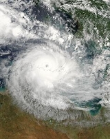
 Cyclone Monica attained its peak intensity on 23 April near Cape Wessel
with a barometric pressure 916 mbar
(hPa
; 27.05 inHg). Maximum winds were estimated at 250 km/h (155 mph 10-minute sustained) by the Bureau of Meteorology while the JTWC assessed it to have attained winds of 285 km/h (180 mph 1-minute sustained). Using the dvorak technique
, the peak intensity of the cyclone was estimated over 320 km/h (198.8 mph) along with a minimum pressure below 869 mbar (hPa; 25.66 inHg). At its peak, Monica exceeded a T# of 8.0, the highest ranking on the Dvorak Scale. However, since the JTWC is not the official warning centre for Australian cyclones, these intensities remain unofficial.
On 24 April, the mid-level ridge south of Monica weakened, causing the storm to turn towards the south-west. Following this, the storm made landfall in the Northern Territory
, roughly 35 km (21.7 mi) west of Maningrida
, as a Category 5 cyclone with winds of 250 km/h (155 mph 10-minute sustained). Not long after making landfall, the storm weakened extremely quickly. Most convective activity associated with the storm dissipated within nine hours of moving onshore. This resulted in the storm's maximum winds decreasing by 155 km/h (100 mph) in a 12-hour span. After this rapid weakening, the storm turned sharply west moving over the town of Jabiru
as a Category 2 cyclone. Within six hours of passing this town, the Bureau of Meteorology downgraded Monica to a tropical low, no longer producing gale-force winds. The JTWC issued their final advisory on the storm at 1800 UTC that day. The remnants of Monica persisted for several more days, tracking near Darwin
on 25 April before turning south-east and accelerating over the Northern Territory. The remnants eventually dissipated on 28 April over central Australia.
The Bureau of Meteorology uses 10-minute sustained winds
, while the Joint Typhoon Warning Center uses one-minute sustained winds. The Bureau of Meteorology's peak intensity for Monica was 250 km/h (155 mph) 10-minute sustained, or 285 km/h (180 mph) one-minute sustained. The JTWC's peak intensity for Monica was 285 km/h (180 mph) one-minute sustained, or 250 km/h (155 mph) 10-minute sustained.
before officials shut down major highways in the area. Ferry services in the Great Barrier Reef
and flights in and out of the region were cancelled. However, no evacuations took place according to the Emergency Management in Australia. An aborigine community of 700, located around the mouth of the Lockhart River, were in the direct path of the storm. The chief executive officer of the community stated that they were ready for the storm, having suffered no losses from Cyclone Ingrid
which impacted the same area in 2005.
Little damage was recorded in Queensland, despite Cyclone Monica being a Category 3 cyclone, as the storm impacted a sparsely populated region of the Cape York peninsula
. A storm surge
of 1.23 m (4 ft) was recorded in Mossman
and waves were recorded up to 4.24 m (13.91 ft) in Weipa
. Heavy rainfall was also associated with the storm, exceeding 400 mm (15.7 in) near where Monica made landfall. Wind gusts up to 109 km/h (67.7 mph) were recorded as the storm traversed the peninsula. Officials reported about 15% of the structures along the Lockhart River sustained minor damages and no fatalities were caused as a result of the cyclone. Minor coastal flooding was also reported due to Monica. Three Torres Strait Islanders
were rescued after 22 days drifting at sea in the wake of the cyclone passing through the Torres Strait
, north of mainland Queensland.
march. Alcan
, the world's second-largest aluminium
producer, warned customers of potential interruptions to supplies on contracts from its Gove refinery. Rio Tinto
's Ranger Uranium Mine
ceased operations on 24 April, "as a precautionary measure".
At one point, Monica was forecast to pass directly over Goulburn Island. In response, officials evacuated the island's 337 residents to shelters set up in Pine Creek. Numerous schools in the threatened region, especially in Darwin, were closed ahead of Monica's arrival. Several shelters were opened in Darwin early on 24 April in anticipation of an influx of evacuees. Stores throughout the area reported increased sales for storm supplies, with some reducing prices on specific items. The same day, the Darwin Returned and Services League of Australia
cancelled all ANZAC Day
services and marches in Darwin that were to be held the next day, to ensure the safety of prospective participants.
 The Wessel Islands
, located off the coast of the region, suffered significant damage from the storm. Mangrove trees were uprooted throughout the islands and sand dunes were destroyed. An outstation located on one of the islands was destroyed by the cyclone. The highest 24-hour rainfall from the storm was recorded near Darwin at 340 mm (13.4 in). A storm total for the same area was recorded at 383 mm (15.1 in), surpassing the rainfall record for the entire month of April set in 1953. Although the storm made landfall at peak intensity in Australia's Northern Territory
, the impacted areas were sparsely populated. Around the region where Monica made landfall, evidence of a 5–6 m (16.4–19.6 ft) storm surge
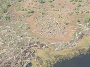
was present in Junction Bay. Along an area 50 km (31.1 mi) wide and 130 km (80.8 mi) long, countless trees were snapped or uprooted by the storm. Nearly 70% of the forested areas around the bay were destroyed or defoliated by the storms' 360 km/h (225 mph) wind gusts. An estimated 7,000 km2 (4,350 mi2) of trees were downed by the storm with large areas of trees being uprooted.
Power lines were felled by high winds in Maningrida
, 12 homes sustained damage from fallen trees in Jabiru
, and extensive damage was reported in Oenpelli
. Roughly 1,000 people also lost phone service in the region. Several highways were blocked by fallen trees throughout the area. A resort in Jabiru sustained significant damage and was closed for two weeks following the storm. Insured damages to the national parks amounted to A$1.6 million (US$766,000). According to the Northern Territory Insurance Office, structural damage from Cyclone Monica amounted to A$5 million (US$4.4 million). The remnants of Monica produced significant rainfall over parts of the Northern Territory several days after the system weakened below cyclone status. Flash flooding was reported throughout the Adelaide River basin as up to 261 mm (10.3 in) of rain fell in a 24-hour span. On 26 April, the remnants of Monica spawned a small tornado
near Channel Point; several mangrove trees were snapped and branches were thrown to nearby beaches.
which caused significant damage in Queensland
. The Government of Australia assisted affected business by providing disaster loans up to A$25,000 for severely impacted areas and A$10,000 for less affected areas. Farmers were also provided with up to $200,000 in loans over a period of nine years. Following the impacts in the Northern Territory, two cleanup teams were dispatched from Darwin
to assist in cleanup efforts in the hardest hit regions. In a study of the Arnhem forests which were devastated by the cyclone, environmentalists reported that it would take over 100 years for the forest to recover. The storm's winds snapped numerous trees, estimated to have been over 200 years old and more than 60 cm (23.6 in) in diameter. It is estimated that it would take several hundred years before trees of similar sizes would flourish in the region. Despite the minimal damage caused by Monica, the name was retired from the circulating lists of tropical cyclone names for the Australian Region.
Within weeks of the storm, the Alligator Rivers Region Advisory Committee began planting seedlings in deforested areas. By August 2006, a review of the growth of the new plants found that 81% to 88% of the seeds had survived and begun growing. To fully restore the South Alligator valley, environmentalists requested A$7.4 million (US$6.6 million) in funds. In a study at Magela Creek a year after the storm, it was determined that between 8% and 19% of the tree canopy lost due to the storm had begun to recover. Additional studies at the Gulungul Creek and the Alligator Rivers region revealed that suspended sediment values in flowing water had temporarily increased in the wake of Monica. The above-average values persisted for roughly a year before the streams returned to pre-cyclone sediment levels.
Upon making landfall on 24 April, Monica became the strongest known storm to impact the Northern Territory on record. Maximum sustained winds were estimated at 250 km/h (155 mph 10-minute sustained) by the Bureau of Meteorology and 285 km/h (180 mph 1-minute sustained) by the JTWC. According to the JTWC, Monica had a minimum barometric pressure of 879 hPa (mbar), ranking Monica as the strongest storm recorded in the southern hemisphere alongside Cyclone Zoe
of 2002. Additionally, using the Dvorak technique
, the peak intensity of the cyclone was estimated over 320 km/h (198.8 mph) along with a minimum pressure below 869 hPa (mbar). At its peak, Monica exceeded a T# of 8.0, the highest ranking on the Dvorak Scale. Although unofficial, this would make Monica the strongest known tropical cyclone in history, eclipsing Typhoon Tip
of 1979
.
World Meteorological Organization
Australian Bureau of Meteorology
Joint Typhoon Warning Center (JTWC)
BoM Report
Tropical cyclone
A tropical cyclone is a storm system characterized by a large low-pressure center and numerous thunderstorms that produce strong winds and heavy rain. Tropical cyclones strengthen when water evaporated from the ocean is released as the saturated air rises, resulting in condensation of water vapor...
, in terms of maximum sustained wind
Maximum sustained wind
The maximum sustained winds associated with a tropical cyclone are a common indicator of the intensity of the storm. Within a mature tropical cyclone, they are found within the eyewall at a distance defined as the radius of maximum wind, or RMW. Unlike gusts, the value of these winds are...
s, on record to impact Australia. The 17th storm of the 2005–06 Australian region cyclone season, Monica originated from an area of low pressure
Low pressure area
A low-pressure area, or "low", is a region where the atmospheric pressure at sea level is below that of surrounding locations. Low-pressure systems form under areas of wind divergence which occur in upper levels of the troposphere. The formation process of a low-pressure area is known as...
off the coast of Papua New Guinea
Papua New Guinea
Papua New Guinea , officially the Independent State of Papua New Guinea, is a country in Oceania, occupying the eastern half of the island of New Guinea and numerous offshore islands...
on 16 April. The storm quickly developed into a Category 1 cyclone the next day, at which time it was given the name Monica. Travelling towards the west, the storm intensified into a severe tropical cyclone before making landfall in Far North Queensland
Far North Queensland
Far North Queensland, or FNQ, is the northernmost part of the Australian state of Queensland. The region, which contains a large section of the Tropical North Queensland area, stretches from the city of Cairns north to the Torres Strait...
, near the Lockhart River, on 19 April. After moving over land, convection
Atmospheric convection
Atmospheric convection is the result of a parcel-environment instability, or temperature difference, layer in the atmosphere. Different lapse rates within dry and moist air lead to instability. Mixing of air during the day which expands the height of the planetary boundary layer leads to...
associated with the storm quickly became disorganised.
On 20 April, Monica emerged into the Gulf of Carpentaria
Gulf of Carpentaria
The Gulf of Carpentaria is a large, shallow sea enclosed on three sides by northern Australia and bounded on the north by the Arafura Sea...
and began to re-intensify. Over the following few days, deep convection formed around a 37 km (23 mi) wide eye
Eye (cyclone)
The eye is a region of mostly calm weather found at the center of strong tropical cyclones. The eye of a storm is a roughly circular area and typically 30–65 km in diameter. It is surrounded by the eyewall, a ring of towering thunderstorms where the second most severe weather of a cyclone...
. Early on 22 April, the Bureau of Meteorology (BoM) assessed Monica to have attained Category 5 status, on the Australian cyclone intensity scale. The Joint Typhoon Warning Center
Joint Typhoon Warning Center
The Joint Typhoon Warning Center is a joint United States Navy – United States Air Force task force located at the Naval Maritime Forecast Center in Pearl Harbor, Hawaii...
(JTWC) also upgraded Monica to a Category 5 equivalent cyclone, on the Saffir–Simpson Hurricane Scale. The storm attained its peak intensity the following day with winds of 250 km/h (155 km/h 10-minute winds) and a barometric pressure of 916 mbar
Bar (unit)
The bar is a unit of pressure equal to 100 kilopascals, and roughly equal to the atmospheric pressure on Earth at sea level. Other units derived from the bar are the megabar , kilobar , decibar , centibar , and millibar...
(hPa
Pascal (unit)
The pascal is the SI derived unit of pressure, internal pressure, stress, Young's modulus and tensile strength, named after the French mathematician, physicist, inventor, writer, and philosopher Blaise Pascal. It is a measure of force per unit area, defined as one newton per square metre...
; 27.05 inHg). On 24 April, Monica made landfall about 35 km (21.7 mi) west of Maningrida
Maningrida, Northern Territory
Maningrida is a self-governing indigenous community in the heart of the Arnhem Land region of Australia's Northern Territory. Maningrida is located 500 km east of Darwin and 300 km north east of Jabiru. It is on the North Central Arnhem Land coast of the Arafura Sea, on the estuary of the Liverpool...
, at the same intensity. Rapid weakening took place as the storm moved over land. Less than 24 hours after landfall, the storm had weakened to a tropical low. The remnants of the former-Category 5 cyclone persisted until 28 April over northern Australia.
In contrast to the extreme intensity of the cyclone, relatively little structural damage resulted from it. No injuries were reported to have occurred during the storm's existence and losses were estimated to be A$
Australian dollar
The Australian dollar is the currency of the Commonwealth of Australia, including Christmas Island, Cocos Islands, and Norfolk Island, as well as the independent Pacific Island states of Kiribati, Nauru and Tuvalu...
6.6 million (US$5.1 million). However, severe environmental damage took place. In the Northern Territory, an area about 7,000 km2 (4,300 mi2) was defoliated by Monica's high wind gusts. In response to the large loss of forested area, it was stated that it would take several hundred years for the area to reflourish.
Meteorological history
Severe Tropical Cyclone Monica originated from an area of low pressureLow pressure area
A low-pressure area, or "low", is a region where the atmospheric pressure at sea level is below that of surrounding locations. Low-pressure systems form under areas of wind divergence which occur in upper levels of the troposphere. The formation process of a low-pressure area is known as...
that formed early on 16 April off the coast of Papua New Guinea
Papua New Guinea
Papua New Guinea , officially the Independent State of Papua New Guinea, is a country in Oceania, occupying the eastern half of the island of New Guinea and numerous offshore islands...
. The low quickly became organised, with deep convection
Atmospheric convection
Atmospheric convection is the result of a parcel-environment instability, or temperature difference, layer in the atmosphere. Different lapse rates within dry and moist air lead to instability. Mixing of air during the day which expands the height of the planetary boundary layer leads to...
developing over the low-pressure centre. Later that day, the Joint Typhoon Warning Center
Joint Typhoon Warning Center
The Joint Typhoon Warning Center is a joint United States Navy – United States Air Force task force located at the Naval Maritime Forecast Center in Pearl Harbor, Hawaii...
(JTWC) issued a Tropical Cyclone Formation Alert
Tropical Cyclone Formation Alert
A Tropical Cyclone Formation Alert is a bulletin released by the U.S. Navy-operated Joint Typhoon Warning Center in Honolulu, Hawaii or the Naval Maritime Forecast Center in Norfolk, Virginia, warning of the possibility of a tropical cyclone forming from a tropical disturbance that has been...
as the system became increasingly organised. Early the next day, the Bureau of Meteorology in Brisbane, Australia declared that the low had developed into a Category 1 cyclone on the Australian tropical cyclone scale, with winds reaching 65 km/h (40 mph 10-minute sustained). Upon being classified as a cyclone, the storm was given the name Monica. At the same time, the JWTC designated Monica as Tropical Cyclone 23P. Monica tracked generally westward, towards Far North Queensland
Far North Queensland
Far North Queensland, or FNQ, is the northernmost part of the Australian state of Queensland. The region, which contains a large section of the Tropical North Queensland area, stretches from the city of Cairns north to the Torres Strait...
, in response to a low to mid-level ridge
Ridge (meteorology)
A ridge is an elongated region of relatively high atmospheric pressure, the opposite of a trough....
to the south.
Low wind shear
Wind shear
Wind shear, sometimes referred to as windshear or wind gradient, is a difference in wind speed and direction over a relatively short distance in the atmosphere...
and good divergence
Divergence
In vector calculus, divergence is a vector operator that measures the magnitude of a vector field's source or sink at a given point, in terms of a signed scalar. More technically, the divergence represents the volume density of the outward flux of a vector field from an infinitesimal volume around...
in the path of the storm allowed for continued intensification as continued westward. Late on 17 April, Monica intensified into a Category 2 Cyclone, with winds reaching 95 km/h (60 mph 10-minute sustained). By 1200 UTC on 18 April, the Bureau of Meteorology upgraded Monica to a severe tropical cyclone, a Category 3 on the Australian scale. This followed an increase in the storm's outflow
Outflow (meteorology)
Outflow, in meteorology, is air that flows outwards from a storm system. It is associated with ridging, or anticyclonic flow. In the low levels of the troposphere, outflow radiates from thunderstorms in the form of a wedge of rain-cooled air, which is visible as a thin rope-like cloud on weather...
and a fluctuating central dense overcast. Several hours later, the JTWC upgraded Monica to the equivalent of a Category 1 hurricane on the Saffir–Simpson Hurricane Scale. During the afternoon of 19 April, the storm made landfall
Landfall (meteorology)
Landfall is the event of a tropical cyclone or a waterspout coming onto land after being over water. When a waterspout makes landfall it is reclassified as a tornado, which can then cause damage inland...
roughly 40 km (24.9 mi) south-southeast of the Lockhart River with winds of 130 km/h (80 mph 10-minute sustained). At the same time, the JTWC assessed Monica to have intensified into a Category 2 equivalent storm with winds of 155 km/h (100 mph 1-minute sustained).
Shortly after making landfall, convection associated with the storm deteriorated and the outflow became fragmented. A shortwave trough
Shortwave (meteorology)
A shortwave or shortwave trough is an embedded kink in the trough / ridge pattern. This is the opposite of longwaves, which are responsible for synoptic scale systems, although shortwaves may be contained within or found ahead of longwaves and range from the mesocale to the synoptic scale...
to the south caused the ridge steering Monica to weaken, leading to the cyclone moving slower. After moving over land, the storm began to weaken, with the Bureau of Meteorology downgrading the storm to weaken to Category 1 cyclone and the JTWC downgraded the cyclone to a tropical storm. The following day, Monica moved offshore, entering the Gulf of Carpentaria
Gulf of Carpentaria
The Gulf of Carpentaria is a large, shallow sea enclosed on three sides by northern Australia and bounded on the north by the Arafura Sea...
. Once back over water, favourable atmospheric conditions allowed the storm to quickly intensify. Within 24-hours of moving over water, Monica re-attained severe tropical cyclone status. Following a shift in steering currents, the storm slowed significantly and turned north-westward. Steady intensification continued through 22 April as the storm remained in a region of low wind shear and favourable diffluence
Deformation (meteorology)
Deformation is the rate of change of shape of fluid bodies. Meteorologically, this quantity is very important in the formation of atmospheric fronts, in the explanation of cloud shapes, and in the diffusion of materials and properties.-Equations:...
. Early on 22 April the Bureau of Meteorology upgraded Monica to a Category 5 severe tropical cyclone, the third of the season. By this time, a 37 km (23 mi) wide eye
Eye (cyclone)
The eye is a region of mostly calm weather found at the center of strong tropical cyclones. The eye of a storm is a roughly circular area and typically 30–65 km in diameter. It is surrounded by the eyewall, a ring of towering thunderstorms where the second most severe weather of a cyclone...
had developed within the central dense overcast of the cyclone. Later that day, the JTWC assessed Monica to have intensified into a Category 5 equivalent storm.
Wessel Islands
The Wessel Islands are a group of islands belonging to the Northern Territory of Australia. They extend in a more or less straight line from Buckingham Bay and the Napier Peninsula of Arnhem Land, and Elcho Island, to the northeast. Marchinbar Island is the largest of the group...
with a barometric pressure 916 mbar
Bar (unit)
The bar is a unit of pressure equal to 100 kilopascals, and roughly equal to the atmospheric pressure on Earth at sea level. Other units derived from the bar are the megabar , kilobar , decibar , centibar , and millibar...
(hPa
Pascal (unit)
The pascal is the SI derived unit of pressure, internal pressure, stress, Young's modulus and tensile strength, named after the French mathematician, physicist, inventor, writer, and philosopher Blaise Pascal. It is a measure of force per unit area, defined as one newton per square metre...
; 27.05 inHg). Maximum winds were estimated at 250 km/h (155 mph 10-minute sustained) by the Bureau of Meteorology while the JTWC assessed it to have attained winds of 285 km/h (180 mph 1-minute sustained). Using the dvorak technique
Dvorak technique
The Dvorak technique is a widely used system to subjectively estimate tropical cyclone intensity based solely on visible and infrared satellite images. Several agencies issue Dvorak intensity numbers for cyclones of sufficient intensity...
, the peak intensity of the cyclone was estimated over 320 km/h (198.8 mph) along with a minimum pressure below 869 mbar (hPa; 25.66 inHg). At its peak, Monica exceeded a T# of 8.0, the highest ranking on the Dvorak Scale. However, since the JTWC is not the official warning centre for Australian cyclones, these intensities remain unofficial.
On 24 April, the mid-level ridge south of Monica weakened, causing the storm to turn towards the south-west. Following this, the storm made landfall in the Northern Territory
Northern Territory
The Northern Territory is a federal territory of Australia, occupying much of the centre of the mainland continent, as well as the central northern regions...
, roughly 35 km (21.7 mi) west of Maningrida
Maningrida, Northern Territory
Maningrida is a self-governing indigenous community in the heart of the Arnhem Land region of Australia's Northern Territory. Maningrida is located 500 km east of Darwin and 300 km north east of Jabiru. It is on the North Central Arnhem Land coast of the Arafura Sea, on the estuary of the Liverpool...
, as a Category 5 cyclone with winds of 250 km/h (155 mph 10-minute sustained). Not long after making landfall, the storm weakened extremely quickly. Most convective activity associated with the storm dissipated within nine hours of moving onshore. This resulted in the storm's maximum winds decreasing by 155 km/h (100 mph) in a 12-hour span. After this rapid weakening, the storm turned sharply west moving over the town of Jabiru
Jabiru, Northern Territory
Jabiru is a town in the Northern Territory of Australia. It was originally built in 1982 as a closed town to house the community living at Jabiru East near the Ranger Uranium Mine eight kilometres away. Both the mine and the town are completely surrounded by Kakadu National Park.- Overview :Jabiru...
as a Category 2 cyclone. Within six hours of passing this town, the Bureau of Meteorology downgraded Monica to a tropical low, no longer producing gale-force winds. The JTWC issued their final advisory on the storm at 1800 UTC that day. The remnants of Monica persisted for several more days, tracking near Darwin
Darwin, Northern Territory
Darwin is the capital city of the Northern Territory, Australia. Situated on the Timor Sea, Darwin has a population of 127,500, making it by far the largest and most populated city in the sparsely populated Northern Territory, but the least populous of all Australia's capital cities...
on 25 April before turning south-east and accelerating over the Northern Territory. The remnants eventually dissipated on 28 April over central Australia.
The Bureau of Meteorology uses 10-minute sustained winds
Maximum sustained wind
The maximum sustained winds associated with a tropical cyclone are a common indicator of the intensity of the storm. Within a mature tropical cyclone, they are found within the eyewall at a distance defined as the radius of maximum wind, or RMW. Unlike gusts, the value of these winds are...
, while the Joint Typhoon Warning Center uses one-minute sustained winds. The Bureau of Meteorology's peak intensity for Monica was 250 km/h (155 mph) 10-minute sustained, or 285 km/h (180 mph) one-minute sustained. The JTWC's peak intensity for Monica was 285 km/h (180 mph) one-minute sustained, or 250 km/h (155 mph) 10-minute sustained.
Queensland
Upon being declared as Tropical Cyclone Monica on 17 April, the Bureau of Meteorology issued a gale warning for areas along the eastern coast of Far North Queensland. Several hours later, a hurricane warning was issued for north-eastern areas as the storm intensified. An estimated 1,000 people were planned to be evacuated in Far North QueenslandFar North Queensland
Far North Queensland, or FNQ, is the northernmost part of the Australian state of Queensland. The region, which contains a large section of the Tropical North Queensland area, stretches from the city of Cairns north to the Torres Strait...
before officials shut down major highways in the area. Ferry services in the Great Barrier Reef
Great Barrier Reef
The Great Barrier Reef is the world'slargest reef system composed of over 2,900 individual reefs and 900 islands stretching for over 2,600 kilometres over an area of approximately...
and flights in and out of the region were cancelled. However, no evacuations took place according to the Emergency Management in Australia. An aborigine community of 700, located around the mouth of the Lockhart River, were in the direct path of the storm. The chief executive officer of the community stated that they were ready for the storm, having suffered no losses from Cyclone Ingrid
Cyclone Ingrid
Cyclone Ingrid was a tropical cyclone which struck northern Australia during the 2004-05 Australian region cyclone season. Its minimum pressure was 924 mbar .-Meteorological history:Ingrid developed in the Coral Sea on 3 March 2005...
which impacted the same area in 2005.
Little damage was recorded in Queensland, despite Cyclone Monica being a Category 3 cyclone, as the storm impacted a sparsely populated region of the Cape York peninsula
Cape York Peninsula
Cape York Peninsula is a large remote peninsula located in Far North Queensland at the tip of the state of Queensland, Australia, the largest unspoilt wilderness in northern Australia and one of the last remaining wilderness areas on Earth...
. A storm surge
Storm surge
A storm surge is an offshore rise of water associated with a low pressure weather system, typically tropical cyclones and strong extratropical cyclones. Storm surges are caused primarily by high winds pushing on the ocean's surface. The wind causes the water to pile up higher than the ordinary sea...
of 1.23 m (4 ft) was recorded in Mossman
Mossman, Queensland
For the collection of Horsedrawn Carriages see Mossman CollectionMossman is a town in Far North Queensland, Australia, on the Mossman River...
and waves were recorded up to 4.24 m (13.91 ft) in Weipa
Weipa, Queensland
Weipa is the largest town on the Gulf of Carpentaria coast of the Cape York Peninsula in Queensland, Australia. At the 2006 census, Weipa had a population of 2,830; the largest community on Cape York Peninsula. It exists because of the enormous bauxite deposits along the coast...
. Heavy rainfall was also associated with the storm, exceeding 400 mm (15.7 in) near where Monica made landfall. Wind gusts up to 109 km/h (67.7 mph) were recorded as the storm traversed the peninsula. Officials reported about 15% of the structures along the Lockhart River sustained minor damages and no fatalities were caused as a result of the cyclone. Minor coastal flooding was also reported due to Monica. Three Torres Strait Islanders
Torres Strait Islanders
Torres Strait Islanders are the indigenous people of the Torres Strait Islands, part of Queensland, Australia. They are culturally and genetically linked to Melanesian peoples and those of Papua New Guinea....
were rescued after 22 days drifting at sea in the wake of the cyclone passing through the Torres Strait
Torres Strait
The Torres Strait is a body of water which lies between Australia and the Melanesian island of New Guinea. It is approximately wide at its narrowest extent. To the south is Cape York Peninsula, the northernmost continental extremity of the Australian state of Queensland...
, north of mainland Queensland.
Northern Territory
Officials closed schools throughout the region in advance of the storm on 24 April and advised people to evacuate. A 10 pm curfew was also put in place to keep people off the streets during the night. Local tours in the territory were postponed or cancelled due to the storm. Several flights in and out of Darwin were also cancelled, as was the Darwin Anzac DayANZAC Day
Anzac Day is a national day of remembrance in Australia and New Zealand, commemorated by both countries on 25 April every year to honour the members of the Australian and New Zealand Army Corps who fought at Gallipoli in the Ottoman Empire during World War I. It now more broadly commemorates all...
march. Alcan
Alcan
Rio Tinto Alcan Inc. is a Canadian company based in Montreal. It was created on November 15, 2007 as the result of the merger between Rio Tinto PLC's Canadian subsidiary, Rio Tinto Canada Holding Inc., and Canadian company Alcan Inc. On the same date, Alcan Inc. was renamed Rio Tinto Alcan Inc..Rio...
, the world's second-largest aluminium
Aluminium
Aluminium or aluminum is a silvery white member of the boron group of chemical elements. It has the symbol Al, and its atomic number is 13. It is not soluble in water under normal circumstances....
producer, warned customers of potential interruptions to supplies on contracts from its Gove refinery. Rio Tinto
Rio Tinto Group
The Rio Tinto Group is a diversified, British-Australian, multinational mining and resources group with headquarters in London and Melbourne. The company was founded in 1873, when a multinational consortium of investors purchased a mine complex on the Rio Tinto river, in Huelva, Spain from the...
's Ranger Uranium Mine
Ranger Uranium Mine
The Ranger uranium mine is surrounded by Kakadu National Park, in the Northern Territory of Australia, 230 km east of Darwin. The orebody was discovered in 1969, and the mine commenced operation in 1980, reaching full production of uranium oxide in 1981...
ceased operations on 24 April, "as a precautionary measure".
At one point, Monica was forecast to pass directly over Goulburn Island. In response, officials evacuated the island's 337 residents to shelters set up in Pine Creek. Numerous schools in the threatened region, especially in Darwin, were closed ahead of Monica's arrival. Several shelters were opened in Darwin early on 24 April in anticipation of an influx of evacuees. Stores throughout the area reported increased sales for storm supplies, with some reducing prices on specific items. The same day, the Darwin Returned and Services League of Australia
Returned and Services League of Australia
The Returned and Services League of Australia is a support organisation for men and women who have served or are serving in the Australian Defence Force ....
cancelled all ANZAC Day
ANZAC Day
Anzac Day is a national day of remembrance in Australia and New Zealand, commemorated by both countries on 25 April every year to honour the members of the Australian and New Zealand Army Corps who fought at Gallipoli in the Ottoman Empire during World War I. It now more broadly commemorates all...
services and marches in Darwin that were to be held the next day, to ensure the safety of prospective participants.
Wessel Islands
The Wessel Islands are a group of islands belonging to the Northern Territory of Australia. They extend in a more or less straight line from Buckingham Bay and the Napier Peninsula of Arnhem Land, and Elcho Island, to the northeast. Marchinbar Island is the largest of the group...
, located off the coast of the region, suffered significant damage from the storm. Mangrove trees were uprooted throughout the islands and sand dunes were destroyed. An outstation located on one of the islands was destroyed by the cyclone. The highest 24-hour rainfall from the storm was recorded near Darwin at 340 mm (13.4 in). A storm total for the same area was recorded at 383 mm (15.1 in), surpassing the rainfall record for the entire month of April set in 1953. Although the storm made landfall at peak intensity in Australia's Northern Territory
Northern Territory
The Northern Territory is a federal territory of Australia, occupying much of the centre of the mainland continent, as well as the central northern regions...
, the impacted areas were sparsely populated. Around the region where Monica made landfall, evidence of a 5–6 m (16.4–19.6 ft) storm surge
Storm surge
A storm surge is an offshore rise of water associated with a low pressure weather system, typically tropical cyclones and strong extratropical cyclones. Storm surges are caused primarily by high winds pushing on the ocean's surface. The wind causes the water to pile up higher than the ordinary sea...
was present in Junction Bay. Along an area 50 km (31.1 mi) wide and 130 km (80.8 mi) long, countless trees were snapped or uprooted by the storm. Nearly 70% of the forested areas around the bay were destroyed or defoliated by the storms' 360 km/h (225 mph) wind gusts. An estimated 7,000 km2 (4,350 mi2) of trees were downed by the storm with large areas of trees being uprooted.
Power lines were felled by high winds in Maningrida
Maningrida, Northern Territory
Maningrida is a self-governing indigenous community in the heart of the Arnhem Land region of Australia's Northern Territory. Maningrida is located 500 km east of Darwin and 300 km north east of Jabiru. It is on the North Central Arnhem Land coast of the Arafura Sea, on the estuary of the Liverpool...
, 12 homes sustained damage from fallen trees in Jabiru
Jabiru, Northern Territory
Jabiru is a town in the Northern Territory of Australia. It was originally built in 1982 as a closed town to house the community living at Jabiru East near the Ranger Uranium Mine eight kilometres away. Both the mine and the town are completely surrounded by Kakadu National Park.- Overview :Jabiru...
, and extensive damage was reported in Oenpelli
Oenpelli, Northern Territory
Oenpelli is an Aboriginal community in west Arnhem Land in the Northern Territory of Australia.-Access:The sealed Arnhem Highway links Darwin to Jabiru, the town within Kakadu National Park...
. Roughly 1,000 people also lost phone service in the region. Several highways were blocked by fallen trees throughout the area. A resort in Jabiru sustained significant damage and was closed for two weeks following the storm. Insured damages to the national parks amounted to A$1.6 million (US$766,000). According to the Northern Territory Insurance Office, structural damage from Cyclone Monica amounted to A$5 million (US$4.4 million). The remnants of Monica produced significant rainfall over parts of the Northern Territory several days after the system weakened below cyclone status. Flash flooding was reported throughout the Adelaide River basin as up to 261 mm (10.3 in) of rain fell in a 24-hour span. On 26 April, the remnants of Monica spawned a small tornado
Tornado
A tornado is a violent, dangerous, rotating column of air that is in contact with both the surface of the earth and a cumulonimbus cloud or, in rare cases, the base of a cumulus cloud. They are often referred to as a twister or a cyclone, although the word cyclone is used in meteorology in a wider...
near Channel Point; several mangrove trees were snapped and branches were thrown to nearby beaches.
Aftermath and records
The Queensland Government State Disaster Management Group dispatched relief helicopters to remote communities for evacuation of people in flood zones and transport of relief workers. Relief efforts were already underway in relation to Cyclone LarryCyclone Larry
Severe Tropical Cyclone Larry was a tropical cyclone that made landfall in Australia during the 2005-06 Southern Hemisphere tropical cyclone season. Larry originated as a low pressure system over the eastern Coral Sea on 16 March and was monitored by the Australian Bureau of Meteorology in...
which caused significant damage in Queensland
Queensland
Queensland is a state of Australia, occupying the north-eastern section of the mainland continent. It is bordered by the Northern Territory, South Australia and New South Wales to the west, south-west and south respectively. To the east, Queensland is bordered by the Coral Sea and Pacific Ocean...
. The Government of Australia assisted affected business by providing disaster loans up to A$25,000 for severely impacted areas and A$10,000 for less affected areas. Farmers were also provided with up to $200,000 in loans over a period of nine years. Following the impacts in the Northern Territory, two cleanup teams were dispatched from Darwin
Darwin, Northern Territory
Darwin is the capital city of the Northern Territory, Australia. Situated on the Timor Sea, Darwin has a population of 127,500, making it by far the largest and most populated city in the sparsely populated Northern Territory, but the least populous of all Australia's capital cities...
to assist in cleanup efforts in the hardest hit regions. In a study of the Arnhem forests which were devastated by the cyclone, environmentalists reported that it would take over 100 years for the forest to recover. The storm's winds snapped numerous trees, estimated to have been over 200 years old and more than 60 cm (23.6 in) in diameter. It is estimated that it would take several hundred years before trees of similar sizes would flourish in the region. Despite the minimal damage caused by Monica, the name was retired from the circulating lists of tropical cyclone names for the Australian Region.
Within weeks of the storm, the Alligator Rivers Region Advisory Committee began planting seedlings in deforested areas. By August 2006, a review of the growth of the new plants found that 81% to 88% of the seeds had survived and begun growing. To fully restore the South Alligator valley, environmentalists requested A$7.4 million (US$6.6 million) in funds. In a study at Magela Creek a year after the storm, it was determined that between 8% and 19% of the tree canopy lost due to the storm had begun to recover. Additional studies at the Gulungul Creek and the Alligator Rivers region revealed that suspended sediment values in flowing water had temporarily increased in the wake of Monica. The above-average values persisted for roughly a year before the streams returned to pre-cyclone sediment levels.
Upon making landfall on 24 April, Monica became the strongest known storm to impact the Northern Territory on record. Maximum sustained winds were estimated at 250 km/h (155 mph 10-minute sustained) by the Bureau of Meteorology and 285 km/h (180 mph 1-minute sustained) by the JTWC. According to the JTWC, Monica had a minimum barometric pressure of 879 hPa (mbar), ranking Monica as the strongest storm recorded in the southern hemisphere alongside Cyclone Zoe
Cyclone Zoe
Severe Tropical Cyclone Zoe was the most intense tropical cyclone recorded in the Southern Hemisphere.-Meteorological history:...
of 2002. Additionally, using the Dvorak technique
Dvorak technique
The Dvorak technique is a widely used system to subjectively estimate tropical cyclone intensity based solely on visible and infrared satellite images. Several agencies issue Dvorak intensity numbers for cyclones of sufficient intensity...
, the peak intensity of the cyclone was estimated over 320 km/h (198.8 mph) along with a minimum pressure below 869 hPa (mbar). At its peak, Monica exceeded a T# of 8.0, the highest ranking on the Dvorak Scale. Although unofficial, this would make Monica the strongest known tropical cyclone in history, eclipsing Typhoon Tip
Typhoon Tip
Typhoon Tip was the largest and most intense tropical cyclone on record. The nineteenth tropical storm and twelfth typhoon of the 1979 Pacific typhoon season, Tip developed out of a disturbance in the monsoon trough on October 4 near Pohnpei...
of 1979
1979 Pacific typhoon season
The 1979 Pacific typhoon season has no official bounds; it ran year-round in 1979, but most tropical cyclones tend to form in the northwestern Pacific Ocean between June and December...
.
See also
- 2005–06 Australian region cyclone season
- Cyclone LarryCyclone LarrySevere Tropical Cyclone Larry was a tropical cyclone that made landfall in Australia during the 2005-06 Southern Hemisphere tropical cyclone season. Larry originated as a low pressure system over the eastern Coral Sea on 16 March and was monitored by the Australian Bureau of Meteorology in...
- An intense tropical cyclone that struck Australia less than a month prior to Monica - List of the most intense tropical cyclones